Embed Size (px)
Citation preview
© Copyright 2004. Optech Incorporated. All rights reserved.
© Copyright 2004. Optech Incorporated. All rights reserved.
Airborne Laser Technology for Hydrography and Coastal Mapping
(LIDAR)
Grady Tuell, Ph.D.
ftp://moray.dms.usm.edu/beyond_navigation_workshop

© Copyright 2004. Optech Incorporated. All rights reserved.
• Introduction to Optech
• Introduction to SHOALS
• Characterization of SHOALS performance• Depth accuracy• Depth penetration• Horizontal accuracy
• Beyond Safety of Navigation• Auto-extraction of shoreline• Topo/bathy visualizations• Active bottom images (pseudoreflectance)• 3D Benthic Mapping• Water Column Data

© Copyright 2004. Optech Incorporated. All rights reserved.
Introduction to Optech

© Copyright 2004. Optech Incorporated. All rights reserved.
Optech: 30 years of LIDAR technology
Optech Incorporated
Space and atmospheric Industrial
Laser Imaging
Terrestrial MarineOptech
International

© Copyright 2004. Optech Incorporated. All rights reserved.
ALTM and SHOALS pulse repetition rates
1
10
100
1000
10000
100000
1000000
1984 1988 1992 1996 2000 2004
0.01 MW
500 MW

© Copyright 2004. Optech Incorporated. All rights reserved.
Global Deployment of Optech Airborne Systems
1. Japan Coast Guard
2. JALBTCX
3. Fugro Pelagos
© Copyright 2004. Optech Incorporated. All rights reserved.
Introduction to SHOALS
© Copyright 2004. Optech Incorporated. All rights reserved.
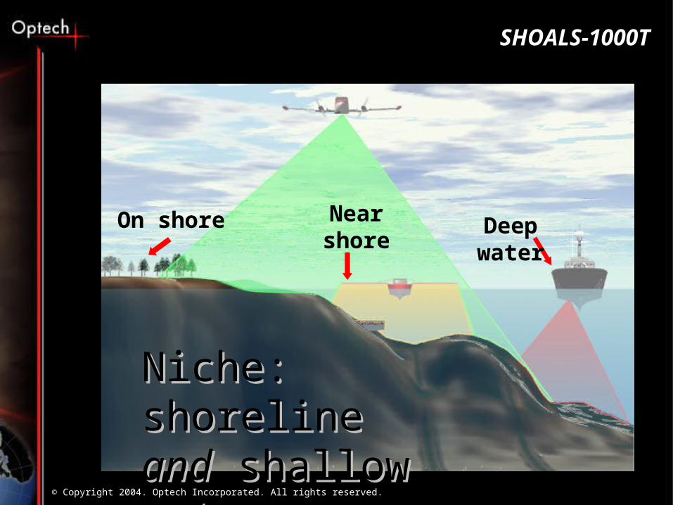
Near shore
Niche: shoreline Niche: shoreline andand shallow water shallow water
SHOALS-1000T
Deep waterOn shore

© Copyright 2004. Optech Incorporated. All rights reserved.
• 1-kHz hydro laser•4 mJ @ 532 nm•3 mJ @ 1064 nm
• 9-kHz topo laser•6 uJ @ 1064 nm
• 4-channel receiver•10 cm aperture
SHOALS-1000T Sensor

© Copyright 2004. Optech Incorporated. All rights reserved.
SHOALS-1000T Consoles
Power Distribution
Laser Power Supply
Laser Electronics
Laser Chiller
18” LCD Display
Mirrored RHDs
Compact Flash
(Or Floppy Drive)

© Copyright 2004. Optech Incorporated. All rights reserved.
SHOALS: Typical Installation

© Copyright 2004. Optech Incorporated. All rights reserved.
SHOALS: Operational Concept
0
20
40
60
80
100
120
140
1 21 41 61 81 101 121 141 161 181
time (ns)
ph
oto
ele
ctr
on
s

© Copyright 2004. Optech Incorporated. All rights reserved.
4 Waveforms per Pulse
0
20
40
60
80
100
120
140
160
1 51 101
151
201
251
301
351
401
451
020406080
100120140
1 51
101
151
0
50
100
150
200
1 51 101
151
010203040506070
1 26 51 76
IR Surface Raman
APD Green PMT Green

© Copyright 2004. Optech Incorporated. All rights reserved.
Design Scan Pattern

© Copyright 2004. Optech Incorporated. All rights reserved.
Altitude
(m)
Swath
(m)
Lateral Spot Spacing
(m)
Forward Spot Spacing
(m)
Flight Speed (knots)
Scanner Cycle Rate
(Hz)
Area Coverage (nm2/hr)
400 60 2 2 124 16.0 4.0 300 60 2 2 124 15.9 4.0
400 130 3 3 127 10.9 8.9 300 125 3 3 128 11.0 8.7
400 215 4 4 126 8.1 14.7 300 165 4 4 162 10.5 14.5
400 230 5 5 180 9.2 22.4
Scan Patterns for Hydrographic Mode

© Copyright 2004. Optech Incorporated. All rights reserved.
Performance Characterization
Depth Measurement Accuracy
Underwater Horizontal Accuracy
Depth Penetration

© Copyright 2004. Optech Incorporated. All rights reserved.
SHOALS 1000T Specifications
• Measurement Rate - - hydro
- topo• Measurement Depth• Depth Penetration• Operating Altitude• Aircraft Speed• Laser Spot Spacing• Swath Width• Measurement Accuracy• Airborne System Weight
1000 Hz9 kHz50 m
kD > 3 (daytime)
200 - 400 m
125 - 175 knots
2x2, 3x3, 4x4, 5x5 m
up to 0.58 x altitude
IHO Order 1
210 kg

© Copyright 2004. Optech Incorporated. All rights reserved.
SFOTC – Ft. Lauderdale (8/03)

© Copyright 2004. Optech Incorporated. All rights reserved.
1 2 3 10 4 9
5 6 7 8
11
Extinction depth = 39m

© Copyright 2004. Optech Incorporated. All rights reserved.
Acoustic depths – SHOALS depths
10386 points; mean difference = 0.145m; sigma = 0.188m

© Copyright 2004. Optech Incorporated. All rights reserved.
IHO-1 Depth Accuracy (95% confidence)
Depth (m)
0.00
0.10
0.20
0.30
0.40
0.50
0.60
0.70
0.80
0.90
1.00
0 10 20 30 40 50
)*13.0()5.0( 22 d

© Copyright 2004. Optech Incorporated. All rights reserved.
Underwater Horizontal Accuracy
Ten 2x2x2 m cubes were placed in the project area

© Copyright 2004. Optech Incorporated. All rights reserved.
Underwater Horizontal Position Accuracy
• Example waveform for 2m cube in 26m depth

© Copyright 2004. Optech Incorporated. All rights reserved.
Multiple detections of a 2m cube at 18m depth
• Grid is 1m x1m
• Yellow and Black squares are averages of 14 eastbound and westbound flights
• Separation of averages is 1.3 meters
eastbound westbound
Avg eastbound Avg westbound

© Copyright 2004. Optech Incorporated. All rights reserved.
Depth Penetration Test
0
20
40
60
80
100
120
140
0 50 100 150 200 250 300 350 400 450 500
PMTReal and simulated pulses:
Kd=0.085 m-1; Albido=0.62
real signal
simulated signal
real signal
simulated signal
0
20
40
60
80
100
120
0 50 100 150 200
APDReal and simulated pulses:
Kd=0.085 m-1; Albido=0.62
real signal
simulated signal
real signal
simulated signal
Courtesy of Viktor Feigels (Optech Int.) and Alan Weideman (NRL)

© Copyright 2004. Optech Incorporated. All rights reserved.
Extinction depth = 39m
Diffuse Attenuation Coefficient:
Kd = 0.09 m-1
Extinction Depth = 39m
Kd * D = 3.5

© Copyright 2004. Optech Incorporated. All rights reserved.
Beyond Safety of Navigation
Auto-extraction of shoreline
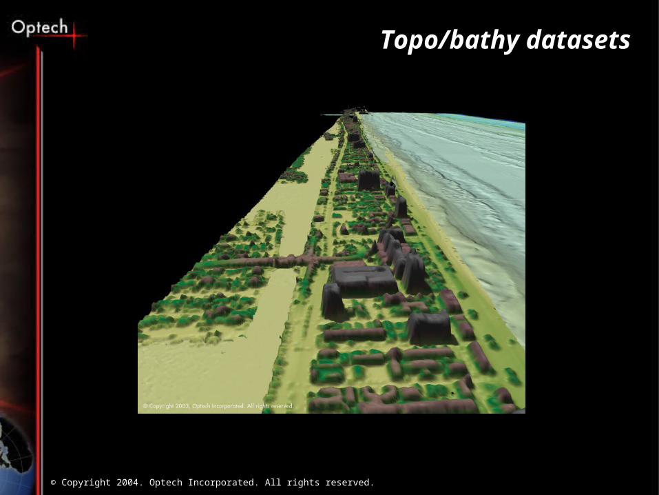
Topo/bathy datasets
SHOALS seafloor images (pseudoreflectance)
3d Benthic mapping and water column data

© Copyright 2004. Optech Incorporated. All rights reserved.
MLLW Shoreline
MHW Shoreline
Private uplands
Inland Waters; Tidelands
Territorial Seas; EEZ; and High Seas
Shoreline Mapping is a 3-D problem
© Copyright 2004. Optech Incorporated. All rights reserved.
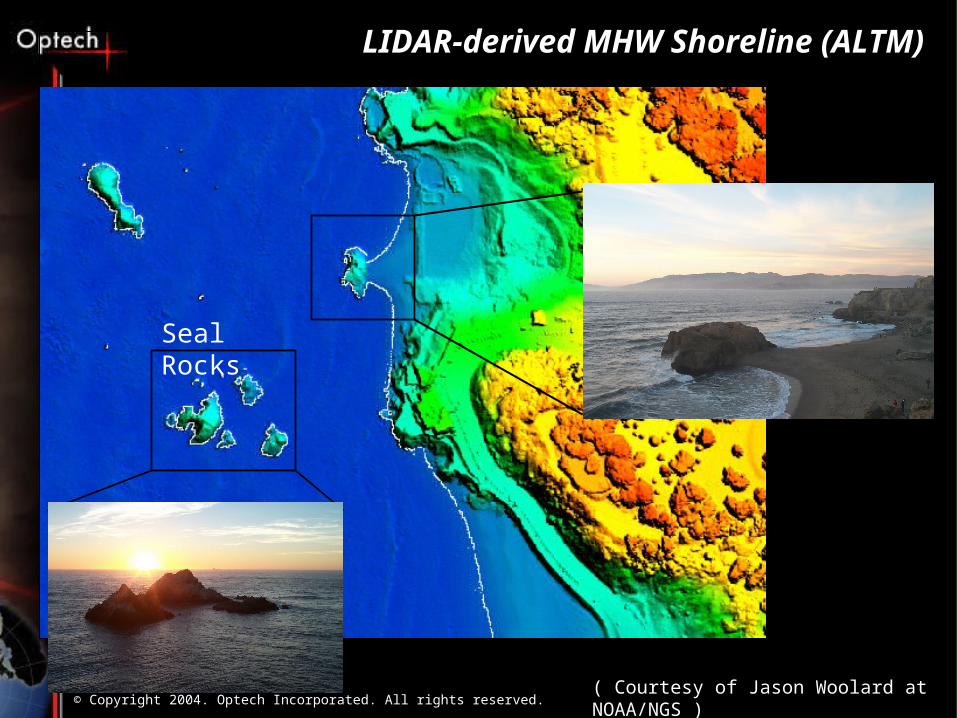
Seal Rocks
( Courtesy of Jason Woolard at NOAA/NGS )
LIDAR-derived MHW Shoreline (ALTM)
© Copyright 2004. Optech Incorporated. All rights reserved.
Topo/bathy datasets
Ft. Lauderdale
Beach Front
© Copyright 2004. Optech Incorporated. All rights reserved.
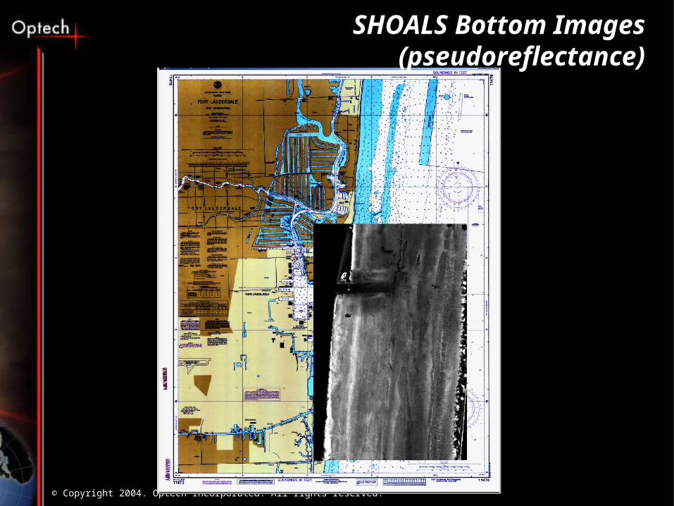
SHOALS Bottom Images (pseudoreflectance)

© Copyright 2004. Optech Incorporated. All rights reserved.
Pseudoreflectance
sec),,(2
2
20
)(
cos)( kDsn
w
rPTr e
DHn
AFPmP
020406080
100120140
1 51
101
151

© Copyright 2004. Optech Incorporated. All rights reserved.
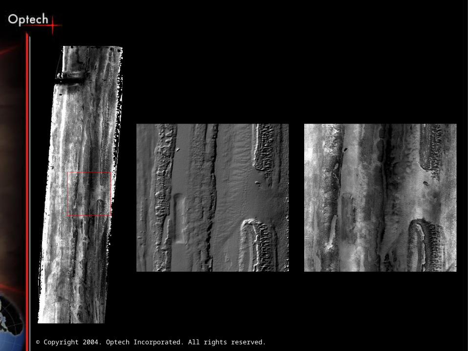
44 flightlines
APD/PMT merged at 12 m
13 Km x 3 Km
6.8 M points
5.0 m pixels
Max D = 37 m
© Copyright 2004. Optech Incorporated. All rights reserved.

© Copyright 2004. Optech Incorporated. All rights reserved.
Laser Data Spectral Data+ =
3D Coastal Landcover and Benthic information
Water column information
Active/Passive Fusion
© Copyright 2004. Optech Incorporated. All rights reserved.
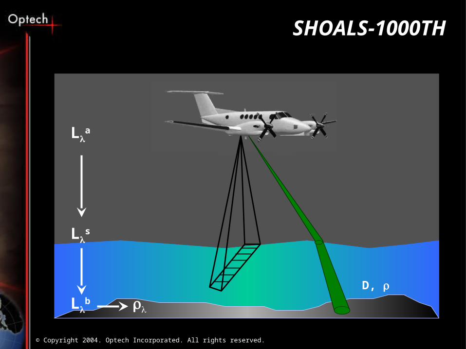
SHOALS-1000TH
D,
La
Ls
Lb
© Copyright 2004. Optech Incorporated. All rights reserved.
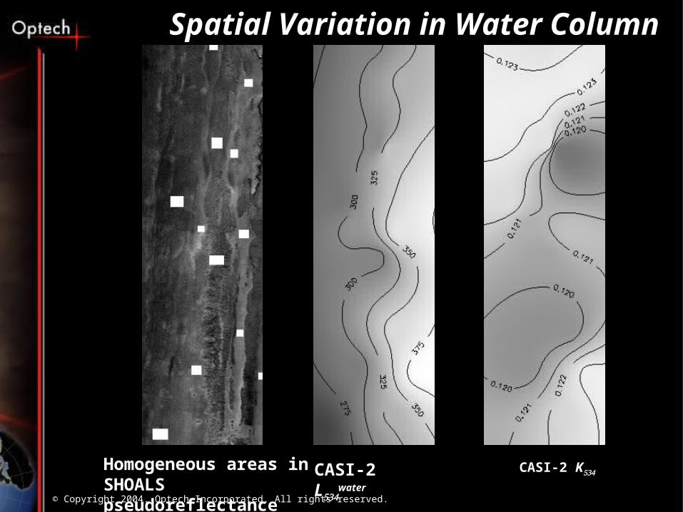
CASI-2 LwaterHomogeneous areas in
SHOALS pseudoreflectanceCASI-2 K
Spatial Variation in Water Column

© Copyright 2004. Optech Incorporated. All rights reserved.
Spectrometer 534 SHOALS 532 DEPTH
Signal level fusion yields 3 data sets for classification

© Copyright 2004. Optech Incorporated. All rights reserved.
SHOALS Fusion Software
SHOALS
spectrometer
waveforms
waveforms
waveforms
depth
radiance
FU
SIO
N P
roce
ssor
SHOALS
Lbottom
Lwater
k

© Copyright 2004. Optech Incorporated. All rights reserved.
Example: Kaneohe Bay, Hawaii
© Copyright 2004. Optech Incorporated. All rights reserved.
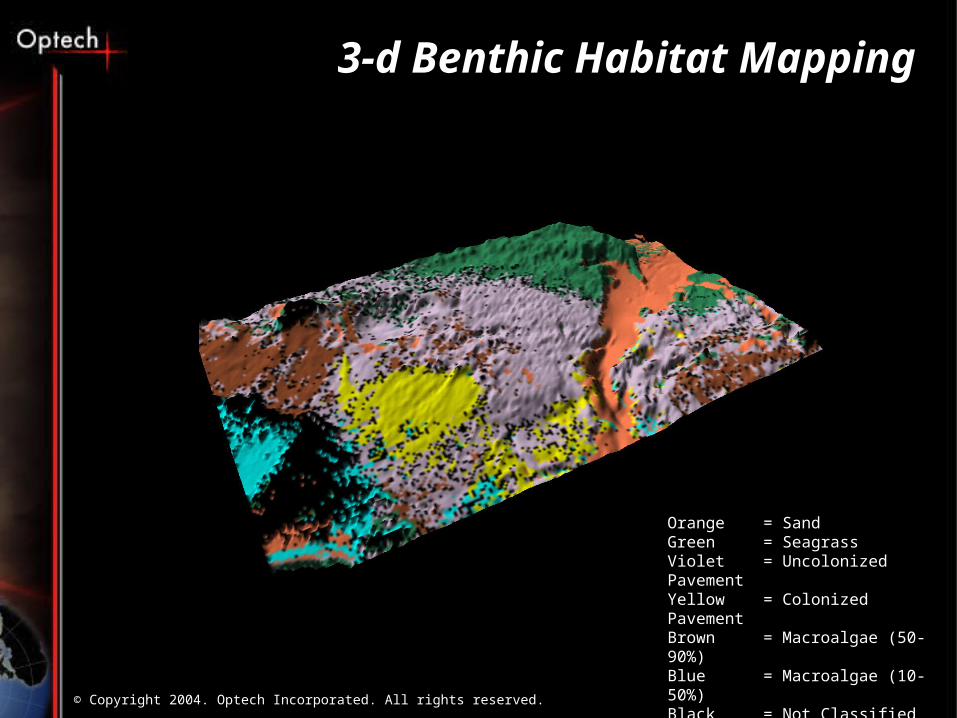
3-d Benthic Habitat Mapping
Orange = SandGreen = SeagrassViolet = Uncolonized PavementYellow = Colonized PavementBrown = Macroalgae (50-90%)Blue = Macroalgae (10-50%)Black = Not Classified
© Copyright 2004. Optech Incorporated. All rights reserved.
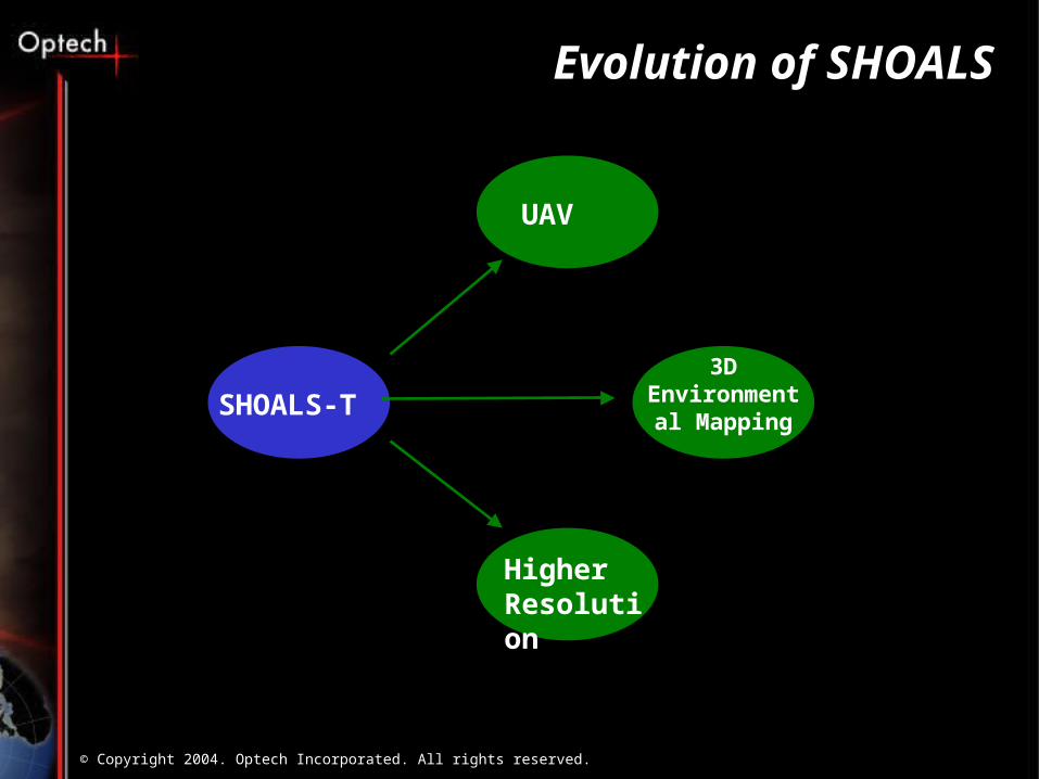
Evolution of SHOALS
SHOALS-T
UAV
Higher Resolution
3D Environmental
Mapping