Embed Size (px)
Citation preview

Chapter 9: From the Andes to the Amazon
Physical Geography
Chapter 10: A Blending of Cultures Human Geography
Chapter 11: Today’s Issues Latin America’s Pressing Events
Latin America

Chapter 9: From the Andes to the Amazon
Section 1: Landforms and Resources
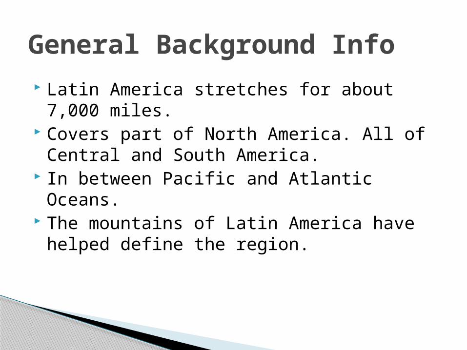
Latin America stretches for about 7,000 miles.
Covers part of North America. All of Central and South America.
In between Pacific and Atlantic Oceans. The mountains of Latin America have
helped define the region.
General Background Info

Chain of mountains through the western portion of North, Central, and South America.◦ Rockies in the United States
Volcanoes present. Serve as a barrier to movement. Where do people settle? Home to some of the most important
historical cultures.
The Andes Mountains


Extremely hilly regions of countries are called Highlands.
Two main highlands in Latin America are both in South America:
Guiana Highlands – Northeast Latin America.
Brazilian Highlands – East coast of Brazil.
Latin American Highlands

Mountains, Highlands, & Plains

Plains offer rich soil and grasses suitable for farming and livestock grazing.
Llanos – situated in Colombia and Venezuela.◦ Grassy and treeless.◦ Similar to the plains in the United States
Amazon Basin – interior of Brazil.◦ Cerrado – savannas with flat terrain and moderate
rainfall.◦ Underdeveloped land.
Pampas – grasslands where soil is extremely rich.◦ Argentina and Uruguay.
Latin American Plains
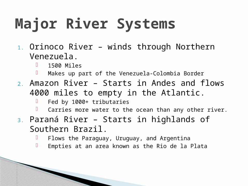
1. Orinoco River – winds through Northern Venezuela.
1500 Miles Makes up part of the Venezuela-Colombia Border
2. Amazon River – Starts in Andes and flows 4000 miles to empty in the Atlantic.
Fed by 1000+ tributaries Carries more water to the ocean than any other river.
3. Paraná River – Starts in highlands of Southern Brazil.
Flows the Paraguay, Uruguay, and Argentina Empties at an area known as the Rio de la Plata
Major River Systems


Inhabited and uninhabited islands in Latin America are broken up into 3 groups:
1. The Bahamas-100’s of islands off coast of Florida and Cuba.
2. The Greater Antilles- larger islands of the Caribbean (Cuba, Jamaica, Hispaniola, and PR)
3. The Lesser Antilles- Southeast of PR. Divided into Wayward and Leeward Islands.
The Islands


Resources Mineral and Energy Resources are the two
most important natural resources found in Latin America.
Tin, Lead, and Nickel most prominent Mineral Resources.
Mined and then exported elsewhere. Oil, coal, natural gas, and Uranium are all
mined in Latin America.

Counts as a Quiz Grade! You will need to complete 4 maps of Latin
America◦ Political Map◦ Climate Region Map◦ Physical Landforms Map◦ Environments Map
All maps must be hand-drawn
Maps Assignment

Chapter 9:From the Andes to the Amazon
Section 2: Climate and Vegetation

Rain forests, deserts, savannas and other areas are all prominently found in Latin Am.
Over 7000 miles there is great variation. Deserts scrubs and rain forests and
everything in between for vegetation. Things affecting climate and vegetation:
1. Distance/span2. Changes in elevation3. Ocean currents from Atlantic and Pacific
Varied Climates and Vegetation

Vegetation Regions of Latin America

Tropical Climate Zones
Tropical Wet Tropical Wet & Dry
Rain forests – dense forests made up of different species of trees.
Unique Ecosystems. Amazon- 2 million sq.
miles. 2500 different species
in the Amazon alone.
Primarily in South America.
Savannas prominent.
Seasonal rains.
Mainly Brazil, Colombia, & Argentina.

Dry Climate Zones
Semiarid Desert
Generally dry – some rain.
Vast, grass covered plains.
Some desert shrubs grow.
Mexico, Brazil, Uruguay, & Argentina.
North Mexico and part of Peru.
Atacama desert in Northern Chile.
Patagonia has a desert.
Mainly Brazil, Colombia, & Argentina.

Mid-Latitude Climate Zones Humid Subtropical Mediterranean
Hot humid summers, rainy winters.
Varied Vegetation
Paraguay, Uruguay, Brazil, Bolivia, Argentina
Dry summers, moist winters.
Part of Chile
Low shrubs and small trees.

Mid-Latitude Climate Zones Marine West Coast Highlands
Cool rainy winters, mild rainy summers.
Chile and Argentina.
Forest is typically the vegetation you find here.
Moderate to cold in temperature
Mountains of Mexico and the Andes
Smallest of any region in Latin America.

How does Elevation effect South American Economies and habitation?
Chapter 9: From the Andes to the AmazonSection 3: Human-Environment Interaction

Reshaping the land by agriculture has been practiced in Latin America for centuries.
The two main types of agriculture reshaping are:1. Slash-and-Burn: cut trees and shrubs. Burn the
trees and shrubs. Use the ash as fertilizer. What are the potential drawback to this?
2. Terraced Farming: used to grow crops on hillsides. Cut step-like ridges into the side of the mountain. • Reduces soil erosion
Reshaping by Agriculture

Reshaping by Agriculture

Argentina, Uruguay, and Venezuela are the most urbanized countries in Latin America.◦ 90% of people live in cities.
Urbanization – What is it? Why does it happen?
Push Factors poor medical care, education, jobs and land usage
Pull Factors better medical care, education, and jobs
Urbanization

Urbanization

Unemployment and Crime increase! Social problems Unemployment Environmental problems Infrastructure issues
What are the problems with rapidly growing cities?

Good◦ Spending money and creating jobs◦ New businesses◦ Port Cities◦ Jobs jobs jobs!◦ Reduces the income gap
Bad◦ Rich-poor gap increases◦ Indigenous poeples◦ Outside money changes the economic landscape
Tourism: Good or Bad?