Embed Size (px)
Citation preview

NGUNorges geologiskeundersøkelseGeological Survey of Norway
Norges geologiske undersøkelse (Geological Survey of Norway), Leiv Eirikssons vei 39, Trondheim.Telephone: national (07) 91 58 60, InternationalN-7001 Trondheim, Norway.
Director: Dr. philos. Knut S. Heier
Bedrock Geology Division: div.director Dr. philos.
Superficial Deposits Division: div.director Bjørn A.
Geophysics Division: div.director Inge Aalstad
Geochemistry Division: div.director Bjørn Bølviken
Peter Padget
Follestad
The publications ofNorges geologiske undersøkelse are issued as consecutively numbered volumes, andare subdivided into two series, Bulletin and Skrifter.
Bulletins comprise scientific contributions to the earth sciences of regional Norwegian, general, or;specialist interest.
Skrifter comprise papers and reports of specialist or public interest of regional, technical, economic,environmental, and other aspects of applied earth sciences, issued in Norwegian, and with an Abstractin English.
EDITOR
Førstetatsgeolog Dr. David Roberts, Norges geologiske undersøkelse, P.0.80x 3006, N-7001Trondheim, Norway.
PUBLISHERUniversitetsforlaget, P.0.80x 1959, Tøyen, Oslo 6, Norway.
DISTRIBUTION OFFICES
Norway: Universitetsforlaget, P.0.80x 2911, Tøyen, Oslo 6. United Kingdom: Globalßook ResoursesLtd., 109 Great Russell Street, London WCIB, 3ND.
United States and Canada: Colombia University Press, 136 South Broadway, Irvington on Hudson,New York 10533.
EARLIER PUBLICATIONS AND MAPSThe most recent list of NGU publications and maps, 'Publikasjoner og kart 1879-1980', appearedin 1981. Copies can be obtained from the Publisher.
The most recent maps available from NGU are listed in the back cover.
MANUSCRIPTS
From 1.1.1984 the NGU Bulletin and Skrifter series will be printed in a 2-column format as e.g.in Norsk Geologisk Tidsskrift. Contributors are asked to prepare their manuscripts in accordancewith the 'Instructions to Authors' printed inside the back cover of NGT. A more comprehensive'Instructions' for potential authors of NGU Bulletin and Skrifter papers will be issued early in 1984.
+ 47 7 91 58 60.Postal address: Box 3006,
The Silurian succession of the Oslo \ IDAVID WORSLEY, NILS AARHUS, MICHAEL G. BASSETT, MICHAEL " *\#ATLE MØRK & SNORRE OLAUSSEN
i i nm Worsley, D., Aarhus, N., Bassett, M.G., Howe, M.P.A., Mørk, A. & Olaussen, S. 1983:: »£) The Silurian succession of the Oslo Region. Nor. geol. unders. 384, 1-57.
j The marine Silurian succession of the Oslo Region displays a great variety of mixed clastic and carbonate lithofacies. Maximum thicknesses (<650 m) and most complete suc
cessions are seen in the central parts of the region in the Ringerike and Asker districts.Existing numerical stratigraphical units are based on a mixture of faunal and lithological
- IPQ ctiteria and are often diachronous. We herein propose the replacement of this scheme
sectors oftheIthroughouttheCaledonidesregion by aduringseries oftheformalLlandovery and Wenlock.lithostratigraphical Ourunits andworkusehas restrictedexisting such
itself to the marine Silurian succession; the transition to the overlying red bed depositsof the Ringerike Group occurred in the late Wenlock in the Ringerike district. In orderto present a complete review of Silurian deposits of the Oslo Region we alsogive a brief description of the red bed sequence.
David Worsley, Paleontologisk museum, Sars gate 1, Oslo 5, NorwayNils Aarhus, IKU, Continental Shelf Institute, Postboks 1883, N-7001 Trondheim, NorwayMichael G Bassett, National Museum of Wales, Cardiff CF1 3NP, UKMichael P.A. Howe, Department ofEarth Sciences, Downing Street, Cambridge CB2 3EQ,
Atle Mørk, IKU, Continental Shelf Institute, Postboks 1883, N-7001 Trondheim, NorwaySnorre Olaussen, Geologisk Laboratorium, Statoil, Postboks 300, N-4001 Stavanger,
|k-! Norway
units where possible. In these terms the entire marine succession corhprises two groupsand eleven formations, all of which are defined and described in this paper. Our newinformation on the age relationships and depositional environments of these units permits
] a new appraisal of the palaeogeographical evolution of the Oslo Region and adjacent
rCONTENTS
Introduction 2Stratigraphy 4
The Bærum Group 8
The Solvik Formation 9The Sælabonn Formation 16The Rytteråker Formation 19The Vik Formation 22The Ek Formation 25The Bruflat Formation 27The Reinsvoll Formation 30The Skinnerbukta Formation 30
The Hole Group 32
The Braksøya Formation 33The Malmøya Formation 36The Steinsfjorden Formation 38
The Ringerike Group 42
Synthesis 44Acknowledgements 53References 53
2 D. WORSLEY, N. AARHUS, M. G. BASSETT, M. P. A. HOWE, A. MØRK & S. OLAUSSEN
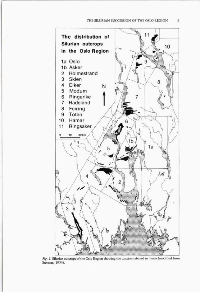
IntroductionThe marine Lower Palaeozoic succession of the Oslo Region is approximately1,250 m thick and is overlain by a similar thickness of late Silurian red beds. Thissedimentary suite is exposed within a NNE-SSW trending graben (Fig. 1) whichappears to have developed mainly in the Carboniferous and Permian (Ramberg& Spjeldnæs 1978, Olaussen 1981a). Regional facies mosaics and thicknessvariations in the Lower Palaeozoic succession reflect the foreland character of the
Oslo Region between the developing Caledonide orogenic zone (Nicholson 1979)and the cratonic development seen further east on the Baltic Shield. These featuresprompted Størmer (1967) to suggest that Lower Palaeozoic sediments weredeposited in an intracratonic syneclise which corresponded generally to the youngerPermo-Carboniferous graben structure. Størmer tentatively associated this syneclise with other Lower Palaeozoic basins along the southwestern and southernmargins of the Baltic Shield (e.g. in Scania and Poland). An alternative hypothesisby Ramberg (1976) rather suggests the development of the Oslo Region as oneof a series of offset fault-bounded basins along the margins of the shield area. Bothauthors clearly supposed that the margins of the Oslo Region's Lower Palaeozoicbasin structure were generally coincident with those of the later Permian graben.
Lower Palaeozoic sequences are exposed throughout the region between Permianintrusive and extrusive complexes. Interpretation of the original geographicalrelationships of present exposures is complicated by earlier Caledonian deformation which had markedly different effects throughout the region. Exposures insouthern districts show gentle dips, but WSW-ENE striking folds increase inintensity northwards to Mjøsa where Lower Palaeozoic rocks are exposed in highlydeformed parautochthonous sequences immediately adjacent to major southeastwards directed thrust planes (Nicholson 1979, Nystuen 1981). The appreciablecrustal shortening produced by Caledonian deformation must be borne in mindwhen assessing the lateral facies variations observed in present exposures. In spiteof these complications, exposures are both widespread and often exceptionallyfossiliferous. These features make the region an excellent area for detailedstratigraphical studies and many contributions through the last 150 years haveproduced progressively more refined correlations of the Lower Palaeozoic succession (see review by Henningsmoen 1960).
Although the age relationships of Cambrian and Ordovician sequences arerelatively well understood, Silurian rocks have hitherto been poorly dated and theirfacies mosaics have often been misinterpreted because of erroneous intraregionalcorrelations. This situation has developed, ironically enough, as a result of themonumental work of Kiær (1908) which described in detail the marine Siluriansuccession of the Oslo Region. Kiær's impressive descriptions and advancedinterpretations of regional facies patterns had such a great impact that his workwas long accepted as a definitive treatise on this part of the Lower Palaeozoicsequence. Much scientific activity was consequently directed to Cambrian andOrdovician units and only isolated aspects of the palaeontology and geology of theSilurian succession have been described in the last 75 years. Key reviews of theSilurian sequence in parts or all of the region are those of Henningsmoen (1960),
3THE SILURIAN SUCCESSION OF THE OSLO REGION
Fig. 1. Silurian outcrops of the Oslo Region showing the districts referred to herein (modified fromStørmer, 1953).
4 D. WORSLEY, N. AARHUS, M. G. BASSETT, M. P. A. HOWE, A. MØRK & S. OLAUSSEN
Seilacher & Meischner (1964), Whitaker (1965, 1966), and Bjørlykke (1974a).These, and most other contributions until recently, generally accepted the originalstratigraphical scheme of Kiær (1908), although some studies either questionedor altered some of Kiær's correlations (e.g. Henningsmoen 1954, Spjeldnæs 1957& 1966, Hagemann 1966, Heintz 1969). A reconnaissance survey by Bassett &Rickards (1971) highlighted the diachronous nature of many of Kiær's unitssuggested by the above works. The need for a comprehensive revision of theexisting stratigraphical scheme for Silurian rocks throughout the Oslo Region wasevident.
A study of the regional stratigraphy and depositional environments of themarine Silurian succession was therefore initiated in 1976, both as a part of project'Paleostrat' at the Paleontologisk museum, University of Oslo (grant no. D.40.38-6 from NAVF, the Norwegian Council for Science and the Humanities)and as a Norwegian contribution to IGCP project 'Ecostratigraphy'. Severalresearch students and foreign workers have contributed to this study andbiostratigraphical, palaeoecological and sedimentological surveys of most districtsand stratigraphical units of the Oslo Region's marine Silurian succession are nowin progress or have been completed recently. All this work makes it necessary topropose herein a lithostratigraphical framework for the entire sequence as a basisfor further publications. We also present brief summaries of our biostratigraphicaland sedimentological interpretations to demonstrate the chronological and palaeogeographical relationships of our major lithostratigraphical units. In order topresent a complete review of present knowledge of the Silurian development ofthe Oslo region, we also give a brief summary of lithostratigraphical andsedimentological studies carried out in recent years on the late Silurian nonmarinered bed sequence (see especially Whitaker 1965, Turner '1974a,b,c and Turner& Whitaker 1976).
StratigraphyPresent Stratigraphical Scheme
The numerical classification of the Lower Palaeozoic succession of the Oslo Regionis based on a sequence of units first proposed by Kjerulf (1857). Kjerulf dividedthe marine deposits of the Oslo district into 'Etagen' 1 to 8*; this terminology wasfurther developed , modified and elaborated by subsequent workers. However,units were often defined using a mixture of bio- and lithostratigraphical criteria,and this is clearly seen in Kiær's (1908) proposals for the Silurian sequence.
Kiær redefined and refined Kjerulf s nomenclature and used this numericalsystem as his primary form for the division and correlation of the sequence in thevarious districts of the region. He divided marine Silurian rocks into stages 6 to9; although he did not study the overlying red beds, he assigned them to stage10 (Kiær op.eit. Profiltafel 1) which he defined as 'Devonian sandstone and
* the German term 'Etage' is hereafter called stage, according to common usage, but with nochronostratigraphical implications.

THE SILURIAN SUCCESSION OF THE OSLO REGION 5
conglomerate'. Kiær subdivided his major units using an alphabetical subnotation(e.g. 6a, 6b) and further subdivisions were based on the Greek alphabet (e.g. 6b/?)with numerical subscripts (e.g. 6bf3 x ). He often complemented this procedure withdescriptive names for each subunit in order to highlight characteristic fossils (e.g.6b, Ringerike: 'Die Zone mit Rhynchonella Weaveri'). Many such units are inreality lithologically based, and Kiær's 6b in Ringerike is a sandstone-dominatedunit between two more shaly sequences.
Kiær also defined units on a mixed litho- and biostratigraphical basis ('DieZonen Ba-b oder der Monograptusschiefer') or only on lithological character ('Bd:Die Zonen mit dem Malmøkalk').
Kiær (1920) subsequently adopted a different approach to the stratigraphicalsubdivision of the Silurian succession in a paper describing algae from theRingerike district. He there introduced a classiflcation based on 'groups' (e.g. theStricklandia and Pentamerus groups in his Lower Silurian Series) and he alsointroduced some zonal subdivisions without using numerical designations.However, these zones were also based on both litho- and biostratigraphical criteria(e.g 'the zone with the finely nodular Rhynchonella nucula limestone'). Hepromised a more comprehensive presentation of these new divisions, but otherresearch and administrative duties prevented this work. Subsequent papers on theSilurian stratigraphy of the region followed Kiær's original numerically andalphabetically based subdivisions with their descriptive names. However, thegroups proposed by Kiær (1920) were redefined as 'series' (Holtedahl 1953,Strand & Størmer 1955, Henningsmoen 1960). The resultant stratigraphicalscheme for the Silurian rocks of the Oslo Region included subdivisions groupedinto the Stricklandia (Stage 6), Pentamerus (7) and Lower (8) and Upper Spiriferid(9) series. Although recognizing the mixture of lithological and faunal criteria usedfor the definition of these units, Henningsmoen (1955) suggested that they couldbe assigned chronostratigraphical relevance, and this view has been followed bymost workers until recently. Strand & Størmer (1955) also introduced alithostratigraphically based terminology for the northern districts of the region,based on information which was published subsequently by Skjeseth (1963).
Stages 6 and 7 were originally correlated by Kiær (1908) with the British Lowerand Upper Llandovery, Stage 8 with the Wenlock and Stage 9 with the Ludlow.Subsequent studies of vertebrate and other faunal elements (e.g. Henningsmoen1954, Heintz 1969, Bassett & Rickards 1971, Bockelie 1973 and Turner & Turner1974) rather suggest that the entire marine sequence should be assigned to theLlandovery and Wenlock, the transition to the overlying red beds occurring closeto the Wenlock—Ludlow boundary. Continual revisions of the biostratigraphicalzonation of Llandovery and Wenlock sequences elsewhere have produced adetailed framework which now enables relatively precise correlations to be madethroughout the Oslo Region between different sedimentary facies. Ofespecial noteare works on graptolites (Bjerreskov 1975, Rickards 1976), brachiopod phyleticlineages (Williams 1951, Ziegler 1966, Rubel 1977, Johnson 1979 and Mørk1981), conodonts (Aldridge 1975) and other microfossils (Aldridge et al. 1979).Important biostratigraphical syntheses have also been presented by Ziegler, Cocks
6 D. WORSLEY, N. AARHUS, M. G. BASSETT, M. P. A. HOWE, A. MØRK & S. OLAUSSEN
& McKerrow (1968), Cocks (1971) and Cocks, Holland, Rickards & Strachan(1971). Comparisons of our data with these works have shown that most of the(both major and minor) currently accepted stage units are diachronous when tracedthrough the Oslo Region.
We have considered several possible revisions of the present scheme: in viewof the long-established use of the numerical stage system we could, for example,retain this scheme, either by redefinition and adjustment of unit boundaries or byrecognition and tabulation of their informal and diachronous nature. However,we consider that such a procedure would increase existing confusion; furthermore,this numerical notation masks the facies variations observed throughout the region.We believe that an entirely new approach to the stratigraphical problems of theOslo Region's Silurian sequence is warranted and therefore propose here formaland mappable lithostratigraphical units throughout the region and designatestratotypes for each unit. These units are of formational rank and are intended toreplace the previously accepted four 'series' of the Silurian succession. We foreseea transitional period, especially prior to forthcoming detailed descriptions ofindividual units, where Kiær's minor subdivisions (e.g. 6b/3) will still have to beused within our formational framework: we propose that these be used only as localand informal descriptive terms with no intraregional correlative significance.
The maps of Kiær (1908) provide an adequate basis for tracing our formationalboundaries in most districts. Although we reorganize Kiær's units into our newformations in each area, our formational boundaries always follow (within anyreasonable mappable scale) unit boundaries displayed on Kiær's maps. Anexception is the northern districts where Silurian exposures were only brieflydescribed and not mapped by Kiær. In these districts our own detailed studiesgenerally support the proposals and summary map of Skjeseth (1963).
Geographical nomenclatureStørmer (1953) divided the Oslo Region into eleven districts in his descriptionof Ordovician stratigraphy. Silurian outcrops occur in all of these districts but arebest preserved in eight of them. Størmer's district 1 (Oslo-Asker) comprises themunicipalities of Oslo, Bærum and Asker. We distinguish herein between Silurianexposures in Oslo (la) and those in Bærum and Asker (lb-grouped under the nåmeAsker) as shown in Fig. 1. For ease of reference we call Størmer's district 3 the Skiendistrict and his district 10 the Hamar district. We use the terms central (Oslo andAsker), western (Holmestrand, Modum, Eiker and Ringerike), southern (Skien)and northern (Hadeland, Toten, Hamar and Ringsaker) districts in a purelygeographical sense. Although Kiær (1908) discussed palaeogeographical relationships in terms of 'eastern', 'western' and 'mixed' facies developments, our workindicates the inadequacy of such a simple palaeogeographical zonation.
Places names used for our new formations are taken from those printed on the1:50,000 maps of the Norwegian Ordinance Survey (NGO), or on local economicor tourist maps where the former do not display the relevant nåme. Grid referencesare also taken from NGO maps using the M7ll grid of the 1:50,000 series. Themost important localities referred to in the text for the definition and descriptionof our units are shown in Figs. 2a—3b.
7THE SILURIAN SUCCESSION OF THE OSLO REGION
There is at present some disagreement as to the naming of Norwegianlithostratigraphical units. Some workers maintain that the definite article endingsof many place names should be retained in English language manuscripts as theyappear an official maps (e.g. The Steinsfjorden Formation, as used herein). Thealternative view (The Steinsfjord Formation) follows a ruling of the NorwegianLanguage Council in 1981. Nomenclature used in this paper has been acceptedby NGU pending rulings from the newly established Norwegian StratigraphicalCommittee. Future usage of our formational units must follow that commission'srecommendations on this question.
New lithostratigraphical unitsWe here propose and describe eight new formations in the marine Siluriansequence of the Oslo Region; we also redefine and describe three units previouslyproposed by Skjeseth (1963) in the northern districts of the region. To complementthe lithostratigraphical scheme previously established for the overlying red bedsof the Ringerike Group (see p. 42) we also propose the establishment of the Bærumand Hole Groups to embrace the entire complex of marine facies described below.The fence diagram presented in Fig. 4 shows each formationa extent and thicknessvariations between major exposure areas through the region. We introducemember subdivisions in the type areas of some of the formations, but stress thatthe lack of formal proposals of members in many of our formational units reflectspresent state of research rather than lithological variation. Future refinements willresult in the definition ofadditional members to characterise the total facies mosaic
present.Summaries of each formationa depositional environments are based on
palaeoecological and sedimentological analyses which will be presented inlater papers. Our palaeoecological work is best summarized using the 'BenthicAssemblage' concept of Boucot (1975). Individual palaeocommunities are assigned to one of the six assemblages proposed by Boucot, ranging from intertidal(Benthic Assemblage 1) through to deep water (Benthic Assemblage 6) faunas.
The age of each formation is briefly discussed using key faunal elements. Ourcorrelation chart (Fig. 5) reflects present biostratigraphical knowledge in the majordistricts of the region and is conservative in the respect that we only depictdiachronous formational relationships where we have concrete biostratigraphicalevidence at this stage of our work. The chart does not attempt to infer the entirespectrum of formational diachroneity which we believe to exist within and betweenthe districts of the region. Such refinements must await the results of more detailedbiostratigraphical studies within each formational unit and district. In Fig. swealso show the relationship between Kiær's numerical units and our formationalscheme in each district. We have found it natural to correlate our units with the
standard stratigraphical scheme for the British Silurian sequence (Fig. 5, see Cocks,Holland, Rickards & Strachan 1971). Stages for the Wenlock and Ludlow Serieswhich we use here were first proposed by Bassett, Cocks, Holland, Rickards &Warren (1975); these have now been formally accepted as international standards(Martinsson, Bassett & Holland 1981). The status of the Llandovery Series and

8 D. WORSLEY, N. AARHUS, M. G. BASSETT, M. P. A. HOWE, A. MØRK & S. OLAUSSEN
Fig. 2a, b. Maps showing key locations of exposures in the Oslo and Ringerike districts
its stages has not yet been formalised internationally but we find it useful tocorrelate our units with the local British divisions of the Llandovery Series proposedby Cocks, Toghill & Ziegler (1970).
THE BÆRUM GROUP
The group's nåme is based on the municipality of Bærum. The group comprisesthe mixed clastic and carbonate marine sequences found throughout the OsloRegion which we assign to the Solvik, Sælabonn, Rytteråker, Vik, Ek, Bruflat andSkinnerbukta Formations; all of these units are defined and described below.
The base of the Bærum Group throughout the region is everywhere coincidentwith the lowermost occurrence of rocks earlier assigned to stage 6. In the Oslo,Asker and Holmestrand districts this corresponds to the base of our SolvikFormation; the boundary stratotype for the base of the Bærum Group is thereforethat defined for the Solvik Group on Hovedøya in the Oslo district. In otherdistricts the group's base corresponds to the base of our Sælabonn Formation. The
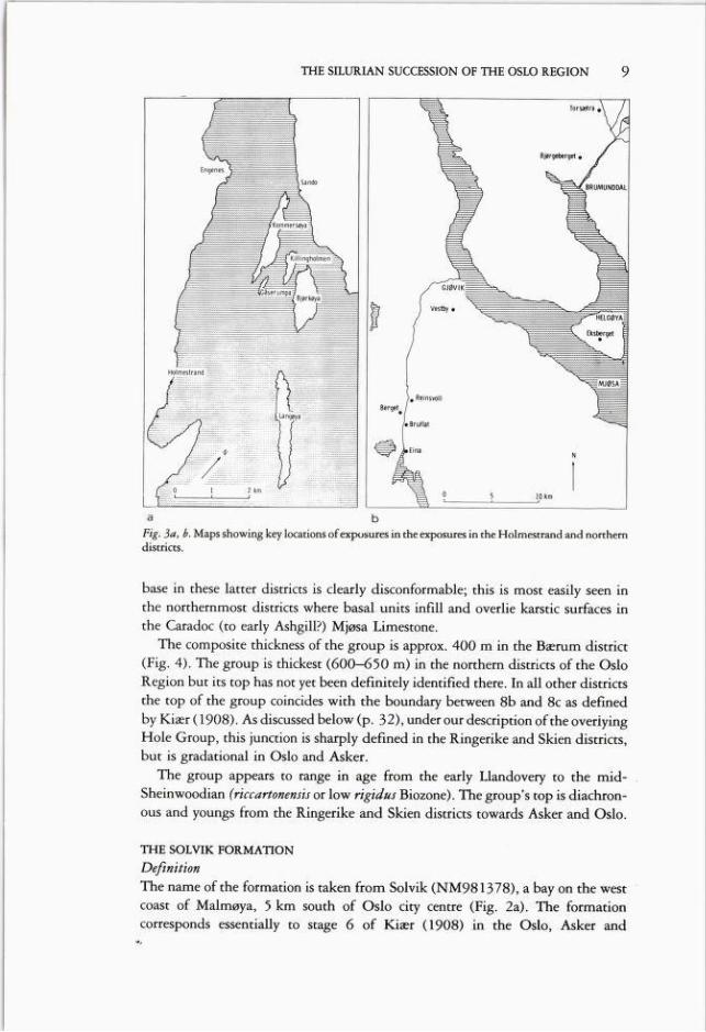
THE SILURIAN SUCCESSION OF THE OSLO REGION 9
a b
Fig. 3a, b. Maps showing key locations ofexposures in the exposures in the Holmestrand and northerndistricts.
base in these latter districts is clearly disconformable; this is most easily seen inthe northernmost districts where basal units inflll and overlie karstic surfaces inthe Caradoc (to early Ashgill?) Mjøsa Limestone.
The composite thickness of the group is approx. 400 m in the Bærum district(Fig. 4). The group is thickest (600-650 m) in the northern districts of the OsloRegion but its top has not yet been definitely identifled there. In all other districtsthe top of the group coincides with the boundary between 8b and 8c as deflnedby Kiær (1908). As discussed below (p. 32), under our description of the overiyingHole Group, this junction is sharply deflned in the Ringerike and Skien districts,but is gradational in Oslo and Asker.
The group appears to range in age from the early Llandovery to the mid-Sheinwoodian (rtccartonensis or low rigidus Biozone). The group's top is diachronous and youngs from the Ringerike and Skien districts towards Asker and Oslo.
THE SOLVIK FORMATION
DefinitionThe nåme of the formation is taken from Solvik (NM981378), a bay on the westcoast of Malmøya, 5 km south of Oslo city centre (Fig. 2a). The formationcorresponds essentially to stage 6 of Kiær (1908) in the Oslo, Asker and

10 D. WORSLEY, N. AARHUS, M. G. BASSETT, M. P. A. HOWE, A. MØRK & S. OLAUSSEN
N
Steinsfjorden Fm
Malmøya Fm
Skinnerbukta Fm
Vik Fm
Rytteråker Fm
»z->ii Solvik Fm
RINGERIKE
HOLMESTRAND
øli

THE SILURIAN SUCCESSION OF THE OSLO REGION 11
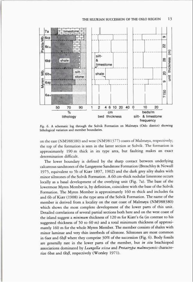
Holmestrand districts. The Solvik Formation is characterised by dominant shaleswith very thin to thin siltstone and limestone intercalations (all quantitative termswhich describe bedding and bed thicknesses used herein follow the scheme ofIngram 1954). Lithological variation (Fig. 6) suggests a twofold division into theMyren and Padda Members in the formationa type area on the Malmøya groupof islands in the Oslo district. A complete type section cannot be designated andthe basal stratotype of the Solvik Formation is defined on the south coast ofHovedøya (NM975412). Reference sections through the lower and upper partsof the formation are well exposed in two faulted but relatively continuous profiles
RINGERIKE
Reinsvoll Fm
Fig. 4. A fence diagram displaying thickness variations of the marine Silurian succession throughoutthe Oslo region.

12 D. WORSLEY, N. AARHUS, M. G. BASSETT, M. P. A. HOWE, A. MØRK & S. OLAUSSEN
Fig. 5. A tentative correlation of the formational units proposed and described herein; comparisonswith the previous numerically-based units are presented for each district.
13THE SILURIAN SUCCESSION OF THE OSLO REGION
lithology bed thickness silt- & limestonefrequency
Fig. 6. A schematic log through the Solvik Formation on Malmøya (Oslo district) showinglithological variation and member boundaries.
on the east (NM988380) and west (NM981377) coasts of Malmøya, respectively;the top of the formation is seen in the latter section at Solvik. The formation isapproximately 190 m thick in its type area, but faulting makes an exactdetermination difficult.
The lower boundary is defined by the sharp contact between underlyingcalcareous sandstones of the Langøyene Sandstone Formation (Brenchley & Newall1975, equivalent to 5b of Kiær 1897, 1902) and the dark grey silty shales withminor siltstones of the Solvik Formation. A 60-cm-thick nodular limestone occurs
locally as a basal development of the overlying unit (Fig. 7a). The base of thelowermost Myren Member is, by definition, coincident with the base of the SolvikFormation. The Myren Member is approximately 160 m thick and includes 6aand 6b of Kiær (1908) in the type area of the Solvik Formation. The nåme of themember is derived from a locality on the east coast of Malmøya (NM988380)which shows the most complete development of the lower parts of this unit.Detailed correlations of several partial sections both here and on the west coast ofthe island suggest a minimum thickness of 120 m for Kiær's 6a (in contrast to hissuggested thickness of 50 to 60 m) and a total minimum thickness of approximately 160 m for the whole Myren Member. The member consists of shales withminor laminae and very thin interbeds of siltstone. Siltstones are most commonin 6a« and 6b/? where they comprise 30% of the succession (Fig. 6). Body fossilsare generally rare in the lower parts of the member, but in situ brachiopodassociations dominated by Leangella scissa and Protatrypa malmoeyensis characterize 6ba and 6b/3, respectively (Worsley 1971).
14 D. WORSLEY, N. AARHUS, M.G. BASSETT, M. P. A. HOWE, A. MØRK & S. OLAUSSEN
Fig. la, b. The basal stratotype of the SolvikFormation on Hovedøya and the fbrmation'stop on Malmøya (Oslo district).
The Padda Member corresponds in general to 6c of Kiær (1908) in the Malmøyaarea. Its nåme is derived from a small island northeast of Malmøya (NM992390)where the upper parts of the unit are well exposed, but its base is defined in acomplete 30 m-thick type section on the west coast of Malmøya (NM981377).Although shales also dominate this member, thin interbeds and lenses of bothcalcareous siltstone and limestone occur together with calcareous nodules. The baseof the Padda Member is defined at the sharp introduction of these interbeds abovethe highly shaly upper parts of the underlying units. Characteristic faunal elementsare both in situ and reworked populations of Stricklandia lens; other brachiopods,bryozans, corals and stromatoporoids are also common.
The dominantly shaly Padda Member grades rapidly into the thinly interbeddedlimestones and shales (in approximately equal proportions) of the overlyingRytteråker Formation (Fig. 7b); the junction is taken at the first appearance offinely nodular limestone horizons assigned to the Rytteråker Formation. Beddingplane exposures show that many of these nodules are carbonate infills of endichnialburrows in the shales.
Other occurrences
The Solvik Formation is also seen in many exposures in the Asker and Holmestranddistricts and its total thickness appears to be relatively constant.
THE SILURIAN SUCCESSION OF THE OSLO REGION 15
The siltstones of the Myren Member thin and decrease in abundance westwardsfrom the type area to Asker where beds which can be assigned to this unit interfingerwith a more calcareous shale development throughout 6a and 6b of Kiær (1908).Maris and limestones in Kiær's 6ca at Spirodden (NM840338) contain bothStrkklandia lens, abundant tabulate corals and stromatoporoids; these beds shouldbe assigned to a new, as yet formally undefined, unit with member status (Baarli1981). The occurrence of benthic algae in this unit at Spirodden was commentedupon by Lauritzen & Worsley (1974) and Mørk & Worsley (1980). Kiær (1908)defined 6q3 in Asker as a 10 m-thick shaly sequence which he assumed to bedirectly overlain by the limestones ofstage 7. However, a series ofnew road cuttingsnot available to Kiær show a 60 m thick sequence of shales and siltstones whichlie between Kiær's 6ca and the overlying Rytteråker Formation. A detailed studyof the entire Solvik Formation in the Asker district now in progress will result inthe definition of several new members in this area (Baarli 1981).
Only the uppermost 25 m of stage 6 are exposed in the Holmestrand districton the island of Bjørkøya (NL764986) and these were re-examined by Mørk(1977). Both this exposure and cores from test boreholes through the entire lowerSilurian succession in the subsurface of the neighbouring island of Langøyademonstrate a facies development clearly assignable to the Solvik Formation.Small, highly metamorphosed, exposures through parts of the formation are alsoseen on the island of Tofteholmen and on the nearby coast of Hurumlandet(Brøgger 1931).
Depositional environmentsThe shale-dominated sequence of the Solvik Formation reflects the rapid earlySilurian transgression of the Oslo, Asker and Holmestrand districts and theestablishment of sublittoral depositional environments in these areas. Siltstonesof the Myren Member in the type area were storm generated and deposited in quietmuddy environments below normal wave base. Exposures through equivalentlower parts of the Solvik Formation in the Asker district show notably fewersiltstone intercalations than the type area and calcareous interbeds are morecommon. The transition to the shale and limestone facies of the Padda Member
is abrupt in the type area. Both sedimentary structures and fauna indicate theestablishment of shallower environments with intermittent periods of both currentand wave reworking of the sea floor. Storm-generated siltstones seen in 6q3 inAsker and Holmestrand are thought to be time equivalents of the Padda Member.In contrast to the depositional regime of the lower parts of the formation, the Askerand Holmestrand districts were now in a more proximal situation than the typearea. Faunal associations seen throughout the Solvik Formation in all three districtscorrespond generally to Benthic Assemblages 5 and 4 of Boucot (1975).
AgeGraptolites and abundant brachiopods form the basis for our dating (Fig. 5). Boththe basal nodular horizon and immediately overlying shales contain sparse andnon-diagnostic shelly faunas, but we have found Climacograptus transgrediens
16 D. WORSLEY, N. AARHUS, M. G. BASSETT, M. P. A. HOWE, A. MØRK & S. OLAUSSEN
lim above the base of the for
mation on Ormøya (Fig. 2a). Thisgraptolite ranges from the Pupperpersculptus to lower acuminatusBiozones elsewhere and the base of
the Solvik Formation therefore approximates to the Ordovician/Silurian boundary as taken at thebase of the persculptus Biozone.Occurrences of subspecies ofStricklandia lens in the Asker dis
trict indicate that the top of theformation there approximates tothe Idwian/Fronian transition(Baarli 1981).
THE SÆLABONN FORMATION
DefinitionThe Sælabonn Formation is best
demonstrated in the Ringerike district (Fig. 2b) in a series of smallcoastal exposures around Sælabonn, a small bay in the northernpart ofTyrifjorden. This formationcorresponds in general to stage 6 ofKiær (1908) in the Ringerike,Skien, Hadeland, Toten, Hamarand Ringsaker districts. Our proposal incorporates the HelgøyaQuartzite of Skjeseth (1963), reduced to member rank, in the threelatter districts. The Sælabonn For
mation is approximately HOmthick in its type area, where it ischaracterised by varying proportions of sandstone, siltstone and
Store Svartøya
(NM 678585)
Fig. 8. A schematic section through the basal boundary stratotype of the Sælabonn Formation, StoreSvanøya, Ringerike. For legend, see Fig. 9.
shale. Sandstones dominate the middle part of the unit and lithological variationwas dearly the basis for Kiær's (1908) tripartite subdivision into 6a, b & c. Formalproposals for subdivision into three members approximately equivalent to Kiær'sunits will result from work in progress in the Ringerike area (Thomsen 1981).
The entire Sælabonn Formation is not exposed in any one section in the typearea; the basal stratotype for the formation is defined on Store Svartøya(NM678585) where the lower lim of the formation are also exposed (Fig. 8).A reference section through the middle of the unit is exposed on the east coast ofSælabonn (NM696606) and its upper parts are well displayed in the basal
THE SILURIAN SUCCESSION OF THE OSLO REGION 17
Fig. 9. Symbols used in the stratigraphic sections presented herein.
stratotype for the overlying Rytteråker Formation at Limovnstangen (p. 20). Thebase of the Sælabonn Formation is defined on Store Svartøya where crinoidalbiosparites of 5 b show a karstic upper surface and are overlain by silty shales withminor thin limestones and siltstones (Fig. 8). This 20 m-thick lower developmentof the formation coarsens up into medium to thickly bedded sandstones withminor siltstones and shales (6b of Kiær 1908, 50 m thick). These further fine upinto thin to medium interbeds of siltstone and shale with increasing limestoneintercalations towards the junction with the overlying Rytteråker Formation.
Other occurrences
Exposures elsewhere in the Ringerike and Skien districts indicate a similar tripartitedevelopment to that of the type area. The base is exposed at several localities inthe southern parts of the Skien district (e.g. Skrapekleiv NL381523) where siltyshales of the formation overlie a thin (0.5-1 m) very coarse sandstone which hasan erosive contact with small biohermal structures and biosparites of upper 5 b(Rønning 1979). Exposures north of Skien at Jønnevall in Gjerpendalen(NL321708) show an erosive contact with sb, but the base of the formation thereconsists of sandstones which grade up into the silty shales assigned to 6a by Kiær(1908). Metamorphosed outcrops assigned to this formation are also seen in theEiker district.
In Hadeland, Owen (1978) defined the Skøyen Sandstone Formation as a

18 D. WORSLEY, N. AARHUS, M. G. BASSETT, M. P. A. HOWE, A. MØRK & S. OLAUSSEN
sandstone and shale unit with
a gradational base (to hisKalvsjø Formation, 5a of earlier workers) and top (to ourRytteråker Formation). Thisunit is 120 m thick and cor
relates with Stages 5b and 6of earlier workers. Because of
poor exposure Kiær (1908)and Major (1946) were unable to define the boundarybetween 5 b and 6 in Hade
land, and Owen's approach iseminently justifiable as present exposures do not displaythe precise contact betweenthese units. However, sectionsexamined by us suggest animportant change in sedimentological development in themiddle of Owen's SkøyenSandstone and the upper60 m of this unit show a tri
partite development similarto that of the Sælabonn For
mation in the adjacent Ringerike district. Pending furtherdetailed analysis we suggest asan interim measure that
Owen's Skøyen Sandstone beregarded as an informal unit,the upper part of which isclearly correlative with theSælabonn Formation at Ringerike.
Further north, in theToten, Hamar and Ringsakerdistricts, the Sælabonn For-
VESTBY
Fig. 10. Hypostratotype through the Helgøya QuartziteMember of Sælabonn Formation at Vestby (Toten district).
mation is represented in toto by the thin Helgøya Quartzite Member which restson eroded surfaces of the Mjøsa Limestone. Sandstone infllls of the karstictopography marking the top of this limestone are seen at several localities in Toten.The Helgøya Quartzite's original type section at Eksberget (PN087355) onHelgøya (Skjeseth 1963) is poorly exposed and a hypostratotype is proposed ina disused quarry at Vestby near Gjøvik (NN921379). The member is 9 m thickthere (Fig. 10). The lower 5 m consist of medium to thickly bedded sandstones
19THE SILURIAN SUCCESSION OF THE OSLO REGION
with thin shaly partings; these grade up into thinly interbedded sandstones and
shales, with limestone intercalations uppermost marking the transition into theoverlying Rytteråker Formation. Other exposures further north in Brumumddalen(PN076586) and on Helgøya indicate an essentially similar, but thicker development (15 to 30 m).
Depositional environments
Basal sandstones and shales in the Ringerike and Skien districts reflect the earlySilurian transgression of these areas. Sandstones in the middle of the formation
represent a subsequent progradational episode and deposition in coastal environ
ments. The upper parts of the unit in both areas suggest renewed transgression,with a gradual transition from clastic to carbonate-dominated sedimentation.
Exposures in Hadeland suggest a similar depositional history. The thin sandstonesof the Helgøya Quartzite Member in the Toten, Hamar and Ringsaker districtsreflect the transgression of an area which had been emergent throughout the lateOrdovician. This development appears to correlate with the upper part of the
Sælabonn Formation in its type area. In all districts the transition to the overlyingRytteråker Formation suggests a complex and irregularly diachronous cut-off ofcoarse clastic supply as a result of continuous transgression. The faunas of theformation are reminiscent of Benthic Assemblages 1 to 3 of Boucot (1975).
Age
A general Rhuddanian to Idwian age is suggested in the type area by brachiopods(Thomsen 1981) and conodonts (R.J. Aldridge, pers. comm. 1981). The occur
rence of Borealis borealis around the junction with the overlying RytteråkerFormation indicates a middle Idwian age for the uppermost beds of the SælabonnFormation in its type area (Mørk 1981). However, the base of the formation hasnot yet been deflnitively dated.
THE RYTTERÅKER FORMATION
Definition
The nåme of this formation is derived from Rytteråker Farm (NM699594) on the
west coast ofTyrifjorden in the Ringerike district. The formation's character is welldemonstrated in this type area, especially in coastal exposures around Limovnstangen, a peninsula 1 km south of Rytteråker Farm.
The Rytteråker Formation is essentially equivalent to 7a and 7b of Kiær (1908)
throughout the Oslo Region. Our formational proposal replaces the term'Pentamerus Limestone' which has been widely used subsequent to Kiær's work.Whereas many workers (e.g. Henningsmoen 1960) have applied this term in a
sense which generally conforms to our Rytteråker Formation, Kiær applied it onlyto those restricted parts of our Rytteråker and overlying Vik Formations whichcontain abundant pentamerids. This varying usage prompts our rejection of thenåme 'Pentamerus Limestone' in spite of its priority. Pending the results of our
work, Owen (1978) and Høy & Bjørlykke (1980) used the informal terms 'Engen
limestone' and 'Limovnstangen formation' in the Hadeland and Hamar/
20 D. WORSLEY, N. AARHUS, M. G. BASSETT, M. P. A. HOWE, A. MØRK & S. OLAUSSEN
Ringsaker districts respectively. Sequencesassigned to those units are here groupedwithin the Rytteråker Formation.
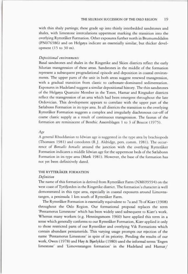
The limestone dominated sequence of theRytteråker Formation is approximately50 m thick in the type area; Kiær's tripartitedivision (7a, 7ba, 7b/?) was based both onfaunal composition and on varying proportions of limestone and calcareous shale
within the unit. A single complete typesection is not seen, but the basal stratotypeis deflned on the northern tip of Limovnstangen (NM691591) and reference sectionsthrough the middle and upper parts of theformation are exposed along both coasts ofthis peninsula. The top is seen under thebasal stratotype of the overlying Vik Formation on the limb ofa small syncline whoseaxis defines the northern coast of Limovns
tangen (NM695596).The basal stratotype of the Rytteråker
Formation shows a gradational development: interbedded thin to medium siltstones and shales of the Sælabonn Formation
show intercalations of limestone beds upwards. The base of the Rytteråker Formationis defined at the quantitative dominance oflimestone over siltstone (Fig. 11). Our formational base is therefore 5.5 m higher inthe section than the junction between 6c and7a defined by Kiær (1908) and correspondsto Kiær's bed XIV (Kiær 1908: ProfdtafelII). Limestones with pentamerids becomeincreasingly abundant through the basal10 m of the formation and grade upwardsinto thickly bedded biosparites in the middle 25 m of the unit (7ba of Kiær 1908).These beds are composed of flnely comminuted pentamerid and crinoid debris; smallbioherms are found at the top of this sequence throughout the Ringerike district(Hanken, Olaussen & Worsley 1979). Theuppermost 17 m of the formation (7b/3 ofKiær 1908) consist of planar limestone bedsand well-bedded calcareous nodules with
M Si lvt_L_llLI Sandstone±LLWif-LGIiJ Limestone
Fig. 11. A general section through thecomposite stratotypes of the Rytteråkerand Vik formations in Ringerike.

21THE SILURIAN SUCCESSION OF THE OSLO REGION
interbedded shales; the shale content increases towards the contact with theoverlying Vik Formation.
Other occurrences
Although the character and content of carbonates in the Rytteråker Formation varyfrom district to district, the unit can be traced throughout the Oslo Region. Theformation thins markedly northwards from the type area (Fig. 4); it thickenssoutheastwards and southwards to 65 m in Oslo/Asker and 80 m in Skien.
Exposures in Hadeland show a gradational contact with the SælabonnFormation, interbedded limestones and shales passing up into a thickly-beddedpentamerid biosparite unit. This is erosively overlain by interbedded limestonesand shales with both bioclastic and general carbonate content decreasing upwardsto the contact with the Ek Formation (see p. 25). The Rytteråker Formation thinsprogressively northwards through the Toten, Hamar and Ringsaker districts.Northernmost exposures at Torsæter Bridge in Brumunddalen (PN076586) showa 15 m-thick sequence of interbedded thin limestone beds, nodular horizons andshales.
Sequences assigned to the Rytteråker Formation share many common featuresin Asker, Oslo, Holmestrand and Skien. The base is gradational in all cases, eitherfrom the more sandy Sælabonn or more shaly Solvik Formations. Thin, finegrained limestones and shales occur in equal proportions in the lower parts of theunit in all these areas. Limestone beds thicken and coarsen upwards and shalecontent decreases into the middle and upper parts of the unit. The transition tothe overlying Vik Formation is often rapid, marked by the renewed developmentof interbedded limestones and shales.
Depositional environmentsThe Rytteråker Formation represents the establishment of relatively shallowcarbonate depositional environments throughout the Oslo Region at a time whenearlier source areas for coarse clastic material were submerged. The pentameridbiosparites of Hadeland and Ringerike represent high-energy shoals, with crestswhich may have been intermittently emergent (e.g. in Hadeland). Biohermaldevelopment on the upper surfaces of the shoals in Ringerike was probablyinitiated subsequent to a relative rise in sea-level which resulted in stabilizationof the shoals' highly mobile substrates. Other districts show more distal marinecarbonate sequences. However, in all these other districts a general shallowingupwards trend throughout the lower and middle parts of the formation is indicatedby an increase of better sorted and thick bedded biosparites at the expense of shaleand fine-grained limestones. Abundant pentamerids, corals and stromatoporoidstogether with benthic algae in all districts indicate that the formation was notdeposited in water of any great depth. The fauna is typical of Benthic Assemblage3 ofßoucot(l97s).
AgeOccurrences of the pentamerids Borealis and Pentamerus suggest a somewhat

D. WORSLEY, N. AARHUS, M. G. BASSETT, M. P. A. HOWe, A. MØRK& S. OLAUSSEN22
diachronous base for the Rytteråker Formation, ranging from the middle to lateIdwian in Ringerike and Hadeland to the late Idwian or early Fronian in centraland southern districts (Mørk 1981). The transition to the Vik and Ek Formationsis dated by the graptolite and brachiopod faunas of these overlying units (pp. 25and 27).
THE VIK FORMATION
Definttion
The development of this formation is best demonstrated in widespread but partialexposures throughout the Ringerike district. Easily accessible sections are seen inroadside cuttings immediately east of Vik (NM715609), prompting our use ofthis formational nåme. The formation generally corresponds to stage 7c of Kiær(1908) in the Ringerike, Oslo, Holmestrand and Skien districts and to Kiær's 7b/3and 7c in Asker. The Vik Formation is approximately 80 m thick in its type areaand shows a tripartite development with varying proportions of both red* andgreenish grey shales, maris and limestones. This tripartite development was thebasis of Kiær's (1908) subdivision into 7ca, 7c/3 and 7cy; the members proposedby Aarhus (1978) generally correspond to Kiær's subdivisions. We here modifythe provisional nomenclature of Aarhus and propose the establishment of theStorøysundet, Garntangen and Abborvika Members (in ascending order) in theVik Formation in its type area. A single type section for the formation cannot bedesignated but a basal stratotype is defined in a coastal section northwest ofRytteråker Farm (NM695596). This section shows the gradation from thinlyinterbedded limestones and greenish grey shales of the underlying Rytteråker Formation into predominantly red shales. The base of the Vik Formation isdefined at the sharp transition from limestone to shale dominance 4 m below thelowermost occurrence of red shales.
The base of the Storøysundet Member is, by definition, coincident with the baseof the Vik Formation. The basal stratotype displays 12.5 m of the member, buta total thickness of approximately 20 m in the type area of the Vik Formation issuggested by other coastal exposures around Storøysundet (NM6958). The redshales of the Storøysundet Member contain minor bioclastic limestone lenses, smallcalcareous nodules and occasional greenish grey shale interbeds. A diverse butsparse fauna includes crinoids, brachiopods, stromatoporoids and tabulate corals.
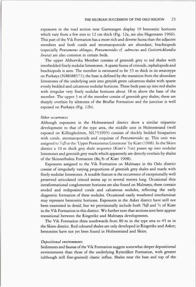
The middle 13 m of the Garntangen Member are exposed in the E6B roadsection near Garntangen (NM720609) on the coast of Steinsfjorden. The memberis also well exposed on the west coast of Storøya (NM690576 to NM694582)where its basal stratotype is defined. Its base is taken at the marked increase inlimestone interbeds 3 m above the uppermost red shales of the underlying unit.The Garntangen Member is approximately 25 m thick and consists of thinlybedded limestones and calcareous nodules with minor greenish grey maris. Fresh
* Red units, referred to here and subsequently, show colours varying from pale to dark reddishbrown, 10R5/4 to 10R3/4 of the Standard Rock Color Chart. Greenish grey beds correspond toSGY 6/1 of the same chart.
23THE SILURIAN SUCCESSION OF THE OSLO REGION
exposures in the road section near Garntangen display 19 bentonitic horizonswhich vary from a few mm to 12 cm thick (Fig. 12a, see also Hagemann 1966).This part of the Vik Formation has a more rich and diverse fauna than the adjacentmembers and both corals and stromatoporoids are abundant; brachiopods(especially Pentamerus oblongus, Pentameroides cf. subrectus and Costistrkklandialirata) are also common in certain beds.
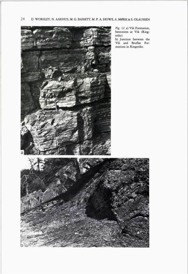
The upper Abborvika Member consists of greenish grey to red shales withinterbedded finely nodular limestones. A sparse fauna of crinoids, cephalopods andbrachiopods is seen. The member is estimated to be 35 m thick in its stratotypeon Purkøya (NM688571); the base is defined by the transition from the abundantlimestones of the underlying unit into greyish green calcareous shales with sparseevenly bedded and calcareous nodular horizons. These beds pass up into red shaleswith irregular very finely nodular horizons about 18 m above the base of themember. The upper 3 m of the member consist of greenish grey shales; these aresharply overlain by siltstones of the Bruflat Formation and the junction is wellexposed on Purkøya (Fig. 12b).
Other occurrences
Although exposures in the Holmestrand district show a similar tripartitedevelopment to that of the type area, the middle unit in Holmestrand (wellexposed on Killingholmen, NL753995) consists of thickly bedded biospariteswith corals, stromatoporoids and coquinas of Pentameroides sp. This unit wasassigned to 7c/? or the 'Upper Pentamerus Limestone' by Kiær (1908). In the Skiendistrict a 10 m thick grey shale sequence (Kiær's 7ca) passes up into nodularlimestones and greenish grey maris which apparently are directly overlain by shalesof the Skinnerbukta Formation (Ba/b of Kiær 1908).
Exposures assigned to the Vik Formation on Malmøya in the Oslo districtconsist of irregularly varying proportions of greenish grey shales and maris withfinely nodular limestones. A notable feature is the occurrence of exceptionally wellpreserved articulated crinoid stems up to several metres long. Occasional thinintraformational conglomerate horizons are also found on Malmøya; these containeroded and redeposited corals and calcareous nodules, reflecting the earlydiagenetic formation of these nodules. Occasional easily weathered interlaminaemay represent bentonitic horizons. Exposures in the Asker district have still notbeen examined in detail, but we provisionally include both 7b/3 and 7c of Kiærin the Vik Formation in this district. We further note that sections seen here appeartransitional between the Ringerike and Malmøya developments.
The Vik Formation thins southwards from 80 m in the type area to 45 m inthe Skien district. Red coloured shales are only developed in Ringerike and Asker;bentonites have not yet been found in Holmestrand and Skien.
Depositional environmentsSediments and faunas of the Vik Formation suggest somewhat deeper depositionalenvironments than those of the underlying Rytteråker Formation, with greater(although still fine-grained) clastic influx. Shales near the base and top of the
24 D. WORSLEY, N. AARHUS, M. G. BASSETT, M. P. A. HOWE, A. MØRK & S. OLAUSSEN
Fig. 12. a) Vik Formation,bentonites at Vik (Ringerike).b) Junction between theVik and Bruflat Formations in Ringerike.
THE SILURIAN SUCCESSION OF THE OSLO REGION 2 25
formation in Ringerike, Holmestrand and Skien contain faunas characteristic ofBenthic Assemblages 4 and 5 of Boucot (1975). The presence of abundant coralsand stromatoporoids (and associated benthic algae) typical of Benthic Assemblage
3 suggests the development of shallow mari banks in the Garntangen Member ofthe type area. A comparable unit in Holmestrand comprises a bioclastic shoal richin pentamerid and coral debris. Interpretations of the local red colour of the VikFormationa shales will be discussed further below (p. 50).
AgeOur correlation of the unit is based both upon occurrences of the brachiopods
Pentamerus, Pentameroides and Costistricklandia and on conodonts (R.J. Aldridgepers. comm. 1981). The brachiopods suggest that the Garntangen Member maybe equivalent to the C 4/ transition in the British sequence and conodontsindicate a slightly older (C 4) age for the base of the Vik Formation. A markedlydiachronous top is suggested, ranging from mid-C 5 equivalent in Ringerike to lateC 6 in Oslo (Fig. 5).
THE EK FORMATION
DefinitionThe formation's nåme was proposed by Skjeseth (1963); its nåme is derived from
Eksberget (PN087355) on the island of Helgøya in the Hamar district. The EkFormation is approximately 95 m thick in this type area; exposures assigned hereinto the Ek Formation are dominated by greenish grey to dark grey (often
graptoliferous) shales. We consider the Ek Formation to comprise all units assignedby Kiær (1908) to stage 7c in Hadeland, Toten, Hamar and Ringsaker and weretain Skjeseth's concept of the formation. Exposures in the Hadeland district showa transitional development to the Vik Formation but are more like the development of the Ek Formation in its type area; we therefore incorporate the informal
'Askilsrud shale' of Owen (1978) from Hadeland within our Ek Formation.Poor exposure and complex tectonics make a satisfactory definition of the
formation difficult. The type section proposed by Skjeseth (1963) along the 'newroad' (Kiær 1908: Fig. 100) at Eksberget is now largely overgrown, but no betterexposures are known at present. The base of 7c at Eksberget was described by Kiærat the transition from red nodular limestones and shales (here assigned to theRytteråker Formation) to greenish grey marly shales with darker grey graptoliferous horizons. Kiær noted approximately 95 m of such shales, the lower 65 m withnumerous graptolite horizons and the upper 30 m with a sparse shelly fauna. Thenature of the top of the Ek Formation is poorly understood on Helgøya. Theboundary with the overlying Bruflat Formation is best seen in this latter unit's basalstrå to type in the Toten district.
Other occurrences
Several small exposures are seen in the Ringsaker district around Torsæter Bridgein Brumunddalen (PN077584 to PN077589) approximately 20 km north of
Eksberget. Exposures there are highly tectonised and dark grey graptoliferous

26 D. WORSLEY, N. AARHUS, M. G. BASSETT, M. P. A. HOWE, A. MØRK & S. OLAUSSEN
shales with bentonites appear to have been seconda
rily reddened, probably during Permian times. Small
exposures of dark grey graptoliferous shales are also seen
in railway cuttings in theToten district around Bru
flat (NM875238 andNM877257).
NETBERG
(NM 842851)m10
S.sssag£ /, . M. crispusSrnrn 55>A
Sl 555 ABant"V
The base of the unit was
temporarily exposed in1977 in a trench at Stor-
Kyset (NN907297),2.5 km east of Reinsvoll in
Toten. The top of the Rytteråker Formation was mar
ked there by a 55 cm-thickred nodular limestone; this
was overlain by a 20 cmthick bentonite, followed bygreenish grey shales and
bentonites with some graptolite horizons. Exposures in
Hadeland (railway cuttingsat Netberg, NM842851and Gunstad, NM787844)indicate a similar thickness
to that seen in the type area
and a basal hypostratotype isdefined at Netberg (Fig.13). The base of the for
mation there is marked by
red shales overlying grey nodular limestones of the Rytteråker Formation. The lo
wer part of the Ek Formation consists of alternat
ing greenish grey and reddish shales with occasional
bentonitic horizons, sparseshelly fossils and occasional
thin black graptoliferous
ELL
5 / M. turriculatusLU
Bant.Bent.
W
rr
Bant
~V
0Rytteråker Fm
M 'Si
Fig. 13. Hypostratotype for the base of the Ek Formation inHadeland.
horizons. The remainder of the formation consists of greenish grey and red shaleswith finely nodular limestone horizons.
27THE SILURIAN SUCCESSION OF THE OSLO REGION
Depositional environmentsThe shales of the nothern districts were deposited in deep water environments distalto the prograding sandy deposits of the overlying Bruflat Formation. This foredeeppassed laterally southwards into shallower shelf environments with the mixedcarbonate and mud facies of the Vik Formation. The Hadeland exposures reflectthis transition, but are on balance more akin to the Ek Formation.
AgeRe-examination of Kiær's collections from his 'new road' on Helgøya and of newcollections from Toten suggest that the base of the Ek Formation in its type localityshould be correlated with the upper part of the crispus Biozone. Kiær (1908:416)recorded a 'Zone with Monograptus turriculatus and Petalograptus palmeus froma horizon 2.7 m above the base of the Ek Formation. We consider this zone to
contain a griestonensis Biozone fauna. Graptolites indicate a probable maximusBiozone age for the base of the Ek Formation in its hypostratotype in Hadeland.A turriculatus Biozone fauna is seen 5 m above the base of the formation. Two
poorer faunas 3 m and 3.5 m above the base suggest correlation with the maximusBiozone. A low crenulata Biozone age is suggested by graptolites from the top ofthe unit in Hadeland and Toten; sparse shelly faunas support this conclusion,indicating an equivalence to the C 5/C6 transition.
THE BRUFLAT FORMATION
DefinitionWe here adopt, define in detail and extend the use of the formational unit proposedby Strand & Størmer (1955) and Skjeseth (1963) for Toten, Hamar and Ringsaker,with its nåme derived from Bruflat (NN877256) in Toten. Kiær (1922)introduced the term 'Mariendal Series' for rocks which we assign to this unit inthe Ringsaker district; Kiær's term has never been widely used, whereas the BruflatFormation is now generally accepted. The informal term 'Mariendal Beds' wasused by Ramberg & Spjeldnæs (1978) for units which we assign to the BruflatFormation. We here geographically extend Skjeseth's (1963) formational conceptto include units assigned to 8a and 8b by Kiær (1908) in Ringerike and Hadeland.
Because of incomplete exposure and complex tectonics, a single type sectioncannot be designated. The type area around Bruflat shows a tightly folded andfaulted series of anticlines and synclines exposing various parts of the unit. Bestexposures are seen in several road and railway cuttings between Eina (NN875229)and Reinsvoll (NN884283). The base of the formation is defined in the southernend of a railway cutting (NN875238), 800 m north of Eina Railway Station. Acomposite section has not yet been satisfactorily established in the type area, buta thickness of 400-550 mis suggested (Fig. 14). The formation is characterisedby varying proportions of sandstones, siltstones and silty shales. The lower partof the formation in the type area consists of medium to thickly bedded very finecalcareous sandstones and silty shales, the base of the formation being defined bythe first occurrence of sandstones. Many of the sandstones have erosive bases, andshow planar lamination passing up into rippled tops. The upper 200 mof the
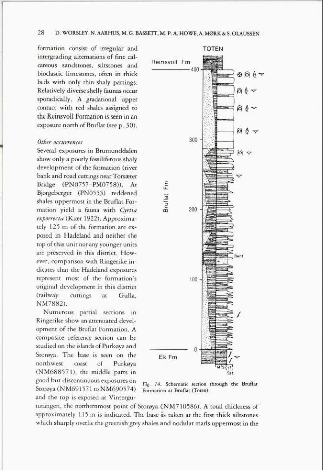
28 D. WORSLEY, N. AARHUS, M. G. BASSETT, M. P. A. HOWE, A. MØRK & S. OLAUSSEN
formation consist of irregular andintergrading alternations of fine calcareous sandstones, siltstones andbioclastic limestones, often in thickbeds with only thin shaly partings.Relatively diverse shelly faunas occursporadically. A gradational uppercontact with red shales assigned tothe Reinsvoll Formation is seen in an
exposure north of Bruflat (see p. 30).
Other occurrences
Several exposures in Brumunddalenshow only a poorly fossiliferous shalydevelopment of the formation (riverbank and road cuttings near TorsæterBridge (PN0757-PM0758)). AtBjørgeberget (PNO555) reddenedshales uppermost in the Bruflat Formation yield a fauna with Cyrtiaexporrecta (Kiær 1922). Approximately 125 m of the formation are exposed in Hadeland and neither thetop of this unit nor any younger unitsare preserved in this district. However, comparison with Ringerike indicates that the Hadeland exposuresrepresent most of the formation'soriginal development in this district(railway cuttings at Gulla,NM7882).
Numerous partial sections inRingerike show an attenuated development of the Bruflat Formation. Acomposite reference section can bestudied on the islands ofPurkøya andStorøya. The base is seen on thenorthwest coast of Purkøya(NM688571), the middle parts ingood but discontinuous exposures onStorøya (NM691571 to NM690574)and the top is exposed at Vintergu-
Fig. 14. Schematic section through the BruflatFormation at Bruflat (Toten).
tutangen, the northernmost point of Storøya (NM710586). A total thickness ofapproximately 115 m is indicated. The base is taken at the first thick siltstoneswhich sharply overlie the greenish grey shales and nodular maris uppermost in the
TOTEN
29THE SILURIAN SUCCESSION OF THE OSLO REGION
Vik Formation. The lower part of the Bruflat Formation (8a of Kiær, approximately 70 m thick) consists of a rhythmic sequence of shales (with shelly faunas)and more silty intervals; siltstones become more common upwards and 8b of Kiær(approximately 45 m thick) consists of medium-bedded siltstones and sandstoneswith bioclastic limestones and minor thin shales. We have not seen the desiccation
cracks reported by Størmer (1942) in the uppermost beds, but the top of the unitis marked by an erosive contact with the limestones of the overlying BraksøyaFormation.
Depositional environmentsThe formation shows a coarsening-upwards sequence in the type area, reflectinga large-scale coastal progradation into and over the graptoliferous shale environments of the Ek Formation. Distal storm generated sandstones in the lower partsof the Bruflat Formation are overlain by sediments typical of wave-dominatedclastic shelf environments with faunas assignable to Benthic Assemblage 4 ofBoucot (1975).
The formation shows a similar coarsening (and shallowing) upwards trend inRingerike to that seen in the type area. Storm-generated siltstones in the lower partof the unit (8a) were deposited below normal wave base in quiet muddyenvironments with faunas typical of Benthic Assemblage 5. The uppermost partof the formation (8b) shows abundant evidence of wave reworking, with faunaswhich can be assigned to Benthic Assemblage 4. The erosive contact with theoverlying Braksøya Formation is noteworthy: clasts of the Bruflat Formationasandstones found immediately above this contact may suggest emergence prior torenewed marine deposition in the carbonate dominated environments of theBraksøya Formation.
AgeSkjeseth (1-963) tentatively correlated his Bruflat Sandstone of the northernmostdistricts with stages 8 and 9 of more southerly areas and subsequent workers (e.g.Størmer 1967, Bjørlykke 1974a) generally assumed a Wenlock age for theformation although Bjørlykke noted that 'the age of the Bruflat Sandstone is notvery well defined'. Exposures both in the Ringerike and northern districts containgraptolite, conodont, brachiopod and coral taxa which are all characteristic of theuppermost Telychian (Q or crenulata Biozone). No diagnostic Wenlock faunalelements have yet been found, but we cannot yet rule out the possibility that theformation may extend into the basal centrifugus Biozone of the Wenlock.
Bassett & Rickards (1971) first presented revised datings of the formation inthe Ringerike district; however, their results were somewhat confusing as theapparent occurrence of cyrtograptids in beds assigned to 8a near Vik suggested aWenlock age for this locality in contrast to the Llandovery faunas of nearbyexposures of Bb. Although several cyrtograptid taxa have been described from theuppermost Llandovery (Jackson & Etherington 1969) it is now clear that thecyrtograptids in question did not originate from Ringerike. The graptolites foundin both 8a and 8b at Ringerike (Monograptus vomerina vomerina, M. parapriodon
30 D. WORSLEY, N. AARHUS, M. G. BASSETT, M. P. A. HOWE, A. MØRK & S. OLAUSSEN
and Retiolites geinitzianus ) clearly indicate correlation with the crenulata Biozone.Aldridge (1974) described an amorphognatboides assemblage of conodonts from8b in Ringerike; this conodont assemblage ranges into the early Wenlock, but thetotal fauna, including the brachiopods Costistricklandia lirata lirata, Cyphomenoidea wisgoriensis, Protomegastrophia undata and the rugose coral Palaeocyclusporpita suggests a Telychian age.
Both conodont and brachiopod shelly faunas found in the upper parts of theBruflat Formation in its type area contain the same key elements as listed above,thus suggesting a close correlation with Ringerike (Fig. 4). The reddened 'Cyrtiashales' found by Kiær (1922) on Bjørgeberget in the Ringsaker district lackdistinctive faunas. No typical Llandovery faunal elements occur, however, andthese beds (probably the youngest parts of the Bruflat Formation preserved in theOslo Region) may extend into the early Wenlock.
THE REINSVOLL FORMATION
Definition
This unit has not been described previously and we have identified it with certaintyonly in the Reinsvoll area of the Toten district. The Reinsvoll Formation is notassigned to any of the groups described herein at this stage, but is provisionallydescribed here in view of its potential regional significance. The ReinsvollFormation consists of poorly exposed red shales of unknown total thickness. Itsbasal stratotype is exposed on a farm track between Highway 4 and Berget, onthe eastern bank of the Hunselv river in Toten (NN876269). The lower 21 m ofthe Hunselv section consist of calcareous sandstones with bioclastic interbeds and
shaly partings; these beds are assigned to the Bruflat Formation and the upper10 m of this sequence are reddened. These are overlain by approximately 15 mof monotonous red shales which we here assign to the Reinsvoll Formation, butthe nature of the contact with the underlying beds is obscure. Similar red shaleshave also been seen in trenches dug for a new housing development immediatelysouth of Reinsvoll (NN886279). Loose blocks are also present in drift above anearby road-cutting. No definite equivalents of the Reinsvoll Formation have yetbeen found in Hadeland. In the Hamar and Ringsaker districts the Bruflat Formationis unconformably overlain by rhomb-porphyry lavas and by the BrumunddalenSandstone (Kiær 1922, Rosendahl 1929) of probable Permo-Triassic age. Thejunction, seen at several places on Bjørgeberget (PN0555) is poorly exposed, andthe presence of the Reinsvoll Formation there can neither be confirmed nor rejected.
Depositional environments and age of the Reinsvoll Formation are uncertain.Although the formation is certainly younger than the underlying Bruflat Formation, no identifiable fossils have yet been found.
THE SKINNERBUKTA FORMATION
Definition
This formationa nåme is derived from Skinnerbukta, a bay on the northwesterncoast of Malmøya in the Oslo district. The Skinnerbukta Formation correspondsto stages 8a and 8b of Kiær (1908) in Oslo, Asker, Modum, Holmestrand and
THE SILURIAN SUCCESSION OF THE OSLO REGION 3 31
Skien. In spite of some tectonic disturbance a reasonably complete type section canbe defined in cliffs on the east coast of Skinnerbukta (NM894381). The unit is
approximately 80 m thick in its type section and consists of dark grey graptoliferous shales.
The base is defined immediately above a sequence of shales with both nodularand continuous limestone interbeds which constitute the base of the exposure.Although the nodules are larger, and the limestone beds thicker, than those usuallyseen in the Vik Formation, this sequence is assigned to that formation. Theoverlying dark grey shales of the Skinnerbukta Formation contain occasional thinmarly horizons which are sometimes slightly bioturbated. The total calcareouscontent of the formation increases upwards and its upper parts consist of somewhatpaler calcareojus shales. These uppermost beds also show an increasing abundanceof limestone interbeds and the gradational top of the unit is defined by the base
of the overlying Malmøya Formation (p. 36). Graptolites and hyolithids dominatethe fauna of the formation in the type section; some rare shelly elements have been
found, including scattered lingulids, gastropods, crinoids and small specimens ofEoplectodonta transversalis.
Other occurrences
The formation is also exposed at several localities in Asker, Holmestrand andSkien. Exposures at Bærum in the Asker district (Øverland, NM876449, JongNM846404 and Gjettum NM850022) suggest a thickness of 90 m; shales therecontain both graptolites and low diversity benthic faunas. Metamorphosedexposures on Kommersøya (NL750990) and at Sando (NM740013) in Holme
strand show a more diverse benthic fauna with several brachiopod and trilobitetaxa, while graptolites are rare. Exposures in Skien (e.g. around Kapitelberget,NL367628) mark the continuation of this ecological gradient as benthic faunasthere show a moderate diversity and approach a composition similar to that seenin the Bruflat Formation of Ringerike. Thin limestones are common, and formdistinct horizons (often bioclastic lenses) in the upper part of the unit. However,the absence of coarse clastic material leads to the assignment of the Skien sequenceto the Skinnerbukta, rather than to the Bruflat Formation.
Depositional environmentsIn its type area, the Skinnerbukta Formation's shales were deposited in low-energy,
usually anaerobic environments. The occasional presence of bioturbation and of(highly restricted) benthic elements suggests periodic flushing of a generally anoxicmud bottom. Several of these elements may represent either epiplanktic taxadrifted into the area attached to floating algae or possible giant spat. The only
clearly benthic element is Eoplectodonta transversalis; the few individuals foundare small and apparently stunted, suggesting restricted bottom conditions adverseto shelly colonisation. Bioturbation and benthic diversity increase upwards in theformation in the type area, suggesting a generally shallowing trend. Benthic faunaldiversity also progressively increases from Oslo, through Asker and Holmestrand,
to Skien and faunas found there may be assigned to Benthic Assemblages 5 to 4of Boucot (1975).
32 D. WORSLEY, N. AARHUS, M. G. BASSETT, M. P. A. HOWE, A. MØRK & S. OLAUSSEN
AgeThe faunal evidence suggests a marked regional diachroneity of the SkinnerbuktaFormation's lower and upper boundaries, which became older from Malmøya toSkien. Graptolite faunas in the type section suggest that the base of the formationthere is approximately correlative with the Llandovery/Wenlock boundary,although the basal 10 m (8a of Kiær 1908) may possibly be assigned to the latestLlandovery crenulata Biozone. Revision of the correlation of Bassett & Rickards(1971) suggests that elements typical of the Wenlock centrifugus, murchisoni andriccartonensis graptolite Biozones are found upwards through the formation onMalmøya and its upper parts extend into the rigidus Biozone. Both the base andtop of the Skinnerbukta Formation become progressively older southwards, andbenthic faunas near the top of the formation in the Skien district contain elementswhich, as noted under our discussion of the Bruflat Formation, are typical of theuppermost Llandovery (e.g. Costistrkklandia lirata lirata, Palaeocyclus porpitaand Isorthis mckenzii).
Comparison with Ringerike suggests that the Skinnerbukta Formation in itstype area is laterally equivalent to the (combined) uppermost parts of the BruflatFormation, the entire Braksøya Formation and the lowermost parts of theSteinsfjorden Formation of the latter district. This complex facies mosaic will befurther discussed below.
THE HOLE GROUP
The group's nåme is based on the municipality of Hole in the Ringerike district;the group comprises the carbonate-dominated sequences which constitute theupper parts of the marine Silurian succession in the central, western and southerndistricts of the Oslo Region. These sequences are assigned to our new Braksøya,Malmøya and Steinsfjorden Formations. Representatives of the group are notpreserved in the northern districts of the region.
The base of the group is generally coincident with the base of 8c of Kiær (1908).In Ringerike, Modum and Skien this corresponds to the base of our BraksøyaFormation and the boundary stratotype for the base of the Hole Group is thatdefined herein for the Braksøya Formation in Ringerike. The junction withunderlying Bærum Group is sharply defined there. In other districts (Oslo, Askerand Holmestrand) the group's base corresponds to the base of our MalmøyaFormation, with a gradational lower junction. The composite thickness of thegroup is 275 m in Ringerike and 240 m in Asker, thinning southwards to 120 min Holmestrand and 170 m in Skien. The group's top is not preserved in the Oslodistrict, but its upper boundary to the Ringerike Group in other districtscorresponds to the gradational junction between stages 9 and 10 of Kiær (1908).
The Hole Group is correlated with most of the Sheinwoodian and Homerian.Its base is diachronous, younging from Skien and Ringerike to the Oslo districtand its top is placed somewhat below the Homerian/Gorstian boundary in theRingerike district. Several workers have suggested large-scale regional diachroneityof the junction between the Hole Group and the overlying Ringerike Group (e.g.

THE SILURIAN SUCCESSION OF THE OSLO REGION 33
Spjeldnæs 1967, Bjørlykke1974 and Ramberg & Spjeldnæs 1978). We still lack precise biostratigraphical documentation of this relationship(see p. 41).
THE BRAKSØYA FORMATION
DefinitionThe formation is best demonstrated on the west coast of
Braksøya (NM727610) inRingerike, where a completetype section can be designated(Fig. 15); the formation is27 m thick there and consists
of a complex carbonate development with minor maris andshales. The Braksøya Formation corresponds to 8c and8d of Kiær (1908) in Ringerike, Modum and Skien. Weprovisionally subdivide theformation into two informal
members, pending the resultsof Works in progress by S.O.and N.M. Hanken.
Pseudo. CaS04
The base of the BraksøyaFormation in its type section isclearly deflned by limestoneswhich overlie the eroded topsurface of the Bruflat Formation. Small sandstone and
shale clasts from the underlying formation are seen in these
Eu_
D
DD
M Si.vf f m, Sandstone
S i W ,P i G i B , Limestone
Fig. 15. The type section of the Braksøya FormationRingerike.
basal limestones. A lower biohermal member is 17 m thick and is characterised
by thinly bedded maris with massive biomicrite and biolithite structures (up to7 m high and 15 m wide) which we interpret as small patch reefs (Fig. 16, cf.Kiær 1908, Fig. 19c). These contain algae, bryozoans, tabulate corals, stromatoporoids and other problematical organisms both as framework and bindingelement in the reefs' structure (Hanken, Olaussen & Worsley 1979). The patchreefs pass both laterally and vertically into maris of variable thickness whichcontain a varied brachiopod fauna, and occasional horizons show large, currentoriented, rugose corals (Whitaker 1965). Scattered pseudomorphs after celestiteor gypsum are also seen in the marly sequence. The upper part of this member

34 D. WORSLEY, N. AARHUS, M. G. BASSETT, M. P. A. HOWE, A. MØRK & S. OLAUSSEN
Fig. 16. Biohermal development in the Braksøya Formation at Braksøya, Ringerike. Inset showsdetail from the patch reefs.

THE SILURIAN SUCCESSION OF THE OSLO REGION 3 35
consists of a 3.5 m thick, black, bituminous shale with in situ tabulate corals and
stromatoporoids; individual colonies over 1 m 3 in size are present.
The upper, well-bedded member is 10 m thick in the formation's type sectionand consists of thickly bedded limestones with marly partings and occasionaldesiccation cracks. Thinly (algal?) laminated limestones (with fenestral fabrics and
pseudomorphs after evaporite nodules), coral biostromes and oncolitic biosparitesalso occur. The top of the Braksøya Formation is taken below the first appearance
of thinly interbedded limestones and shales here assigned to the overlyingSteinsfjorden Formation.
Other occurrences
The complex and varied development of the Braksøya Formation is welldemonstrated in several exposures elsewhere in the Ringerike district (Geitøya
NM6956, Storøya NM7057 and Sønsterud NM7251). Wherever it is exposed,the contact with the underlying Bruflat Formation is erosive. As might be expected,the patch reefs and maris in the lower member of the formation show variable localdevelopments, and in some exposures this member consists of only one of these
lithofacies.
Exposures in Modum and Skien are provisionally included in the BraksøyaFormation. A lower biohermal member is well developed in both districts(especially at Kapitelberget, NL367628 in Skien). However, the upper part of theformation in both districts contains interbedded limestones and shales similar to
those assigned to the Malmøya Formation in the Holmestrand and central districtsand unlike those of the upper member at Ringerike.
Depositional environmentsAll exposures assigned to the Braksøya Formation indicate the establishment of
marginal marine carbonate depositional environments following a short (andbiostratigraphically indefinable) period of erosion (and Pemergence) near the
Llandovery/Wenlock boundary. The fauna and flora of the patch reefs indicateshallow, clear water, marine environments; however, both the restricted character
of the flora and fauna and the occurrence of evaporites in mari sequences at
Ringerike suggest periodic hypersaline conditions. Desiccation cracks and evaporitic pseudomorphs seen in the upper parts of the formation in the type area also
indicate intra/supratidal depositional environments. Such features have not beenobserved in the Modum and Skien districts and this suggests deposition in moredistal marine environments. Faunas are comparable to those assigned to BenthicAssemblages 2 and 3 by Boucot (1975).
AgeBrachiopods, corals and ostracodes seen in the type section of the BraksøyaFormation contain no diagnostic Llandovery elements, and the base of theoverlying Steinsfjorden Formation contains brachiopods (including Eocoelia
angelini) with a Sheinwoodian {riccartonensis Biozone) age. Faunal elementstherefore suggest a low Sheinwoodian { ptt-riccartonensis Biozone) age similar to

36 D. WORSLEY, N. AARHUS, M. G. BASSETT, M. P. A. HOWE, A. MØRK & S. OLAUSSEN
that of the Upper Visby Beds of Gotland (Bassett & Cocks 1974). The occurrenceoiEocoelia angelini in the upper part ofthe Braksøya Formation in the Skien district
suggests a somewhat later transition there to beds assigned to the SteinsfjordenFormation. Thus, the Braksøya Formation in its type area is considered to be a timeequivalent of the Skinnerbukta Formation in the Holmestrand and central
districts. The development in Skien overlies beds assigned to the Skinnerbukta
Formation; the top of the Braksøya Formation in this district is approximatelycorrelative with the junction between the Skinnerbukta and Malmøya Formationsof Holmestrand and the central districts (Fig. 5).
THE MALMØYA FORMATION
Definition
Kjerulf (1857) introduced the term 'Malmøya Limestone and Shale' for exposuresof his stage 8 on Malmøya in the Oslo district. Kiær (1908) assigned the lower(more shaly) part of Kjerulfs's unit to 8c and the upper massive limestones to 8d;he applied the term 'Malmøya Limestone' both to the latter limestones and to units
he assigned to 8d in Asker, Holmestrand and Skien. Kiær's practice was alsofollowed by Strand & Størmer (1955) in their definition of the 'MalmøyaLimestone'. Our redefinition and use of the Malmøya Formation is based onKjerulf s original designation; both Kiær's and subsequent applications of thisterm only to the upper part of Kjerulf s unit are rejected. Our use of the MalmøyaFormation therefore generally corresponds to Stages 8c and 8d of Kiær (1908) inOslo, Asker, Eiker and Holmestrand. Only the lower and middle parts of theMalmøya Formation are exposed on Malmøya and these represent the youngestSilurian strata preserved in the Oslo district. The basal stratotype defined onMalmøya (NM985382) is therefore supplemented with a parastratotype from
Gjettum in the Asker district (NM875449). The formation is approximately 35 mthick at Gjettum (Fig. 17), and both its base (Malmøya) and top (Gjettum) aregradational. The base is defined on Malmøya at the first development ofcontinuous limestone beds above the graptoliferous shales with marly horizons ofthe underlying Skinnerbukta Formation. The lower part of the formation (8c ofKiær) shows varying proportions of continuous, nodular and lenticular limestonebeds, all with interbedded shales. These grade up into thickly to massively bedded
biosparitic limestones and faunal diversity increases correspondingly. The lowerand middle parts of the formation at Gjettum show a similar development to bedspreserved on Malmøya; the massive limestones seen in both areas grade upwardsin the Gjettum section into coral and stromatoporoid biostromes and biosparrudites high in the formation. These show a gradational contact with the thinlyinterbedded micritic limestones and shales (with a more restricted fauna) which
we assign to the overlying Steinsfjorden Formation.
Otber occurrences
The Malmøya Formation is also exposed on Kommersøya (NL7499) and at Sando(NM738015) in the Holmestrand district; its base there is obscure and the junctionwith the underlying Skinnerbukta Formation may be faulted. As in the type area,
THE SILURIAN SUCCESSION OF THE OSLO REGION 37
GJETTUM
NM 875449
Fig. 17. Parastratotype of the Malmøya Formationat Gjettum (Asker district).
the unit shows a gradation upwardsfrom interbedded limestones and
shales into thickly bedded limestoneswith coral biostromes and biosparrudites.
Depositional environmentsThinly-bedded limestones in the lower parts of the formation are interpreted as storm-generated units deposited distally to the carbonate shoalswhich are represented by the overlyingthickly bedded biosparites and coralbiostromes. The entire sequence reflects progressively shallowing depositional environments in the Holmestrand and central districts, withprogradation of carbonate shoals overthe basinal shales of the underlyingSkinnerbukta Formation. High energy environments on the shoals aresuggested by the reworked corals ofthe biostromes; however, all the unitsassigned to the formation were deposited in subtidal environments and no
evidence of emergence is seen. Thefauna is reminiscent of Benthic As
semblages 4 to 3 of Boucot (1975).
AgeThe base of the Malmøya Formationis younger than the riccartonensis(possibly early rigidus) Biozone graptoliferous shales in the upper parts ofthe Skinnerbukta Formation. Faunalelements within the Malmøya Formation have a general, but nondiagnostic Wenlock aspect. The brachio-
pod Eocoelia angelini occurs in the lower parts of the formation (8c) at Gjettumand on Kommersøya. This brachiopod suggests a correlation with the mid-Sheinwoodian riccartonensis Biozone (Bassett & Rickards 1971, Bassett & Cocks1974, Bassett 1979). Available evidence therefore suggests a diachronous base forthe Malmøya Formation, ranging from the riccartonensis Biozone in Holmestrandand Asker to the rigidus Biozone on Malmøya. Basal units in Holmestrand andAsker (8c) are considered to be time equivalents to the upper parts of the Braksøya
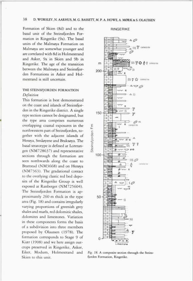
38 D. WORSLEY, N. AARHUS, M. G. BASSETT, M. P. A. HOWE, A. MØRK & S. OLAUSSEN
Formation of Skien (8d) and to the
basal unit of the Steinsfjorden Formation in Ringerike (9a). The basalunits of the Malmøya Formation on
Malmøya are somewhat younger andare correlated with 8d in Holmestrand
and Asker, 9a in Skien and 9b in
Ringerike. The age of the transition
between the Malmøya and Steinsfjorden Formations in Asker and Holmestrand is still uncertain.
Ssstf© #y celestlte
iii \7 "Cf celestite
THE STEINSFJORDEN FORMATION
DefinitionThis formation is best demonstrated
on the coast and islands of Steinsfjor
den in the Ringerike district. A singletype section cannot be designated, butthe type area comprises numerous
overlapping coastal exposures in thenorthwestern part of Steinsfjorden, together with the adjacent islands ofHerøya, Småøyene and Braksøya. Thebasal stratotype is defined at Loretan
gen (NM728637) and representativesections through the formation are
seen northwards along the coast toBrattstad (NM3668) and on Herøya(NM7363). The gradational contact
to the overlying clastic red bed deposits of the Ringerike Group is wellexposed at Ranberget (NM725604).
The Steinsfjorden Formation is approximately 260 m thick in the typearea (Fig. 18) and contains irregularlyvarying proportions of greenish greyshales and maris, red dolomitic shales,dolomites and limestones. Variation
in these components forms the basisof a subdivision into three members
proposed by Olaussen (1978). The
formation corresponds to Stage 9 ofKiær (1908) and we here assign outcrops preserved in Ringerike, Asker,Eiker, Modum, Holmestrand andSkien to this unit.
ceiesMf
Fig. 18. A composite section through the Steinsfjorden Formation, Ringerike.
RINGERIKE
$$$1? celestite
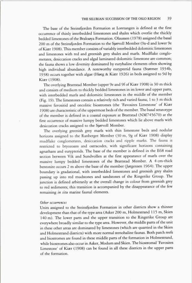
39THE SILURIAN SUCCESSION OF THE OSLO REGION
The base of the Steinsfjorden Formation at Loretangen is defined at the firstoccurrence of thinly interbedded limestones and shales which overlie the thicklybedded limestones of the Braksøya Formation. Olaussen (1978) assigned the basal200 m of the Steinsfjorden Formation to the Sjørvoll Member (9a-d and lower 9eof Kiær 1908). This member consists ofvariably interbedded dolomitic limestonesand limestones with red and greenish grey shales and maris. Mudflake conglomerates, desiccation cracks and algal laminated dolomitic limestone are common;the fauna shows a low diversity dominated by euryhaline elements often showinghigh individual abundance. A noteworthy eurypterid fauna (Størmer 1934b,1938) occurs together with algae (Høeg & Kiær 1926) in beds assigned to 9d byKiær (1908).
The overlying Brattstad Member (upper 9e and 9f of Kiær 1908) is 30 m thickand consists of medium to thickly bedded limestones in its lower and upper parts,with interbedded maris and dolomitic limestones in the middle of the member
(Fig. 19). The limestones contain a relatively rich and varied fauna; 1 to 3 m thickmassive favositid and oncolitic biostromes (the 'Favosites Limestone' of Kiær1908) are characteristic of the uppermost beds of the member. The basal stratotypeof the member is defined in a coastal exposure at Brattstad (NM745670) at thefirst occurrence of massive lumpy bedded limestones which lie above maris withdesiccation cracks assigned to the Sjørvoll Member.
The overlying greenish grey maris with thin limestone beds and nodularhorizons assigned to the Ranberget Member (30 m, 9g of Kiær 1908) displaymudflake conglomerates, desiccation cracks and ripple marks. The fauna isrestricted to bryozoans and ostracodes, with significant horizons containingagnathans and eurypterids. The base of the member is defined in the E6B roadsection between Vik and Sundvollen at the first appearance of maris over themassive lumpy bedded limestones of the Brattstad Member. A 4 cm-thickbentonite occurs 2 m above the base of the member (Jørgensen 1964). The upperboundary is gradational, with interbedded limestones and greenish grey shalespassing up into red mudstones and sandstones of the Ringerike Group. Thejunction is defined arbitrarily at the overall change in colour from greenish greyto red sediments; this transition is accompanied by the disappearance of the fewremaining in situ marine faunal elements.
Other occurrences
Units assigned to the Steinsfjorden Formation in other districts show a thinnerdevelopment than that of the type area (Asker 200 m, Holmestrand 115 m, Skien140 m). The lower parts and the upper transition to the Ringerike Group areeverywhere broadly similar to the type area. However, the middle parts of the unitin these other areas are dominated by limestones (which are quarried in the Skienand Holmestrand districts) with more normal stenohaline faunas. Both patch reefsand biostromes are found in these middle parts of the formation in Holmestrand,while biostromes also occur in Asker, Modum and Skien. The biostromal 'FavositesLimestone' of Kiær (1908) can be found in all these districts in the upper partsof the formation.
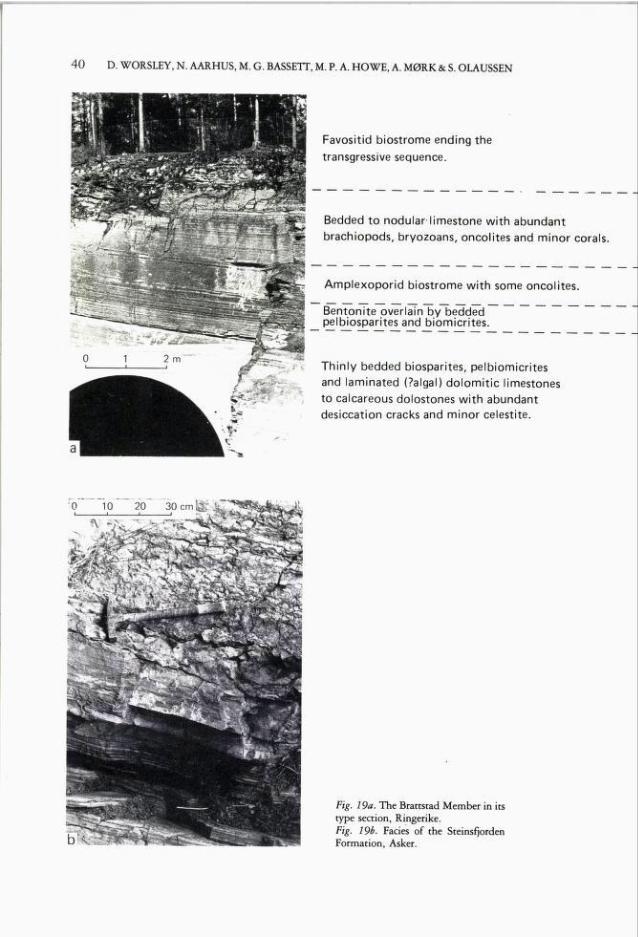
40 D. WORSLEY, N. AARHUS, M. G. BASSETT, M. P. A. HOWE, A. MØRK & S. OLAUSSEN
4H ' -V ' Bl • *»' "
Favositid biostrome ending the
transgressive sequence.
Bedded to nodular limestone with abundant
brachiopods, bryozoans, oncolites and minor corals
Amplexoporid biostrome with some oncolites.
Bentonite overlain by beddedpelbiosparites and biomicrites.
Thinly bedded biosparites, pelbiomicrites
and laminated (?a Iga I) dolomitic limestonesto calcareous dolostones with abundantdesiccation cracks and minor celestite.
10 20 30cmfe;
Fig. 19a. The Brattstad Member in itstype section, Ringerike.Fig. 19b. Facies of the SteinsfjordenFormation, Asker.
THE SILURIAN SUCCESSION OF THE OSLO REGION 41
Depositional environmentsIn its type area the formation contains mixed carbonate and mud lithofaciesassociations mostly deposited in supratidal, intertidal and restricted subtidalenvironments. Rhythmic lithological variations seen within the unit representsmall-scale transgressive and regressive events, the transgressive periods markedby the deposition of thin biostromal banks. The presence of early diageneticdolomite and celestite suggests arid conditions in the type area (Olaussen 1978& 1981b). The lower and upper parts of the formation in other districts were alsodeposited in peritidal environments, but the unit's middle parts suggest more opensubtidal conditions which permitted the development of biostromes and patchreefs with a highly diverse flora and fauna on marginal areas of the inner shelf.The favositid bioherms and biostromes seen in the upper part of the formationin all districts mark a larger scale transgressive episode; for a short time this resultedin normal marine conditions in all districts, prior to a regional regression whichculminated in the deposition of the overlying red beds of the Ringerike Group.
AgeSequences which we assign to the Steinsfjorden Formation were originallycorrelated with the Ludlow. However, studies of agnathans (Heintz 1969),ostracodes (Martinsson 1969) and thelodonts (Gross 1967, Turner & Turner1974) suggest that the transition from marine to red bed deposition at the top ofthe Steinsfjorden Formation approximates to the Wenlock/Ludlow boundary,thus placing the entire formation within the Wenlock. The age of the base of theSteinsfjorden Formation was first clarified by Bassett & Rickards (1971) using theoccurrence of the brachiopod Eocoelia angeIim. We have already noted themid-Sheinwoodian age of this brachiopod: its occurrence in the lower parts of theSteinsfjorden Formation in Ringerike and in varying parts of underlying units inother districts suggests that the base of the formation youngs progressively fromRingerike through Holmestrand and Skien to Asker (Fig. 5). We thereforeconsider the lower parts of the Steinsfjorden Formation in its type area to be timeequivalents of the entire Malmøya Formation of Asker and of the upper parts ofthe Malmøya and Braksøya Formations in Holmestrand and Skien respectively.
The ostracode and thelodont faunas described from the upper beds (9g) of theSteinsfjorden Formation in Ringerike (Gross 1967, Martinsson 1969, Turner &Turner 1974) suggest a correlation with the Halla Beds of Gotland (Gross 1968).Recent work on Gotland (Bassett et al. in press.) suggests that the Halla Formationlies within the nassa Biozone. The youngest marine faunas of the SteinsfjordenFormation may therefore have a slightly earlier age than that suggested near to theWenlock/Ludlow boundary by among others Turner & Turner (1974:190). Wehave as yet little faunal evidence to date the upper parts of the SteinsfjordenFormation in other districts. The youngest faunas found at Holmestrand (in 9d)have a Sheinwoodian character, and faunas elsewhere from higher in the formationhave a general Wenlock aspect. We have therefore no biostratigraphic data as yetto test the sedimentological models of Spjeldnæs (1966) and Bjørlykke (1974)which suggest a regionally diachronous contact with the overlying Ringerike
42 D. WORSLEY, N. AARHUS, M. G. BASSETT, M. P. A. HOWE, A. MØRK & S. OLAUSSEN
Group, younging from Ringerike towards Asker and the south. Studies ofthelodonts found in the Asker district (S. Turner pers. comm. 1982) may resolvethis question.
THE RINGERIKE GROUP
Red beds assigned to the Ringerike Group have a conformable and gradationalcontact with the Steinsfjorden Formation in the Ringerike, Asker, Holmestrand,Eiker and Skien districts. The Ringerike Group is in turn uncomformably overlainby sediments (the Asker Group of Dons & Gyory 1967, Henningsmoen 1978)and/or lavas. The Asker Group was previously thought to be Permian in age, butfusulines found recently have a mid/late Carboniferous aspect (Olaussen 1981a).
Kiær (1908) assigned the red beds of Ringerike to stage 10 and suggested aDevonian age. Subsequent work concentrated on the remarkable fauna ofagnathans, crustaceans and eurypterids in the lower parts of this red bed sequence(Kiær 1911, Kiær 1924, Størmer 1934a, Størmer 1935, Heintz 1939 (andHanken & Størmer 1975). Agnathans were also described from similar red bedson Jeløya on the eastern side of outer Oslofjorden in the Holmestrand district (Kiær1931, Heintz 1974). The entire red bed development was for many years assignedto stage 10 in most works (e.g. review of Henningsmoen 1960), but later workerscalled the sequence either the Ringerike Formation (Spjeldnæs 1966), theRingerike Sandstone Series (Whitaker 1966) or the Ringerike Sandstone (Heintz1969). Knowledge of the lithostratigraphy and sedimentology of this red beddevelopment has been greatly increased by the work of Whitaker (1964, 1965,1966, 1980), Turner (1974a, b, c) and Turner & Whitaker (1976). These studieswere chiefly directed towards the Ringerike district, although Turner (1974a) andTurner & Whitaker (1976) also presented information on Asker and Holmestrand.
Turner (1974a) proposed the Ringerike Group to embrace all red bed unitsearlier assigned to stage 10. The group comprises an approximately 1,250 m thicksequence of red siltstones and sandstones in its type area in the Ringerike district.Turner also defined the Sundvollen (lower 500 m) and Stubdal, (upper 750 m)Formations within the Ringerike Group in its type area. The type section of theSundvollen Formation on the western slopes of Kroksund (NM7259) consistsmostly of red siltstones and sandstones arranged in fluvial upwards finingsequences. Interbedded marine mudstones and limestones of tidal inlet originsuggest coastal plain to estuarine environments. The Stubdal Formation's typesection in Stuvdal (NM7766) is dominated by sandstones (with intraformationalconglomerates), reflecting deposition by braided stream systems prograding overthe more fine-grained deposits of the underlying formation. Palaeocurrentindicators and the petrology of sandstones in fyoth formations suggest drainagesystems with sources in the developing Caledonides to the north and northwestof the present Ringerike district (Turner & Whitaker 1976). The maximumpreserved thickness of the Stubdal Formation is seen at Stuvdal; when tracedsouthwards the preserved thickness of the formation decreases rapidly because ofpre-Carboniferous tilting and erosion.
43THE SILURIAN SUCCESSION OF THE OSLO REGION
Units assigned by Turner (1974a) to the Ringerike Group in the Asker districtat Kolsås show a broadly similar stratigraphy to that of the type area, althoughthe total thickness of the group there is only 500 m. The Sundvollen Formationis 100 m thick and consists of siltstones and mudstones with minor sandstones;
there is no clear organisation of these components. An estuarine environment wassuggested by Spjeldnæs (1966) and Turner (1974a) also noted that the transitionfrom marine to red beds was more gradual at Kolsås than in Ringerike. TheStubdal Formation consists of finer grained sandstones than those seen in the typearea, although the mineralogical content is similar in both Ringerike and Asker.Thus the entire Ringerike Group in Ringerike and Asker is regarded as a southto southeastwards prograding unit.
The Holmestrand Formation of Turner (1974a) is exposed on both the east(Jeløya) and west coast of outer Oslofjorden in the Holmestrand district. Turnerdefined the type section of the formation between Engenes and Smørstein(NL723999) in the Holmestrand area. An approximately 600 m thick sequenceis dominated by medium-grained sandstones with extraformational conglomerateclasts, a development which Turner & Whitaker (1976) contrasted with the redbeds seen in the Ringerike district. They suggested deposition of the HolmestrandFormation's sandstones by braided streams draining westwards, citing elastcomposition and sandstone mineralogy as suggesting the erosion of Precambrianbasement complexes to the east of the Oslo graben. This interpretation contrastswith the results of other workers (F. Andreasen pers. comm. 1978) which suggestdeposition of the Holmestrand Formation on coastal floodplains with palaeoccurrents from the northwest. An explanation of these conflicting views is suggestedby recent studies of the junction between the Ringerike and Asker Groups(Olaussen 1981a); these indicate that some of the red beds assigned by Turner &Whitaker to the Holmestrand Formation may in fact be Carboniferous in age.More detailed work is clearly necessary; and studies of the metamorphosed300 m-thick sequence generally assigned to the Ringerike Group in Eiker andSkien are also needed before reliable palaeogeographical interpretations can bepresented.
Early descriptions of the agnathan and arthropod faunas in beds assigned to thebasal parts of the Ringerike Group in its type area followed Kiær's (1911)assumption of a Downtonian age. Later works (Heintz 1969:25, Turner & Turner1974:190) suggested an early Ludlow age for the same units. However, as theyoungest marine faunas found in the Steinsfjorden Formation are now thought toindicate a nassa Biozone age, the lowermost red beds could be also of Wenlockage. Turner (1974a) considered the Holmestrand Formation to be age equivalentto the Stubdal Formation of Ringerike, but we have no data on the age of themarine to red bed transition in Holmestrand. A fossiliferous horizon found in the
lower parts of the Holmestrand Formation at Smørstein by Prof. G. Henningsmoen contains a plectambonitacean brachiopod and a single poorly preservedchitinozoan with 'a general Ludlow aspect' (S. Laufeld pers. comm. 1980).Agnathans found on Jeløya (NL953923) suggest an early Downtonian age (Heintz1974); although these finds are from the lower parts of the 230 m-thick exposed

44 D. WORSLEY, N. AARHUS, M. G. BASSETT, M. P. A. HOWE, A. MØRK & S. OLAUSSEN
sequence of the Holmestrand Formation, we do not knowhow far they are abovethe marine to red bed transition. Present evidence, albeit sparse, doesnot suggest any substantial diachroneity between the Ringerike and Holmestranddistricts and we provisionally consider the Holmestrand Formation to be a lateralequivalent of the Sundvollen Formation of Ringerike (Fig. 5).
SynthesisOur correlations and environmental interpretations of the proposed formationalunits permit a better understanding of the palaeogeographical evolution of theOslo Region in the Silurian. This review discusses earlier work in the context ofour results and presents general models which will be tested and refined in thecourse of studies now in progress. At this stage we present general nonpalinspasticlithofacies distribution maps rather than attempt detailed palaeogeographicalinterpretations on the basis of insufficient data. The varying degrees ofdeformationseen in the different districts (Nystuen 1981) should be borne in mind when thesefacies distributions are evaluated, as appreciable N-S crustal shortening in thecentral and northern districts of the region has produced the apparently arcuatelithofacies beks seen today, (see e.g. Størmer 1967). Our maps (Fig. 20) reflectlithofacies distributions at the six stage boundaries between the Rhuddanian andGorstian.
Pre-Silurian development
Most of the Cambrian and Ordovician sediments of the Oslo Region weredeposited in relatively stable and tranquil shelf environments with little coarseclastic supply and relatively low rates of sedimentation (see e.g. Bjørlykke 1974a:Fig. 13). A series of NNE-SSW trending facies beks were developed in theCaradoc (Størmer 1967: Fig. 16); shallow marine carbonates with reefs in northernand southern districts passed eastwards into more distal muddy environments. Thissituation changed radically during the Ashgill, when a regional regression resultedin subaerial exposure of the Ringsaker, Hamar and Toten districts. This regressionwas accompanied first by the migration of reefoid facies from Hamar throughHadeland to Ringerike, with a subsequent development of clastic-dominatedsequences in all districts still submerged. This development was earlier interpretedas an epeirogenetic response to the Horg orogenic phase within the southernScandinavian sector of the developing Caledonides (Størmer 1967). However, itmay also reflect glacio-eustatic sea level changes resulting from the developmentof the Gondwanaland ice-cap (see review in Brenchley & Newall 1980).
The erosion of land areas in Toten, Hamar and Ringsaker in the late Ashgillproduced significant karstic features in the top pf the Caradoc Mjøsa Limestone.The uppermost parts of the shallow marine clastic and carbonate sequences in theRingerike and Skien districts also display erosional and karst features whichsuggest intermittent non-deposition and subaerial exposure (Hanken 1974 &1979, Rønning 1979). The central districts show a complex of NE-SW trendingsandy and oolitic shoals (Kiær 1902, Brenchley, Newall & Stanistreet 1979,

THE SILURIAN SUCCESSION OF THE OSLO REGION 45
Brenchley & Newall 1980). The local development of channel structures (withconglomerate and breccia infills) cutting into these shoals was interpreted asindicating contemporary folding in the Oslo and Asker districts by Kiær (1902)and Spjeldnæs (1957). Later workers (e.g. Lervik 1970, Brenchley & Newall1975) have found little evidence for folding, and the channel development mayreflect both eustatic fall in sea-level and local adjustments along block marginsin the underlying basement. The conglomeratic infills of many channels wereprobably formed by the erosion of intermittently (Ptidally) exposed beach-rock onshoal crests. However, large blocks of sandy limestone seen locally (e.g. in channelson Hovedøya in the Oslo districts), may rather reflect minor local tectonic upliftand somewhat more prolonged subaerial erosion of these shoals. Local thicknessvariations and synsedimentary deformation structures in this sequence may alsoindicate small scale movements in the Ashgill.
Earlier workers have often advocated the presence of a 'Telemark Land' as a moreor less permanent feature along the western margins of the Oslo Region throughoutthe Lower/Palaeozoic. Bjørlykke (1974a) envisaged this area as consisting of apositive arch with sand shoals separating the Oslo Region's syneclise from thegeosynclinal development to the west. Brenchley and Newall (1977) furthersuggested that these shoals prograded eastwards in the course of the Ashgillregression. However, facies patterns in the Ashgill and Rhuddanian successionsof the easternmost Oslo district may also reflect the presence of similar shoals overpositive areas to the east of the margins of the syneclise, with the Ashgill regressionproducing progradation over both western and eastern margins of the depositionalbasin.
The early Silurian transgression of the Oslo RegionShales and minor thin siltstones of the Solvik Formation directly overlie thecontrasting sandstones and oolites of the Ashgill Langøyene Formation in the Osloand Asker districts (Brenchley & Newall 1975). No basal conglomerates have beenfound - indeed, the shales of the Solvik Formation locally dråpe over the marginsand infill the central parts of channels developed (but not completely filled) duringthe deposition of the underlying unit. The rapid and large-scale nature of thetransgression producing these basal shales is suggested by the graptolites andrelatively distal quiet-water benthic faunas found immediately over the formational base. This transgression may be related to the melting of the Gondwanaland ice-cap at this time (Brenchley & Newall 1980). Graptolites suggest thatthe transgression occurred at some time within the early Rhuddanian (eitherpersculptus or acuminatus Biozones).
Earlier accounts have suggested a gradual continuous transgression of the OsloRegion throughout the early Silurian (e.g. Spjeldnæs 1957, Bjørlykke 1974a) sothat the basal deposits of our Sælabonn Formation in Ringerike would correlatewith the upper parts of the Solvik Formation of Oslo and Asker. Present evidence(Fig. 5) rather suggests that marine depositional environments were rapidlyestablished in the early Rhuddanian in all but the northernmost districts of theregion, with coastal deposits of the Sælabonn Formation in western and southern
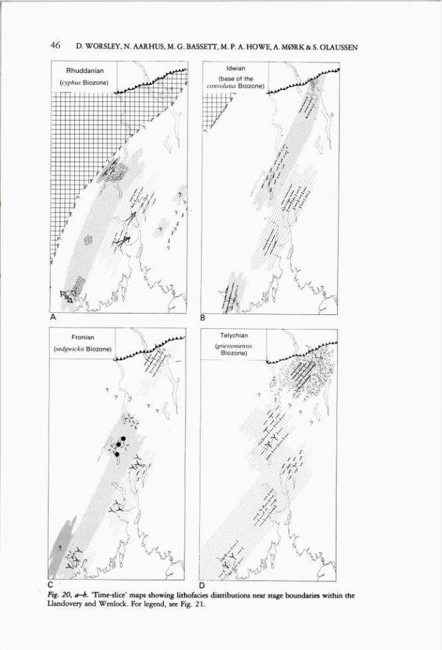
46 D. WORSLEY, N. AARHUS, M. G. BASSETT, M. P. A. HOWE, A. MØRK & S. OLAUSSEN
Fig. 20, a-b. 'Time-slice' maps showing lithofacies distributions near stage boundaries within theLlandovery and Wenlock. For legend, see Fig. 21.
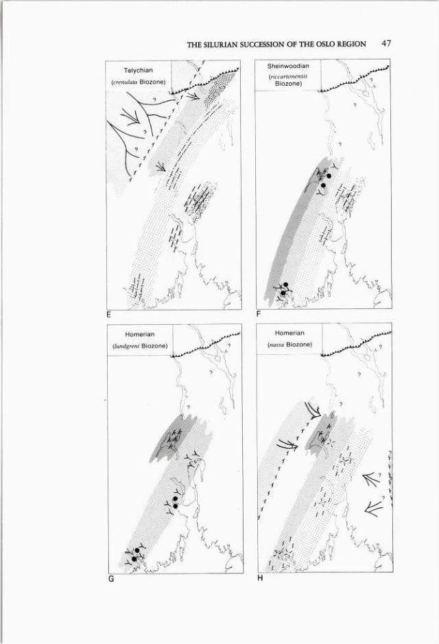
THE SILURIAN SUCCESSION OF THE OSLO REGION 47
G H
48 D. WORSLEY, N. AARHUS, M. G. BASSETT, M. P. A. HOWE, A. MØRK & S. OLAUSSEN
Fig. 21. Symbols used in Fig. 20.
districts passing eastwards into the distal environments of the shale-dominated
Solvik Formation. A better understanding of the biostratigraphy of late Ordovician
and early Silurian units in the Ringerike and Hadeland districts is necessary beforethis transgressive episode can be fully interpreted.
Rhuddanian and early IdwianThe development of the Sælabonn Formation in the western and southern districts
suggests that the transgression of these areas was followed by renewed coastalprogradation in the late Rhuddanian, producing the massive sandstones seen in
the middle of the formation. A renewed transgressive phase in the mid-Idwianis suggested by the fining-upwards sequence seen above these sandstones in
Ringerike and Skien; this transgression resulted in an submergence of the northerndistricts and the deposition of the Helgøya Quartzite Member on karstic surfacesof the Mjøsa Limestone.
The shale-dominated Solvik Formation in the Oslo and Asker districts shows
several noteworthy features. The lower parts of the Myren Member displayrelatively thick and frequent siltstone interbeds in their easternmost localities on
Malmøya. Equivalent sequences in Asker contain thinner and less common
siltstones with more frequent marly interbeds; both sediments and fauna suggestmore distal, but probably shallower, depositional environments in Asker. In both
Malmøya and Asker initial rapid transgression was followed by a gradual
THE SILURIAN SUCCESSION OF THE OSLO REGION 49
shallowing until the mid-Idwian when a reverse geographical pattern of depositionthen developed. Storm-generated siltstones deposited in low-energy mud environments are found in Asker but a more marly development on Malmøya contains
faunas and sedimentary structures indicating shallower and (at least intermittently)wave-reworked bottom conditions. The transition to these upper developmentsof the Solvik Formation is relatively sharp in both areas; the apparently
synchronous abrupt shallowing on Malmøya and deepening in Asker may havebeen caused by local block movements. The total facies mosaic seen throughoutthe Oslo Region supports this conclusion, as the transition apparently coincideswith the mid-Idwian transgression of the northern districts. The Asker developmentcan be understood within this mosaic, but the Malmøya sequence can only
be explained by a contemporaneous slight uplift of the eastern parts of thedepositional basin which produced more distal but shallower environments there.Exposures on Bjørkøya (Holmestrand) of the upper parts of the Solvik Formation
are similar to Asker, although sedimentary structures and faunas suggest somewhatmore proximal environments in Holmestrand.
Late Idivian and Fronian
The late Idwian development of the region shows the diachronous establishmentof carbonate-dominated environments reflecting the gradual submergence ofwestern and northern source areas. Ringerike, Hadeland and Skien retained their
marginal marine character, with thinly interbedded bioclastic limestones andshales rapidly grading up into thick and massive bioclastic limestones. These weredeposited on shallow shoals with mobile substrates repeatedly reworked by waveand tidal activity. Holmestrand, Asker and Oslo first became the site of
carbonate-dominated deposition around the Idwian/Fronian transition. Althoughthe massive bank developments observed further west are not seen in these more
distal areas, a general coarsening and shallow-upwards trend marks the earlyFronian development in these districts.
Small patch reefs found on the top of the bioclastic shoals in Ringerike indicatea mid-Fronian stabilization of those mobile bodies. Reef structures show several
developmental stages from stabilization to diversification phases, but their growthwas probably terminated by renewed rapid deepening and increasing influx ofclay.Similar trends are seen in both central and southern districts.
The nodular limestone development of the Rytteråker Formation seen in the
northemmost districts suggests more distal depositional environments with lowsedimentation rates. The positive nature of the northern districts in the lateOrdovician and early Silurian was now ended, presaging the marked subsidenceof those areas in the early Telychian.
Telychian
The gradational top of the carbonate-dominated Rytteråker Formation is bestdated in the northern districts, where overlying shales contain maximus to crispus
Biozone graptolite faunas. The age evidence is more circumstantial in other areas,but the development of the uppermost Rytteråker Formation and the basal parts
50 D. WORSLEY, N. AARHUS, M. G. BASSETT, M. P. A. HOWE, A. MØRK & S. OLAUSSEN
of both the Vik and Ek Formations in all districts indicate both deepeningdepositional environments and increasing clastic supply around the Fronian/Telychian transition. A new sedimentational pattern now emerged: markedsubsidence of the northern districts produced graptolitic shale environments whichshallowed southwards into more calcareous sequences with both faunas andsedimentary structures suggesting more moderate depths of deposition.
Bentonites are found in the Ek, Vik and Bruflat Formations; these havepreviously been suggested as a means of precise correlation between variousdistricts (Hagemann 1966). However, both our graptolite and other faunalevidence indicates that the bentonites rather represent a prolonged period ofintermittent volcanic activity ranging throughout the turricalutus to crenulataBiozones. The local red colour of the Vik Formationa shales has earlier been
interpreted as a result of deposition in continental environments (Hagemann1957), an interpretation which cannot be supported by our faunal and sedimentological data. Whitaker (1965, 1977) interpreted these marine deposits as theweathering products of lateritic earths resulting from volcanic activity in thedeveloping Caledonides. Bentonites do occur with red shales in the Ek Formation,but there are many other examples of marine red shales with no evidence ofcontemporaneous volcanism (and vise-versa). Whatever the primary source of thered shales, it is more interesting to consider the factors which have resulted in thepreservation of primary red colours. Franke & Paul (1980) note that marine red
shales always contain >2% Fe203 , and consider that the reduction of primarilydeposited ferric iron complexes was prevented by the generally oligotrophic natureof such shales' depositional environments. These conclusions fit well with the
occurrence of red shales in the Vik Formation: the red units contain sparse faunaswhile intercalated more fossiliferous and calcareous units are grey-green, possiblysuggesting diagenetic reduction of primary red muds. Both the Vik Formationared shales and similar Lower Palaeozoic units elsewhere have earlier been ascribed
to 'deep shelf, basin and ocean floor' depositional sites (Ziegler & McKerrow1975), and Silurian red shales in the Baltic area are found with Clorinda
community representatives in outer shelf environments (Bassett et al. in press.).Although red shales in the Oslo Region are associated with' somewhat shallowerbottom conditions than those suggested by Ziegler & McKerrow, knownoccurrences are found in areas marginal to the contemporaneous graptolitic basinfacies development of the northern districts.
The transition from the Ek or Vik Formations to overlying units is clearlydiachronous and Malmøya in the Oslo district is the only locality where thistransition approximates to the Llandovery/Wenlock boundary. In Ringerike andnorthern districts we date the transition to the Bruflat Formation as lower C 6 orbase crenulata Biozone. Contrary to previous assumptions we now know that theBruflat Formation is almost entirely of Llandovery age, with only the uppermostbeds possibly extending into the Wenlock. This suggests very high rates ofsedimentation for the Bruflat Formation in the late Telychian - especially in thenorthern districts - and prompts a closer examination of the formation'sdepositional environments. Bjørlykke (1974a:27) suggested a probable 'delta

THE SILURIAN SUCCESSION OF THE OSLO REGION 5 51
slope environment with deposition of distal turbidites' and later (Bjørlykkeop.cit.:3l) he envisaged the unit as representing 'a true deltaic facies' reflecting
' . . the initiation of a period of delta sedimentation, which gradually fdled upthe shallow sea with clastic sediments'. Although the lower parts of the formation
in the type area in Toten do show features which may be compatible withBjørlykke's model, its upper parts rather suggest that an initial rapid pro
gradation with high sedimentation rates was followed by stabilization and theestablishment of a wave-dominated clastic shelf environment characterised byextensive reworking of sediments and faunas in the uppermost Telychian. Initialprogradation rapidly fdled the foredeep established during the Fronian in thenorthern districts but this was followed by a change in depositional regime; neitherdelta top nor coastal environments are suggested by the uppermost developmentof the formation in the northern districts.
The Bruflat Formation in the Ringerike district shows a somewhat similar(although thinner) coarsening and shallowing-upwards sequence to that seen inthe type area. Siltstones and shales deposited below storm-range wave base gradeup into wave-reworked sandstones and siltstones with minor shales. The faunasalso suggest a shallowing-upwards trend, but the most proximal faunal associations seen are only typical of Benthic Assemblage 4 of Boucot 1975. Neithersediments nor faunas suggest any appreciably more distal development inRingerike than that of the northern districts. Thus the Bruflat sandstone reflects
a major easterly to southeasterly directed progradation of a coastline lying west ofboth Ringerike and the northern districts. This progradation infilled the northerlybasinal areas but depositional equilibrium was rapidly established, with thedevelopment of a wave-reworked platform in both areas. The subsequentdevelopment of the northern districts is conjectural in the absence of provenyounger Silurian deposits. The break in deposition marking the top of the Bruflat
Formation in Ringerike suggests a short period of emergence around theLlandovery/Wenlock boundary prior to the establishment of marginal marine
carbonate environments in the Lower Wenlock.
The development of the Vik Formation in Holmestrand and Skien is essentiallysimilar to that of Ringerike. The transition to the overlying Skinnerbukta
Formation (penecontemporaneous with the Vik/Bruflat formational boundary inRingerike) is also marked by a deepening trend in these other districts. However,
although faunas in Skien suggest a subsequent shallowing in the uppermostTelychian, coarse clastic supply was negligable, and the sequence there consists of
shales with minor calcareous siltstones and maris. A similar break in depositionto that seen in Ringerike occurs near to the Llandovery/Wenlock boundary inSkien. This part of the succession is both contact-metamorphosed and poorlyexposed in Holmestrand. In the Oslo and Asker districts deposition of nodularlimestones and maris assigned to the Vik Formation continued through most ofthe Telychian, with no signs of shallowing or break in deposition in the uppermost
Llandovery. In contrast, the late Llandovery there was marked by continueddeepening leading to deposition of the graptoliferous shales of the Skinnerbukta
Formation.

52 D. WORSLEY, N. AARHUS, M. G. BASSETT, M. P. A. HOWE, A. MØRK & S. OLAUSSEN
In summary, the uppermost Llandovery was marked by subsidence throughoutthe depositional basin, with subsidence being most marked in the northern districts
in the early to mid-Telychian. In these districts and in Ringerike we see asubsequent shallowing trend, with a major clastic progradation which terminatedin the late Telychian. The Holmestrand and Skien districts were not at any timenear any signiflcant clastic source areas, suggesting relatively greater uplift of thenorthwestern basin margins closer to the developing Caledonides. The more
gradual but continued deepening seen in the Oslo and Asker districts suggests thatthe total facies patterns reflect ongoing regional transgression coupled with localand differential tectonic movements along lineaments marking the westernmargins of the basin. These were responsible both for the northerly Bruflat
development and for the short period of uplift seen near the Llandovery/Wenlockboundary in Ringerike and Skien. However, the continuing transgression producedfirst a cut-off in clastic supply and subsequently the development of carbonateenvironments along the western margins of the basin in the early Wenlock.
Sheinwoodian and Homerlan
Previous interpretations of early Wenlock facies relationships through the regionhave been influenced by the assumption of a Wenlock age for the BruflatFormation. Størmer (1967) therefore envisaged a 'period of unrest' at that time.Subsequent authors (e.g. Bjørlykke 1974a, Ramberg & Spjeldnæs 1978) con
sidered the Bruflat Formation as representing the initiation of a continuingsouthwards deltaic progradation which culminated in the deposition of the Old
Red sediments of the Ringerike Group. As we have noted previously, the BruflatFormation represents a clastic influx which started and finished in the late
Llandovery; there is no evidence that this depositional episode is the same as thatwhich resulted in deposition of the Ringerike Group in the late Wenlock.
Although Wenlock sequences are not preserved in northern districts, exposures inthe rest of the region suggest the development ofNW-SE trending carbonate faciesbelts with little clastic supply.
Marginal marine environments with reefs developed in the Ringerike and Skiendistricts, after a short and as yet undefined period of emergence in the earlySheinwoodian. This reef zone passes through more distal marly sequences inHolmestrand into basinal shales in Asker and Oslo; faunas in the latter districts
suggest gradual deepening from restricted benthic environments in Asker to more
pelagic conditions on Malmøya. The reefs of Ringerike are overlain by sedimentswith a restricted lagoonal nature, suggesting a regressive episode in the mid-Sheinwoodian, which produced the basinwards migration of reefs and banks toa belt passing through Holmestrand. These structures protected an extensivehinterland where the restricted shallow subtidal to supratidal facies sequences now
preserved in Ringerike developed; the Asker and Oslo districts, meanwhile,continued to be the sites of more open marine depositional conditions. Small reefstructures developed in the Holmestrand and Skien districts in the late Sheinwoodian and early Homerian. In Holmestrand a common feature is the occurrence of
small patch reef cores in highly fossiliferous biostromes; these suggest the repeated
THE SILURIAN SUCCESSION OF THE OSLO REGION 53
wave destruction of incipient reefdevelopments and fully developed reef structures
only occur in 9d following a marked transgressive episode in the mid-Homerian.Contrary to previous suggestions the Wenlock is not marked by any ongoing
regressive trend; following regression in the mid-Sheinwoodian the area remainedstable until the mid-Homerian when the short-lived transgressive development
noted above produced the marine biostromes of the Favosites Limestone whichoccur interbedded with lagoonal deposits in Ringerike. The available evidence
suggests that this sharp transgressive pulse was followed in the late Homerian bylarge-scale coastal progradation and the deposition of terrestrial red beds inRingerike. This transition was probably diachronous, with red bed depositioncommencing somewhat later in the Asker district. We have as yet no evidence ofthe age of the transition to red bed deposition further south in the region.
The Wenlock development of the Oslo Region was therefore not marked bycontinuous regression and coastal progradation. Depositional environments werecharacterised by low clastic supply and the establishment of stable carbonate
platform environments subject to minor transgressive and regressive pulses. Thispattern terminated in the late Homerian as a result of renewed large-scaleregression and progradation. McKerrow (1979) has suggested a eustatic fall in sealevel in several areas east of the lapetus Ocean in the late Wenlock. A subsequent
transgressive episode in the early Ludlow is not seen in the Oslo region as localuplift in this segment of the Caledonides transformed the entire depositional basininto a site of terrestrial sedimentation.
Acknowledgements. - Professor Gunnar Henningsmoen and the late Professor Leif Størmer introducedus to the stratigraphy of the Oslo Region and inspired us to begin this work. Gunnar Henningsmoenhas also given invaluable information and comments at all stages of the study. Many other colleagueshave also supplied us with information and discussed various aspects of our proposals, and weespecially thank R.J. Aldridge, B.G. Baarli, K. Bjørlykke, J.F. Bockelie, D.L. Bruton, N.-M.Hanken, A.W. Owen, N. Spjeldnæs and E. Thomsen. Dr. L.R.M. Cocks critically read thepenultimate draft of the paper, and we are very grateful for his technical and scientific comments.Last but not least, our heartfelt thanks to Liza Kravik and Mette A. Sagmo for inexhaustible patiencewith the preparation of innumerable drafts of figures and text. We gratefully acknowledge projectsupport from NAVF (the Norwegian Research Council for Science and the Humanities) and financialsupport to Howe from a NATO Overseas Research Studentship. Bassett thanks the Nation Musumof Wales for granting support and generous periods of leave to participate in the project.
REFERENCESAarhus, N. 1978: Bergarter og tabulate koraller tverst i Landovery pd Ringerike. Unpubl. Cand.real.
thesis, University of Oslo, 146 pp.Aldridge, R.J. 1974: An amorphognathoides zone conodont fauna from the Silurian of the Ringerike
area, south Norway. Nor. geol. Tidsskr. 54, 295—303.Aldridge, R.J. 1975: The stratigraphical distribution of conodonts in the British Silurian. Jl. Geol.
Soc. 131, 607-618.Aldridge, R.J., Doming, K.J., HUI, P.J., Richardson, J.B. & Siveter, D.J. 1979: Microfossil
distribution in the Silurian of Britain and Ireknd, pp. 433-438. In A.L. Harris, C.H. Holland& B.E. Leake (eds.): "The Caledonides of the British Isles reviewed>. Geol. Soc. Lond. Spee. Publ.8. Scottish Academic Press, Edinburgh.
Baarli, B.G. 1981: En analyse av bentiske fossil-samfunn og faciesvariasjoner i Solvikformasjonen(undersilur) i Asker. Unpubl. Cand.real. thesis, University of Oslo, 227 pp.
54 D. WORSLEY, N. AARHUS, M. G. BASSETT, M. P. A. HOWE, A. MØRK & S. OLAUSSEN
Bassett, M.G. 1979: Brachiopods, pp. 185-206 in V. Jaanusson, S. Laufeld & R. Skoglund (eds.):Lower Wenlock faunal and floral dynamics - Vattenfallet Seaion, Gotland. Sver. geol. unders.Ser. C. nr. 762.
Bassett, M.G., Cherns, L., Larsson, K. & Martinsson, A.: (in press.): Key points for correlation inthe Silurian of Gotland. Palaeontology.
Bassett, M.G. & Cocks, L.R.M. 1974: A review of Silurian brachiopods from Gotland. Fossils andStrata 3, 56 pp.
Bassett, M.G., Cocks, L.R.M., Holland, C.H., Rickards, R.B. & Warren, P.T. 1975: The typeWenlock Series. Report Inst. Geol. Sei. Lond. 75/13, 19 pp.
Bassett, M.G. & Rickards, R.B. 1971: Notes on Silurian stratigraphy and correlation in the Oslodistrict. Nor. geol. Tidsskr. 51, 247-260.
Bjerreskov, M. 1975: Llandoverian and Wenlockian graptolites from Bornholm. Fossils and Strata8, 93 pp.
Bjørlykke, K. 1974a: Depositional history and geochemical composition of Lower Palaeozoicepicontinental sediments from the Oslo region. Nor. geol. unders. 305, 81 pp.
Bjørlykke, K. 1974b: Geochemical and mineralogical influence of Ordovician islands arcs onepicontinental clastic sedimentation. A study of Lower Palaeozoic sedimentation in the Osloregion, Norway. Sedimentology 21, 251-272.
Bockelie, F.J. 1973: The presence of Prunocystites (Cystoidea) in Stage 9e of Ringerike, Norway.Nor. geol. Tidsskr. 53, 317-322.
Boucot, A.J. 1975: Evolution and extinction rate Controls. Developments in Palaeontology andStratigraphy 1. 422 pp., Elsevier Publishing Co., Amsterdam.
Brenchley, P.J. & Newall, G. 1975: The stratigraphy of the Upper Ordovician Stage 5 in theOslo-Asker district, Norway. Nor. geol. Tidsskr. 55, 243-277,
Brenchley, P.J. & Newall, G. 1977: The significance of contorted bedding in upper Ordoviciansediments of the Oslo Region, Norway./ sedim. Petrol. 47, 819-833.
Brenchley, P.J. & Newall, G. 1980: A facies analysis of Upper Ordovician regressive sequences inthe Oslo Region - a record ofglacio—eustatic changes. Palaeogeogr. Palaeoclimatol. Palaeoecol. 31,1-38.
Brenchley, P.J., Newall, G. & Stanistreet, I.G. 1979: A storm surge orgin for sandstone beds in anepicontinental platform sequence, Ordovician, Norway. Sediment. Geol. 22, 185-217.
Brøgger, W.C. 1931: Die Eruptivgesteine des Oslogebietes. V. Der grosse Hurumvulkan. Skr. NorskeVitensk.-Akad. Oslo, I. Mat.-Naturvit. kl. 1930, No. 6, 146 pp.
Calef, CE. & Hancock, N.J. 1974: Wenlock and Ludlow marine communities in Wales and theWelsh Borderland. Palaeontology 17, 779-810.
Cocks, L.R.M. 1971: Facies relationships in the European Lower Silurian. Mém. Bur. Recb. géol.miniér 73, Colloque Ordovicien-Silurien, Brest, Septembre 1971, 223-227.
Cocks, L.R.M., Holland, C.H., Rickards, R.B. & Strachan, I. 1971: A correlation of Silurian rocksof the British hles.Jl. geol. Soc. Lond. 127, 103-136.
Cocks, L.R.M., Toghill, P. & Ziegler, A.M. 1970: Stage names within the Llandovery Series. Geol.Mag. 107, 79-87.
Dons, J.A. & Gydry, E. 1967: Permian sediments, lavas and faults in the Kolsås area W of Oslo.Nor. geol. Tidsskr. 47,57-77.
Franke, W. & Paul, J. 1980: Pelagic redbeds in the Devonian of Germany - deposition anddiagenesis. Sediment. Geol. 25, 231-256.
Gross, W. 1967: Über Thelodonter - Schuppen. Palaeontographica 127a, 1-167.Gross, W. 1968: Die Agnathan - Fauna der silurischen Halla Schichten Gotlands. Geol. For.
Stockholm Forhandl. 90, 369-^OO.Hagemann, F. 1957: On the petrography of the Silurian shales from Hadeland, Norway. Nor. geol.
Tidsskr. 37, 229-246.Hagemann, F. 1966: Silurian bentonites in the Oslo region. Nor. geol unders. 242, 44-61.Hanken, N.-M. 1974: En undersekelse av 5b sedimentene pd Ullerntangen, Ringerike. Unpubl.
Cand.real. thesis, University of Oslo, 131 pp.Hanken, N.-M. 1979: Sandstone pseudomorphs of aragonite fossils in an Ordovician vadose zone.
Sedimentology 26, 135-142.Hanken, N.-M., Olaussen, S. & Worsley, D. 1979: Silurian bioherms in the Oslo Region (Norway).
Reefs Newsletter 5, 33-35.Hanken, N.-M. & Størmer, L. 1975: The trail of a large Silurian eurypterid. Fossils & Strata 4,
255-270.
THE SILURIAN SUCCESSION OF THE OSLO REGION 5 55
Heintz, A. 1939: Cephalaspida from the Downtonian of Norway. Skr. Norske Vitensk.-Akad. i Oslo,I. Mat.-Naturv. KJ. (1939). no. 5, 119 pp.
Heintz, A. 1969: New Agnaths from the Ringerike Sandstone. Skr. Norske Vitensk.-Akad. i OsloI. Mat.-Naturv. kl. Ny serie no. 26, 28 pp.
Heintz, A. 1974: Additional remarks about Hemicyclaspis from Jeløya, southern Norway. Nor. geol.Tidsskr. 54, 375-384.
Henningsmoen, G. 1954: Silurian ostracodes from the Oslo region, Norway 1. Beyrichacea. Witha revision of the Beyrichiidae. Nor. geol. Tidsskr. 34, 15-71,
Henningsmoen, G. 1955: Om navn på stratigrafiske enheter. Nor. geol unders. 191, 5-17.Henningsmoen, G. 1960: Cambro-Silurian deposits of the Oslo region.pp. 130-150. In O.
Holtedahl (ed.): 'Geology of Norway'. Nor. geol. unders. 208.Henningsmoen, G. 1978: Sedimentary rocks associated with the Oslo Region Lavas. pp. 17-24 in
J.A. Dons & B.T. Larsen (eds.): "The Oslo paleorift, a review and guide to excursions". Nor. geol.unders. 337.
Høeg, O. A. & Kiær, J. 1926: A new plant-bearing horizon in the marine Ludlow of Ringerike.Skr. Vidensk. Selsk. Kristiania Mat.-Naturv. KJ. I 1926 (1), 12 pp.
Høy, T. & Bjørlykke, A. 1980: Hamar, berggrunnskart 1916 IU-M, 1:50.000. Nor. geol unders.Holtedahl, O. 1953: Norges geologi. Nor. geol. unders. 164, 118 pp.Ingram, R.L. 1954: Terminology for the thickness of stratification and parting units in sedimentary
rocks. Geol. Soc. Amer. Bull. 65, 937-938.Johnson, M.E. 1979: Evolutionary brachiopod lineages from the Llandovery Series of eastern lowa.
Palaeontology 22, 549-567.Jørgensen, P. 1964: Mineralogical composition of two Silurian bentonite beds from Sundvollen,
southern Norway. Nor. geol. Tidsskr. 44, 227—234.Kiær, J. 1897: Faunistische Uebersicht der Etage 5 des norwegischen Silursystems. Skr. Videnskab.
Selsk. Kristiania I Mat.-Naturv. kl. 3, 76 pp.Kiær, J. 1908: Etage 5 i Asker (English Summary). Nor. geol. unders. 34, 111 pp.
Kiær, J. 1908: Das Obersilur im Kristianiagebiete. Eine stratigraphisch-faunistische Untersuchung.Skr. Vidensk. Selsk. Kristiania I Mat.-Naturv. KJ. 1906 11, 596 pp.
Kiær, J. 1911: A new Downtonian fauna in the Sandstone Series of the Kristiania area. A preliminaryreport. Skr. Vidensk. Selsk. Skr. Kristiania, I Mat.-Naturv. Kl. (1911), 22 pp.
Kiær, J. 1920: Oversikt over kalkalgefloraene i Norges ordovicium og silur. Nor. geol. Tidsskr. 6,113-140.
Kiær. J. 1922: Siluren i Brumunddalen og Veldre. Nor. geol. Tidsskr. 6, 211-216.Kiær, J. 1924: The Downtonian fauna of Norway I. Anaspida, with a geological introduction. Skr.
Vidensk. Selsk. Kristiania Mat.-Naturv. Kl. 6, 139 pp.Kiær, J. 1931: Hemicyclaspis murchisoni faunaen i den downtoniske sandsten på Jeløen i Oslofjorden.
Nor. geol. Tidsskr. 12, 419-433-Kjerulf, T. 1857: Ueber die Geologie des Sudlichen Norwegens. Nyt. Mag. Naturvid. 9, 193-333-
Jackson, D.E. & Etherington, J.R. 1969: New Silurian cyrtograptid graptolites from northwesternCanada and northern Greenland. Jour. Paleont. 43, 1114—1121.
Lauritzen, 0. & Worsley, D. 1974: Algae as depth indicators in the Silurian of the Oslo region.Lethaia 7, 157-161.
Lervik, A. 1970: En stratigraftsk understkelse av etasje 5 i Barum. Unpublished Cand.real. thesis,University of Oslo.
Major, H. 1946: Noen profiler fra eldste Silur i Oslofeltets nordlige deler. Nor. geol. Tidsskr. 26,59-142.
Martinsson, A. 1969: Correlation of Silurian ostracode faunas in Norway. Ludlow Res. Group Bull.16, 27-28.
Martinsson, A., Bassett, M.G. & Holland, C.H. 1981: Ratification of Standard Chronostratigraphical Divisions and Stratotypes for the Silurian System. Episodes 1981, 2, 36.
McKerrow, W.S. 1979: Ordovician and Silurian changes in sea level. Jl. Geol. Soc. Lond. 136,137-145.
Mørk, A. 1977: En stratigraftsk, sedimentologisk og paleotkologisk understkelse av undersiluriskesedimenter (6c-7a,b) i Oslofeltet, med hovedvekt på Bjerktya ved Holmestrand. Unpublished
Cand.real. thesis, University of Oslo, 241 pp.Mørk, A. 1981: A reappraisal of the Lower Silurian brachiopods Borealis and Pentamerus.
Palaeontology 24, 537-553-Mørk, A. & Worsley, D. 1980: The environmental significance of algae in the middle Llandovery
succession of the central Oslo Region. Lethaia 13, 339-346.

56 D. WORSLEY, N. AARHUS, M. G. BASSETT, M. P. A. HOWE, A. MØRK & S. OLAUSSEN
Nicholson, R. 1979: Caledonian correlations: Britain and Scandinavia. 3-18 in A.L. Harris, C.H.Holland & B.E. Leake (eds.): 'The Caledonides of the British Isles - reviewed'. Geol. Soc. Spee.Publ. 8, Scottish Academic Press, Edinburgh.
Nystuen, J.P. 1981: The Late Precambrian 'sparagmites' of Southern Norway: a major Caledonianallochthon - The Osen-Røa nappe complex. Am. Jour. Sei. 281, 69-94.
Olaussen, S. 1978: Stratigraft, avsetningsmiljt og diagenese i Oslofeltets yngste marine kambrosiluravsetninger (etasjene Bc, 8d og 9) i Bærum og Ringerike. Unpublished Cand.real. thesis, Universityof Oslo, 275 pp.
Olaussen, S. 1981a: Marine incursion in Upper Palaeozoic sedimentary rocks of the Oslo Region,southern Norway. Geol. Mag. 118, 281-288.
Olaussen, S. 1981b: Formation of celestite in the Wenlock, Oslo Region, Norway - evidence forevaporitic depositional environments. Jour. Sed. Petrol. 51, 37-46.
Owen, A.W. 1978: The Ordovician and Silurian stratigraphy of central Hadeland, South Norway.Nor. geol. unders. 338, 1-23-
Ramberg, 1.8. 1976: Gravity interpretation of the Oslo graben and associated igneous rocks. Nor.geol. unders. 325, 194 pp.
Ramberg, 1.8. & Spjeldnæs, N. 1978: The tectonic history of the Oslo Region, pp. 167-194. InLB. Ramberg & E.R. Neumann (eds.): Tectonics and Geophysics of Continental Rifts. ReidelPublishing Co., Dordrecht.
Rickards, R.B. 1976: The sequence of Silurian graptolite zones in the British isles. Geol. Jour. 11153-188.
Rønning, K.J. 1979: Stratigraphy and sedimentology of the Upper Ordovician Stage 5b sediments of theSkien-Langesund district, Oslo Region, Norway. Unpublished Cand.real. thesis, Univ of Bergen229 pp.
Rosendahl, H. 1929: Brumunddalens porfyr-sandsteinlagrekke. Nor. geol. Tidsskr. 10, 367-438.Rubel, M. 1977: Evolution of the genus Stricklandia (Pentamerida, Brach.) in the Llandovery of
Estonia, pp. 193-212. ln D. Kaljo (ed.): Facies andfauna ofthe Baltic Silurian. Academy of Sei.,Estonian S.S.R., Institute Geol., Tallinn, 286 pp. (in Russian).
Seilacher, A. & Meischner, D. 1964: Fazies-Analyse im Palåozoikum des Oslo-Gebietes. Geol. Rsch.54, 596-619.
Skjeseth, S. 1963: Contributions to the geology of the Mjøsa District and the classical sparagmitearea in Southern Norway. Nor. geol. unders. 220, 126 pp.
Spjeldnæs, N. 1957: The Silurian/Ordovician border in the Oslo district. Nor. geol. Tidsskr. 37355-371.
Spjeldnæs, N. 1966: Silurian tidal sediments from the base of the Ringerike Formation, Oslo region,Norway. Nor. geol. Tidsskr. 46, 497-509.
Størmer, L. 1934a: Merostomata from the Downtonian sandstone of Ringerike, Norway. Skr. NorskeVidensk.-Akad. Oslo I Mat.-Naturv. KJ. (1933), W, 125 pp.
Størmer, L. 1934b: Eurypterid remains from the Ludlow zone 9d of Ringerike. Nor. geol. Tidsskr14, 119-126.
Størmer, L. 1935: Dictyocaris Saker, a large crustacean from the Upper Silurian and Downtonian.Nor. geol. Tidsskr. 15, 265-298.
Størmer, L. 1938: Eurypterusfischeri in Ludlow beds (9d) at Ringerike. Nor. geol. Tidsskr. 18, 69-70.Størmer, L. 1942: Tørkesprekker i siluren på Ringerike. Nor. geol. Tidsskr. 21, 290.Størmer, L. 1953: The Middle Ordovician of the Oslo Region, Norway. 1. Introduction to
stratigraphy. Nor. geol. Tidsskr. 31, 37-141.Størmer, L. 1967: Some aspects of the Caledonian geosyncline and foreland west of the Baltic shield.
Q.JI. Geol. Soc. Lond. 123, 183-214.
Strand, T. & Størmer, L. 1955: Lexique stratigraphique international vol 1, Fase. 2a Norvége - Norge- Norway. 101 pp. Paris.
Thomsen, E. 1981: En palaeontologisk, sedimentologisk og stratigraftsk analyse af Scelabonn Formationen (Silur-Norge). Unpubl. thesis, Univ. of Copenhagen, 319 pp.
Turner, P. 1974a: Lithostratigraphy and facies analysis of the Ringerike Group of the Oslo region.Nor. geol. unders. 314, 101-131.
Turner, P. 1974b: Marine calcarenites from the Ringerike Group (Stage 10) of southern Norway.Nor. geol. Tidsskr. 54, 1-12.
Turner, P. 1974c: Origin of red beds in the Ringerike Group (Silurian) of Norway. Sedim. Geol.12, 215-235.
Turner, P. & Turner, S. 1974: Thelodonts from the upper Silurian of Ringerike, Norway. Nor. geol.Tidsskr. 54, 183-192.

THE SILURIAN SUCCESSION OF THE OSLO REGION 5 57
Turner, P. & Whitaker, J.H.McD. 1976: Petrology and provenance of late Silurian fluviatilesandstones from the Ringerike Group of Norway. Sediment. Geol. 16, 45—68.
Whitaker, J.H.McD. 1964: Mud-crack diapirism in the Ringerike sandstone of southern Norway.Nor. geol. Tidsskr. 44, 19-30.
Whitaker, J.H.McD. 1965: Primary sedimentary structures from the Silurian and Lower Devonianof the Oslo region, Norway. Nature 207, 709-711.
Whitaker, J.H.McD. 1966: The Silurian and Lower Devonian geology of Ringerike, Norway.Unpublished Ph.D. thesis. Leicester University, 2 vols.
Whitaker, J.H.McD: 1980: A new trace fossil from the Ringerike Group, southern Norway. Proe.Geol. Assoc. 91, 85-89.
Williams, A. 1951: Llandovery brachiopods from Wales with special reference to the Llandoverydistrict. Q. Jl. geol. Soc. Lond. 101, 85-136.
Worsley, D. 1971: Faunal anticipation in the lower Llandovery of the Oslo Region, Norway. Nor.geol. Tidsskr. 51, 161-169.
Worsley, D. & Broadhurst, F.M. 1975: An environmental study of Silurian atrypid communitiesfrom southern Norway. Letbaia 8, 271—286.
Ziegler, A.M. 1966: The Silurian brachiopod Eocoelia bemisphaerica (J. de C. Sowerby) and relatedspecies. Palaeontology 9, 523-543.
Ziegler, A.M., Cocks, L.R.M. & Bambach, R.K. 1968: The composition and structure of LowerSilurian marine communities. Letbaia 1, 1—27.
Ziegler, A.M., Cocks, L.R.M. & McKerrow, W.S. 1968: The Llandovery transgression of the WelshBorderland. Palaeontology 11, 736—782.
Ziegler, A.M. & McKerrow, W.S. 1975: Silurian marine red beds. Am. J. Sei. 275, 31-56.

RECENT MAPS PUBLISHED BY NGU(A list of earlier maps appears on the inside back cover of all Bulletins and Skrifter fromand including Bulletin 20, NGU nr. 300)
Quaternary geologyMosjøen ->- 2016 1 V Elverum
1: 50 000 20281 Beiardalen Bedrock geology 1817 II Lillehammer
1916 1 V Hamar1214 1 V Husnes19161 Løten1720 111 Røros
Sand and gravelresources
1: 20 000 Brandbu CKL 057058-20 Quaternary geology
Skei BQR 115116-20Stiklestad CUV 135136-20Tromsdalen CUV 133134-20Vardefjell DOP 183184-20
1: 10 000 Helgja BW 030-10 Quaternary geology
MAPS IN BLACK AND WHITE (on sale direct from NGU either as paper-copies(N.kr. 12,-) or as transparent-copies (N.kr. 100,-).
1:250 000 Bodø Bedrock geology (preliminary)
1: 50 000 2135 1 Adamsfjord Bedrock geology (preliminary)1611 IV Arendal ->- ->-
1318 111 Breim ->- ->-
1817 111 Follebu ->- ->-1927 I Mo i Rana ->- ->-
1316 11 Ulvik ->- ->-1316 111 Voss ->- ->-
1521 II Hølonda Natural environmental potential (GMNEP)15211 Orkanger ->-—>—1612 111 Støren ->-1612 IV Trondheim ->-
A list of other maps (hydrogeology, geochemistry, geophysics) issued by the GeologicalSurvey is available upon request.
MAPS PRINTED IN COLOUR (On sale from Universitetsforlaget, N.kr. 30,-).1:250 000 Mandal Bedrock geology 1: 50 000 1117 IV Askvoll
—>——>——>——>——>——>——>——>—
Nordkapp ->- 1917 I Evenstad1815 1 Gran
1413 IV Botsvatn1720 11 Brekken17161 Bruflat1719 11 Elgå
1713 IV Nordagutu1935 I Repparfjorden1417 IV Solvorn1917 111 Åsmarka
—>——>——>——>——>——>——>——>——>——>——>—
18161 Gjøvik
1918 111 Stor-Elvdal1918 11 Storsjøen1414 11 Sæsvatn
Lunner CMN 053054-20Lygna CMN 057058-20Mosjøen DMN 181182-20Olderskog DOP 181182-20
—>——>——>—
—>——>——>——>—
Lillehammer ->- —>—Røros ->- ->-
Stavanger ->- ->-Sveg ->- ->-Tromsø ->- —>—
Vega ->- ->-
1517 111 Borgrund ->- ->-
1218 II Fimlandsgrend ->- ->-
1418 11 Mørkrisdalen ->- ->-
18241 Namskogen ->- ->-18181 Sollia ->- ->-2029 111 Strømøen ->- ->-1518 111 Sygnefjell ->- ->-1533 111 Takvatnet ->- ->-2135 II Ul'lugai'sa ->- ->-
Brattli HUV 269370-20Drammen CHJ 041042-20Gran CMN 055056-20Grymyr CKL 055056-20Jømna CWX 065066-20Kulstad DMN 183184-20Langvasseid HST 269270-20Levanger CST 133134-20