Embed Size (px)
Citation preview


Dufferin Wind – Review Comments of – SIR, EOS, EIS
Page 1 of 4
Site Investigation Report:
Whitney given your comments (Jim Beal’s interest in looking closely at the ELC and wetland mapping) I focused my efforts on Figures 4 & 5 and Tables 5 & 6 (ELC and wetland mapping respectively) of the Site Investigation Report (SIR). Review of wetland mapping particularly based on wetland shapefiles submitted in support of the report
There is an inconsistent approach to mapping ELC/wetland features relative to project location and 120m setback. In places features/landscape is mapped well beyond the Project Location (PL) and setback, where in other situations mapping is stopped just beyond the project limits or not mapped at all. Some comments below might be attributed to the inconsistent approach (i.e. suggesting wetland or ELC feature was not mapped fully – e.g. Comment 12 below).
For the most part it appears that the wetland units were defined based on mapping of the ELC marsh, swamp and open water community types, and not clearly based on the OWES criteria. Two vegetation communities in Table 5 in particular raise questions of accuracy of the wetland mapping based on their vegetation species composition … � MEGM4-1 Open Graminoid Meadow Type (Community # 40 in Figure 4) – the noted species
in Table 5 are common wetland species and should support a wetland designation to any such mapped community. There are a couple of examples these communities were not incorporated into the wetland mapping.
� MEMM4 Fresh-Moist Mixed Meadow Ecosite (Community # 42 in Figure 4) – some of the vegetation species noted in Table 5 are common wetland species, and although noted in situations surrounded by wetland and agricultural environments none of these designated communities are incorporated into the wetland mapping.
Have found that in some areas along the rail ROW (230kV route) where the wetland mapping is not inaccurate that signing off that pole placement will not impact the wetland will be difficult due to the limited resolution of aerial photography available. Essentially to confirm pole placement with respect to the wetland, a site visit is recommended to confirm no conflict with the Regulation as that relates to project location and provincially significant wetlands.
Attached for reference are 4 jpeg maps with red shapes and corresponding yellow number labels. These sites are addressed sequentially below and speak to issues identified in the mapping of wetland/ELC features.
Some of the comments might be attributed to what photos they worked from relative to coverage we have available. Further my questions on accuracy of wetland mapping are based solely upon photo interpretation; no ground truthing was done by me.
Comments associated with the area of the turbine field and proposed 230kV route: 1 – Wetland Unit (WU) 2, Fig 5a – wetland boundary is offset from the feature as viewed in photos.
2 – Fig 5a – proposed substation within this forest block. This is the only woodlot identified as specialized raptor nesting habitat that would be influenced by the project location and 120m setback (Fig 11).
3 – WU7 in Fig5a – identified as wetland but not typed in ELC mapping (Fig4a); accuracy of wetland boundary, looks to be upland forest included in wetland? Looks mapped largely based on “Wetland Units” layer that would be in LIO as unevaluated wetland. The 120 setback imposes on the south side.
4 – WU10 in Fig 5a – accuracy of mapping in question, area of open water in 2008 photos, include within the wetland? Could be potential amphibian habitat? Area is dry in 2010 photos, but could still be wetland.

Dufferin Wind – Review Comments of – SIR, EOS, EIS
Page 2 of 4
5 – WU12 Fig 5a – accuracy of wetland mapping; Fig 4a & 5a show infrastructure going through west side of wetland feature.
6 – WU15 Fig5a and Fig4a – accuracy of wetland mapping, wetland and ELC mapping don’t match. Large area not ELC typed, likely as outside of project location.
7 – Question the ELC typing of this wooded area. With drainage and water apparent in aerial photos, along with similar wetland character in WU16 (Fig5a) to the SW, question accuracy of mapping.
8 – WU17 Fig5a – wetland mapping matches ELC mapping in Fig4a, question ELC typing and wetland mapping in area of T34, 35 & 36.
9 – WU21 Fig 5a – accuracy of wetland mapping – conifer plantation and rural property mapped within wetland at east end of unit.
10 – East end of WU22, Fig 5a – Wetland and ELC mapping do not match, ELC wetland vegetation communities not recognized in Fig 5a and the wetland shapefiles.
11 – Forest block adjacent to T31, 32 & 42 (Fig 4a and 5a) is not all sugar maple, appears similar in character to wetland area to the north (WU11). Project location and setback impose on this woodlot.
12 – North end of WU28, Fig 5a – accuracy of wetland mapping, area of open water and meadow marsh omitted from wetland mapping.
13 – WU25, Fig 5a – question accuracy of wetland mapping, missed wetland ELC community types.
14 – WU26, Fig5a – question if ELC10 (Fig4a) is a naturalized conifer plantation type?
General Note: Fig 4a – only the north side of the 230kV route extending SW from the turbine field is typed by ELC.
15 – WU36-44 Fig 4b & 5b – Wetland boundary should be drawn tight to rail ROW. This is a consistent comment along the rail ROW.
16 – WU47&48 Fig 4b & 5b – accuracy of wetland/ELC mapping; e.g. questioning exclusion of ELC42 from wetland mapping.
17 – WU51&52 Fig4b&5b - accuracy of wetland/ELC mapping; e.g. questioning exclusion of ELC42 from wetland mapping.
(18 & 19 to be addressed below with comments for 69kV route)
20 – WU58 and ELC38 Fig 4c & 5c – accuracy of wetland mapping, from photo interpretation it looks possible that WU58 could be extend south to include area of ELC38.
21 – WU62&63, Fig4c & 5c – accuracy of wetland mapping – north half of ELC45 just south of WU62 could be meadow marsh, suggest from 2010 photos it is not open pasture.
22 – WU64-69, Fig 4c & 5c – accuracy of wetland mapping – wetland map entirely based on ELC mapping, suggest ELC42 on west side of rail ROW should be included in wetland (see community description in Table 5); snug wetland to rail ROW. (The new wetland area could

Dufferin Wind – Review Comments of – SIR, EOS, EIS
Page 3 of 4
actually be considered PSW as they are extensions of or proximal to existing evaluated provincially significant wetland units).
23 – WU64, Fig 4c & 5c – accuracy of wetland mapping – questioning exclusion of ELC42 from wetland mapping.
24 – WU71 & 72, Fig 4d (“Legend” needs correction from 4c to 4d) &5c – suggest ELC40 (MEGM4-1) just north of WU72 should be in wetland as species noted in Table 5 for this community are common wetland species; Similar to Note #15 snug wetland to rail ROW.
25 – WU73 Fig4d & 5c – accuracy of wetland mapping, questioning exclusion of ELC42 from wetland mapping.
26 – WU74 Fig 4d & 5d – accuracy of wetland mapping, similar to comment 15 wetland looks to be snug to rail ROW.
27 – WU76-81 Fig 4d & 5d – accuracy of wetland mapping, snug wetland to rail ROW; questioning exclusion of ELC42 from wetland mapping.
Comments associated with the area of the turbine field and proposed 69kV route: 18 – Fig 4c – accuracy of mapping - ELC25 along 30th Sideroad looks to be predominant conifer forest vs white birch dominant. Companion vegetation species are common wetland species (tamarack, green ash, balsam poplar, red-osier dogwood and pussy willow), community should be mapped wetland?
19 – WU83 & 84, Fig 5c & 4c – accuracy of wetland mapping of Significant Wetland shapefile, ELC67 (wetland veg community) extends east of road.
28 – WU89, Fig4c & 5c – accuracy of wetland mapping – photo interpretation suggests wetland in the forested area, area feeds creek to south?
29 - WU89, Fig4c & 5c – accuracy of wetland mapping; and wetland north along the road should be snug with road ROW (1st Line).
30 – WU85 & 86, Fig 4c & 5c – Accuracy of wetland mapping, photo interpretation suggest more wetland as part of WU85 & 86 (within ELC20 in the NE corner of road intersection).
Woodlands – Table 7 - it is not clear how the Linkage Functions were defined. An explanation of criteria used would be helpful. For example, question why Woodland S is determined to not provide a linkage function (has interior forest habitat, has watercourse flow through it, and is proximal to wetland features).
Specialized raptor nesting habitat – Table 8, pg 127 – Woodland BN is identified as a candidate SRNH, but rationale seems to provide two contradictory explanations. Is that woodland a candidate habitat?
Evaluation of Significance Report:
From Comments above re SIR – in 2nd page of Table 1 of EOS report two comments about missed wetland mapping (my interpretation) in two woodlots. � There is a woodlot with unidentified wetland between WU11 & 12 which would require SI,
EOS & EIS as part of PL is proposed within the wetland area. See my SIR Comment #11. � There is a woodlot with unidentified wetland just NE of WU16 which would require SI, EOS &
EIS as it is within 120m setback around its perimeter. See my SIR Comment #7.

Dufferin Wind – Review Comments of – SIR, EOS, EIS
Page 4 of 4
Page 70 – Amphibian Breeding Survey – This section notes the Marsh Monitoring Protocol was used to survey for breeding amphibians. It is curious to note that amphibian sample locations are the same survey locations as the crepuscular bird surveys (Figures 13a-d and 6a-d respectively). It appears as though many of the survey locations were not in keeping with the MMP for amphibians where a lot of survey effort appears to have been extended to non-marsh habitats.
Further, and similarly noted for the various breeding bird surveys, many of the survey locations apart from the area of the turbine field (i.e. those surveys intended to study the transmission line routes) are well removed from the candidate habitat features targeted in the Evaluation of Significance report. As the preferred option for the transmission line is an abandoned rail line access to conduct appropriate surveys in the target candidate habitats should have been unencumbered. Time spent surveying for birds and amphibians upwards of two concession roads from the target habitat features could easily have been directed to those features; and does not inform the study on habitat use in the project location/120m setback.
The assumption of significance is being applied to most of the candidate wildlife habitats associated with the transmission line routes, with the intent of addressing level of significance prior to the construction phase (see Section 6.5, p 45, last sentence).
Table 4 – Unevaluated Wetland Unit Assessment � The dates of visits to the individual wetland units would be helpful. � It is not clear how Interspersion was evaluated, Score for Catchment Area? Were wetland
units complexed in order to determine an interspersion score? E.g. Wetland 72 recorded 174 intersections for a 2.2 ha single veg community wetland unit?
� Wetlands 7-11, Wetland Type, Vegetation Community and/or Open Water Type do not correspond with their ELC and/or wetland community descriptions.
� Wetland Unit 28 – re the open water type – see the comment #12 above for SIR review; open water associated with that community that was not incorporated into the Wetland Unit mapping.
� Wetland 72 – Open Water Type – from photo interpretation wetland unit has an open water pond, suggest an open water type 1 for community.
Table 5 – Woodland Evaluation � Woodland S – Linkages – watercourse runs through it - considered fish habitat; linked
hydrologically and proximal to other wetland/woodlot features that would lend to the ecological linkage function;
� Woodland S – Woodland Diversity Representation – suggest revisiting the ELC composition of this woodlot
� Woodland BL - Woodland Diversity Representation – suggest revisiting the ELC composition of this woodlot
Farm Owned Power Melancthon- Dufferin Wind
Date ERR received: Comment Due Date:
Comment # Pg# Section, table or figure # MNR Comment
Comments addressed
?Y/N
Explanation of how comment was addressed (proponent)
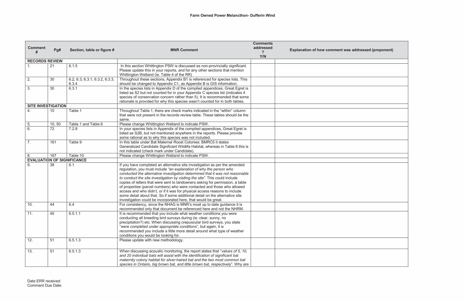
RECORDS REVIEW 1. 21 6.1.5 In this section Whittington PSW is discussed as non-provincially significant.
Please update this in your reports, and for any other sections that mention Whittington Wetland (ie. Table 4 of the RR)
2. 30 6.2, 6.3, 6.3.1, 6.3.2, 6.3.3, 6.3.4
Throughout these sections, Appendix B1 is referenced for species lists. This should be changed to Appendix C1, as Appendix B is GIS information.
3. 30 6.3.1 In the species lists in Appendix D of the compiled appendices, Great Egret is listed as S2 but not counted for in your Appendix C species list (indicates 4 species of conservation concern rather than 5). It is recommended that some rationale is provided for why this species wasn’t counted for in both tables.
SITE INVESTIGATION 4. 10 Table 1 Throughout Table 1, there are check marks indicated in the “within” column
that were not present in the records review table. These tables should be the same.
5. 10, 50 Table 1 and Table 6 Please change Whittington Wetland to indicate PSW. 6. 72 7.2.8 In your species lists in Appendix of the compiled appendices, Great Egret is
listed as S2B, but not mentioned anywhere in the reports. Please provide some rational as to why this species was not included.
7. 161 Table 9 In this table under Bat Maternal Roost Colonies: BMRC5 it states Generalized Candidate Significant Wildlife Habitat, whereas in Table 8 this is not indicated (check mark under Candidate).
8. 167 Table 10 Please change Whittington Wetland to indicate PSW. EVALUATION OF SIGNIFICANCE 9. 38 6.1 If you have completed an alternative site investigation as per the amended
regulation, you must include “an explanation of why the person who conducted the alternative investigation determined that it was not reasonable to conduct the site investigation by visiting the site”. This could include copies of letters that were sent to landowners asking for permission, a table of properties (parcel numbers) who were contacted and those who allowed access and who didn’t, or if it was for physical access reasons to include some detail about that. So if some additional detail on the alternative site investigation could be incorporated here, that would be great.
10. 44 6.4 For consistency, since the NHAG is MNR’s most up to date guidance it is recommended only that document be referenced here and not the NHRM.
11. 45 6.5.1.1 It is recommended that you include what weather conditions you were conducting all breeding bird surveys during (ie. clear, sunny, no precipitation?) etc. When discussing crepuscular bird surveys, you state “were completed under appropriate conditions”, but again, it is recommended you include a little more detail around what type of weather conditions you would be looking for.
12. 51 6.5.1.3 Please update with new methodology.
13. 51 6.5.1.3 When discussing acoustic monitoring, the report states that “values of 5, 10, and 20 individual bats will assist with the identification of significant bat maternity colony habitat for silver-haired bat and the two most common bat species in Ontario, big brown bat, and little brown bat, respectively”. Why are

Farm Owned Power Melancthon- Dufferin Wind
Date ERR received: Comment Due Date:
Comment # Pg# Section, table or figure # MNR Comment
Comments addressed
?Y/N
Explanation of how comment was addressed (proponent)
these the only species that will be identifies using this method? It is recommended you include some additional information for why this study is effective for these bats and not others.
14. 84-98,162-163
8.1, Table 4, Table 7 There appears to be some discrepancies between the wetlands grouped in section 8.1 (and Table 4) and Table 7. In section 8.1, Wetland ID 21 and Wetland ID 51 are listed as Previously Evaluated Provincially Significant Wetland units, however these are also included in table 4 as having a rapid assessment conducted. Why were rapid assessments conducted on these wetland areas?
In Table 7, Wetland ID 49, 50 and 50 are indicated as not significant, when in section 8.1 they are listed as Previously Evaluated Provincially Significant Wetland units.
In Table 7, Wetland ID 67, 69, and 70 are listed as treated as significant, significant, and significant, respectively, whereas in section 8.1 they are listed as Previously Evaluated Non-Provincially Significant Wetland units. Were these re-evaluated?
On page 85, Wetland ID 14 and 15 are listed as Unevaluated Wetland Units but are not included in the rapid assessment table. Why were these left out?
15. 85 8.1 At the end of page 85 it states “Unevaluated wetlands assessed in Table 4 are assumed to be provincially significant…” It is recommended this language be changed to say “treated as” for consistency and as per the guidance in Appendix C of the NHAG.
16. 117 8.3 Same comment as previous.
17. 118 8.3 Under Open Country Breeding Bird Habitat you have listed OCBB17. I believe this should be OCBB16 as that is what is listed in the table.
18. 118 8.3 It is recommended you provide a little more information on the generalized candidate SWH from the NHAG. Ie. What this means for these habitats and what you will be doing for the EIS, since they are not really discussed again.
ENVIRONMENTAL IMPACT STUDY 19. 10 4 Similar to previous comments, it is recommended that “assumed provincially
significant” be changed to “treated as” as per Appendix C of the NHAG.
20. 10 Table 1 In the EIS it is not necessary to include a full table of all features significant and non-significant. It is recommended you only include those features that are carried over to this report.
21. 16 Table 1 Within this table, Wetland ID 49, 50 and 51 are listed as not- provincially significant and therefore no EIS required. In the EoS report section 8.1, these same three wetland units are listed as Previously Evaluated Provincially Significant Wetlands. Please explain the discrepancy/ provide some rationale for the change.

Farm Owned Power Melancthon- Dufferin Wind
Date ERR received: Comment Due Date:
Comment # Pg# Section, table or figure # MNR Comment
Comments addressed
?Y/N
Explanation of how comment was addressed (proponent)
22. 88 Table 3 Under Power Line Installation 230 kV Option, please change “assumed Provincially Significant” to “treated as”.
23. 97 Table 5 Please revise title of table to say “treated as”.
24. 109 8.2.3 In this section you are referencing Table 6 for woodlands. There is actually a Table 6a and a 6b both for woodlands, so it is recommended that the reference be updated to include both tables.
25. 152, 156 Table 8 and Table 8 Here you have two tables in a row, both Table 8.
26. 156-194 Table 8 MITIGATION MEASURES
Under mitigation measures, its states “Develop and implement an erosion and sediment control (ESC) plan prior to site preparation…” It is recommended that when you are using this ESC as a mitigation measure you also include a little more detail about what the ESC might entail. For example “Develop and ESC plan based on [contractors plans etc] which might include [silt fencing around work area and any stockpiled or excavated materials to prevent runoff into adjacent areas etc.] to protect surrounding areas.” This way you are at least detailing some of the techniques you may be using rather than just stating a plan will be made at a later date.
The same is recommended for the grading and flow management plan.
It is recommended under mitigation for the loss of any woodland that you include monitoring of the new woodland edge for dieback and to have a plan in place in case this occurs. This could also be included in Table 9.
Throughout the table it is recommended that any areas are re-seeded with native vegetation as part of your mitigation.
Throughout the table it is recommended that clearly demarcating the boundaries of the constructible area is added to ensure construction crews do not pass into significant habitats, sensitive areas etc. (Ex. Minimize removal of woodland vegetation and avoid displacement of woodland interior where possible- by clearly demarcating boundaries and having construction crews aware they are not to pass into those areas. Maximize the distance of all construction equipment used from the woodland edge; operate machinery in the areas disturbed for construction only- by setting clear boundaries around work areas and marking them etc.)
RESIDUAL EFFECTS
In this column it is recommended that you include a little more rationale for why there would not be any negative impacts, especially for those features that you are encroaching on or within 30 m of (with the exception of

Farm Owned Power Melancthon- Dufferin Wind
Date ERR received: Comment Due Date:
Comment # Pg# Section, table or figure # MNR Comment
Comments addressed
?Y/N
Explanation of how comment was addressed (proponent)
overhead lines and directional drilling). So for example, If you are planning on clearing and grubbing within 3 m of a wetland treated as significant, more information is required as to why this would be a sufficient buffer to avoid any negative impacts (Ex. Minimal impacts to the feature based on literature, recommended buffers, mitigation measures, no impacts to the function based on construction activities etc.)
OTHER
Under Duration of Effect for Wetland 7,8,9& 33, ABH 9, it states “during construction only”. It also stated there is going to be an access road constructed. It is recommended that some clarification is provided around the lifespan of the access road.
Under Open Country Breeding Bird Habitat, the first row is missing a name under Significant Natural Feature Affected by Activity.
27. 208 13 Please change “assumed” to “treated as”.


Ministry of Ministère des Natural Resources Richesses naturelles
Renewable Energy Operations Team P.O Box 7000 300 Water Street 4th Floor, South Tower Peterborough, ON K9J 8M5
May 9, 2012
Dufferin Wind Power Inc. TD Canada Trust Tower 161 Bay Street, Suite 4550 Toronto, ONM5J 2S4
RE: NHA Confirmation for Dufferin Wind Farm
Dear Jeff Hammond:
In accordance with the Ministry of the Environment’s (MOE’s) Renewable Energy Approvals (REA) Regulation (O.Reg.359/09), the Ministry of Natural Resources (MNR) has reviewed the natural heritage assessment and environmental impact study for the Dufferin Wind Farm located in the Township of Melancthon in Dufferin County, the final version of which was submitted by Dufferin Wind Power Inc. on May 9, 2012.
In accordance with Section 28(2) and 38(2)(b) of the REA regulation, MNR provides the following confirmations following review of the natural heritage assessment:
1. The MNR confirms that the determination of the existence of natural features and the boundaries of natural features was made using applicable evaluation criteria or procedures established or accepted by MNR.
2. The MNR confirms that the site investigation and records review were conducted using applicable evaluation criteria or procedures established or accepted by MNR, if no natural features were identified.
3. The MNR confirms that the evaluation of the significance or provincial significance of the natural features was conducted using applicable evaluation criteria or procedures established or accepted by MNR.
4. The MNR confirms that the project location is not in a provincial park or conservation reserve.
5. The MNR confirms that the environmental impact assessment report has been prepared in accordance with procedures established by the MNR.
In accordance with Appendix D of MNR’s Natural Heritage Assessment Guide, a commitment has been made to complete pre-construction assessments of habitat use

for candidate significant wildlife habitats. MNR has reviewed and confirmed the assessment methods and the range of mitigation options. Pending completion of the pre-construction assessments and determination of significance, the appropriate mitigation is expected to be implemented, as committed to in the environmental impact study for the following candidate significant wildlife habitats:
� Colonial Bird Nesting Habitat (feature CNH 6, 7, 12)� Waterfowl Nesting Habitat (feature WNH 4, 11-14, 16-18, 20-24) � Woodland Area Sensitive Forest Breeding Bird Habitat (feature IFB 9) � Open Country Breeding Bird Habitat (feature OCBB 11) � Marsh Breeding Bird Habitat (MBB 11, 13, 17, 18, 28, 31, 45) � Amphibian Woodland Breeding (features ABH 18, 27, 38, 48, 59)
As detailed within the NHA reports, 2 options are proposed for the transmission route associated with this project. A decision has not yet been made as to which option will be selected. The Alternative Option Package Appendix of the Environmental Impact Study describes that within the 2nd option there are alternative scenarios which, based on the outcome of wetland evaluations, will determine if construction can occur within the wetlands. If the proponent decides to pursue the option laid out in the Alternative Option Package, the following pre-construction assessments must take place. MNR has reviewed and confirmed the assessment methods at the range of mitigation options. Pending completion of the pre-construction assessments and determination of significance, the appropriate mitigation is expected to be implemented, as committed to in the Alternative Option Package of the environmental impact study for the following candidate significant wildlife habitats and wetlands:
� Colonial Bird Nesting Habitat (feature CNH 13, 14, 15)� Marsh Breeding Bird Habitat (MBB 30, 32, 33, 36-39, 42, 46, 49) � Amphibian Woodland Breeding (features ABH 30, 31, 34, 35, 37, 42, 48)� Wetlands (features 47, 48, 51-54, 56-61, 71, 72, 81)
In addition to the NHA, Environmental Effects Monitoring Plans that address post-construction monitoring and mitigation for birds and bats must be prepared and implemented. It is recommended that post-construction monitoring plans be prepared in accordance with MNR Guidelines and be reviewed by MNR in advance of submitting a REA application to MOE in order to minimize potential delays in determining if the application is complete.
This confirmation letter is valid for the project as proposed in the natural heritage assessment and environmental impact study, including those sections describing the Environmental Effects Monitoring Plan and Construction Plan Report. Should any changes be made to the proposed project that would alter the NHA, MNR may need to undertake additional review of the NHA.
Where specific commitments have been made by the applicant in the NHA with respect to project design, construction, rehabilitation, operation, mitigation, or monitoring, MNR expects that these commitments will be considered in MOE’s Renewable Energy Approval decision and, if approved, be implemented by the applicant.
In accordance with S.12 (1) of the Renewable Energy Approvals Regulation, this letter must be included as part of your application submitted to the MOE for a Renewable Energy Approval.

Please be aware that your project may be subject to additional legislative approvals as outlined in the Ministry of Natural Resources’ Approvals and Permitting Requirements Document. These approvals are required prior to the construction of your renewable energy facility.
If you wish to discuss any part of this confirmation or additional comments provided, please contact me at [email protected] or 613-732-5506.
Sincerely,
Amy Cameron Southern Region Renewable Energy Operations Team Coordinator Regional Operations Division Ministry of Natural Resources
cc. Mark Shoreman, District Manager, MNR Midhurst District cc. Brad Allan, A/Planning & Information Supervisor, MNR Midhurst District cc. Emily Gryck, Renewable Energy Planning Ecologist, MNR Southern Region cc. Narren Santos, Environmental Assessment and Approvals Branch, MOE cc. Sandra Guido, Environmental Assessment and Approvals Branch, MOE

Ministry of Tourism, Culture and Sport

April 25, 2012
Mr. Don McKinnonDillon Consulting Limited253 York Blvd. Suite 800Toronto, Ontario M2J 4Y8
RE: Dufferin Wind Farm Project, Dufferin County, Melancthon Township, FIT 000661-WIN-130-601, MTCS RIMS Number HD00669, P027-153-2011, P027-154-2011, P027-155-2011, P027-056-2011, P057-157-2011, P027-158-2011, P109-038-2010 &P006-015-2011
Dear Proponent:
This letter constitutes the Ministry of Tourism and Culture’s written comments as required by s. 22(3)(a) of O. Reg. 359/09 under the Environmental Protection Act regarding archaeological assessments undertaken for the above project.
Based on the information contained in the reports you have submitted for this project, the Ministry believes the archaeological assessment complies with the Ontario Heritage Act'slicensing requirements, including the licence terms and conditions and the Ministry's 1993 Archaeological Assessment Technical Guidelines or the 2011 Standards and Guidelines for Consultant Archaeologists (whichever apply). Please note that the Ministry makes no representation or warranty as to the completeness, accuracy or quality of the reports.*
The reports recommend the following:
Stage 1 Report, P027-153-2011, November 30, 2011, Received December 09, 2011, Satisfaction Letter Issued December 16, 2011
Stage 2 archaeological assessment is recommended for the areas identified in figures 8B, 8E and 8F. No further archaeological assessment is required for the remainder of this property.
The appropriate Stage 2 strategy for the area of archaeological assessment is test pitting. The areas of archaeological potential cannot be ploughed.
Ministry of Tourism,Culture and Sport
Culture Programs UnitPrograms & Services Br.900 Highbury AvenueLondon, ON N5Y 1A4Tel: 519-675-6898Fax: 519-675-7777e-mail: [email protected]
Ministère du Tourisme,de la Culture et du Sport
Unité des programmes culturelsDirection des programmes et des services900, av. HighburyLondon, ON N5Y 1A4Tél: 519-675-6898Téléc: 519-675-7777e-mail: [email protected]
2
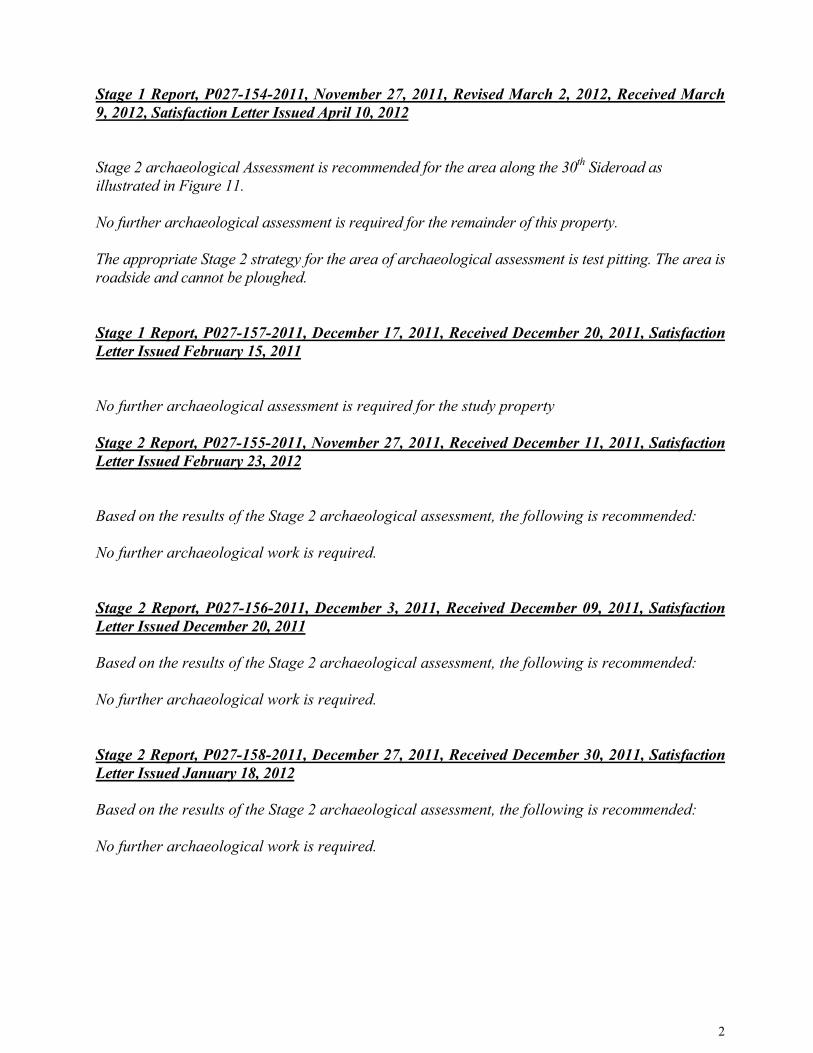
Stage 1 Report, P027-154-2011, November 27, 2011, Revised March 2, 2012, Received March 9, 2012, Satisfaction Letter Issued April 10, 2012
Stage 2 archaeological Assessment is recommended for the area along the 30th Sideroad as illustrated in Figure 11.
No further archaeological assessment is required for the remainder of this property.
The appropriate Stage 2 strategy for the area of archaeological assessment is test pitting. The area is roadside and cannot be ploughed.
Stage 1 Report, P027-157-2011, December 17, 2011, Received December 20, 2011, Satisfaction Letter Issued February 15, 2011
No further archaeological assessment is required for the study property
Stage 2 Report, P027-155-2011, November 27, 2011, Received December 11, 2011, Satisfaction Letter Issued February 23, 2012
Based on the results of the Stage 2 archaeological assessment, the following is recommended:
No further archaeological work is required.
Stage 2 Report, P027-156-2011, December 3, 2011, Received December 09, 2011, Satisfaction Letter Issued December 20, 2011
Based on the results of the Stage 2 archaeological assessment, the following is recommended:
No further archaeological work is required.
Stage 2 Report, P027-158-2011, December 27, 2011, Received December 30, 2011, Satisfaction Letter Issued January 18, 2012
Based on the results of the Stage 2 archaeological assessment, the following is recommended:
No further archaeological work is required.

3
Stage 1-2 Report, P109-038-2010 &P006-015-2011, December 21, 2011, Revised April 13, 2012, Received April 17, 2012, Satisfaction Letter Issued April 25, 2012
Stage 1 RecommendationsDue to the potential for encountering archaeological resources, it is recommended that archaeological assessment (Stage 2) be conducted for all turbine sites, as well as ancillary facilities such as access roads, underground cable alignments, collector lines, lay-down yards, transmission lines, the proposed substation site, the proposed point of interconnect etc, well in advance of any ground disturbance.
There are only a few exceptions to the above recommendation. The first would be those areas previously subjected to archaeological assessment and for which no further archaeological assessment is required by the Ontario Ministry of Tourism, Culture and Sport (Figure 6). It should also be noted that all swamp and road crossings have been examined and determined to exhibit low archaeological potential (i.e. swamps and municipal roadways), and as such no further archaeological assessment is required. Furthermore, these areas are to be addressed by means of Horizontal Directional Drilling (HDD) (See Appendix A for charts, photos and detailed maps that show areas of low potential that are to be HDD). Finally, there are several areas where the underground cable alignments will be placed in the ditch running alongside municipal roadways. Given their low archaeological potential on the basis of previous disturbance, CRM Group recommends that no further archaeological assessment is required for these ditches (See Appendix A for detailed maps and photos that show areas of low potential such as ditches).
To facilitate visual assessment (Stage 2) of the proposed turbine sites, as well as ancillary facilities such as access roads, underground cable alignments, collector lines, lay-down yards, transmission lines, the proposed substation site, the point of interconnect, etc, it is recommended these impact zones, when possible, be ploughed and allowed to weather prior to conducting the assessment. Please note that all ploughing should be conducted within the standards of normal agricultural ploughing (no chisel ploughing or deep ploughing) so as not to disturb archaeological resources buried below the current plough zone.
Stage 2 RecommendationsOf the 53 turbine locations (including 4 alternate locations) assessed by CRM Group, 43were devoid of any observable cultural resources, as well as the proposed substation and point of interconnect. Isolated finds were made in conjunction with 2 of the proposed turbine locations. Substantial cultural resource finds were made in conjunction with 8 proposed turbine locations (including 1 alternate location) or their access roads (Table3.2). Of these eight sites, two require Stage 3 archaeological testing, while CRM Group recommends no further archaeological assessment is required on the remaining six sites.
Within the seven portions of the 230kv transmission line alignment assessed by CRMGroup, all were devoid of any observable cultural material. The transmission line does not require any further archaeological assessment.
Recognizing the significance of the historic and Precontact archaeological resources identified as a result of the archaeological assessment, the client is working with Dillon Consulting Ltd and CRM Group to avoid or minimize construction related impacts through repositioning of turbine sites and the realignment of access roads whenever possible.

4
On the basis of discoveries made during the assessment in conjunction with site specific historical analysis, CRM Group makes the following recommendations:
1. No Further Archaeological Assessment Required of those Areas Containing NoCultural Resources:
Given the absence of observable cultural resources on all facilities associated withturbine sites T1 &T2, T3 & T4 & T5 & T6 & T7 & T8, T9, T10 & T12, T 13&T14, T15 & T16, T17 & T18, T19 & T20, T21 & T22, T23, T25, T26, T27, T28,T29, T30, T32, T33, T34, T36, T37, T40, T41, T42, T44, T45, T46 & T47, T49,AT2, AT3, AT4, the O & M building, the substation and the point of interconnect,CRM Group recommends that no further archaeological assessment is required on these 43 individual turbine sites, access roads, collector lines, staging areas, turnaround points, bump outs, proposed substation site and point of interconnect.
CRM Group also recommends that no further archaeological assessment is required for the following portions of transmission line: from 4th Line to turbine site T24, the 25m corridor in the woodlot east of turbine site T24, the swath paralleling County Road 21 between turbine site T42 and 5th Line, from 5th Line to 8th Line NE, from the 5th Line wetland west of T41, from the north-western corner of the wetland to the end of 6th Line NE, and the shovel tested area of line paralleling the access road to T41.
2. No Further Archaeological Assessment Required of those Turbine SitesContaining Isolated Finds:Given the isolated context in which either formal tools or flakes were located within facilities associated with T38 and T35, CRM Group recommends that no further archaeological assessment is required on the turbine sites, access roads, collector lines, turnaround points, bump outs and staging areas associated with these two turbine sites.
3. Turbine Site T11Given the modern (late nineteenth to early twentieth century) dating of the cultural resources recovered from this site, CRM Group recommends that no further archaeological assessment is required for turbine site T11 and its associated parts.
4. Turbine Site T24Given the only cultural resource identified on turbine site T24 is a twentieth century refuse dump, CRM Group recommends that no further archaeological assessment is required for turbine site T24 and its associated parts.
5. Turbine Site T39Given the extremely small number of artifacts recovered (n=2 flakes), as well as the absence of any diagnostic artifacts, CRM Group recommends that no further archaeological assessment is required for turbine site T39 and its associated parts.

5
6. Turbine Site T48Given the modern (twentieth century) dating of the cultural resources recovered from this site, CRM Group recommends that no further archaeological assessment is required for turbine site T48 and its associated parts.
7. MET TowerGiven the very small and sparse nature of the scatter, as well as the modern (twentieth century) dating of the cultural resources recovered from this site, CRM Group recommends that no further archaeological assessment is required for the MET tower and its associated parts.
8. Alternate Turbine Site AT1Given the only cultural resource identified on alternate turbine site AT1 is a late nineteenth century refuse dump, CRM Group recommends that no further archaeological assessment is required for alternate turbine site 1 and its associated parts.
9. Turbine Site T31Given the requirements for Stage 3 Testing and site avoidance as stipulated in theOM CTS’s 2011 Standards and Guidelines for Consultant Archaeologists, CRMGroup recommends that the significant archaeological resources found within theT31 turbine site including the 20 metre buffer and 21 metre to 70 metre monitoring zone be avoided if possible.
If development impacts the monitoring zone (that area falling between 21 metres and 70 metres beyond the identified perimeter of the site), CRM Group recommends archaeological construction monitoring.
CRM Group recommends that temporary fencing be erected along the outer limits of the monitoring zone (greater than 71 metres beyond the identified perimeter of the site) to prevent any accidental impact associated with construction activities during development of the turbine site. A licensed archaeologist must also be present during development of this area to monitor the boundaries of the site.
If development impacts the site proper and/or the 20 metre buffer, the site identified within the T31 turbine pad must be subjected to Stage 3 archaeological assessment. The Stage 3 assessment of this site (or part of site and buffer area located within the project location) would include historic background research, a CSP and the excavation of test units at a five metre grid across the site location and an additional 20% of units that will focus on areas of interest within the site extent. Construction monitoring of the buffered site area may still be required depending on the amount of Stage 3 completed, the results of the Stage 3 survey, and the overall location of the site with respect to the project location. Stage 4 archaeological excavation may be required for areas of the site as well, depending on the results of the Stage 3 archaeological assessment.
CRM Group recommends that no further archaeological assessment is required for the remainder of the T31 turbine site (that area falling 71 metres or more beyond the identified perimeter of the site).

6
Site 1 of Turbine Site T31 is a very small post contact site, and it is not yet evident that the level of cultural heritage value and interest will result in a recommendation to proceed to Stage 4 archaeological assessment.
10. Turbine Site T43Given the requirements for Stage 3 Testing and site avoidance as stipulated in theOM CTS’s 2011 Standards and Guidelines for Consultant Archaeologists, CRMGroup recommends that the significant archaeological resources found within theT43 turbine site including the 20 metre buffer and 21 metre to 70 metre monitoring zone be avoided if possible.
If development impacts the monitoring zone (that area falling between 21 metres and 70 metres beyond the identified perimeter of the site), CRM Group recommends archaeological construction monitoring.
CRM Group recommends that temporary fencing be erected along the outer limits of the monitoring zone (greater than 70 metres beyond the identified perimeter of the site) to prevent any accidental impact associated with construction activities during development of the turbine site. A licensed archaeologist must also be present during development of this area to monitor the boundaries of the site. If development impacts the site proper and/or the 20 metre buffer, the site identified within the T43 turbine pad must be subjected to Stage 3 archaeological assessment. The Stage 3 assessment of this site (or part of site and buffer area located within the project location) would include historic background research, a CSP and the excavation of test units at a five metre grid across the site location and an additional 20% of units that will focus on areas of interest within the site extent. Construction monitoring of the buffered site area may still be required depending on the amount of Stage 3 completed, the results of the Stage 3 survey, and the overall location of the site with respect to the project location. Stage 4 archaeological excavation may be required for areas of the site as well, depending on the results of the Stage 3 archaeological assessment.
CRM Group recommends that no further archaeological assessment is required for the remainder of the T43 turbine site (that area falling 71 metres or more beyond the identified perimeter of the site).
Site 1 of Turbine Site T43 is a small post contact site, and it is not yet evident that the level of cultural heritage value and interest will result in a recommendation to proceed to Stage 4 archaeological assessment.
The Ministry is satisfied with these recommendations.
This letter does not waive any requirements which you may have under the Ontario Heritage Act.A separate letter addressing archaeological licensing obligations under the Act will be sent to the archaeologist who completed the assessment and will be copied to you.
This letter does not constitute approval of the renewable energy project. Approvals of the project may be required under other statutes and regulations. It is your responsibility to obtain any necessary approvals or licences.

7
Please feel free to contact me if you have questions or require additional information.
Sincerely,
Shari ProwseArchaeology Review Officer
cc. Dr. Scarlett Janusas, Archaeological Heritage and Consulting and EducationDr. Tom Arnold, Cultural Resources Management Group LimitedMr. Bruce Stewart, Cultural Resources Management Group Limited
* In no way will the Ministry be liable for any harm, damages, costs, expenses, losses, claims or actions that may result: (a) if the Report(s) or its recommendations are discovered to be inaccurate, incomplete, misleading or fraudulent; or (b) from the issuance of this letter. Further measures may need to be taken in the event that additional artifacts or archaeological sites are identified or the Report(s) is otherwise found to be inaccurate, incomplete, misleading or fraudulent.
Ministry of Tourism, Culture and Sport
Culture Services Unit Programs and Services Branch Culture Division 401 Bay Street, Suite 1700 Toronto ON M7A 0A7 Tel: 416.314.3108 Fax: 416.314.7175
Ministère du Tourisme, de la Culture et du Sport
Unité des services culturels Direction des programmes et des services Division de culture 401, rue Bay, bureau 1700 Toronto ON M7A 0A7 Tél: 416.314.3108 Téléc: 416.212.7175
18 May 2012
Jeff Hammond, Project Director Dufferin Wind Power Inc. TD Canada Trust Tower 161 Bay Street, Suite 4550 Toronto, Ontario M5J 2S4
Dear Mr. Hammond:
Project : Wind Farm, Two Transmission Lines, Point of Interconnection and Substation Proponent : Dufferin Wind Power Inc. Location : Multiple Lots in Dufferin County (Townships of Amaranth, Mulmur and Melancthon,
and Town of Mono) FIT Contract No. : F-000661-WIN-130-601 MTCS File No. : 22EA013
This letter constitutes the Ministry of Tourism, Culture and Sport’s written comments as required by s. 23(3)(a) of O. Reg. 359/09 under the Environmental Protection Act regarding heritage assessments undertaken for the above project.
Based on the information contained in the report you have submitted for this project, the Ministry is satisfied with the heritage assessment. Please note that the Ministry makes no representation or warranty as to the completeness, accuracy or quality of the heritage assessment report. *
The report recommends the following:
10.0 MITIGATION RECOMMENDATIONS
As per the Environmental Protection Act – O. Reg. 359/09 (Government of Ontario 2009:2), an evaluation of any impact of the renewable energy project on any heritage resources which may exist on or abutting the property and proposed measures to avoid, eliminate or mitigate the impact, are made herein.
The two built features are not considered to be significant heritage features, are not recommended for designation and no mitigation recommendations are required.
There are no identified cultural landscapes on the project areas.
There are no recommendations with respect to the cultural heritage assessment of the Dufferin Wind Farm.
The Ministry is satisfied with these recommendations.
1 of 2

2 of 2
This letter does not waive any requirements which you may have under the Ontario Heritage Act. Also, this letter does not constitute approval of the renewable energy project. Approvals of the project may be required under other statutes and regulations. It is your responsibility to obtain any necessary approvals or licences.
Please feel free to contact me if you have questions or require additional information.
Sincerely,
Katherine Kirzati Heritage Planner 416.314.7643 [email protected]
cc. Scarlett Janusas Archaeological and Heritage Consulting and Education
Chris Schiller, Manager Culture Services Unit Ministry of Tourism and Culture
Sandra Guido, Senior Program Support Coordinator Approval Services Unit Ministry of the Environment
* In no way will the Ministry be liable for any harm, damages, costs, expenses, losses, claims or actions that may result: (a) if the Report(s) or its recommendations are discovered to be inaccurate, incomplete, misleading or fraudulent; or (b) from the issuance of this letter. Further measures may need to be taken in the event that additional artifacts or heritage resources are identified or the Report(s) is otherwise found to be inaccurate, incomplete, misleading or fraudulent.

Conservation Authorities