Embed Size (px)
Citation preview
© 2014 Pearson Education, Inc.
MAPS … Then and Now
© 2014 Pearson Education, Inc.
Learning Target
I can describe how human geography examines both “where” and “why” questions about activities and people on earth
I can explain how geographers use maps to describe where things are.
© 2014 Pearson Education, Inc.
What are Maps?
Two-dimensional or flat-scale model of Earth’s surface
Cartography is the science of mapmaking.
Maps serve two purposes…
1. As a REFERENCE TOOL - identify an object’s absolute and relative location.
2. As a COMMUNICATIONS TOOL - convey the distribution of human activities or physical features.
© 2014 Pearson Education, Inc.
Maps – THEN…
Navigation devices to show a traveler how to get from Point A to Point B.
First world map prepared by Eratosthenes (era-toss-ta-nees) (276–194 B.C.)
Improvements to world map later made by Ptolemy – Greek Scholar.
After Ptolemy, advancements by Chinese and Islamic world.
Mapmaking revived during the Age of Exploration and Discovery.

© 2014 Pearson Education, Inc.
Contemporary Mapping - NOW
© 2014 Pearson Education, Inc.
Learning Target
I can summarize the history of geography
I can describe the role of map scale and projections in making maps.

© 2014 Pearson Education, Inc.
Map Scale Level of detail and the amount of area
covered on the map depend on its map scale. Map Scale - Relationship of a feature’s
size on a map to its actual size on Earth
Map scale is presented in three ways…1. Ratio or Fraction Scale: Ex. 1:24,000
or
1 (One Unit of Distance) /24,000 /(Unit of Distance on Earth’s Surface)
© 2014 Pearson Education, Inc.
2. Written Scale: Ex. 1 inch equals 1 mile
Number on left is one unit of distance, while number on right represents a different unit of distance on Earth’s surface.
3. Graphic Scale: Usually consists of a bar line marked to show distance on Earth’s surface
Distance between two points can be overlaid on the scale bar to determine the distance on Earth’s surface.
© 2014 Pearson Education, Inc.
Projection Scientific method of transferring locations on
Earth’s surface to a flat map is called projection.
Causes distortion when drawing it on a flat piece of paper.
Four types of distortion
1. Shape of an area can be distorted.
2. Distance between points may become increased or decreased.
3. Relative size of different areas can be altered.
4. Direction between points can be distorted.
© 2014 Pearson Education, Inc.
Map Projections and Distortion
http://media.pearsoncmg.com/bc/bc_0media_geo/map_projections/noqzs/main.html

© 2014 Pearson Education, Inc.
Compare the sizes of Greenland and South America on these maps. Which of the two landmasses is actually larger?
© 2014 Pearson Education, Inc.
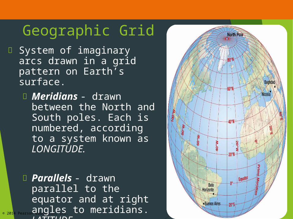
Geographic Grid System of imaginary arcs
drawn in a grid pattern on Earth’s surface. Meridians - drawn
between the North and South poles. Each is numbered, according to a system known as LONGITUDE.
Parallels - drawn parallel to the equator and at right angles to meridians. LATITUDE
© 2014 Pearson Education, Inc.
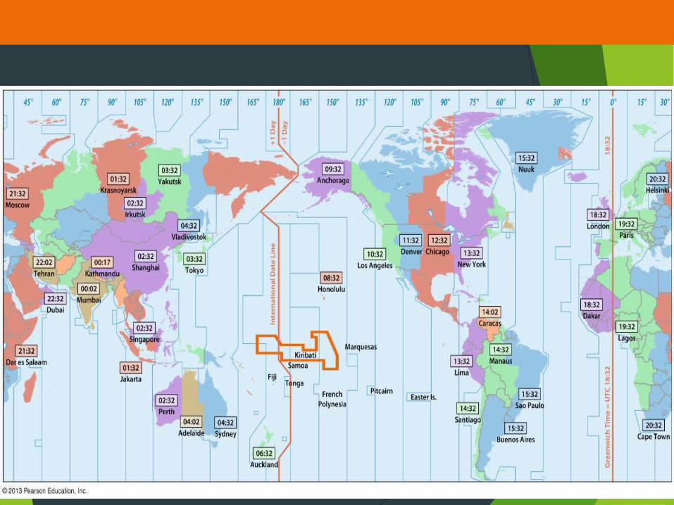
Telling Time Earth as a sphere is divided into 360º of
longitude.
Divide 360º by 24 time zones (one for each hour of day) equals 15º.
Each 15º band of longitude is assigned to a standard time zone.
Greenwich Mean Time (GMT) is…
Located at the prime meridian (0º longitude).
Master reference time for all points on Earth.
© 2014 Pearson Education, Inc.

© 2014 Pearson Education, Inc.
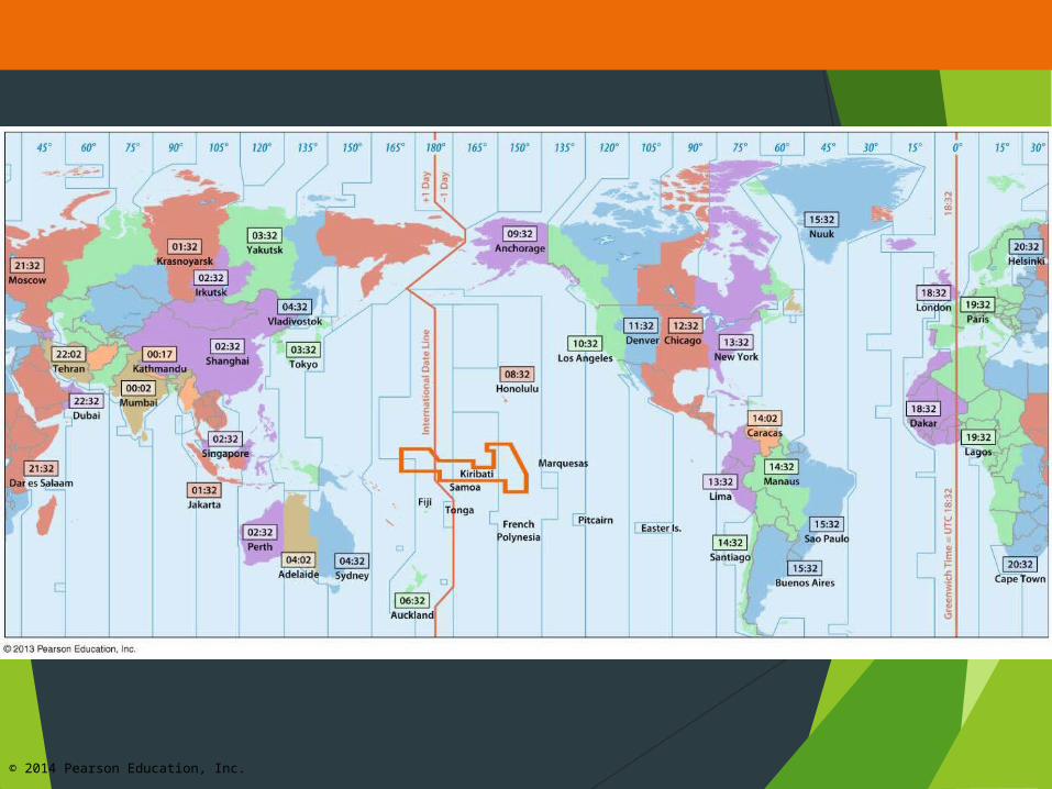
Telling Time The International Date Line is…
Located at 180º longitude.
Position deviates from 180º longitude at times to accommodate various nearby nation-states.
Point you move the clock back 24 hours (one day), if you are heading eastward toward America.
Point you move the clock ahead 24 hours (one day), if you are heading westward toward Asia.
© 2014 Pearson Education, Inc.

© 2014 Pearson Education, Inc.
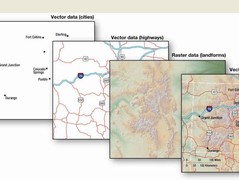
Contemporary Tools – GIS
Geographic Information Science (GIScience) involves the development and analysis of data about Earth acquired through satellite and other electronic information technologies.
Collecting Data: Remote Sensing
© 2014 Pearson Education, Inc.

© 2014 Pearson Education, Inc.
Contemporary Tools - GPS
Pinpointing Locations: Global Positioning System (GPS)
System that accurately determines the precise position of something on Earth
GPS in the U.S. includes 3 elements:
Satellites placed in predetermined orbits by the U.S. military (24 in operation and 3 in reserve)
Tracking stations to monitor and control the satellites.
A receiver that can locate at least 4 satellites, figure out the distance to each, and use this information to pinpoint its own location.


![Iterated a-NGSM Maps Systems* · ITERATED a-NGSM MAPS AND ]" SYSTEMS 3 n > 0 then the iterated composition of k a-NGSM maps from U (with repetition possible) can unambiguously be](https://img.pdfslide.us/doc/110x75/5e3228c3a4910c1b1f722f7f/iterated-a-ngsm-maps-systems-iterated-a-ngsm-maps-and-systems-3-n-.jpg)
![Zeta-functions for expanding maps and Anosov flowsruelle/PUBLICATIONS/[45].pdf · Zeta-Functions for Expanding Maps and Anosov Flows 233 norm, then dl , d 2 extend to entire Junctions](https://img.pdfslide.us/doc/110x75/5b9ede1c09d3f2ab0b8ca2d7/zeta-functions-for-expanding-maps-and-anosov-ruellepublications45pdf-zeta-functions.jpg)


![mmco- OF INDUCING ONTO GLOBAL MAPSglobal maps on C,(S) of a is onto, then they are one-to-one [I], a2d if the global maps of o are one-to-one, then the global maps on C&J of u are](https://img.pdfslide.us/doc/110x75/600a4f423f208c65fb1523b8/mmco-of-inducing-onto-global-maps-global-maps-on-cs-of-a-is-onto-then-they.jpg)