Embed Size (px)
Citation preview

®
© 2011 Open Geospatial Consortium, Inc.
FAA Special Activity Airspace (SAA) Dissemination
OGC PilotNadine Alameh, OGC; Initiative Director
Johannes Echterhoff, iGSI, OGC IPTeam; Initiative [email protected]

OGC®
OGC at a Glance (1)
• Founded in 1994, not for profit, consensus based and voluntary• Over 416 member organizations (industry, government, academia) (January 2011)
http://www.opengeospatial.org/ogc/members• 30+ adopted OGC Standards (some are ISO Standards)
http://www.opengeospatial.org/standards• Several hundred software products, implementing OGC Standards
http://www.opengeospatial.org/resource/products• Broad user community worldwide, many policy positions for NSDI based on OGC
standards• Cooperation with other standards organizations and foundations, e.g. ISO, W3C, OMG,
etc http://www.opengeospatial.org/ogc/alliancepartners
The Open Geospatial Consortium (OGC) is a non-profit, international voluntary consensus standards organization that is leading the development, promotion and harmonization of standards for geospatial and location based services.
2Copyright © 2011 Open Geospatial Consortium
OGC®
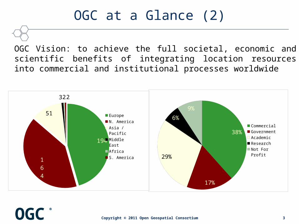
OGC at a Glance (2)
194
164
51
322
Europe
N. America
Asia / Pacific
Middle East
Africa
S. America
38%
17%
29%
6%
9%
Commercial
Government
Academic
Research
Not For Profit
OGC Vision: to achieve the full societal, economic and scientific benefits of integrating location resources into commercial and institutional processes worldwide
3Copyright © 2011 Open Geospatial Consortium

Making Location Count...
OGC’s Approach for Advancing Interoperability
• Interoperability Program (IP) - a global, innovative, hands-on rapid prototyping and testing program designed to unite users and industry in accelerating interface development and validation, and the delivery of interoperability to the market
• Specification Development Program –Consensus standards process similar to other Industry consortia (World Wide Web Consortium, OMA etc.).
• Outreach and Community Adoption Program – education and training, encourage take up of OGC specifications, business development, communications programs
• Compliance Testing and Certification Program - allows organizations that implement an OGC standard to test their implementations with the mandatory elements of that standard
4Copyright © 2011 Open Geospatial Consortium
OGC®
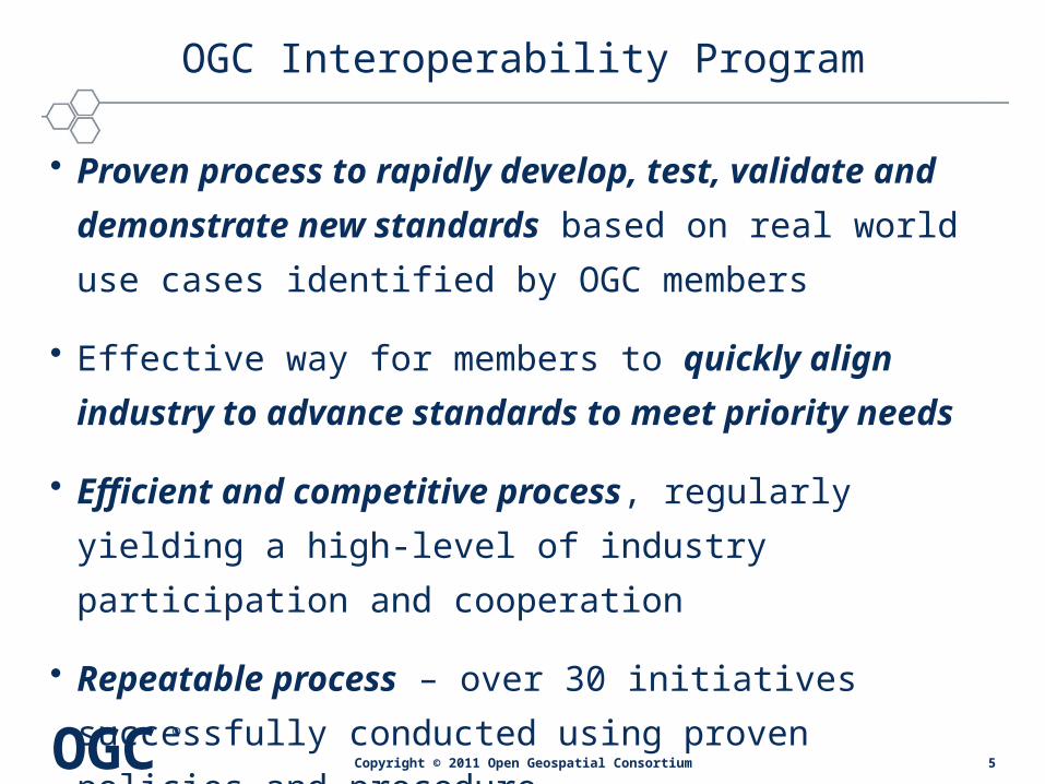
OGC Interoperability Program
• Proven process to rapidly develop, test, validate and
demonstrate new standards based on real world use
cases identified by OGC members
• Effective way for members to quickly align industry to
advance standards to meet priority needs
• Efficient and competitive process, regularly yielding a
high-level of industry participation and cooperation
• Repeatable process – over 30 initiatives successfully
conducted using proven policies and procedure
5Copyright © 2011 Open Geospatial Consortium
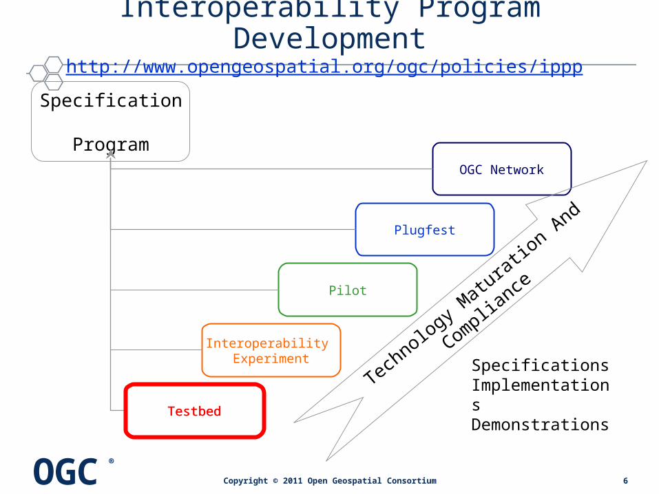
OGC®
Interoperability Experiment
Plugfest
OGC Network
Pilot
Specification Program
Tech
nology Matura
tion A
nd Complia
nce
Testbed
SpecificationsImplementationsDemonstrations
Interoperability Program Developmenthttp://www.opengeospatial.org/ogc/policies/ippp
Testbed
6Copyright © 2011 Open Geospatial Consortium

OGC®
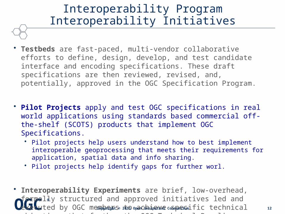
Interoperability Program Interoperability Initiatives
• Testbeds are fast-paced, multi-vendor collaborative efforts to define, design, develop, and test candidate interface and encoding specifications. These draft specifications are then reviewed, revised, and, potentially, approved in the OGC Specification Program.
• Pilot Projects apply and test OGC specifications in real world applications using standards based commercial off-the-shelf (SCOTS) products that implement OGC Specifications.
• Interoperability Experiments are brief, low-overhead, formally structured and approved initiatives led and executed by OGC members to achieve specific technical objectives that further the OGC Technical Baseline.
Copyright © 2011 Open Geospatial Consortium 7

OGC®
OGC Aviation Testbeds
• Sponsored by– FAA (AIM, SWIM and NNEW) and EUROCONTROL
• Focus– Validation and advancement of AIXM and WXXM– Delivery of Aeronautical and Weather information on-demand via OGC Web Services– Increased uptake by industry for AIXM and WXXM– Delivery of Standards-based Commercial Off-The-Shelf (SCOTS) products
• Challenges– Dealing with the (complex) temporality of aeronautical information – Dealing with metadata/lineage of information– Handling Digital NOTAMS – Events – Event content/Event filtering – Standardized styling of information– Encoding and filtering of 4D/5D weather information (e.g. radar data, weather forecasts, etc)
• Outcomes – Changes to AIXM/WXXM– Changes to OGC/ISO standards– SCOTS products on the market
8Copyright © 2011 Open Geospatial Consortium

OGC®
OGC Aviation Testbeds
• Aviation in OGC Web Services Testbed 6 OWS-6– http://www.opengeospatial.org/pub/www/ows6/index.html– Public Engineering Reports http://www.opengeospatial.org/standards/per – Outcomes
• Aviation Clients• Event Service• Change Requests to AIXM and Web Services
• Aviation in OGC Web Services Testbed 7 OWS-7– http://www.opengeospatial.org/pub/www/ows7/index.html– Public Engineering Reports: http://www.opengeospatial.org/standards/per – Outcomes
• Standards-compliant Commercial Off-The-Shelf products (SCOTS)• Open source validator• Portrayal• More Change Requests
9Copyright © 2011 Open Geospatial Consortium

OGC®
Aviation in OGC Web Services Testbed 8
• Kickoff Meeting– 9-11 March 11
• Final demonstration - Interoperability Day at OGC TC – 22 September 2011
• Final delivery (reports and videos)– 30 September 2011
10Copyright © 2011 Open Geospatial Consortium

OGC®
Interoperability Experiment
Plugfest
OGC Network
Pilot
Specification Program
Tech
nology Matura
tion A
nd Complia
nce
SpecificationsImplementationsDemonstrationsTestbed
Interoperability Program Developmenthttp://www.opengeospatial.org/ogc/policies/ippp
Pilot
11Copyright © 2011 Open Geospatial Consortium
OGC®
Interoperability Program Interoperability Initiatives
• Testbeds are fast-paced, multi-vendor collaborative efforts to define, design, develop, and test candidate interface and encoding specifications. These draft specifications are then reviewed, revised, and, potentially, approved in the OGC Specification Program.
• Pilot Projects apply and test OGC specifications in real world applications using standards based commercial off-the-shelf (SCOTS) products that implement OGC Specifications.• Pilot projects help users understand how to best implement interoperable
geoprocessing that meets their requirements for application, spatial data and info sharing.
• Pilot projects help identify gaps for further worl.
• Interoperability Experiments are brief, low-overhead, formally structured and approved initiatives led and executed by OGC members to achieve specific technical objectives that further the OGC Technical Baseline.
Copyright © 2011 Open Geospatial Consortium 12
OGC®
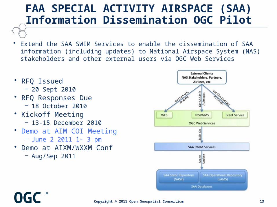
FAA SPECIAL ACTIVITY AIRSPACE (SAA) Information Dissemination OGC Pilot
• Extend the SAA SWIM Services to enable the dissemination of SAA information (including updates) to National Airspace System (NAS) stakeholders and other external users via OGC Web Services
• RFQ Issued– 20 Sept 2010
• RFQ Responses Due– 18 October 2010
• Kickoff Meeting– 13-15 December 2010
• Demo at AIM COI Meeting– June 2 2011 1- 3 pm
• Demo at AIXM/WXXM Conf– Aug/Sep 2011
13Copyright © 2011 Open Geospatial Consortium

OGC®
Team
Participants Organization/Team
Jim Perkins, Navin Vembar, Allen Proper FAA (sponsor organization)
Glen Landry, Kevin Lew FAA/CNA (sponsor representatives)
Nadine Alameh OGC
Mike Frey, Ken Gochenour, Dave Oscai Boeing/Jeppesen (US)
Steve Miller Concept Solutions (US)
Roger Brackin Envitia (UK)
David Burggraf Galdos (Canada)
Johannes Echterhoff iGSI (Germany), OGC IP Team
Thomas Everding Institute of Geoinformatics - U of Muenster (Germany)
Jeroen Dries Luciad (Belgium)
Christian Grothe, Daniel Bykowski, Barbara Glombiowska
Lufthansa Systems FlightNav (Switzerland)
Debbie Wilson, Daniel Hardwick, Ian Painter Snowflake (UK)
OGC®
Goals / Objectives
• Goals– Disseminate SAA information (including updates) to users via OGC Web Services
– Promote the implementation of adapters to support external stakeholders
• Objectives– Provide access to SAA information (including updates) via OGC Web Services
– Expose SAA information services to the NAS stakeholders with emphasis on airlines to automate flight dispatch and planning
– Develop architecture that can accommodate future requirements
Expose SAA information services to DoD systems to automate scheduling and information synchronization
15Copyright © 2011 Open Geospatial Consortium

OGC®
SAA Pilot Requirements
SAA Retrieval
• OGC WFS 2.0• AIXM SAA 5.1• static and
dynamic info
SAA Portrayal
• OGC FPS, WMS & SLD
• user-defined styles
• static and dynamic nature
SAA Update Notifications
• OGC Event Service
• SAA activation updates
• DNOTAM compliant
• notification according to user subscription criteria
16Copyright © 2011 Open Geospatial Consortium
OGC®
OGC Suite of Standards (1/2)
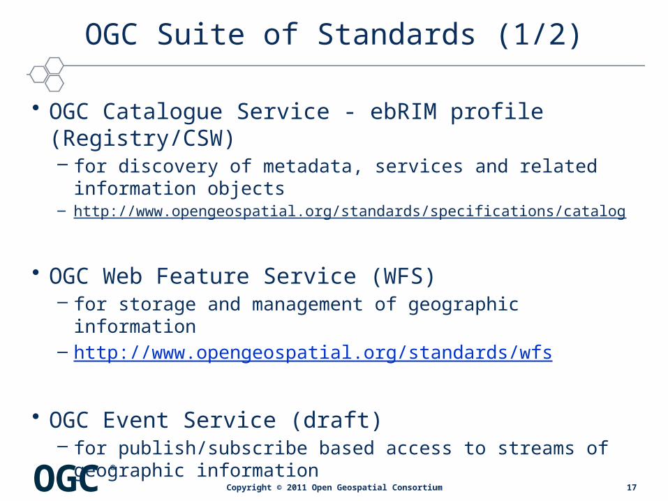
• OGC Catalogue Service - ebRIM profile (Registry/CSW)– for discovery of metadata, services and related information objects– http://www.opengeospatial.org/standards/specifications/catalog
• OGC Web Feature Service (WFS)– for storage and management of geographic information– http://www.opengeospatial.org/standards/wfs
• OGC Event Service (draft)– for publish/subscribe based access to streams of geographic
information
17Copyright © 2011 Open Geospatial Consortium
OGC®
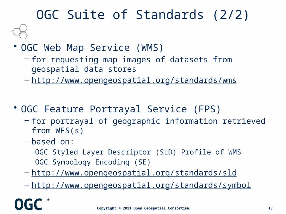
OGC Suite of Standards (2/2)
• OGC Web Map Service (WMS)– for requesting map images of datasets from geospatial data stores– http://www.opengeospatial.org/standards/wms
• OGC Feature Portrayal Service (FPS)– for portrayal of geographic information retrieved from WFS(s)– based on:
OGC Styled Layer Descriptor (SLD) Profile of WMS
OGC Symbology Encoding (SE)– http://www.opengeospatial.org/standards/sld – http://www.opengeospatial.org/standards/symbol
18Copyright © 2011 Open Geospatial Consortium
OGC®
Suite of Standards from Aviation Domain
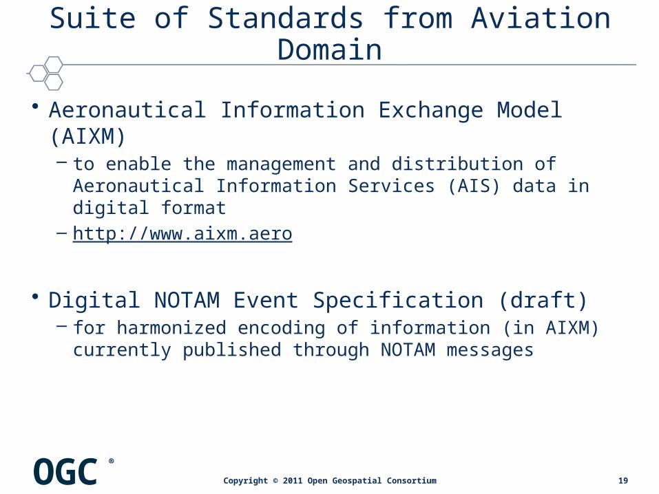
• Aeronautical Information Exchange Model (AIXM)– to enable the management and distribution of Aeronautical
Information Services (AIS) data in digital format– http://www.aixm.aero
• Digital NOTAM Event Specification (draft)– for harmonized encoding of information (in AIXM) currently
published through NOTAM messages
19Copyright © 2011 Open Geospatial Consortium

OGC®
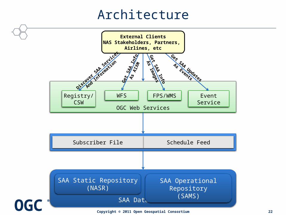
Architecture
SAA Databases
SAA Static Repository(NASR)
SAA Operational Repository(SAMS)
SAA SWIM Services
OGC Web Services
Bu
ild
on
Access
Up
date
External ClientsNAS Stakeholders, Partners,
Airlines, etc
20Copyright © 2011 Open Geospatial Consortium

OGC®
Architecture
SAA Databases
SAA Static Repository(NASR)
SAA Operational Repository(SAMS)
SAA SWIM Services
OGC Web Services
External ClientsNAS Stakeholders, Partners,
Airlines, etc
Subscriber File:
• SAA baseline data (Airspace geometry, Times of Use, Associated units, etc)
• AIXM 5.0• produced by NASR system• published in advance of effective date, provided on 28 day cycle
Schedule feed:
• SAA operational scheduling data (airspace identifier & type, activation status [pending, waiting to start, hot], start/end time, altitudes etc)
• produced from SAMS system data• published on FAA web page, updated every minute
Schedule FeedSubscriber File
21Copyright © 2011 Open Geospatial Consortium
OGC®
Architecture
SAA Databases
SAA Static Repository(NASR)
SAA Operational Repository(SAMS)
SAA SWIM Services
OGC Web Services
Event ServiceWFSRegistry/CSW
FPS/WMS
Get S
AA
Info
As Im
agesG
et
SA
A Info
As
AIX
M
Get SAA Updates
As Events
External ClientsNAS Stakeholders, Partners,
Airlines, etc
Disco
ver S
AA Ser
vice
s
And Info
rmat
ion
Schedule FeedSubscriber File
22Copyright © 2011 Open Geospatial Consortium

OGC®
Architecture
Event ServiceAdapter
SAA Databases
SAA Static Repository(NASR)
SAA Operational Repository(SAMS)
SAA SWIM Services Schedule FeedSubscriber File
Event ServiceFPS/WMSRegistry/CSW
WFS
Galdos Envitia, LuciadLuciad, Snowflake IfGI
IfGI, Snowflake
LufthansaSystems Luciad Envitia
Copyright © 2011 Open Geospatial Consortium23

OGC®
COMPONENT DEMONSTRATIONS
24Copyright © 2011 Open Geospatial Consortium
OGC®
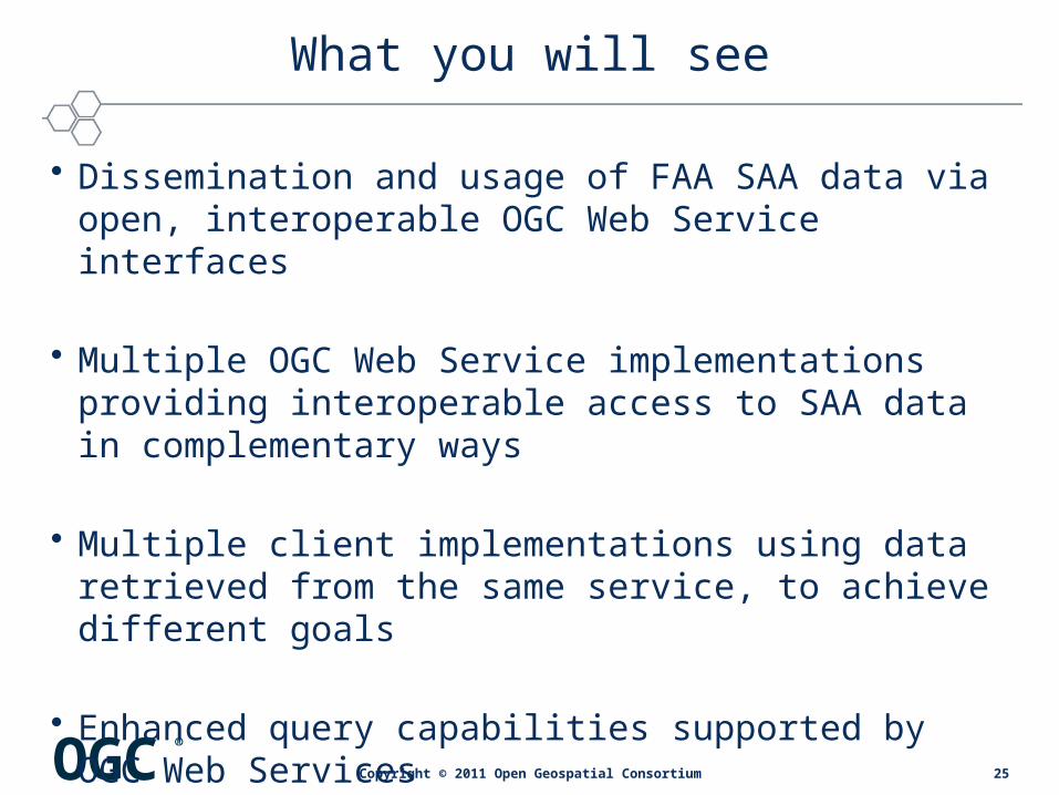
What you will see
• Dissemination and usage of FAA SAA data via open, interoperable OGC Web Service interfaces
• Multiple OGC Web Service implementations providing interoperable access to SAA data in complementary ways
• Multiple client implementations using data retrieved from the same service, to achieve different goals
• Enhanced query capabilities supported by OGC Web Services
25Copyright © 2011 Open Geospatial Consortium

OGC®
Order of Demonstrations
• Web Feature Service• Event Service• Feature Portrayal Service / Catalog Service / FPS client• Luciad client• Lufthansa Systems client
26Copyright © 2011 Open Geospatial Consortium

OGC®
Web Feature Service Demonstration
SAA Databases
SR / NASR OR / SAMS
SAA SWIM Services
OGC Web Services
Event Service
WFSRegistry/
CSWFPS/WMS
Clients
Schedule FeedSubscriber File
• Relevant components:
27Copyright © 2011 Open Geospatial Consortium

OGC®
Web Feature Service Demonstration
28Copyright © 2011 Open Geospatial Consortium
OGC®
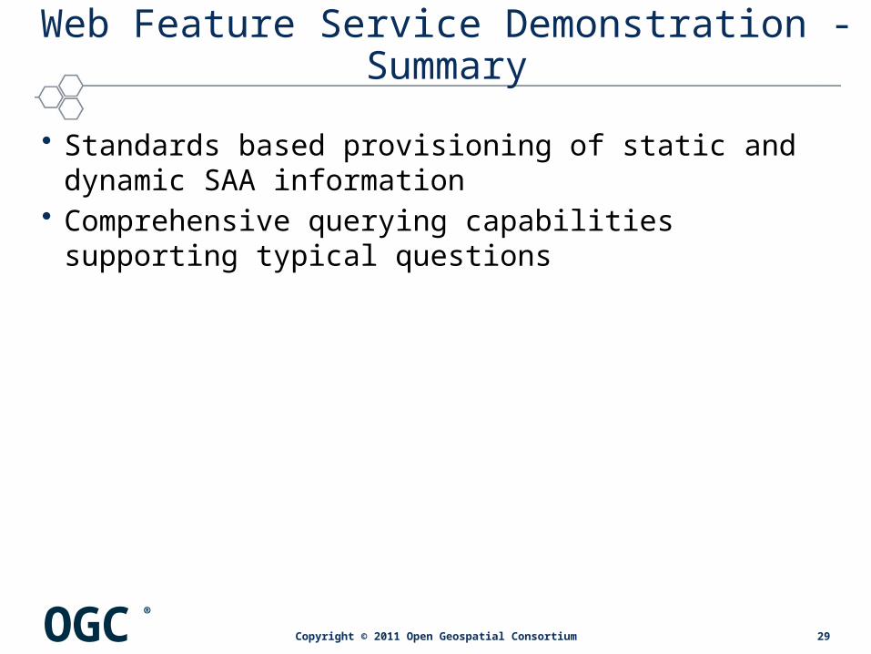
Web Feature Service Demonstration - Summary
• Standards based provisioning of static and dynamic SAA information
• Comprehensive querying capabilities supporting typical questions
29Copyright © 2011 Open Geospatial Consortium
OGC®
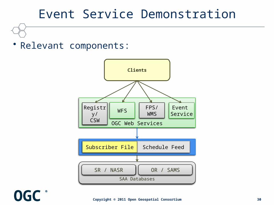
Event Service Demonstration
• Relevant components:
SAA Databases
SR / NASR OR / SAMS
SAA SWIM Services
OGC Web Services
Event Service
WFSRegistry/
CSWFPS/WMS
Clients
Schedule FeedSubscriber File
30Copyright © 2011 Open Geospatial Consortium
OGC®
Event Service Demonstration
31Copyright © 2011 Open Geospatial Consortium

OGC®
Event Service Demonstration - Summary
• Automated publication and delivery of dynamic SAA information to interested clients, based on sophisticated filter criteria
32Copyright © 2011 Open Geospatial Consortium

OGC®
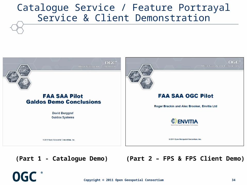
Catalogue Service / Feature Portrayal Service & Client Demonstration
SAA Databases
SR / NASR OR / SAMS
SAA SWIM Services
OGC Web Services
Event Service
WFSRegistry/
CSWFPS/WMS
Galdos/Envitia Client
Schedule FeedSubscriber File
• Relevant components:
33Copyright © 2011 Open Geospatial Consortium
OGC®
Catalogue Service / Feature Portrayal Service & Client Demonstration
34Copyright © 2011 Open Geospatial Consortium
(Part 1 - Catalogue Demo) (Part 2 – FPS & FPS Client Demo)

OGC®
Catalogue Service / Feature Portrayal Service & Client Demonstration - Summary
• Registry: standards based, flexible discovery of resources, supporting diverse metadata models
• FPS / FPS client: standards based portrayal of SAA information in light-weight client
35Copyright © 2011 Open Geospatial Consortium
OGC®
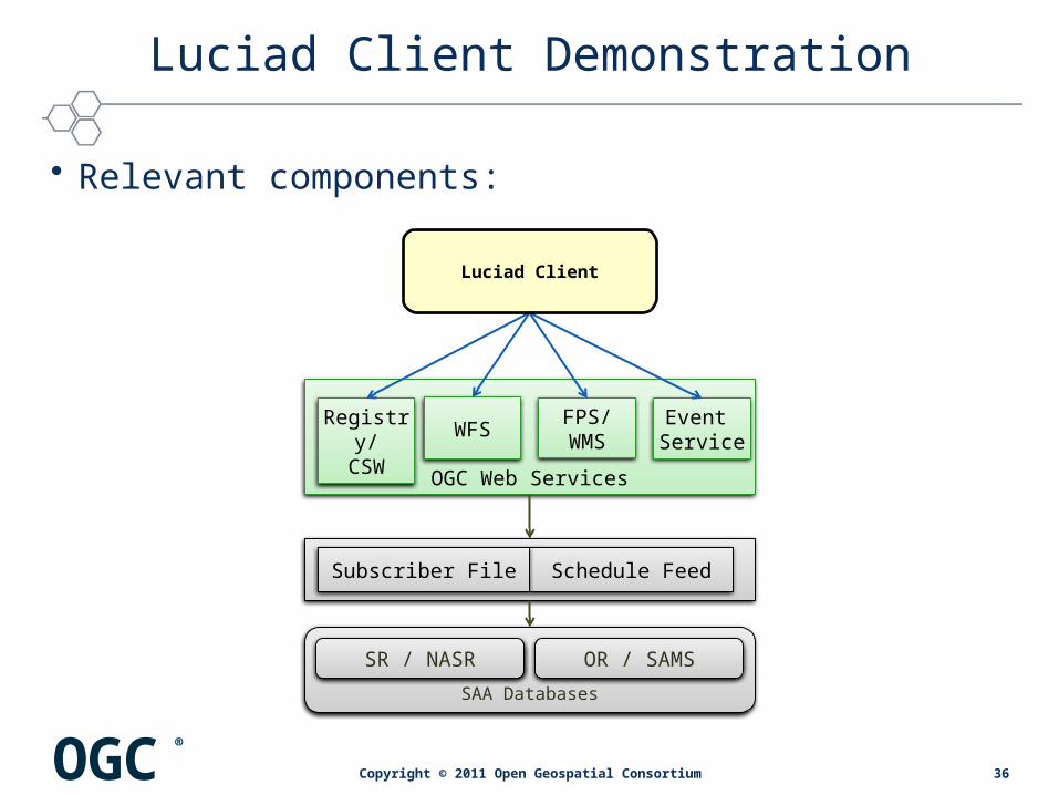
Luciad Client Demonstration
SAA Databases
SR / NASR OR / SAMS
SAA SWIM Services
OGC Web Services
Event Service
WFSRegistry/
CSWFPS/WMS
Luciad Client
Schedule FeedSubscriber File
• Relevant components:
36Copyright © 2011 Open Geospatial Consortium
OGC®
Luciad Client Demonstration
37Copyright © 2011 Open Geospatial Consortium

OGC®
Luciad Client Demonstration - Summary
• Multi-purpose, standards based client - supporting SAA information retrieval, notification and portrayal
38Copyright © 2011 Open Geospatial Consortium
OGC®
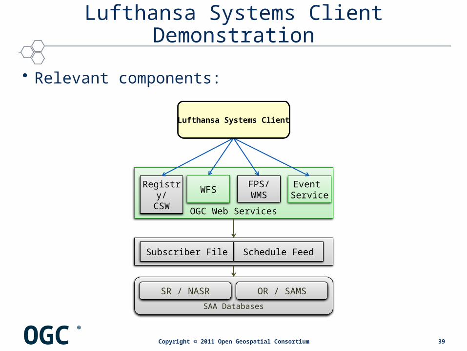
Lufthansa Systems Client Demonstration
SAA Databases
SR / NASR OR / SAMS
SAA SWIM Services
OGC Web Services
Event Service
WFSRegistry/
CSWFPS/WMS
Lufthansa Systems Client
Schedule FeedSubscriber File
• Relevant components:
39Copyright © 2011 Open Geospatial Consortium

OGC®
Lufthansa Systems Client Demonstration
40Copyright © 2011 Open Geospatial Consortium
OGC®
Lufthansa Systems Client Demonstration - Summary
• Standards based integration of SAA information in COTS electronic charting product
41Copyright © 2011 Open Geospatial Consortium
OGC®
CONCLUSION
42Copyright © 2011 Open Geospatial Consortium

OGC®
Accomplishments
• Another successful OGC Interoperability Program Initiative, despite having to work around scope and requirements changes due to SAA source data limitations– Cooperation and coordination among multi-national participants
• Academic institutions• Aeronautical information technology companies• Commercial GIS product development representatives
– Consistent and responsive contributions and support from FAA participants and representatives
– Special thanks to Johannes Echterhoff in leading this effort, in recognition of his organizational, management, and note-taking skills
43Copyright © 2011 Open Geospatial Consortium
OGC®
Accomplishments
• Implemented support for AIXM 5.1 in OGC standards based web service components
• Mapped AIXM 5.0 data into AIXM 5.1• Supported AIXM 5.1 temporality model• Supported SAA AIXM schema extension• Tested the draft Digital NOTAM Event Specification
• Implemented WFS and ES support for complex airspace geometries, aggregated airspaces, and improved filter capabilities in spatial queries
• Interfaced WFS and ES with available data sources via adapter components
• Implemented support for portrayal of AIXM 5.1 data (via WMS, FPS and Registry)
• Time-dependent map display styling
• Demonstrated the value of geospatial and temporal data fusion for the display and use of airspace activation data in realistic aviation scenarios
44Copyright © 2011 Open Geospatial Consortium

OGC®
Lessons Learned
45Copyright © 2011 Open Geospatial Consortium
• Implemented AIXM / OGC standards are mature enough for industry adoption• OGC, GML and AIXM standards clarifications• Draft standards need to be finalized (e.g. Event Service)
• Using OGC Web Services for SAA data dissemination• Integration of static and dynamic data (via WFS) enables value added
functions such as airspace proximity notification• Retrieving static and dynamic AIXM data from a single source (WFS), fine
grained retrieval of AIXM feature timeslices needs work• Support for snapshot timeslices is important for decision support scenarios• Demonstrated usefulness of time dependent, greater than 2D portrayal of
SAA information• Challenges
• Having more stable requirements and established data standards would facilitate integration efforts, especially with short-duration initiatives
• Data quality does not yet meet requirements for productive use, SAA data has to be validated for consistency before being disseminated

OGC®
Value Added
• Aviation Industry– Demonstrated value of OGC open standards compliance in facilitating cost-effective
multi-vendor tool integration– Standards-based approach makes interface implementation viable– Demonstrated support for both lightweight, browser-based client visualization
including cross-section perspective, and thick client tools with more advanced data analysis and rendering
– Implemented architecture can better address realistic flight data decision support requirements and at the same time potentially reduce the number of cases of non-compliance of airspace users
– Offers enhanced pilot situational awareness for onboard systems– Provided insight to industry on what changes are required to take advantage of AIXM
compliant data disseminated via OGC web services
• FAA– Created a single consolidated source of SAA data for dissemination using OGC-
standard web services and AIXM message formats – Beta test of AIXM-format airspace definitions and AIXM 5.1 SAA extensions– Utility of consolidating separate VFR images into single VFR chart display
46Copyright © 2011 Open Geospatial Consortium
OGC®
Future Directions
• Industry Standards– Further evolution and refinement of AIXM temporality model conventions and
guidelines to enable more practical and efficient implementations– Automate SAA business rule constraint processing (using schematron)– Use of WFS 2.0 pre-defined queries to support SAA data analysis and notifications
• AIM Systems– Explore OSGi deployment of OGC service components using a common FUSE ESB– Refinements to AIM systems and service architectures in the context of consolidated
static+dynamic AIXM feature representations– Extend architecture to support end-to-end management (including editing, adding
and approval) of SAA information in the system– Test integration of SWIM-based SAA services with OGC service components– Performance benchmarking and assessment of comparative architecture
scalabilities
47Copyright © 2011 Open Geospatial Consortium
OGC®
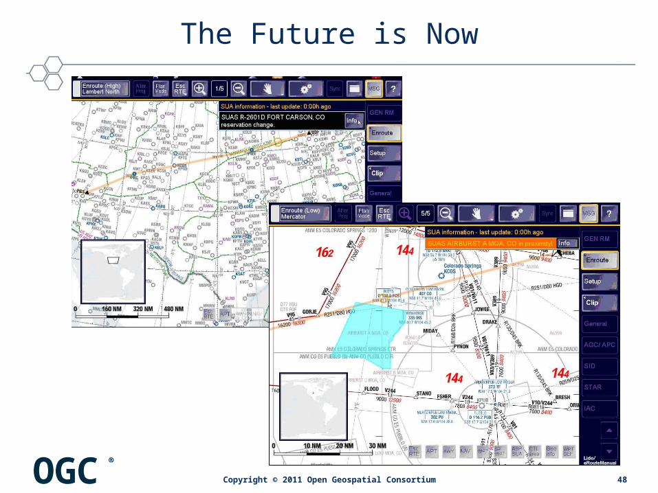
The Future is Now
48Copyright © 2011 Open Geospatial Consortium
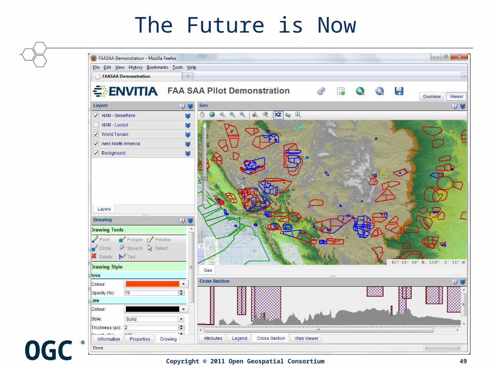
OGC®
The Future is Now
49Copyright © 2011 Open Geospatial Consortium

OGC®
The Future is Now
50Copyright © 2011 Open Geospatial Consortium

For More Information
Open Geospatial Consortium, Incwww.opengeospatial.org
SAA Pilot Demo pagehttp://www.opengeospatial.org/pub/www/saa/index.html
OGC Aviation Domain Working Grouphttp://www.opengeospatial.org/projects/groups/aviationdwg
Copyright © 2011 Open Geospatial Consortium