Embed Size (px)
Citation preview

-2 of 37-
-3 of 37-
CONTENTS 1 COMPLAINT ................................................................................................................................... 5 2 BACKGROUND .............................................................................................................................. 6
2.1 Santa Ana River Watershed .................................................................................................... 6 3 INVESTIGATION ............................................................................................................................ 8
3.1 Pre-Inspection Investigation ..................................................................................................... 8 3.1.1 Groundwater Recordations ............................................................................................... 8 3.1.2 Well Completion Reports ................................................................................................ 10 3.1.3 Information from Nestlé .................................................................................................. 10 3.1.4 Information from United States Forest Service, San Bernardino National Forest ............ 11
3.2 Geology, Hydrogeology, and Geomorphology ....................................................................... 11 3.3 Inspection Narrative ............................................................................................................... 12 3.4 Post-Inspection Investigation ................................................................................................. 14
3.4.1 License 1649 File Review ............................................................................................... 14 3.4.2 Historical Document Search ........................................................................................... 15 3.4.3 Hydrological Data and Reports ....................................................................................... 17 3.4.4 NEPA Process Update ................................................................................................... 20
4 ANALYSIS AND DISCUSSION ..................................................................................................... 20 4.1 Site Hydrogeology, Topography, and Infrastructure ............................................................... 20 4.2 Permitting Authority of the State Water Board over Springs ................................................... 21 4.3 Bases of Right ....................................................................................................................... 22
4.3.1 Pre-1914 Claim Based on David Noble Smith Claim....................................................... 22 4.3.2 Pre-1914 Right Based on Plans to Export Water for Bottling .......................................... 23 4.3.3 Water Rights Recognized in the Del Rosa Judgment ...................................................... 24 4.3.4 Pre-1914 water rights based on title reports ................................................................... 27 4.3.5 Summary of Division staff’s determinations regarding bases of right claimed ................. 28
4.4 Diversions Subject to the Permitting Authority of the State Water Board ................................ 28 4.5 Available Water in the Santa Ana River ................................................................................. 30 4.6 Evaluation of Allegations ....................................................................................................... 30
4.6.1 Allegation of operating without a valid permit (Leiski)...................................................... 30 4.6.2 Allegation of Chain of Title Issues (Frye, anonymous) .................................................... 31 4.6.3 Allegation of Unreasonable Use (Eichler) and Injury to Public Trust Resources (Loe, The
Story of Stuff Project) ...................................................................................................... 31 4.6.4 Allegation of Non-Reporting (anonymous) ...................................................................... 31 4.6.5 Allegation of Diverting Without a Valid Basis of Right (Loe, Frye, The Story of Stuff
Project) ........................................................................................................................... 32 5 CONCLUSIONS ........................................................................................................................... 32
5.1 Approximate Quantification of Unauthorized Diversions ........................................................ 33 6 RECOMMENDATIONS ................................................................................................................. 34 7 REFERENCES ............................................................................................................................. 36
-4 of 37-
ABBREVIATIONS AND ACRONYMS AF Acre-feet AFA Acre-feet per annum ASC Arrowhead Springs Company or Arrowhead Springs Corporation CASGEM California Statewide Groundwater Elevation Monitoring Program CCWC California Consolidated Water Company Del Rosa Del Rosa Mutual Water Company Division Division of Water Rights DWR Department of Water Resources Forest Service United States Forest Service Hotel Arrowhead Springs Hotel Judgment Del Rosa Judgment LADBS Los Angeles Department of Building and Safety NEPA National Environmental Policy Act Nestlé Nestlé Waters North America Notice Notice of Extraction and Diversion of Water NWNA Nestlé Waters North America OE Office of Enforcement PE Pacific Electric POD Point of Diversion PRISM Parameter-elevation Regressions on Independent Slopes Model SBVMWD San Bernardino Valley Municipal Water District SGMA Sustainable Groundwater Management Act State Water Board State Water Resources Control Board Statement Statement of Water Diversion and Use
-5 of 37-
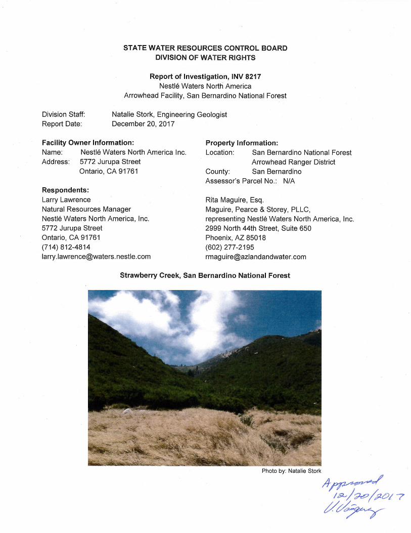
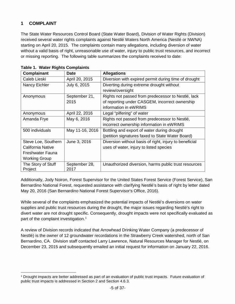
1 COMPLAINT The State Water Resources Control Board (State Water Board), Division of Water Rights (Division) received several water rights complaints against Nestlé Waters North America (Nestlé or NWNA) starting on April 20, 2015. The complaints contain many allegations, including diversion of water without a valid basis of right, unreasonable use of water, injury to public trust resources, and incorrect or missing reporting. The following table summarizes the complaints received to date: Table 1. Water Rights Complaints Complainant Date Allegations Caleb Lieski April 20, 2015 Diversion with expired permit during time of drought Nancy Eichler July 6, 2015 Diverting during extreme drought without
review/oversight Anonymous September 21,
2015 Rights not passed from predecessor to Nestlé, lack of reporting under CASGEM, incorrect ownership information in eWRIMS
Anonymous April 22, 2016 Legal “pilfering” of water Amanda Frye May 6, 2016 Rights not passed from predecessor to Nestlé,
incorrect ownership information in eWRIMS 500 individuals May 11-16, 2016 Bottling and export of water during drought
(petition signatures faxed to State Water Board) Steve Loe, Southern California Native Freshwater Fauna Working Group
June 3, 2016 Diversion without basis of right, injury to beneficial uses of water, injury to listed species
The Story of Stuff Project
September 28, 2017
Unauthorized diversion, harms public trust resources
Additionally, Jody Noiron, Forest Supervisor for the United States Forest Service (Forest Service), San Bernardino National Forest, requested assistance with clarifying Nestlé’s basis of right by letter dated May 20, 2016 (San Bernardino National Forest Supervisor's Office, 2016). While several of the complaints emphasized the potential impacts of Nestlé’s diversions on water supplies and public trust resources during the drought, the major issues regarding Nestlé’s right to divert water are not drought specific. Consequently, drought impacts were not specifically evaluated as part of the complaint investigation.1 A review of Division records indicated that Arrowhead Drinking Water Company (a predecessor of Nestlé) is the owner of 12 groundwater recordations in the Strawberry Creek watershed, north of San Bernardino, CA. Division staff contacted Larry Lawrence, Natural Resources Manager for Nestlé, on December 23, 2015 and subsequently emailed an initial request for information on January 22, 2016.
1 Drought impacts are better addressed as part of an evaluation of public trust impacts. Future evaluation of public trust impacts is addressed in Section 2 and Section 4.6.3.
-6 of 37-
2 BACKGROUND Nestlé operates a spring water diversion facility at the headwaters of Strawberry Creek in the San Bernardino National Forest. The Forest Service issued a series of Special Use Permits (SUPs) to Nestlé and predecessors starting in 1930 (Maguire, Pearce & Storey, PLLC, 2016c). The most recent SUP was issued August 2, 1978 to Arrowhead Puritas, Inc. for the purpose of “maintaining thereon water transmission lines, necessary service trails to maintain pipelines and water collection tunnels, horizontal wells, and spring boxes” (US Forest Service, 1978). The 1978 SUP was amended on June 24, 1981 adding an expiration date of August 2, 1988. In early 2015, The Desert Sun Newspaper began investigating Nestlé’s ongoing diversions under the expired SUP (James, 2015). The article and subsequent follow-up articles were re-published through several news outlets and were highly visible on social media. Several online petitions organized via MoveOn and Courage Campaign collected thousands of signatures urging the Forest Service, State, and Federal Government to end Nestlé’s diversion of water from the San Bernardino National Forest.2 As a result of the complaints and due to repeated media and private citizen inquiries, the Division determined that an investigation into the basis of right and possible public trust injuries was appropriate. On October 15, 2016, the Center for Biological Diversity, the Story of Stuff Project, and the Courage Campaign filed a complaint against the U.S. Forest Service for declaratory and injunctive relief in the US District Court, Central District of California, Eastern Division, requesting the court to issue an injunction to “prohibit operation or modification of the West Strawberry Diversion Structure unless and until a valid special use permit authorizing such action is in effect,” among other requests (Center for Biological Diversity, et al. v. US Forest Service, et al., 2015).3 On September 20, 2016, the court dismissed the plaintiffs’ action with prejudice by denying the plaintiffs Motion for Summary Judgment and granting the defendant’s Motion for Summary Judgment on the grounds that the SUP is still valid.4 The lawsuit is now on appeal with the US Court of Appeals 9th Circuit. As part of the SUP re-issuance process, the Forest Service initiated a National Environmental Policy Act (NEPA) analysis (San Bernardino National Forest, 2016). The Division submitted a comment during the public scoping period indicating that the Forest Service should require Nestlé to identify its basis of right, and that studies and plans proposed by the Forest Service should indicate if Nestlé’s diversions impact public trust resources so that Nestlé can address these impacts (State Water Board, 2016). On June 1, 2016, Division staff met with Forest Service staff to discuss the Division’s comment provided during the NEPA scoping period. 2.1 Santa Ana River Watershed Strawberry Creek, within a canyon locally known as Strawberry Canyon, is tributary to East Twin Creek, thence the Santa Ana River. The Santa Ana River is the largest stream system in Southern California and covers about 2,700 square miles (US Geological Survey, 2016b). The watershed extends from Big Bear Lake to the Pacific Ocean and from San Antonio Creek in the San Gabriel Mountains to the west to Bautista Creek and the San Jacinto River in the San Jacinto Mountains to the east. Important
2 See http://petitions.moveon.org/find/?page=1&q=nestle&state=CA, https://www.couragecampaign.org/press-releases/activists-submit-280000-comments-us-forest-service-demanding-end-nestl%C3%A9-water 3 Center For Biological Diversity v. United States Forest Service (2015 WL 5949194) 4 Center For Biological Diversity v. United States Forest Service (2016 WL 5334474)
-7 of 37-
reservoirs in the watershed include Big Bear Lake, Prado Reservoir, Lake Perris, Lake Elsinore, and Lake Matthews. Average precipitation ranges from 12 to 40 inches per year from the coastal plains to the San Bernardino Mountains (US Geological Survey, 2016b). Most of the precipitation in the San Bernardino region falls on the San Bernardino and San Gabriel Mountains, and streams issuing from the mountains supply most of the groundwater recharge to basins in the San Bernardino area (Dutcher & Garrett, 1963). Diversions of surface water and groundwater in the Santa Ana River watershed are subject to the regulatory authority of the State Water Board in five ways:
(1) Diversions from surface streams and from subterranean streams flowing through known and definite channels are subject to the permitting authority of the State Water Board, unless diverted under a valid riparian, pre-1914, or other valid basis of right;
(2) Diversions from surface streams and from subterranean streams flowing through known and definite channels under a valid riparian, pre-1914, or other basis of right must be reported annually to the State Water Board by submitting a Statement of Water Diversion and Use (Statement)5;
(3) Groundwater extractions of greater than 25 acre-feet per annum (AFA) from wells in Riverside, San Bernardino, Los Angeles, and Ventura counties are subject to the Groundwater Recordation Program;
(4) All water in the State is subject to the State Water Board’s authority to prevent the waste and unreasonable use of water;
(5) Groundwater basins within the watershed are subject to the 2014 Sustainable Groundwater Management Act (SGMA), and high and medium priority basins which do not form Groundwater Sustainability Agencies by July 1, 2017 are subject to intervention by the State Water Board.
All groundwater basins in the watershed are also subject to the California Statewide Groundwater Elevation Monitoring Program (CASGEM) administered by the Department of Water Resources (DWR), which requires groundwater elevation monitoring by local parties. Additionally, surface water and/or groundwater rights are adjudicated in the following court Judgments: Beaumont Basin, Chino Basin, Cucamonga Basin, Lytle Basin, Rialto-Colton, San Jacinto, Six Basins, and the Western San Bernardino Adjudication (includes San Bernardino, Riverside, and Colton Basins). Issuance of new permits for diversion of surface and subterranean streamflow within the Santa Ana River watershed has been limited by the State Water Board since 1964, when Decision 1194 (1964) recognized that no water is available for further appropriation from the Santa Ana River. The Santa Ana River was declared a fully appropriated stream system in Water Rights Order 98-08 (1998). The order declares that the Santa Ana River and all upstream sources are fully appropriated year-round, and that water right applications will not be accepted unless the application demonstrates that water is available (i.e. developed water, salvage water) or that use is non-consumptive. In Orders WR 2000-12 and WRO-2002-0006, the State Water Board acted on petitions to revise the Declaration of Fully Appropriated Streams, finding that specified water right applications could be processed. However, the findings are narrow, and do not alter the conclusions of Decision 1194 regarding future appropriations.
5 unless the diversion is excluded under Water Code §5101 (a) through (g).
-8 of 37-
3 INVESTIGATION The investigation included collecting and reviewing information and data from various sources. These sources, and the information and data obtained, are described below. The information and data were then analyzed as presented in Section 4. 3.1 Pre-Inspection Investigation Division staff contacted the following individuals to obtain information regarding Nestlé’s diversions in the Strawberry Creek watershed: Douglas Headrick, San Bernardino Valley Municipal Water District (SBVMWD) Larry Lawrence, Natural Resources Manager, Nestlé Robert Taylor, Forest Hydrologist, US Forest Service, San Bernardino National Forest Rita Maguire, Esq., Maguire, Pearce & Storey, PLLC, representing Nestlé Discussions with parties above are detailed in the following sections. In addition to the issues raised by the complainants, the investigation focused around two main questions: (1) is the water diverted by Nestlé within the permitting authority of the State Water Board if not diverted under a riparian or pre-1914 basis of right, and (2) does Nestlé have a valid pre-1914 water right or other valid water rights. Staff reviewed Division records, records provided by SBVMWD, records and reports provided by involved parties, county building permits, reports available online, and newspaper records. Records were reviewed to determine amounts of water diverted and used, places of use, seasons of use, year of first use, year of first appropriation, methods of diversion, and bases of right. Hydrological reports were reviewed to determine if water diverted is within the permitting authority of the State Water Board. Additionally, Division staff performed a site inspection to locate the points of diversion, methods of diversion, and discuss site hydrology with Nestlé staff and consultants and Forest Service scientists. Section 3.3 is the inspection narrative. 3.1.1 Groundwater Recordations The Water Recordation Act of 1955 required all persons who extract more than 25 acre feet of groundwater in Riverside, San Bernardino, Los Angeles, and Ventura counties to file a Notice of Extraction and Diversion of Water (Notice).6 At the beginning of the Groundwater Recordation Program, the initial Notice was required in 1957 and was to include the quantity of water taken annually for the previous 10 years (1947-1956). Annual Notices are required for subsequent years after the initial Notice. Under the Groundwater Recordation Program, failure to file an annual Notice for a given year after 1959 is equivalent to non-use for that year (Water Code §5004). Diversions of surface water must also be reported by anyone filing a Notice (Water Code §5002), but diverters are not required to specify how much of the water diverted is groundwater or surface water. For the purposes of the Groundwater Recordation Program, “ground water” is defined as “water beneath the surface of the ground whether or not flowing through known and definite channels.” (Water Code §5000, subd. (a)).
6 Persons subject to the Water Recordation Act were also required to provide information on surface water diversions in annual Notices, but information regarding extraction or diversion of groundwater or surface water from a single source of less than 10 AFA is not required.
-9 of 37-
Reporting is not required in annual Notices for diversions that are less than 10 acre-feet from a single source. In 2006, the State Water Board delegated authority to several local water agencies and water districts to collect the annual Notices and administer the recordation program. The local agency for the Strawberry Creek area is the SBVMWD. A review of Division records indicates that 12 groundwater recordations were submitted by Nestlé’s predecessors for diversions in San Bernardino County. Groundwater recordation numbers and owner’s designations for all Strawberry Creek Points of Diversion (PODs)7 are listed in Table 2. Six of the Arrowhead Drinking Water Company recordations (Spring Tunnels 2, 3, and Wells 1, 7A, 7B, and 8) were initially filed in 1957. These recordations list date “dug” from 1930 to 1950, and describe the PODs as springs. Four recordations (Wells 7 [G362857], 10, 11, and 12) were initially submitted in the 1980’s. Of the remaining two recordations, the file for the Spring 7 infiltration gallery [G360479] noted that extractions ceased in 1950, and the initial filing for Well 7-C is lost. The POD locations for the groundwater recordations are not within the Western San Bernardino adjudicated basin area or within the Upper Santa Ana Valley groundwater basin. The Upper Santa Ana Valley groundwater basin is included under the CASGEM program8 and is a High Priority Basin subject to SGMA. Since Nestlé’s PODs are not within the Upper Santa Ana Valley groundwater basin, the diversions from Nestlé’s PODs are not subject to these regulatory programs. Seven groundwater recordations located near the old Arrowhead Springs Hotel (Hotel) were submitted by the similarly named Arrowhead Water & Power, which is not affiliated with Nestlé. Six of the seven recordations are not relevant to this investigation. One recordation, G36-1811 is for the surface water diversion originally undertaken by the Del Rosa Mutual Water Company (Del Rosa), which is discussed later. As stated above, the State Water Board delegated oversight of the Groundwater Recordation Program in some areas to local agencies in 2006. While Strawberry Creek is not in the Western San Bernardino Basin Adjudication, the SBVMWD is the local oversight agency for Strawberry Creek groundwater recordations. Division staff contacted Douglas Headrick of SBVMWD on December 21, 2015. Mr. Headrick provided annual extractions reported by Nestlé and predecessors from 1947 through 2014. Annual groundwater extractions for the Arrowhead Facility ranged from 11 acre-feet (AF) in 1989 to 506 AF in 1998.9 The average annual extraction was 192 AF from 1947 through 2015. Annual extractions from each well are shown in Figure 1. For comparison, the average annual streamflow through the USGS East Twin Creek Gauge downstream of the old Arrowhead Springs Hotel was 3,681 AF per year from 1920 through 2014.10 Annual streamflow totals and spring production are shown in Figure 2. The installation with the most water extracted cumulatively from 1947 is Spring Tunnel 2 with 4,204 AF extracted from 1947 through 2015, and the installation with the least water extracted was Spring 7 (G360479) with 116 AF extracted from 1947 to 1950.
7 Documents by Nestlé since the 1950’s refer to the PODs as springs, borings, and/or wells. For this report, all PODs where a tunnel was installed at the spring are referred to as “spring tunnels” and PODs where a boring and horizontal well were installed at the spring are referred to as “wells”. The original Spring 7 installation is referred to as an infiltration gallery. The Spring 7 wells and infiltration gallery together are referred to as the Spring 7 Complex. 8 Map layers for the adjudicated basin and CASGEM basins are viewable at https://gis.water.ca.gov/app/gicima/ 9 The minimum diversion in 2004 was likely due to the Old Fire, which destroyed Nestlé’s pipelines and infrastructure in late 2003. No diversions were reported in 1989. 10 USGS gauge 1105850 (US Geological Survey, 2017). Annual flows calculated from mean daily CFS. Data were not screened by Division staff for completeness, so actual flows may have been greater.
-10 of 37-
3.1.2 Well Completion Reports Well completion reports available either from DWR11 or Nestlé12 indicate that most of the Nestlé PODs are horizontal wells completed in fractured bedrock, from 120 to 495 feet horizontally into the hillside. Well completion reports are not available for Spring Tunnels 2 and 3. Geologic logs on well completion reports submitted by Nestlé indicate that borings were installed in mostly “medium and hard [rock]” with some clayey zones or fractured zones. The estimated yield reported on the well completion reports ranged from eight to 100 gallons per minute (gpm). The annular space near the surface of each well is grouted to provide a sanitary seal, and the seals range from 66 to 167.5 feet long horizontally. Overburden (e.g. topsoil and/or loose rock) was generally less than 10 feet thick and would have been sealed off from the screened intervals. 3.1.3 Information from Nestlé Division staff spoke with Larry Lawrence of Nestlé on December 23, 2015 by phone. Mr. Lawrence described two water tunnels and the horizontal wells at the site. He said that several of the horizontal borings were modified/replaced in the 1970’s and/or 1990’s and that most water diverted today is sourced from the horizontal wells. Mr. Lawrence said that litigation in the 1930’s proved the Arrowhead water right.13 Division staff sent Mr. Lawrence a request for information via email on January 22, 2016 asking for GPS coordinates, well completion reports, reconciliation of orphan groundwater recordation numbers in Division records, and explanation of the 1930’s litigation with a copy of the court’s decision. Mr. Lawrence responded on March 11, 2016 and provided the requested information. GPS coordinates are used in Figure 3. Well construction information such as total depth is provided in Table 3. Nestlé’s attorney provided a copy of the Del Rosa Judgment (Judgment) (Del Rosa Mutual Water Company vs. Carpenter et al., 1931) decided in the San Bernardino County Superior Court. Nestlé’s attorney wrote in the response to the Division’s request for information,
NWNA [Nestlé Water North America] has the clear right to capture and use the waters in Strawberry Creek pursuant to Del Rosa for its current bottling operations. NWNA has the valid pre-1914 surface water rights of its predecessors-in-interest including the Arrowhead Springs Corporation and California Consolidated Water Company. To the extent that any water captured by NWNA could be classified as groundwater…, the specific wording of Del Rosa adjudicated the right to develop, capture, and use this water under California state law (NWNA, 2016a).
Two subsequent information requests were submitted to Nestlé’s attorney, Rita Maguire of Maguire, Pearce & Storey PLLC. On April 20, 2016, Division staff requested documentation supporting the transfer of water rights from Nestlé’s predecessors from the time of the Judgment to the present. Rita Maguire provided a chain of title on April 21. On May 4, 2016, Division staff requested clarification of the underlying bases of rights of the parties involved in the Judgment. Division staff subsequently scheduled a site inspection for June 15, 2016 and a meeting with Nestlé staff and representatives to discuss bases of right on June 16, 2016. See below, Section 3.3, for the inspection narrative.
11 Request form available at http://www.water.ca.gov/groundwater/wells/well_completion_reports.cfm 12 Three well logs provided by Nestlé’s attorney were not provided by DWR. One well log provided by DWR was not provided by Nestlé’s attorney. 13 Nestlé’s refers to its water rights as the Arrowhead Water Rights.
-11 of 37-
3.1.4 Information from United States Forest Service, San Bernardino National Forest Division staff spoke with Robert Taylor of the Forest Service on January 25, 2016 regarding the Nestlé points of diversion, basis of right, the status of the SUP, and ongoing litigation against the Forest Service. Mr. Taylor said that the PODs for springs 2 and 3 are probably small adits constructed in the 1930’s. He said that the other springs were tapped by horizontal wells without pumps. Division staff asked about the POD for the Forest Service water right adjacent to the Nestlé PODs, and Mr. Taylor said that the Forest Service visited the site in December 2015 and were unable to find the spring associated with the Forest Service water right. Mr. Taylor discussed the Judgment and said that prior to the 1920’s, water was taken from lower down on the stream, but that the adjudication allowed Nestlé’s predecessor to take water from the current location higher in the watershed. Additionally, Mr. Taylor said that the NEPA process was initiated as part of the issuance of the new SUP, but that the Forest Service is being sued. He said that Forest Service may require a comparative study to determine the impacts of Nestlé’s diversions on the Strawberry Creek watershed, where the Strawberry Creek Watershed would be compared to one or more adjacent watersheds, as part of an Environmental Impact Study. Mr. Taylor provided a copy of the Judgment via email later the same day; however, the quality of the copy was poor and some pages were not legible. 3.2 Geology, Hydrogeology, and Geomorphology Division staff reviewed geological reports with information relevant to the Strawberry Creek Watershed and surrounding San Bernardino Mountains. This included conducting a brief literature search for information on the geologic history and geomorphological development of the San Bernardino Mountains. Division staff also downloaded and reviewed PDFs and shapefiles of the San Bernardino and Santa Ana 30’ X 60’ Quadrangles (Morton & Miller, 2006) to determine bedrock geology and fault locations. Division staff reviewed the Arrowhead Tunnels Project Special Uses Permit Geo-Sciences Specialist Report (US Forest Service, 2012) for information on the hydrogeology of the region. The San Bernardino and Santa Ana quadrangles contain some of the most complex geology in the Western US (Morton & Miller, 2006). The San Bernardino Mountains are the easternmost extent of the Transverse Ranges geomorphic province. The bedrock is mostly comprised of granodiorite and quartz monzonite bedrock in several crustal blocks that have been lifted by multiple thrust fault systems (Binnie, S. A., Phillips, Summerfield, Fifield, & Spotila, 2010), including transpression (oblique slip) across the San Andreas Fault over the last two to three million years (Spotila, House, Blythe, Niemi, & Bank, 2002). Several lines of evidence suggest that the plateau surrounding Big Bear Lake, in the north-center of the range, was once contiguous with the Mojave Desert, and has been minimally reworked (Binnie, S. A., Phillips, Summerfield, Fifield, & Spotila, 2010). This differs from the southern blocks of the San Bernardino Mountains, characterized by steep valley-slope gradients and sharp drainage divides (Binnie, Phillips, Summerfield, & Fifield, 2007). Denudation rates (erosion leading to a reduction in relief as related to mountain building processes) in the southern blocks where mean slopes may exceed 30° appear to be controlled by channel incision resulting from uplift rate, rather than resulting from slope gradient (Binnie, Phillips, Summerfield, & Fifield, 2007). The rugged topography on the southern blocks does not display any pre-uplift topography (Binnie, Phillips, Summerfield, & Fifield, 2007), since it has been entirely reworked by channel incision due to uplift rates. The Geologic map of the San Bernardino and Santa Ana 30' x 60' quadrangles (Morton & Miller, 2006) indicates that the bedrock near the Nestlé wells and spring tunnels is the Mixed granitic rocks of
-12 of 37-
Silverwood Lake and the Monzogranite of City Creek. These two bedrock units are intrusive, crystalline igneous rocks. Unit descriptions within the report indicate that both bedrock units are highly weathered. The Strawberry Creek channels and some tributary channels contain surficial talus or wash deposits. Landslide deposits are mapped on the eastern branch of Strawberry Creek and in the upper reaches of adjacent creeks to the west. The geological map shows several east-west oriented fault splays in the area associated with the Devil Canyon Fault. Based on the geology of the area, groundwater in the San Bernardino Mountains near the Nestlé facilities results from infiltration of precipitation into the fractured and faulted bedrock. Open fractures typically transmit groundwater, but faults usually act as barriers to groundwater flow due to clayey fault gouge that may accumulate on fault planes, although faults can act as flow conduits in some instances. The presence of groundwater is well documented in the Arrowhead Tunnels Project Special Uses Permit Geo-sciences Specialist Report (US Forest Service, 2012). The Arrowhead East Tunnel was constructed between the City Creek and Strawberry Creek portals from 1998 to 2009 by the Metropolitan Water District as part of the Inland Feeder Project. This project required a US Forest Service SUP and the Forest Service conducted monitoring before, during, and after the construction of the steel-lined tunnel. The 2012 report, which largely focuses on hydrological impacts during tunnel construction, notes several instances of significant groundwater inflow encountered in proximity to known faults and lineaments and associated declines in groundwater heads and streamflow thousands of feet away from the tunnel in some areas. The report also notes that groundwater storage and permeability are primarily fault controlled, and that flows are dependent on interconnected fractures and faults. Generally, in the Arrowhead East Tunnel area, east-west trending faults are barriers to groundwater flow and north-south trending faults transmit flows (US Forest Service, 2012). East-west faults are reverse or thrust faults accommodating compressive forces, and north-south faults are normal faults accommodating extension (US Forest Service, 2012). The Arrowhead East Tunnel was bored through Borea Canyon and Little Sand Canyon, which are comprised of quartz monzonite (US Forest Service, 2012) identified as the Monzogranite of City Creek (Morton & Miller, 2006), which is also mapped in the vicinity of Nestlé’s PODs. The US Forest Service report noted significant groundwater inflow while boring through the areas. The report noted 400 gpm of flow into the tunnel when breaching the Borea Canyon-1 fault and subsequent decreases in well heads and surface water flows downgradient, to the extent that supplemental water was added to the surface stream to mitigate impacts. As mining progressed eastward, flow into the tunnel peaked at 600 gpm. Groundwater heads began to recover once the sealed tunnel extended past the Borea Canyon fault zone. A similar situation was encountered when mining through the Little Sand Canyon fault zone and mitigation measures were also implemented in this watershed. Surface water impacts took several years to manifest at some sites in Little Sand Canyon. The report notes that during the 5 years and 9 months from the start of work at the Strawberry Canyon Portal to completion of the east tunnel (by tying into the City Creek section), 443.8 million gallons of groundwater were intercepted by the tunnel. This amount of water is equivalent to an average of 237 AF per year. Groundwater inflows to the tunnel ceased after grouting of the annular space and installation of the final steel liner, and mitigation with supplemental water continued at some sites into 2012. (US Forest Service, 2012). 3.3 Inspection Narrative Natalie Stork and Victor Vasquez, Division staff, performed a site inspection on June 15, 2016, accompanied by Larry Lawrence and by Mike Nicholls of Haley & Aldrich, a consulting hydrogeologist
-13 of 37-
working for Nestlé. After a safety briefing, the inspection party flew to the site via helicopter chartered by Nestlé, which is the only way to access sites 10, 11, and 12 due to the steep topography and thick forest growth. While access to the other sites from Highway 18 is possible, it is not advisable due to the steep terrain and health and safety concerns. Coordinates recorded at all field sites visited during the inspection are shown in Figure 4. The inspection party began at the Spring 7 Complex (Photo 1, see Appendix A for inspection photos), which houses the wellheads for Wells 7, 7A, 7B, and 7C. Flow meter consoles were visible on the interior wall, and solar panels were installed above the complex. Division staff observed four valved pipes coming out of the rear interior wall. Mr. Lawrence and Mr. Nichols explained that the flow meter displays are off to save power, but that flow is recorded approximately once per hour and sent to a server. No pumps or other power sources were visible, and a pipeline ran down the hill from the complex (Photo 2). Other pipes protruding from the hillside were cut (Photo 2). Mr. Lawrence and Mr. Nichols said that water is conveyed without pumps or siphons, and they explained the only controls are air brakes and pressure controls. They also pointed out the fault that runs approximately through the site, and said that when the valves on these wells were turned off temporarily in the 1990’s, the old Spring 7 infiltration gallery above began flowing again, indicating that the fault acts as a groundwater barrier. They also said that the calculated expected flows do not add up to measured flow from the wells, indicating that there may be a delay between precipitation events, pressure buildup, and flow from the wells. They said that regular microparticulate analysis results always indicate “low probability” of surface water influence. The party moved immediately uphill to the Spring 7 infiltration gallery. The site was overgrown and access to the front door was not safe. Mr. Lawrence and Mr. Nichols said that the gallery was likely constructed on the spring, and the fault is mapped through the structure. The party proceeded to the meadow area below by helicopter to visit sites 10, 11, 12, and the west branch of Strawberry Creek. From the helicopter, pipelines through the forest were visible (Photo 3). The party was joined by Forest Service staff also visiting these sites today. Mr. Lawrence and Nichols pointed out the location of Wells 11 and 12 (Photo 4). A solar panel was located nearby. The wells and associated pipes are reportedly buried and there was no evidence of their location at the meadow surface. Mr. Nichols said that very little flow comes from these wells. The pipes from Wells 11 and 12 ran through the vault housing Well 10. Flow meters were visible in the vault. Downgradient of the vault, on the west side of the streambed, a pipe was protruding between boulders (Photo 5), and Mr. Lawrence and Mr. Nichols referred to this as the “old boring 11” pipe. They said this may have been the original boring 11, and that it has not been used for an indefinite period of time. Water was not flowing from the pipe and it appeared to run downhill before it was cut off. The inspection party walked along the streambed and observed streamflow in Strawberry Creek. Division staff located the seep at the toe of the meadow, which was the highest elevation streamflow observed at the time of inspection (Photo 6). Streamflow gained from seeps and springs along the streambed and flow was approximately five to 10 gpm by visual estimate at the first confluence (Photo 7) at the time of inspection. Mr. Lawrence and Mr. Nichols noted that a fault cuts across the canyon, which acts as a barrier to groundwater flow, causing groundwater to build up and seep out at the lower end of the meadow. The inspection party proceeded back to the meadow. Division staff observed a small, dry channel cut across the meadow (Photo 8) as well as the west branch of Strawberry Creek
-14 of 37-
channel along the east side of the meadow (Photo 9), also dry. The Strawberry Creek channel contained boulders (Photo 10) and vegetation. Mr. Taylor of the Forest Service said he believes the mid-meadow channel is spring fed and disconnected from the branch of Strawberry Creek along the side of the meadow. Forest Service staff also noted that the meadow is clearly a dry meadow without evidence of animal habitation such as paths, tracks, or scat. California Bay Laurel trees predominated instead of willow, and willow would provide habitat for the Willow Flycatcher. Mr. Taylor also discussed the history of the water right held by the Forest Service, A006108, and said that he has not found the water right location. The inspection party proceeded by helicopter to the third and final landing site, which provides access to Wells and Spring Tunnels 1, 1A, 2, 3, and 8. Enroute to Spring Tunnel 3, a health and safety incident occurred and Mr. Lawrence was evacuated from the site by helicopter. The inspection party decided not to proceed to Spring Tunnel 3 due to the hazard on the trail. After evaluation and mitigation of existing health and safety hazards, the inspection resumed. The inspection party visited the Spring Tunnel 2. The inside of the tunnel was lined with concrete slabs and was approximately 5.5 feet tall and five feet wide. A weir and ultrasonic water level measurement device for determining flow were visible (Photo 11). A side tunnel on the left was visible immediately behind the mount for the water level measurement device. Division staff observed a capped pipe below the weir and a second open pipe leading out of the tunnel (Photo 12). Mr. Nicolls explained that the capped pipe is used to drain the tunnel for maintenance work. Mr. Nicholls said that the back of the tunnel is not lined with concrete and water seeps through fractures exposed on the bedrock wall. He said that this tunnel is from the 1930’s. When asked about the hydrogeology of the springs in this third area, Mr. Nicholls said that the conceptual model is slightly different for this site, because there is no apparent fault barrier and the flow from Springs 1, 1A, 2, 3, and 8 is too great to be fed by the topographical watershed alone. Therefore, according to Mr. Nicholls, an interconnected fracture network may supply groundwater from outside of the topographical watershed. The inspection party walked to Well 1, which was not visible because the vault was filled in with dirt (Photo 13), but the pipe from the vault lead down towards the Well 1A/8 site (Photo 14). An abandoned pipe filled with cement protruded from the slope next to the Well 1 vault. Due to access issues, only Mr. Nichols and one Division staff member proceeded to the vault for Wells 1A and 8. Division staff observed piping from the two wells inside the vault, as well as a pipe from Well 1. Back on the helicopter pad, the inspection party discussed isotopic evidence for groundwater water flow in fractures from outside of the topographical watershed. The inspection party left the site by helicopter. On the flight out, Division staff observed the location of the Well 3 vault (Photo 15), the location of the USGS gauging station (Photo 16), and the spreading basin where all East Twin Creek water is diverted for groundwater basin recharge (Photo 17). Division staff noted alternating gaining and losing reaches of the stream, including several dry reaches between the meadow and the Arrowhead Springs property, which are commonly observed in natural stream systems in southern California. 3.4 Post-Inspection Investigation 3.4.1 License 1649 File Review Division staff reviewed available records for License 1649 (A006108) currently held by the Forest Service. The original owner was the California State Department of Public Works, and the priority of
-15 of 37-
right dates to October 31, 1928. The application was protested by the West Twin Creek Water Company in 1929 and the protest was subsequently withdrawn by the President of the water company after reviewing the results of a survey. The License allows for the diversion of 9,000 gallons per day for recreational use. Division records contain an inspection report for an inspection conducted by the Division’s predecessor agency on June 5, 1935. Measured flows were equivalent to 8,640 gallons per day at the time of inspection. This flow was “understood to be slightly under maximum yield” according to the inspection report. The original POD was a concrete spring box, and water was transported 500 feet via pipeline under gravity to a hydrant and drinking fountains along the highway, and a further 1,200 feet to a public camp ground, or a rest stop in modern terms. The water was used for car radiators and for drinking. The inspection report estimated 8,000 cars per day stopped at this rest stop. The license ownership was changed to the Forest Service in 1978, and the purpose of use was changed to fire protection and wildlife enhancement in 1985. Most of the annual reports do not quantify water diverted or used, but state that water was diverted year round. The Forest Service began reporting amounts diverted in 2007. From 2007 to 2011, reported diversions were 10.1 AF per year (face value of the license). From 2012 to 2015, reported diversions were 0 AF per year. 2013 and 2014 reports indicated 9,000 gallons per day was the maximum diversion rate for each month. 2012 and 2013 reports included an explanation that the flow was unregulated and that it is assumed that the 10.1 AF of water was “kept in the system for enhancement of the habitat”. On December 9, 2016, Jody Noiron, Forest Supervisor, provided a documentation of a site survey identifying the location and conditions at the POD for the Forest Service water right (US Forest Service, 2016). The ground at the spring site on October 19, 2016 was observed to be damp and there was no surface flow according to the survey. The US Forest Service has not provided any information indicating that they are currently diverting or using water under their water right license. Reported diversions since 2012 and comments in the 2012 and 2013 reports indicate that no water was diverted or put to beneficial use. Instream use does not require a water right, and instream use under a water right without an instream flow dedication (Water Code §1707) is considered non-use of a water right. Reported annual diversions were the exact license face value (10.1 AF) from 2007 to 2011, and there is no reliable information indicating that the spring was gauged or observed flowing since 2007. It is doubtful that diversions were reported accurately by the US Forest Service or that any diversions were ongoing. 3.4.2 Historical Document Search Division staff reviewed over 50 files sent by complainant Amada Frye via email starting on June 14, 2016. The files contained historical documents, newspaper clippings, and business documents for incorporations, mergers, and sales of Nestlé’s predecessors. Division staff reviewed documents submitted by Nestlé and conducted internet searches for historical documents and newspaper articles describing the planning and/or construction of water bottling facilities and historical production of water extracted and bottled. Figure 5 (Location Overview) and Figure 6 (Arrowhead Springs Hotel Area) contain features identified in the historical document search, including properties with water rights claimed by Nestlé, the line demarcated in the Judgment above which “any and all of the water of all springs situated or obtainable in… ‘Strawberry Creek and Canyon’” was judged as belonging to Nestlé’s predecessor, the location of
-16 of 37-
the old Arrowhead Springs Hotel (San Buenaventura Research Associates, 2005)14, the location of Indian Springs (File from Amanda Frye, 2016), and watersheds delineated using the US Geological Survey’s StreamStats program (US Geological Survey, 2016a). 3.4.2.1 Newspaper Articles Division staff searched the California Digital Newspaper Collection for articles referencing Arrowhead or California Consolidated Water Company (CCWC) facilities and identified 17 articles describing facilities such as the hotel or bottling plant. Information in the articles is used to construct the following timeline: 1909 Plan to construct a pipeline from Coldwater Canyon to the terminus of the San Bernardino
Valley Traction Company’s Arrowhead rail line. Water to be transported in tanks to Los Angeles for bottling.
1913 First shipment of water bottled at Arrowhead Springs to LA via rail for shipping. 1916 Land for first bottling facility purchased. 1917 Bottling plant completed. 1919 Deliveries resume and 20,000 gallons per day available. Water is from Indian Springs. 1926 Plan to install bottling facilities on-site at Arrowhead Springs. “Consumption this year will total
8,500,000 gallons” from Indian Springs. 1929 Merger of Arrowhead Springs, Merchants Ice and Cold Storage, and Puritas. All three
companies to be administered under California Consolidated Water Company. Arrowhead’s source of water is “Arrowhead Springs”.
A list of the articles is provided in Table 4. The only description found by Division staff for the location of Indian Springs15 was in a letter to California Consumers Company from Byron Walters dated February 14, 1929 included in a file provided by Amanda Frye:
My attention has been called to the appropriation and use by the owner company and its predecessors of that certain water right emanating from the construction and use of the tunnel situated 1047.4 feet having a bearing of North 26° 9’ West from the northeast corner of Section 11, Township 1 North, range 4 West, San Bernardino Base and Meridian and commonly known as “Indian Springs”… (File from Amanda Frye, 2016)
3.4.2.2 Building Plan Search Division staff requested records from the Los Angeles Department of Building and Safety (LADBS) on January 24, 2017 after completing a preliminary online search.16 Division staff requested building permits and plot plans from 1906 to 1935 for the address and APN of the current Nestlé botting plant at 1566 E Washington Blvd in Los Angeles. The purpose of the search was to determine if the plant capacity had expanded in the 1920’s, since an increase in diversion and use may not necessarily be covered by a pre-1914 basis of right unless it was part of the plans prior to December 14, 1914. The
14 Division staff does not have any documents indicating the location of the Arrowhead Springs Hotel prior to the 1931. The hotel was rebuilt several times after initial construction due to fires. 15 There are no groundwater recordations on file that correspond to the location of Indian Springs. The location of Indian Springs does not correspond to any other spring, POD, and/or groundwater extraction identified in this investigation. 16 http://www.ladbs.org/services/check-status/online-building-records
-17 of 37-
records provided by LADBS included records for addresses 1530-1566 E Washington Blvd, 1915-1955 S. Compton, and 1918-1940 S. Tarleton St. Building permits for new structures, or for alterations that include new additional structures, are summarized below: 1917 Foundation, Building and offices, 146’ x 113’, 2 stories
Garage 20’ x 50’, 1 story 1920 Store room 50’ x 82’, 1 story 1923 Three storage sheds 150’ x 67’, 150’ x 117’, 150’ x 119’, all 1 story 1928 Bottling plant and offices 120’ x 70’, 2 stories 1929 Alteration of boiler house new 69’ x 117’, 2 stories Alteration of bottling plant new 40’ x 107’, 1 story Shed of [illegible] 266’ x 20’, 135’ x 12’, both 1 story 3.4.2.3 Historic Resources Report The Historic Resources Report for the Arrowhead Springs Hotel (San Buenaventura Research Associates, 2005), prepared for the City of San Bernardino, contains information regarding the history of the hotel and expansion of operations. The report contains the following information:
• By the 1920s, Arrowhead Springs [presumably ASC] bottling plants had spread to Ventura, San Bernardino, Colton, Santa Barbara, San Diego and Phoenix.
• Charles G. Anthony joined the Hotel as managing director in 1917. • Beginning in February 1920, Marshall leased the Hotel to the United States Veterans Bureau.
The property was used as a rehabilitation hospital for veterans of the First World War • The property was returned to Marshall and his investors on June 30, 1924. In preparation for
reopening to the public, the owners planned a million-dollar improvement program • The Hotel owners once again announced plans for Hotel expansion in March 1929, with
construction to begin immediately. These plans had been originally developed by Charles Anthony, managing director of the company, prior to the lease of the Hotel to the Veterans’ Bureau. The expansion was to be financed by the proceeds of a merger of the bottled water division of the Arrowhead Springs Corporation with two other water companies.
3.4.3 Hydrological Data and Reports 3.4.3.1 Spring Reconnaissance Survey Division staff requested a spring reconnaissance report that was in preparation during the inspection. Rita Maguire sent the report, Stream Reconnaissance Survey of Upper Strawberry Canyon and Proposed Future Data Collection Activities (Haley & Aldrich, Inc., 2016), to Division staff on July 5, 2016. The report was prepared in response to request for data from the Forest Service as part of the NEPA scoping analysis. The reconnaissance occurred from May 31 to June 10, 2016. The report noted the following observations in the upper watershed near the Nestlé PODs:
• Four wetted reaches with continuous surface flow • One reach with discontinuous surface flow • Each reach 85 to 265 feet long
-18 of 37-
• Streamflow 1-2 gpm where present Figure 1 of the report shows the following:
• A spring and 241-foot wetted reach starting approximately 150 feet downgradient from Wells 1, 1A, and 8
• Three intermittent or continuous wetted reaches downgradient of the confluence of the channels from Spring Tunnels 2, 3, and Wells 1/1A/8 but above the meadow
• No springs or wetted reaches near the Spring 7 Complex • Rim Forest Fault near the Spring 7 Complex • Waterman Canyon Fault near Wells 10, 11, and 12 • Two springs and wetted channel near the confluence of the East and West Branches of
Strawberry Creek, immediately downgradient of the intersection of the Waterman Canyon Fault with the stream channels
• Stream is nearly continuous downstream from Waterman Canyon Fault 3.4.3.2 Hydrological Studies for FDA Compliance State Water Board staff also requested from Ms. Maguire, a copy of “1997 Results of Arrowhead Springs FDA Compliance Study” prepared by Hydrodynamics Group on December 20, 2016. On January 11, 2017, Ms. Maguire provided FDA Compliance Reports for Springs 2 and 3 (The Hydrodynamics Group, 1997b), Complex 7 (The Hydrodynamics Group, 1997a), and Complex 1 and 8 (The Hydrodynamics Group, 1998), as well as the Assessment of History and Nature of Arrowhead Springs (Dames & Moore, 1999), which supersedes all prior FDA Compliance Reports according to Ms. Maguire. On August 25, 2017, Ms. Maguire provided Division staff a letter from the FDA, dated August 21, 2017, indicating that the FDA has no objection to Nestlé’s labeling of water from Springs 1, 1A, 8, 10, 11, and 12 as “spring water” under the FDA’s standard of identity regulations, based on the current conditions as described by Nestlé.17 The 1999 report indicates that water from all of the wells (referred to as bore holes in the report) and tunnels meets the FDA and State of California requirements for labeling as “spring water”. The reports provided were commissioned by Nestlé in response to changing regulatory requirements for water labeled as “spring water”. The 1999 report states that the Spring 2 and Spring 3 tunnels were developed with the construction of “engineered collection facilities”, and therefore, “water is harvested directly from these springs”. Table 1-1 in the report lists the tunnel installation date as 1947 for the Spring 2 and 3 tunnels and 1933 for the original Spring 7 infiltration gallery. The report indicates that the Spring 7 Complex wells are directly hydraulically connected to Spring 7 based on hydraulic connection testing (i.e., turning well valves off and on and measuring spring flow). Hydraulic connection testing was inconclusive at the Spring 4 Complex (Wells 1, 1A, and 8) and the Lower Spring Complex (Wells 10, 11, and 12) according to the report. 17 The FDA’s standard of identity regulations rely on different criteria for the classification of “spring water” than the State Water Board uses to determine whether water flowing from a spring or developed water from a spring is subject to appropriation or to the permitting authority of the State Water Board. For example, the FDA’s definition of spring water may include sources of water that are hydraulic connection with a spring where water is extracted via an external source (OE, 2017b, included as Appendix B to this report). Extractions via a pumping well would not be subject to the State Water Board’s permitting authority for streams unless the well was diverting flow from a subterranean stream (OE, 2016). Therefore, the FDA’s decision is not considered further in this report.
-19 of 37-
The 1999 report notes that hydraulic connection testing at the Lower Spring Complex was inconclusive because of the relatively low flow from the wells and variable flow from the springs. The report did not include any field data or information to indicate the length of the hydraulic connection test at the Lower Springs Complex. The report also states that a one-day hydraulic connection test of the Spring 4 Complex was also inconclusive because turning the well valves off and on only produced a 1% change in flow from the spring, and the well valves were turned off and on at the same time as a known diurnal fluctuation in flow.18 There is no information indicating that the test was repeated at another time to separate out the diurnal flow changes. The report indicates that the Spring Complex 4 test also may have been inconclusive because the spring is at a lower elevation than the wells in this location, so flow from the wells may not have reduced the hydrostatic head sufficiently to produce a change in flow. The 1999 report indicates that water quality analytical data suggest that the Spring 4 Complex wells and Lower Spring Complex wells are hydraulically connected to their respective springs and that this data shows that water from these wells meets the FDA and State requirements for “spring water”. The superseded 1998 report for the Spring 4 Complex (The Hydrodynamics Group, 1998) states that Well 8 is hydraulically connected to Well 1A. Flow from Well 1A increased when Well 8 was shut off for periods of four days and seven days. Flows from Well 1A decreased to the pre-test rate over several days when Well 8 was re-opened each time. The superseded 1998 report also has a conclusion for the Spring 4 Complex, differing from the 1999 report, regarding compliance with the FDA “spring water” labeling requirements, and provides more background on spring developments in this complex. The 1998 report states:
Spring 1 and 8 appear to have been natural springs that were developed by drilling bore-holes horizontally into the mountain at the spring orifices. This was standard state of practice in the 1930s and 1950s when this was done. Later when flow at the original bore-holes declined significantly; slant holes were drilled at a lower elevation to intercept the original bore-holes. Once the slant holes were completed the original bore-holes (the original spring orifices) were plugged…. No natural orifice continues to flow as required by FDA regulations…. Further careful testing at the site may qualify Spring 4 as a natural orifice that is in hydraulic connection with the bore-holes. Our testing, while not conclusive is highly suggestive that this is the case.
The superseded 1998 report was the last report produced by The Hydrodynamics Group (superseded reports for Spring 2 and 3 tunnels and the Spring 7 Complex were produced in 1997). Dames & Moore completed subsequent compliance investigations for Nestlé and produced a final report on all of the Arrowhead springs regarding FDA compliance. The 1997 and 1998 reports are presumed to be superseded since the conclusions vary from the 1999 Dames & Moore report conclusions. 3.4.3.3 Precipitation data Division staff downloaded precipitation data for evaluation of relationships between precipitation and production from the spring tunnels and wells. Precipitation data used for analyses were retrieved from PRISM (PRISM Climate Group, Oregon State University, 2004). PRISM (Parameter-elevation Regressions on Independent Slopes Model) uses physiography to create spatial climate data sets.
18 Diurnal fluctuation presumably due to plant transpiration.
-20 of 37-
Precipitation data sets were generated using the Data Explorer web interface19 for the 4 kilometer cell containing the Arrowhead Facility spring tunnels and wells. PRISM precipitation data sets were used for analyses as described in Appendix C. 3.4.4 NEPA Process Update Division staff spoke to Robert Taylor on February 22, 2017 about the current state of the NEPA environmental review for the re-issuance of Nestlé’s SUP. Mr. Taylor indicated that public comments received during the scoping period were reviewed and the Forest Service is currently analyzing the proposed alternatives. 4 ANALYSIS AND DISCUSSION 4.1 Site Hydrogeology, Topography, and Infrastructure The hydrogeology of the upper Strawberry Creek watershed in Strawberry Canyon is similar to the hydrogeology of bedrock through which the Arrowhead East Tunnel was bored. As shown by Figure 7, the Nestlé Arrowhead diversion area is mostly comprised of quartz monzonite (monzogranite) and granitic rocks and is crossed by several east-west oriented fault branches. The PODs for Springs 1-8 are located on areas mapped as the mixed granitic rocks of Silverwood Lake and the PODs for Springs 10-12 are located on the area mapped as very young wash deposits, which overlies the Monzogranite of City Creek according to the US Geological Survey San Bernardino and Santa Ana Quadrangles (Morton & Miller, 2006). Sources of water for wells drilled in this area would similarly be groundwater stored in fractured bedrock, with more water available upgradient of the east-west trending faults observed or mapped in the area which block water from flowing downgradient. The groundwater is the result of precipitation percolating into the fractured bedrock, which comes to the surface when the water table intersects with the steep topography, resulting in springs. These springs are likely more common on the upgradient side of the east-west trending faults. As stated previously, the US Forest Service Arrowhead Tunnels Report (US Forest Service, 2012) noted that east-west trending faults are generally barriers to groundwater flow in the area. Figure 7 shows an east-west trending section of the Devil’s Canyon fault immediately downgradient of Wells 10-12, and Mike Nichols, consultant for Nestlé, pointed out the surface expression of a fault (not shown in Figure 7) running directly through the old Spring 7 infiltration gallery during the inspection. Before the installation of infrastructure such as spring tunnels and wells, the springs would have discharged flow to the land surface. The uppermost reaches of the west branch of Strawberry Creek, visited during the inspection, were extremely rugged. This rugged topography is characterized by steep slopes with frequent drainages, where precipitation runoff and/or gravity moves sediment and rock downgradient, either with streamflow, in rockfalls, or as extensive slope failures as seen on the eastern branch of Strawberry Creek (see Figure 3). Channels in this area were small, dry, and contained little sediment. The meadow near Wells 10-12 was significantly less steep and was characterized by the deposition of alluvial and colluvial material from upslope. Channels in this area were eroded into the meadow. If the original springs were allowed to flow, spring water would have flowed to adjacent drainages that would constitute watercourses. 19 http://prism.oregonstate.edu/explorer/
-21 of 37-
The spring tunnels and wells currently operated by Nestlé are constructed to tap into the interconnected fracture networks that supply water to the original springs. Spring flows are generally variable throughout the year since they are fed by precipitation that slowly percolates through the fractured bedrock, resulting in water table elevations that likely fluctuate on a seasonal basis. Higher water table elevations should result in greater flows at discharge points such as springs. Since spring tunnels and wells are designed to tap into the interconnected fracture networks, when these PODs divert more flow than what would have originally emitted from the springs, the additional water is referred to as developed water. Wells constructed away from the original spring orifice may still divert spring water due to the interconnectedness of fractures. A well located upgradient of a spring would lower the water table, decreasing the water level gradient and thereby the discharge through the spring. A well located downgradient of a spring may lower the water table and cause spring discharge to cease. However, a well that taps a set of fractures isolated from a spring due to a boundary, such as a fault, may not impact spring flow. If a well punctures an east-west groundwater barrier, such as a fault, it may divert water that would have surfaced as springflow elsewhere along the trace of the fault where it intersects a drainage or even from a spring upgradient of the fault. If significant head is built up over a spring site, a proximal well discharging at a low flow rate may not impact the spring flow noticeably. Since fracture networks cannot be directly detected, it is difficult to anticipate how a well may impact spring discharge and local water tables without detailed analysis. 4.2 Permitting Authority of the State Water Board over Springs Division staff obtained a legal opinion from the State Water Board’s Office of Enforcement (OE) regarding the State Water Board’s permitting authority over springs. Cases including Gutierrez v. Wege (1905), Cross v. Kitts (1986), and Wolfskill v. Smith (1907) establish that the water flowing from a spring into a watercourse is subject to appropriation whether it percolates through the soil or reaches the stream in a running stream, and that the water is subject to appropriation regardless of whether the water reaches the surface naturally or through an artificial boring20 (OE, 2016). The diversion of water from a spring that results in a depletion of streamflow, even if diverted using an artificial boring, is within the permitting authority of the State Water Board if appropriated after 1914 (OE, 2016). Pomona Land & Water Co. v. San Antonio Water Co. (1908) establishes that the diverter has the burden to demonstrate that diversions will not injure prior rights (OE, 2016). Several State Water Board decisions grant permits for both the natural and the developed flow of spring water from subsurface diversions such as spring boxes or tunnels.21 The Judgment states that CCWC “has entered in and upon the springs at the headwaters of said Strawberry Creek and developed the water at said Springs that would not naturally flow to plaintiffs point of diversion…”, indicating that the original diversions took flowing spring water tributary to Strawberry creek as well as developed water. As explained below, naturally flowing spring water, and developed water diverted at the headwaters of Strawberry Creek, is within the permitting authority of the State Water Board unless it is diverted under a valid riparian right, diverted under an appropriative basis of right initiated prior to 1914, or unless the water diverted is percolating groundwater that would not otherwise contribute to surface flow in a natural channel. If the diverter can (1) determine the portion of the flow that resulted from development, and (2) show that the diversion of 20 Water Code §5101(a), exempts diversions of less than 25 AF from springs that do not flow off the property in which the spring is located from the Statement Program. The Statements Program is a means to record claimed riparian and pre-1914 rights. 21 See Water Rights Decisions 681, 1022, 1149, 1209, 1263, 1325, 1352, 1363, 1451, 1494, 1595, and Water Rights Order 77-10.
-22 of 37-
this developed water does not injure senior water rights downstream,22 then the developed water is not within the permitting authority of the State Water Board (OE, 2016). Unless any information to the contrary is available, all diversions from springs that would flow to a channel are within the permitting authority of the State Water Board. In summary: 1) Developed water from a spring belongs to one of the two following categories:
a) Since the burden of proof falls to the diverter of developed water, the appropriation of developed water from a spring that contributes to flow in a natural channel is within the permitting authority of the State Water Board and presumed to be in this category unless proven otherwise;
b) Developed spring water that does NOT contribute to flow in a natural channel is presumed to be “percolating groundwater” and, absent information to the contrary, is not within the permitting authority of the State Water Board.
2) Natural spring flow that contributes to a flow in a natural channel is within the permitting authority of
the State Water Board regardless of whether: a) the water is diverted after it reaches the surface; or b) the water is diverted subsurface and depletes surface flow.
4.3 Bases of Right Information provided by Nestlé or obtained by Division staff indicates several possible bases of right for water diverted or extracted by Nestle today from Strawberry Canyon. These possible bases of right are the following:
• A pre-1914 water right claimed by Nestle based on an 1865 possessory claim by David Noble Smith, a predecessor owner of the property on which the Arrowhead Hotel was later constructed.
• A pre-1914 water right identified by Division staff based on prima facie evidence of plans to export water from Strawberry Canyon by railway to a bottling plant in Los Angeles.
• An appropriative right recognized in the Judgment. • A water right dating to prior to 1914 to water from Strawberry Canyon as identified in a title
report for the Arrowhead Springs Hotel. These bases of right are reviewed and analyzed further in the sections below. 4.3.1 Pre-1914 Claim Based on David Noble Smith Claim Nestlé claims it has a pre-1914 water right that originates from an 1865 possessory claim by David Noble Smith (Maguire, Pearce & Storey, PLLC, 2016b); however, this claim appears to be limited to riparian uses of water rather than a pre-1914 appropriation (OE, 2016). David Noble Smith was the owner of property on which the Arrowhead Springs Hotel was later constructed. According to documents provided by Nestlé to Division staff, water bottling on the Hotel property began in the late 19th century (Maguire, Pearce & Storey, PLLC, 2016a). While the Division does not have any clear information regarding the location of the sources originally bottled at the Hotel, San Buenaventura Research Associates (2005) notes there are 25 springs on the Arrowhead Springs property, which 22 i.e., by diversion of water that would otherwise surface and contribute flow further downstream
-23 of 37-
strongly suggests that the original spring sources for bottled water were on the property. The bottling of water on-site was a valid riparian use, but not an appropriative use. Water must be transported off the riparian parcel for beneficial use to establish an appropriative water right (OE, 2016). Once bottling of water at the Hotel ceased in favor of bottling off the Hotel property, the riparian use became an appropriation. Consequently, diversions of water for bottling based on riparian rights held by David Noble Smith cannot be a basis of right for Nestlé’s current off-site water bottling operations. 4.3.2 Pre-1914 Right Based on Plans to Export Water for Bottling Division staff has determined that Nestlé’s predecessor, Arrowhead Springs Company or Arrowhead Springs Corporation (ASC)23 established by Seth Marshall in 1904 (San Buenaventura Research Associates, 2005), likely established a pre-1914 water right by appropriation based on the predecessor’s plans to export water by rail for bottling in Los Angeles and subsequent progressive use and development occurring within a reasonable time and diligently pursued. Nestlé provided Division staff with a Pacific Electric (PE) document, “Local Rail Lines in the Orange Empire”, which states “In July 1912, PE began surveys which lead to extending the line a quarter-mile to the Hotel itself and made available to tank cars the Arrowhead drinking water” (sic) (Maguire, Pearce & Storey, 2016b; see page 43). This survey was likely sufficient to establish intent to appropriate an amount of water for beneficial use outside of Arrowhead Springs Hotel riparian parcel, and therefore, acquire a preliminary right to the future appropriative use of water (OE, 2016). The preliminary right would have vested upon completion of the project and application of the water to beneficial use. Furthermore, a Los Angeles Evening Herald article dated September 22, 1917 states that the Arrowhead Springs plant in Los Angeles was completed and would commence operations the following week, indicating that appropriation of water for bottling at the plant began in 1917. Since construction of a bottling plant requires significant planning, and since the Pacific Electric document indicates that surveying for the rail line began in 1912, Division staff concludes that the available information is prima facie evidence that a valid pre-1914 appropriative water right was established by ASC with a priority date of 1912. Based on the 1929 deed and 1930 agreement, CCWC obtained ASC’s pre-1914 appropriative right to water from Indian Springs. This right, established by ASC, was initially deeded to CCWC in the 1929 deed (Maguire, Pearce & Storey, 2016b, Attachment 1), then partially quitclaimed back unto ASC in the 1930 agreement (Maguire, Pearce & Storey, 2016b, Attachment 2). The quitclaimed portion of the right was for culinary and drinking purposes at the Hotel, which can be characterized as riparian uses. The 1930 deed appears to leave CCWC’s right to appropriate the water of Indian Spring intact, but clarifies that this right to “surplus” water is subordinate to ASC’s right to water for use at the Hotel. The amount of water included in the pre-1914 water right would be the amount of water put to beneficial use, and likely limited to the capacity of the Los Angeles bottling plant that had been planned prior to December 14, 1914 (OE, 2016). Nestlé has not provided any information indicating the planned capacity. However, the amount of the vested right can be inferred by evaluating historical documents. Newspaper articles and advertisements obtained during the post-inspection investigation (discussed in Section 3.4.2) indicate that Nestlé’s predecessor produced 20,000 gpd in 1919 from water originating at Indian Spring, which is equivalent to 22 AFA, and also indicate that Nestlé’s predecessor planned to
23 These names were used interchangeably in historical newspaper articles. Deeds and agreements reviewed by Division staff, as well as the Del Rosa Judgment, refer to the entity as the Arrowhead Springs Corporation. Building permits prior to 1930 generally refer to Arrowhead Springs Co.
-24 of 37-
provide 8,500,000 gallons of water from Indian Spring to customers in 1926, which is equivalent to 26 AFA. The Division has not received any information indicating these pre-1914 diversions were seasonal; therefore, since these springs likely flow year-round, it is reasonable to assume the season of diversion is year-round. Based on the description of the POD as a tunnel in historical documents (Maguire, Pearce & Storey, 2016b, Attachments 1 and 2), the 22 AFA and 26 AFA would have included developed water. The natural flow likely would have been less than these amounts. The 22 AF of water advertised in the newspaper was prior to the earliest expansion of the bottling facility in 1920. Operations in the 1920’s may be within in the scope of operations planned in 1914 or prior. However, operations after about 1929 were not likely within the scope of the original plan of progressive use and development. San Buenaventura Research Associates (2005) indicates that the 1929 expansion plans were conceived by Charles Anthony, who was hired by Nestlé's predecessor in 1917. Therefore, the pre-1914 right, based on this available historical information, is no greater than 26 AFA with a priority date of 1912. 4.3.3 Water Rights Recognized in the Del Rosa Judgment Nestle claims to have pre-1914 water rights originating from its predecessor, CCWC, which was awarded access to water from the upper reaches of the Strawberry Canyon Watershed under the Judgment (1931), a stipulated settlement agreement between private parties resulting from a judicial proceeding (OE, 2017a). Prior to the Judgment, CCWC understood that it had acquired water rights from ASC through transactions documented in three deeds and agreements from 1929, 1930 and 1931. It was CCWC’s understanding that these deeds and agreements transferred various rights and facilities from ASC to CCWC, including the rights to water from Indian Springs, and the rights to all water in Strawberry Creek belonging to ASC. The 1931 agreement was the first to clarify that Strawberry Creek water rights were transferred for water north of a specified line later incorporated in the Judgment (see Figure 5). The 1931 agreement indicates that ASC may have made “false and fraudulent representations” to CCWC and that ASC may not have actually held the water rights it transferred (Maguire, Pearce & Storey, 2016b, Attachment 3). According to the Judgment, Del Rosa appropriated all remaining water in the East Twin Creek after diversion by ASC and predecessors. The Del Rosa Water Company filed a lawsuit against ASC, CCWC, and other parties most likely due to concerns that the transfer and expansion of water rights and the diversion of water in the Strawberry Canyon Watershed injured Del Rosa’s water rights. Del Rosa’s lawsuit was resolved through the Judgment, which memorialized a settlement agreement between the parties in the lawsuit (Maguire, Pearce & Storey, PLLC, 2016b). Several parties and water diversions are described and addressed in the Judgment. Figure 8 is a diagram of water diversions in the East Twin Creek and Waterman Canyon watersheds around 1931 that the parties agreed upon as described in the Judgment. Regardless of whether ASC had rights to convey to CCWC, the Judgment recognized that CCWC would nonetheless have a right to continue diverting water from Strawberry Canyon. In accordance with the Judgment, Del Rosa and CCWC agreed that CCWC would have the right to appropriate water from Indian Springs and to develop, transport by pipeline, and take out of the watershed “any and all of the water of all springs situated or obtainable” in Strawberry Creek and Canyon and lateral canyons north of a specified line (see Figure 5) for bottling (Del Rosa Mutual Water Company vs. Carpenter et al., 1931). The Judgment recognized that CCWC had invested significant sums of money and built a business dependent on the diversion of water from the springs at the headwaters of Strawberry Creek in reliance on its initial understanding that it legally acquired water rights from ASC (Del Rosa Mutual
-25 of 37-
Water Company vs. Carpenter et al., 1931). As a result, the Judgment determined “it would be inequitable to enjoin [CCWC] from continuing to so take and use said water” (Del Rosa Mutual Water Company vs. Carpenter et al., 1931). The Judgment then ordered CCWC to pay “damages” (Del Rosa Mutual Water Company vs. Carpenter et al., 1931). Understanding the Judgment’s context is important. The Judgment was not a ruling issued by a court after a full trial with testimony and cross-examination, but a stipulated agreement and settlement between private parties (OE, 2017a). As a settlement between private parties, the parties could agree to facts that that may have proven unsupportable after cross-examination. The parties could also achieve different outcomes than otherwise may have occurred through a full judicial proceeding on the merits and a technical application of water right law (OE, 2017a). The litigation, which began in 1928, and the Judgment, which was reached in 1931, also occurred during a period of significant change in water right law in California (OE, 2017a). The impacts of Article X, section 2, were still working their way through the court system (OE, 2017a). Since the State Water Board has concurrent jurisdiction over water, the outcome of the judicial proceeding is not binding upon the State Water Board (OE, 2016). The State Water Board may arrive at a different conclusion regarding the validity of Nestlé’s predecessor’s adjudicated water right in Strawberry Canyon watershed than the conclusions of the Judgment. Division staff has determined the Judgment recognized that CCWC had a right to appropriate water. However, the Judgment’s recognition of CCWC’s right was separate from and could not supersede requirements to comply with the 1913 Water Commission Act, which established the exclusive means of appropriating water in California through a comprehensive permitted scheme (OE, 2017a). As a successor in interest to CCWC, Nestlé claims to have acquired a pre-1914 water right based on the Judgment; however, the Judgment did not carve out a right from a pre-1914 right held by Del Rosa nor ASC. CCWC believed it acquired rights from ASC through the three agreements, but CCWC could only acquire rights from ASC insofar as ASC had rights to transfer. Alternatively, had Del Rosa transferred part of its pre-1914 water right to CCWC, the right would have maintained a pre-1914 priority date. However, the Judgment does not indicate that Del Rosa transferred its rights to CCWC. Instead, it indicates that CCWC’s rights were independent of Del Rosa’s. Furthermore, the Judgment does not state that CCWC purchased Del Rosa’s right. The Judgment instead states that CCWC paid Del Rosa “damages,” although it does not specify what the damages were for. Based on information obtained by the Division, Del Rosa’s water right was not sold to CCWC and the appropriation of water from Strawberry Canyon was not initiated by CCWC until after 1914. The Division does not have any information indicating that the appropriation of water from upper Strawberry Canyon was planned prior to 1914. Therefore, CCWC should have applied for a post-1914 water right permit after the Judgment, for diversions in excess of the 26 AFA originally diverted from Indian Springs, and before proceeding with further diversions of natural spring flow and diversions of developed water that would have contributed to streamflow. Although Division staff has determined that CCWC should have applied for a water right permit for the rights recognized in the Judgment, CCWC and successors may have assumed they acquired a water right with no regulatory requirements. In fact, there were no requirements at the time of the Judgment to report surface water diversions or groundwater extractions for water rights not obtained pursuant to the Water Commission Act of 1913. As explained in Section 3.1.1, the Water Recordation Act of 1955 required initial Notices of Extraction and Diversion of Water as well as annual Notices for extractions of
-26 of 37-
groundwater. Notices additionally required information regarding surface water diversions.24 CCWC’s successor, Arrowhead and Puritas Waters, filed Notices in 1957 for extractions in the Strawberry Canyon watershed. Initial Statements became required for water rights claims in 1965; however, Statements are not required for diversions reported under Notices filed pursuant to the Water Recordation Act. It is plausible that Nestlé’s predecessors assumed they held water rights granted by the Judgment and assumed they were sufficiently complying with water rights laws and regulations by filing Notices rather than applying for water right permits. Nevertheless, any good faith prior diversion in excess of its right to not more than 26 AFA does not eliminate the requirement to divert and use water under a valid right. Since the Santa Ana River is fully appropriated, as mentioned in Section 2.1, no water is available for further appropriation from the watershed, and new water rights applications have generally not been accepted since 1964, with some exceptions. To obtain a water right permit to divert water from a fully-appropriated stream system, the water right applicant must demonstrate that water is available for appropriation. Nestlé’s Strawberry Canyon diversions were reported annually under the Groundwater Recordation Program and were likely accounted for from a basin-wide perspective at the time the Santa Ana River was declared fully appropriated. While Nestlé’s predecessor did not have a permit for the diversion of water in excess of the 26 AFA that may be claimed under a pre-1914 right, some amount of water above 26 AFA may be available for appropriation subject to the permitting authority of the State Water Board. 4.3.3.1 Nestlé’s claim to all water in Strawberry Canyon Nestlé claims the right to all of the water “obtainable in Strawberry Creek and Canyon” north of a specified line based on the Judgment; however, Nestlé and its predecessors did not divert or extract all of the obtainable water. Generally, the appropriator’s right is for the amount of water that is applied to beneficial use, not for the amount claimed, nor even for the amount diverted, if not beneficially used (OE, 2016). To claim the right to all obtainable water, including water not within the permitting authority of the State Water Board (i.e., claimed pre-1914 and percolating groundwater diversions), Nestlé’s predecessors would have had to divert all Strawberry Creek streamflow, spring water, and groundwater obtainable in the entire watershed and put this water to beneficial use. This is virtually impossible given the landslide-prone conditions in the eastern half of the watershed and the expense to install diversion facilities at all springs and seeps in the watershed. The continued existence of natural flow in Strawberry Canyon, flowing from north of the Del Rosa Line, indicates that Nestle and its predecessors did not take physical possession of all the water in the watershed. Nestlé’s predecessors were also unable to obtain the claimed right to all obtainable water because there were other appropriators in the watershed. The Judgment reserved water for several downstream appropriators on East Twin Creek. Prior to the Judgment, Application A006108 was submitted by the California Department of Public Works in 1928 for diversion of water from a spring located just above Nestlé’s Well 1. Subsequently, License 1649 was granted in 1936. There is no record of a protest submitted by Nestlé’s predecessors. Additionally, well completion reports for wells installed in Rimforest, immediately upgradient of the Spring 7 Complex and within the Strawberry Creek watershed, are available on the Geotracker Regulator site (State Water Board, 2015) which contains
24 Information regarding diversion or extraction of water from a single source of less than 10 AFA was not required.
-27 of 37-
well completion reports from DWR. These wells in Rimforest may extract groundwater that could contribute to springs in the Strawberry Creek watershed. The oldest well completion report available on Geotracker is dated 1957. 4.3.4 Pre-1914 water rights based on title reports Nestlé has indicated that its pre-1914 water right claim may also be supported by information from a title report dated September 23, 1930 (see Maguire, Pearce & Storey, 2016b). According to Nestle, the title report indicates that diversions from Strawberry Canyon for use at the Arrowhead Springs Hotel occurred prior to 1914. However, Division staff’s review of a partial copy of title report (Pioneer Title Insurance and Trust Company, 1930)25 and available patent maps (Bureau of Land Management, 2017) indicates that the “Strawberry Creek” referred to in the title report may be known today as Coldwater Creek, although this is unclear.26 Claims identified in the title report were submitted by the Arrowhead Hot Springs Hotel Company, and the 1930 title report states that the “interest of the appropriators of the water described in the water notices has descended to Arrowhead Springs Corporation… by deed from Arrowhead Springs Company…”, suggesting that ASC held pre-1914 rights originating in the claims at the time of the title report.27 While the locations of the 1887 claims are unclear, leaving open the possibility of pre-1914 appropriations for use at the Arrowhead Springs Hotel, the three deeds and agreements previously discussed in Section 4.3.2 do not appear to grant CCWC any additional pre-1914 water rights originating in Coldwater Canyon or any other part of the East Twin Creek or Waterman Canyon watersheds to CCWC. The 1929 deed (Maguire, Pearce & Storey, 2016b, Attachment 1) transferred rights from ASC to CCWC for “all subterranean waters” in Waterman, Coldwater, and Strawberry Canyons “belonging to the grantor… excluding, however, all waters of the grantor from surface streams and hot springs”. In the August 6, 1930 agreement (Maguire, Pearce & Storey, 2016b, Attachment 2), which predates the September 23, 1930 title report, the Fifth agreement states these rights to subterranean waters in Coldwater Canyon are quitclaimed back to ASC. In the September 26, 1931 agreement (Maguire, Pearce & Storey, 2016b, Attachment 3), predating the Del Rosa Judgment dated October 19, 1931, the Fifth agreement states that CCWC will pay ASC $15,000 for ASC to commence development of water in Cold Water Canyon within one year, involving the construction of “pipe lines, reservoirs, and other facilities as Arrowhead may deem advisable”. The agreement does not clarify the beneficial use for water to be diverted via this pipeline, and the Division does not have any information indicating the pipeline was constructed or that any rights were subsequently deeded to CCWC. 25 Partial copy of the title report provided to Division Staff includes six of the 32 claims listed in the Index of Enclosures. 26 Two of the claims describe “Strawberry Canon”(sic) as the “North west fork of Twin Creeks”, which would suggest Waterman Canyon, which was formerly known as West Twin Creek. Two other claims are for water “In the canon (sic) known as Cold Canon (sic) and also as Strawberry Creek” (Pioneer Title Insurance and Trust Company, 1930). These claims included in the title report date to 1887 and are historical records. Locations described can be vague, inaccurate, and difficult to determine, and these historical claims are difficult to trace through subsequent records. While the locations of these claims are difficult to determine, the location of Indian Springs is clearly defined, as quoted in Section 3.4.2.1. 27 However, this is not entirely clear. The report also states that a memorandum, filed with a 1925 deed that transferred all water rights contained in the title report, noted exceptions contained in the deed, quoting the deed: “Saving and excepting from all of the above described property all roads and highways. Also all water rights, easements, and privileges belonging to said real property or any part thereof”. The report then notes that the exception is ambiguous (Pioneer Title Insurance and Trust Company, 1930).
-28 of 37-
4.3.5 Summary of Division staff’s determinations regarding bases of right claimed Nestlé’s explanation for its bases of right for its water diversions are not clear despite Division staff’s multiple requests for clarification. Nestlé claimed several poorly defined bases of right, but none of these claims are supported by evidence provided or found by Division staff. While Nestlé claims that their rights trace back to David Noble Smith and that their rights were also adjudicated by the Judgment, Division staff finds that there is no record that any of Nestlé’s water rights claims relate back to the original possessory claim by David Noble Smith. Additionally, Division staff finds that the Judgment was a stipulated settlement that is not binding upon the State Water Board. While Division staff found that the water rights claims described by Nestlé were either invalid or do not authorize Nestlé’s existing diversions of water within the permitting authority of the State Water Board, Division staff determined that Nestlé likely has a valid basis of right not previously defined or claimed by Nestlé. Division staff found that Nestlé likely has a valid claim to a pre-1914 water right to divert up to 26 AFA based on plans for appropriation for the downtown Los Angeles bottling plant. Additionally, the Judgment did not create or prove an existing pre-1914 right to water from the upper Strawberry Creek watershed, although it recognized that Nestlé’s predecessor should be allowed to continue to divert water that it had been diverting or had planned to divert. Furthermore, Division staff nonetheless found that Nestlé’s predecessor was still required to comply with the 1913 Water Commission Act in order to lawfully appropriate water identified in the Judgment. 4.4 Diversions Subject to the Permitting Authority of the State Water Board The following paragraphs discuss how Nestlé spring tunnels and wells impact flow from the original springs in the context of water rights. Based on OE legal advice (OE, 2016), Division staff determined that a significant portion of the water diverted by Nestlé is within the permitting authority of the State Water Board. Each spring is addressed below: Spring Tunnels 2, 3, and Spring 7 Infiltration Gallery: According to Hydrodynamics Group (1997a) and Dames and Moore (1999), and according to statements made by Nestlé staff and representatives during the inspection (see Section 3.3), these springs were developed by constructing a tunnel at the original spring orifice (The Hydrodynamics Group, 1997b; Dames & Moore, 1999). There are natural channels located immediately adjacent to the springs (see Appendix D), so water that would have surfaced, prior to installation of diversion facilities, would have flowed to the channels. Since the original spring orifices were altered or destroyed during construction, the amount of natural flow cannot be determined. The Division does not have any information indicating the original spring flow or how much of the flow may be developed flow. Therefore, all of the water diverted from Springs 2, 3, and the Spring 7 infiltration gallery is within the permitting authority of the State Water Board, unless diverted under a valid pre-1914 claim, because the natural flow and developed flow would have contributed to flow in natural channels if not diverted by Nestlé. Wells 1 and 8: According to the Hydrodynamics Group (1998), these springs were developed by boring at the original spring orifices and constructing horizontal wells, then by subsequent installation of new borings and wells intercepting the original borings, and by plugging the original boring outlets. There is a natural channel located immediately adjacent to the borings, so water that would have surfaced, prior to installation of diversion facilities, would have flowed to the channel. Since the original spring orifices were altered or destroyed during construction, the amount of natural flow cannot be
-29 of 37-
determined. The Division does not have any information indicating the original spring flow or how much of the flow may be developed flow. Any developed water flowing from these springs may have otherwise surfaced downgradient through other mapped springs,28 such as Spring 4, and contributed to spring-fed surface flow in natural channels. Additionally, developed flow may have surfaced upgradient as well, as indicated by the dewatering of the spring associated with Water Right License 1649. Therefore, all of the water diverted from Wells 1 and 8 is within the permitting authority of the State Water Board, unless diverted under a valid pre-1914 claim, because the natural flow and developed flow would have contributed to flow in natural channels if not diverted by Nestlé. Well 1A: According to Dames and Moore (1999), this point of diversion was developed by constructing a horizontal well. The Division does not have information indicating whether the boring was installed at a spring orifice. The Hydrodynamics Group (1998) indicates that this well is hydraulically connected to Spring 8. Considering that (1) the spring POD for License 1649 upgradient was dewatered, (2) there are no known hydrological barriers between Well 1A and downgradient springs, and (3) this well is hydraulically connected to Well 8 – then the developed flow from this well is within the permitting authority of the State Water Board, unless diverted under a valid pre-1914 claim, because the developed flow would have contributed to flow in natural channels if not diverted by Nestlé. Wells 7, 7A, 7B, and 7C: According to the Hydrodynamics Group (1997a) and Dames and Moore (1999), these points of diversion were developed by installing wells below the original Spring 7 infiltration gallery. These horizontal wells are up to several hundred feet long and appear to be bored through the Rim-Forest Fault and completed on the upgradient side of the Rim Forest Fault (The Hydrodynamics Group,1997a, Plate 2), which likely acts as a barrier to flow. According to The Hydrodynamics Group (1997a) and according to statements made by Nestlé staff and representatives during the inspection (see Section 3.3), when the wells are allowed to flow, surface flow from the Spring 7 infiltration gallery ceases. Therefore, some portion of the water diverted from these wells is flow that would have contributed to flow in natural channels. Based on the extremely limited data available to the Division and precipitation amounts obtained from the PRISM model (see Section 3.4.3), 52% of the water diverted on an annual basis from these wells may be developed water (Appendix C). It is unknown if this developed water would have surfaced elsewhere in the watershed due to the fault barrier. The Division does not have any evidence of any upgradient dewatered springs at this time. Based on Google Earth imagery, the Rim-Forest Fault appears to intersect a well-defined drainage approximately 460 feet west of the well site, but the Division does not have any evidence of a spring in this location. Therefore, at least approximately 48% of the water diverted on an annual basis from the Spring 7 Complex wells is within the permitting authority of the State Water Board, unless diverted under a valid pre-1914 claim, because this water would have contributed to flow in natural channels if not diverted by Nestlé. The remaining 52% of the water diverted may not be within the permitting authority of the State Water Board based on the limited information available to the Division at this time, because it may be developed flow that may not contribute to flow in channels elsewhere in the watershed.29 This percentage should be refined with further data collection and analysis.
28 Mapped in (Haley & Aldrich, Inc., 2016) 29 Developed flow that may not contribute to flow in channels elsewhere in the watershed due to a fault barrier and lack of significant upgradient springs, if not diverted via wells, may remain the in the aquifer and contribute to higher groundwater elevations. Once groundwater elevations are high enough, this could preclude infiltration of precipitation to groundwater and result in increased sheetflow; however, sheetflow is not subject to the permitting authority of the State Water Board. While sheetflow could reach natural channels, the relationship between groundwater and channelized flow in this case is indirect.
-30 of 37-
Wells 10, 11, 12: According to Dames and Moore (1999), these points of diversion were developed by installing wells near springs, but not at spring orifices. These horizontal wells are up to several hundred feet long and are located entirely upgradient of the Waterman Canyon Fault, which likely acts as a hydrological barrier preventing subsurface flow downgradient. The geology and topography of the site indicates that spring flow would contribute to streamflow either by overland flow to the nearby stream or by percolation and subsurface flow to the stream. Any spring flow that infiltrates into the meadow would flow downgradient and surface at the toe of the meadow where perennial Strawberry Creek begins. Dames & Moore (1999) indicates that there is no known change in springflow when the well valves are opened. However, the report did not state the length of time the springs were tested and field data from these measurements were not included in the report appendices. The study design may not have been appropriate for determining impacts over time and impacts to other springs in the area. Additionally, the wells may be diverting water that would otherwise flow below ground surface from the fractured bedrock to meadow alluvium/colluvium, and then discharge to streamflow via springs at the toe of the meadow. The observed spring at the toe of the meadow was approximately 70 feet downgradient from the Well 10 vault. Based on the hydrology of the site and reported flow from the springs, diverted flow may be entirely developed water, and it is unknown what portion of the developed water may contribute to streamflow. At this time, the Division does not have any evidence that diversions from wells 10, 11, and 12 impact other springs or streamflow. Unless additional information indicates otherwise, the water from wells 10, 11, and 12 does not appear to be within the permitting authority of the State Water Board. This evaluation should be reviewed and possibly revised after further data collection and analysis, including evaluation of impacts on spring flow at the toe of the meadow. 4.5 Available Water in the Santa Ana River While most of the water diverted by Nestlé in Strawberry Canyon lacks a basis of right, Nestlé may be able to apply for and receive a post-1914 appropriative water right for the water diverted by Nestlé’s predecessors up to the time of the 1964 fully-appropriated stream determination in Decision 1194 (1964). The maximum diverted by Nestlé’s predecessors, prior to 1964, was 257 AF in 1952, including the 26 AFA that may be claimed under a pre-1914 basis of right. Nestlé’s would have to seek an exemption from the Declaration of Fully Appropriated Streams, similar to Orders WR 2000-12 and WRO-2002-0006. 4.6 Evaluation of Allegations 4.6.1 Allegation of operating without a valid permit (Leiski) The alleged invalid permit was the SUP issued by the US Forest Service in 1976, over which the State Water Board has no jurisdiction. The court decided in the case Center for Biological Diversity, et al. v. US Forest Service, et al., 2015 that the 1976 US Forest Service SUP is valid until the US Forest Service issues a new SUP. The case is on appeal.
-31 of 37-
4.6.2 Allegation of Chain of Title Issues (Frye, anonymous) Two complainants (Frye, anonymous) suggested that the water right was not passed successfully from CCWC to Nestlé, specifically focusing on transfers from 1969 on. OE counsel reviewed the chain of title provided by Nestlé and indicated that the water rights held by ASC likely passed to Nestlé. The chain of title shows a continuous chain of owners from the Arrowhead Springs Corporation to Nestlé. These Arrowhead water rights include a pre-1914 claim that may be valid for beneficial use of up to 26 AFA. Documents provided by Amanda Frye, also reviewed by OE counsel, did not include any documents indicating that the water rights were lost. 4.6.3 Allegation of Unreasonable Use (Eichler) and Injury to Public Trust Resources (Loe, The
Story of Stuff Project) One complainant (Eichler) and hundreds of signers of a petition submitted to the State Water Board suggest that bottling water in a time of drought is an unreasonable use of water. Bottling water is an industrial use of water, which is a beneficial use as described under the California Code of Regulations.30 However, not every beneficial use is considered equal. Water Code §106 states that domestic use is the “highest use of water” and that irrigation is the next highest use. As long as Nestlé’s use of water does not injure diverters whose beneficial use is for domestic purposes or irrigation, then the industrial use is considered by the Water Code to be in the public interest. Based on a search of the State Water Board’s eWRIMS database,31 the nearest downstream water rights, other than Del Rosa’s water right, are two post-1914 appropriative water right licenses, License 6378 and License 6403 (A008899 and A008900), held by the Orange County Water District at the Prado Dam, which is a flood control and water conservation project constructed by the Army Corps of Engineers (US Army Corps of Engineers, 2013). These water right licenses have 1937 priority dates. Based on the distance between the diversions (over 30 miles straight-line and much further by stream miles) and no claim of injury by Orange County, Nestlé’s diversions do not likely have an impact on the beneficial use of water diverted at the Prado Dam. Nestlé’s use of water could also be unreasonable if it injures public trust resources, such as instream habitat for certain species, in such a way that it outweighs the beneficial use. Two complainants (Loe, The Story of Stuff Project) allege Nestlé’s diversions injure public trust resources. At this time, the Forest Service is undertaking an environmental impact review pursuant to NEPA, and the Forest Service and Nestlé are developing an adaptive management plan. The Forest Service is the appropriate agency to address the environmental impacts in this case. Should information become available indicating that Nestlé’s diversions are injuring environmental resources that will not be mitigated, the Division may further investigate the possible injury under its public trust authority and determine if other appropriate remedies are necessary. 4.6.4 Allegation of Non-Reporting (anonymous) An anonymous complainant alleged that Nestlé is not reporting to “mandated monitoring programs such as CASGEM.” However, Nestlé has reported annual diversions under the Groundwater Recordation Program, and this is the only required reporting to the Division at this time. Nestlé and predecessors
30 Cal.Code Regs. Tit. 23 § 665 31 http://www.waterboards.ca.gov/waterrights/water_issues/programs/ewrims/
-32 of 37-
have been reporting under the Groundwater Recordation Program since 1957 to either the State Water Board or to the designated local oversight agency, Western Municipal Water District and/or the SBVMWD. Diversion data going back to 1947 is available from SBVMWD upon request. The Nestlé PODs are outside of the local adjudicated basin and the local groundwater basin included under the CASGEM and Sustainable Groundwater Management Act (SGMA) programs. While Nestlé’s groundwater recordation reporting is up to date, some reporting issues remain. Nestlé’s diversions are reported under the ownership name “Arrowhead Drinking Water Company”, which is not the current name of the POD owner. Under existing code32 and regulations,33 as long as Nestlé is diverting and reporting at least 25 AFA of groundwater not within the permitting authority of the State Water Board, any surface water diversions authorized under other valid water rights, such as a riparian or pre-1914 claim, may be reported under the Groundwater Recordation Program. 4.6.5 Allegation of Diverting Without a Valid Basis of Right (Loe, Frye, The Story of Stuff
Project) Three complainants (Loe, Frye, and The Story of Stuff Project) allege that Nestlé is diverting water without a valid basis of right. Nestlé likely has a pre-1914 right for an amount no greater than 26 AFA, and Nestlé may hold appropriative groundwater rights not within the permitting authority of the State Water Board for developed groundwater. Diversion of any water within the permitting authority of the State Water Board without a valid water right permit or license is unauthorized. Nestlé has likely diverted, and continued to divert, water without a valid basis of right based on determinations stated in Section 4.4. Frye alleges that any pre-1914 rights only attach to diversions at the site of the possessory claim by David Noble Smith in 1865. However, this claim is not applicable to any pre-1914 water right, identified by Division staff, and PODs can be changed to other sites within a stream’s respective watershed for diversions under a pre-1914 water right.34 5 CONCLUSIONS Based on review of available information, Division staff has concluded the following:
• Nestlé’s claim to a pre-1914 water right that originates from an 1865 possessory claim by David Noble Smith is limited to riparian uses and is not valid for Nestlé’s current appropriative diversion and use of water from the San Bernardino National Forest;
• Nestlé could claim up to 26 AFA for appropriative diversions from Indian Springs, including developed water, under a pre-1914 basis of right identified by Division staff based on 1912 plans to bottle water in Los Angeles;
• Nestlé likely has an appropriative groundwater claim to an unknown amount of developed percolating groundwater that would not have contributed to surface flow in a natural channel elsewhere in the watershed;
32 Water Code § 5002 33 Cal.Code Regs. Tit. 23 § 930 34 Water Code § 1706
-33 of 37-
• While Nestlé may be able to claim a valid basis of right to some water in Strawberry Canyon, a significant portion of the water currently diverted by Nestlé appears to be diverted without a valid basis of right;
• The Del Rosa Judgment recognized that Nestlé’s predecessors had a right to the diversion and use of water from Strawberry Canyon as against a prior water right claimant; The diversion and use of water under the right recognized in the Del Rosa Judgment would
have required a permit insofar as it was not based on an appropriation initiated before 1914 or diverted under a claim for groundwater that is not within the State Water Board’s permitting authority;
Nestlé may be able to seek an exemption from the Declaration of Fully Appropriated Streams (see, e.g., Orders WR 2000-12 and WRO-2002-0006);
• At this time, there is insufficient information to determine if Nestlé’s diversion injures public trust resources in such a way that it outweighs the beneficial use.
5.1 Approximate Quantification of Unauthorized Diversions Table 5 below summarizes approximately how much was diverted under each basis of right in 1998, which was the year in which maximum annual diversions occurred:
Nestlé likely has a pre-1914 appropriative right for an amount up to 26 AFA, including developed water. Some amount of the water being diverted by Nestlé from the Strawberry Canyon springs and wells is developed water that would have surfaced elsewhere in the watershed and contributed to surface flow. This developed water is within the permitting authority of the State Water Board, and diversion is therefore unauthorized unless diverted under a pre-1914 claim or other valid basis of right. Some amount of the water diverted from the Strawberry Canyon springs and wells may be developed water that would not otherwise contribute to streamflow, and appropriation of this groundwater is not within the permitting authority of the State Water Board. Neither portion of developed water is fully quantified at this time. However, based on limited information, up to approximately 52% of water diverted from the Spring 7 wells (Wells 7-7C), on an annual basis, and up to all of the water from the Lower Springs Complex wells (Wells 10, 11, and 12) is groundwater that may not be within the permitting authority of the State Water Board. The amount Nestlé could have diverted in 1998 under a pre-1914 claim and as groundwater from the Spring 7 wells and Lower Springs Complex totals up to an approximate maximum of 152 AFA, but this amount could be much less if groundwater not within the permitting authority of the State Water Board was overestimated. Detailed hydrological studies showing how diversions impact streamflow are needed to determine the actual amount of developed water that would or would not surface elsewhere in the watershed.
Table 5. Basis of Right and Amounts Diverted for 1998 BASIS OF RIGHT AMOUNT 1998 AMOUNT Pre-1914 Up to 26 AFA Up to 26 AFA Groundwater Up to approximately 52% of Wells 7-7C
production; Up to 100% of Wells 10, 11, 12 production
Up to 126 AF
Unauthorized All other diversions 356 AF or greater Total 508 AF
-34 of 37-
6 RECOMMENDATIONS Division staff recommends that Nestlé immediately cease any unauthorized diversions. Additionally, Division staff recommends Nestlé take the following actions:
• Within 30 days, for any diversion not subject to a notice filed under Part 5 of the Water Code, submit to the Division an initial Statement pursuant to Water Code § 5101 for:
(1) unauthorized diversions; and (2) diversions under any valid pre-1914 claim of right
• A Supplemental Statement must be filed annually for any diversion not subject to a notice filed under Part 5 of Division 2 of the Water Code (i.e., the Groundwater Recordation Program);
• Update ownership of Groundwater Recordations. If annual diversions of groundwater not within the permitting authority of the State Water Board from Strawberry Canyon fall below 25 AFA, reporting under the Groundwater Recordation Program for diversions of groundwater is no longer required.
• Within 60 days, submit an interim compliance plan for Division review and approval to ensure that diversions do not exceed those allowable under any valid bases of right;
• Within 90 days, submit an investigation and monitoring plan for Division review and approval. The investigation and monitoring plan should include:
(1) Investigation and monitoring to determine the portion of developed water, if any, that is not tributary to flow in any natural channel and can therefore be diverted without authorization from the State Water Board; and
(2) Monitoring of diurnal, seasonal, and other flow variations using industry standard equipment and methods for measuring flow;
• Within 18 months, submit a final report and compliance plan for Division review and approval, The final report should:
(1) Determine the amount of water to be diverted that will not be within the permitting authority of the State Water Board;
(2) Include a detailed explanation of methods; (3) Include a model for determining how diversions impact or do not impact surface flows,
and provide a sufficiently detailed description of the model to allow Division staff to evaluate the model; and
(4) Include a final compliance plan. • For its current operations in the SBNF, if Nestlé wishes to divert water subject to the permitting
authority of the State Water Board, i.e., in excess of the 26 AFA for which it likely has a valid pre-1914 claim, it must apply for and receive a water right permit before diverting or using water. While the Santa Ana River is a fully appropriated stream system, Nestlé may seek an exception and choose to apply for a post-1914 water right permit. The application will not be accepted unless Nestlé can demonstrate that there is water available for appropriation.
Other Division staff recommendations:
• Take no further action on the allegations of unreasonable use and injury to public trust resources at this time. If future hydrologic and riparian studies indicate that Nestlé’s diversion of water injures public trust resources in a way that cannot be mitigated by implementation of the
-35 of 37-
adaptive management plan in development as part of the US Forest Service Special Use Permit process, the Division should revisit this issue.
-36 of 37-
7 REFERENCES Binnie, S. A., Phillips, W. M., Summerfield, M. A., & Fifield, L. K. (2007). Tectonic uplift, threshold
hillslopes and denudation rates in a developing mountain range. Geology, 35, 743-746. Binnie, S. A., Phillips, W. M., Summerfield, M. A., Fifield, L. K., & Spotila, J. A. (2010). Tectonic and
climatic controls of denudation rates in active orogens: The San Bernardino Mountains, California. Geomorphology, 118(3), 249-261.
Bureau of Land Management. (2017). Survey Plats and Field Notes Search. Official Federal Land Records Site. See survey plat for T1N R4W SBB&M dated 8/30/1878 and others. https://glorecords.blm.gov/.
Center for Biological Diversity, et al. v. US Forest Service, et al., 5:15-cv-2098 (US District Court for the Central District of California, Eastern Division October 13, 2015).
Cross v. Kitts, 69 Cal. 217, 222 (1986). Dames & Moore. (1999). Assessment of History and Nature of Arrowhead Springs, San Bernardino
Mountains. Decision 1194. (1964). In the Matter of Application 11036 of Santa Ana Valley Irrigation Company and
Application 11037 of Orange County Water District to Appropriate from Santa Ana River and Chino Creek in Orange, Riverside, and San Bernardino Counties. State Water Resources Control Board. Oct 29, 1964.
Del Rosa Mutual Water Company vs. Carpenter et al., 31798 (Superior Court of California, County of San Bernardino 1931).
Dutcher, L. C., & Garrett, A. A. (1963). Geologic and Hydrologic Features of the San Bernardino Area. Water Supply Paper 1419.
File from Amanda Frye. (2016). Letter dated Feb 14, 1929 to California Consumers Company, California Consolidated Water Company from Byron Walters. "Doc Sep 17 2015 1115.pdf" emailed to Victor Vasquez, Division staff, on Dec 22, 2016. See pp. 7-8.
Gutierrez v. Wege, 145 Cal. 730, 734 (1905). Haley & Aldrich, Inc. (2016). Stream Reconnaissance Survey of Upper Strawberry Canyon and
Proposed Future Data Collection Activities. James, I. (2015). Bottling Water Without Scrutiny. Retrieved May 4, 2016, from The Desert Sun:
http://www.desertsun.com/story/news/2015/03/05/bottling-water-california-drought/24389417/ Maguire, Pearce & Storey, PLLC. (2016a). Chain of Title for Arrowhead Water Rights and SUP
[Transmittal to Natalie Stork, Division staff]. April 21, 2016. Maguire, Pearce & Storey, PLLC. (2016b). NWNA Response to Arrowhead Water Rights Inquiry
[Memorandum to Natalie Stork, Division staff]. July 11, 2016. Maguire, Pearce & Storey, PLLC. (2016c). Re: Transmittal of As-Built Drawings with Respect to SBNF
Special Use Permit #7285 and related Operations and Maintenance Information; Request for Exemption from the California Public Records Act [Transmittal to Ken Petruzzelli, OE staff counsel]. July 21, 2016.
Morton, D. M., & Miller, F. K. (2006). Geologic map of the San Bernardino and Santa Ana 30' x 60' quadrangles, California. USGS, Open-File Report 2006-1217.
NWNA. (2016a). RE: Request for information directed to Nestlé Waters North America Inc. Strawberry Canyon, San Bernardino, CA [Letter to Natalie Stork, Division staff]. March 11, 2016.
OE. (2016). Nestlé Waters North America Water Rights [Memorandum to Division staff]. November 17, 2016.
OE. (2017a). Nestlé Water North America prescriptive rights [Memorandum to Division staff]. May 1, 2017.
-37 of 37-
OE. (2017b). Nestlé Waters North America Report of Investigation [Memorandum to Division staff]. September 22, 2017.
Pioneer Title Insurance and Trust Company. (1930). [Letter and attachments addressed to O'Melveny, Tuller & Meyers, Attorneys]. Provided by Nestlé at June 16, 2016 meeting with Division staff. Letter dated September 23, 1930.
Pomona Land & Water Co. v. San Antonio Water Co., 152 Cal. 618 (1908). PRISM Climate Group, Oregon State University. (2004). Data Explorer: Time Series Values for
Individual Locations. Retrieved from http://prism.oregonstate.edu April 17, 2017. R Core Team. (2016). R: A language and environment for statistical computing. Vienna, Austria: R
Foundation for Statistical Computing. URL https://www.R-project.org/. San Bernardino National Forest. (2016). Letter to Interested Agencies, Local Governments, Tribes, and
Public. Arrowhead Ranger District: March 18, 2016. San Bernardino National Forest Supervisor's Office. (2016). [Letter to Victor Vasquez, Division staff].
May 20, 2016. San Buenaventura Research Associates. (2005). Historic Resources Report, Arrowhead Springs Hotel,
San Bernardino, CA. Spotila, J. A., House, M. A., Blythe, A. E., Niemi, N. A., & Bank, G. C. (2002). Controls on the erosion
and geomorphic evolution of the San Bernardino and San Gabriel Mountains, Southern California. Geological Society of America Special Papers, 365, 205-230.
State Water Board. (2015). Retrieved from GeoTracker: https://geotracker.waterboards.ca.gov/regulators/
State Water Board. (2016). Public Comment/Objection Reading Room. Retrieved May 5, 2016, from Nestlé Waters North America Inc Special Use Permit: https://cara.ecosystem-management.org/Public/DownloadCommentFile?dmdId=FSPLT3_3036544&project=48530
The Hydrodynamics Group. (1997a). FDA Compliance Report: Arrowhead Spring Complex No. 7, San Bernardino National Forest.
The Hydrodynamics Group. (1997b). FDA Compliance Report: Arrowhead Springs No.'s 2 and 3, San Bernardino National Forest.
The Hydrodynamics Group. (1998). Investigation of the Arrowhead Complex 1 & 8 for FDA Compliance.
US Army Corps of Engineers. (2013). Prado Dam. Retrieved from http://natasha.spl.usace.army.mil/resreg/htdocs/prdo_2.html
US Forest Service. (1978). Special Use Permit issued to Arrowhead Puritas Inc. issued August 2, 1978, amended June 24, 1981.
US Forest Service. (2012). Arrowhead Tunnels Project Special Uses Permit Geo-Sciences Specialist Report.
US Forest Service. (2016). Memo to File: Documentation of Site Survey of Water Right A6108. US Geological Survey. (2016a). StreamStats. Retrieved July 7, 2016, from
https://streamstatsags.cr.usgs.gov/streamstats/ US Geological Survey. (2016b). Santa Ana Basin. Retrieved April 10, 2017, from California Water
Science Center: http://ca.water.usgs.gov /sana_nawqa/index.html US Geological Survey. (2017). USGS 11058500 E TWIN C NR ARROWHEAD SPRINGS CA.
Retrieved June 20, 2016, from National Water Information System: Web Interface: https://waterdata.usgs.gov/ca/nwis/uv?site_no=11058500
Water Rights Order 98-08. (1998). Order Revising Declaration of Fully Appropriated Stream Systems. State Water Resources Control Board. Nov 19, 1998.
Wolfskill v. Smith, 5 Cal.App. 175, 181 (1907).