Embed Size (px)
Citation preview
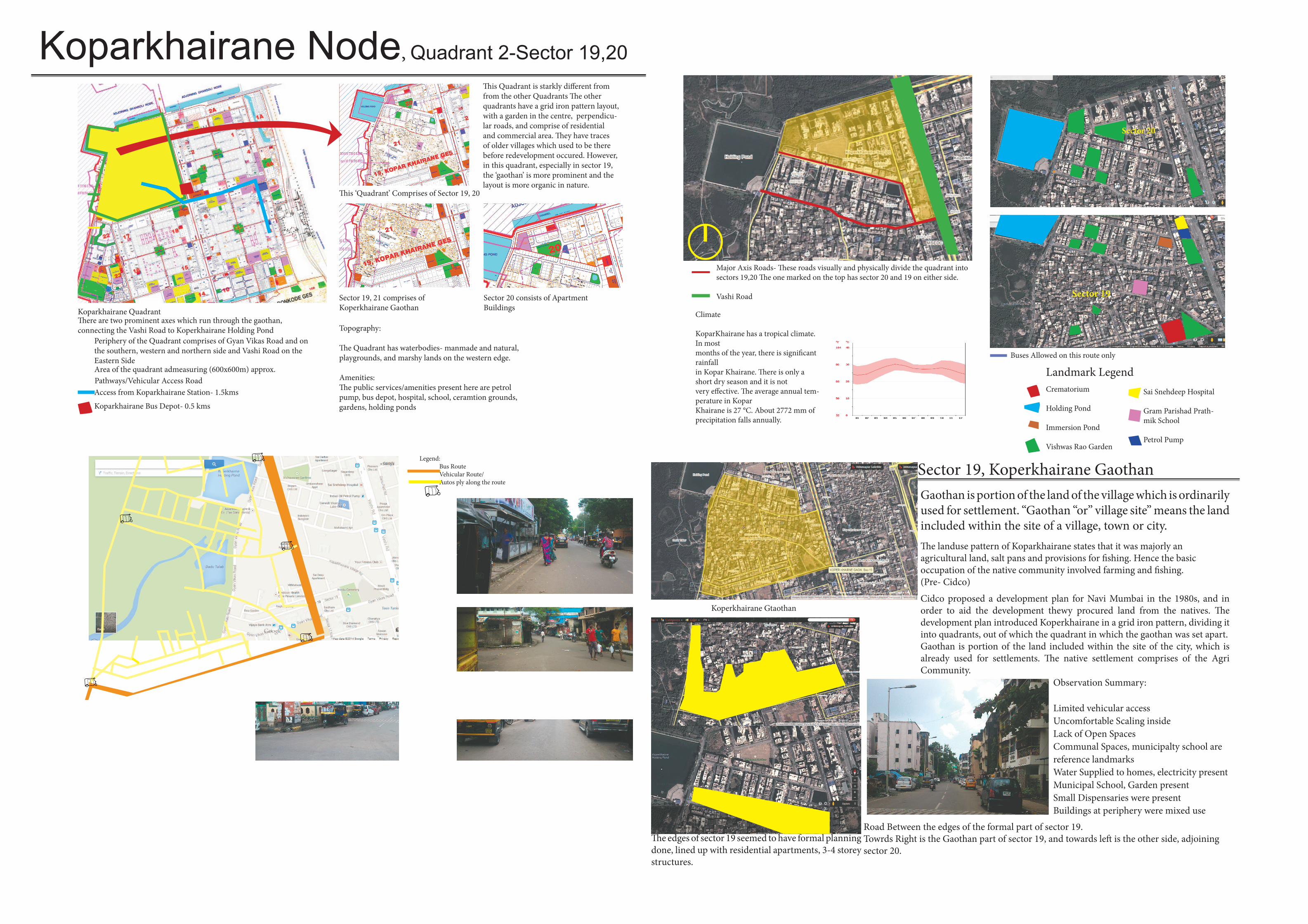
Koparkhairane Quadrant
This ‘Quadrant’ Comprises of Sector 19, 20
Koparkhairane Node, Quadrant 2-Sector 19,20
Sector 19, 21 comprises of Koperkhairane Gaothan
Sector 20 consists of Apartment Buildings
This Quadrant is starkly different from from the other Quadrants The other quadrants have a grid iron pattern layout, with a garden in the centre, perpendicu-lar roads, and comprise of residential and commercial area. They have traces of older villages which used to be there before redevelopment occured. However, in this quadrant, especially in sector 19, the ‘gaothan’ is more prominent and the layout is more organic in nature.
There are two prominent axes which run through the gaothan, connecting the Vashi Road to Koperkhairane Holding Pond
Periphery of the Quadrant comprises of Gyan Vikas Road and on the southern, western and northern side and Vashi Road on the Eastern SideArea of the quadrant admeasuring (600x600m) approx.Pathways/Vehicular Access Road
Topography:
The Quadrant has waterbodies- manmade and natural, playgrounds, and marshy lands on the western edge.
Amenities:The public services/amenities present here are petrol pump, bus depot, hospital, school, ceramtion grounds, gardens, holding ponds
Access from Koparkhairane Station- 1.5kms
Koparkhairane Bus Depot- 0.5 kms
Major Axis Roads- These roads visually and physically divide the quadrant into sectors 19,20 The one marked on the top has sector 20 and 19 on either side.
Vashi Road
Landmark LegendBuses Allowed on this route only
Sector 19
Sector 20
Crematorium
Holding Pond
Immersion Pond
Vishwas Rao Garden
Sai Snehdeep Hospital
Gram Parishad Prath-mik School
Petrol Pump
Climate
KoparKhairane has a tropical climate. In mostmonths of the year, there is significant rainfallin Kopar Khairane. There is only a short dry season and it is notvery effective. The average annual tem-perature in KoparKhairane is 27 °C. About 2772 mm of precipitation falls annually.
Legend: Bus Route Vehicular Route/ Autos ply along the route
Sector 19, Koperkhairane Gaothan
Koperkhairane Gtaothan
Road Between the edges of the formal part of sector 19.Towrds Right is the Gaothan part of sector 19, and towards left is the other side, adjoining sector 20.
Gaothan is portion of the land of the village which is ordinarily used for settlement. “Gaothan “or” village site” means the land included within the site of a village, town or city.The landuse pattern of Koparkhairane states that it was majorly an agricultural land, salt pans and provisions for fishing. Hence the basic occupation of the native community involved farming and fishing.(Pre- Cidco)
Cidco proposed a development plan for Navi Mumbai in the 1980s, and in order to aid the development thewy procured land from the natives. The development plan introduced Koperkhairane in a grid iron pattern, dividing it into quadrants, out of which the quadrant in which the gaothan was set apart.Gaothan is portion of the land included within the site of the city, which is already used for settlements. The native settlement comprises of the Agri Community.
Observation Summary:
Limited vehicular accessUncomfortable Scaling insideLack of Open SpacesCommunal Spaces, municipalty school are reference landmarksWater Supplied to homes, electricity presentMunicipal School, Garden presentSmall Dispensaries were presentBuildings at periphery were mixed use
The edges of sector 19 seemed to have formal planning done, lined up with residential apartments, 3-4 storey structures.
As we go into furthur towards the core of the gaothan, we begin to see rather informal layout of plan, and evidence of the older settlement which still exists,in a dilapatated state. However, as we go the scale completely changes. The roads are narrower and al-most non existent as we go in further, the old typical 1 storey gaothan houses are shadowed by shoddy structures, absence of any vegetation except in cer-tian pockets and almost no open spaces. The only communal places for gathering were tem-ples. Also small cottage indus-tries were present.
As we go in, the streets narrow down... and soon becomes a paved pathway.
The traditional building style had to adapt to the changing built environment in the urban context and hence the expansion scheme majorly focused on building vertical. The gaothan stands in stark contrast in development wrt other three Quadrants.
Navigating in the gaothan is a tedious, with complex lanes, formed informally between the 2-storey building, which were once traditional built structures.Important ‘landmarks’ in the gaothan area, which were used as reference points for locating a particular spot were the temples.The temples were joshi allli, patil alli, radhe Krishna temple, the Hanuman Temple, Durga Mata Tem-ple etc The schools in the vicinity were Municipal School.
SECTOR AND ROAD LAYOUT MAP KOPARKHAIRANE
KOPARKHAIRANE TEEN TAAKI 4, 7, 9, 12, 14, 20, 21, 39, 42, 55, 100, 111AC
RANJAN DEVI CHOWK/ MSEB 4, 7, 9, 12, 14, 20, 39, 42, 55, 100, 111AC
KOPARKHAIRANE SECTOR 2 4, 7, 9, 12, 14, 20, 39, 42, 55, 100, 111AC, 112
KOPARKHAIRANE DEPO 8, 12, 19, 20, 21, 31, 39, 50, 51, 55, 58, 85
NMMP 4, 7, 9, 12, 14, 20, 39, 42, 55, 100, 111AC, 112
JIMMY TOWER 4, 8
GYAN VIKAS VIDHYALAYA VIJAYA BANK 4, 8
BUS STOP BUS NUMBER
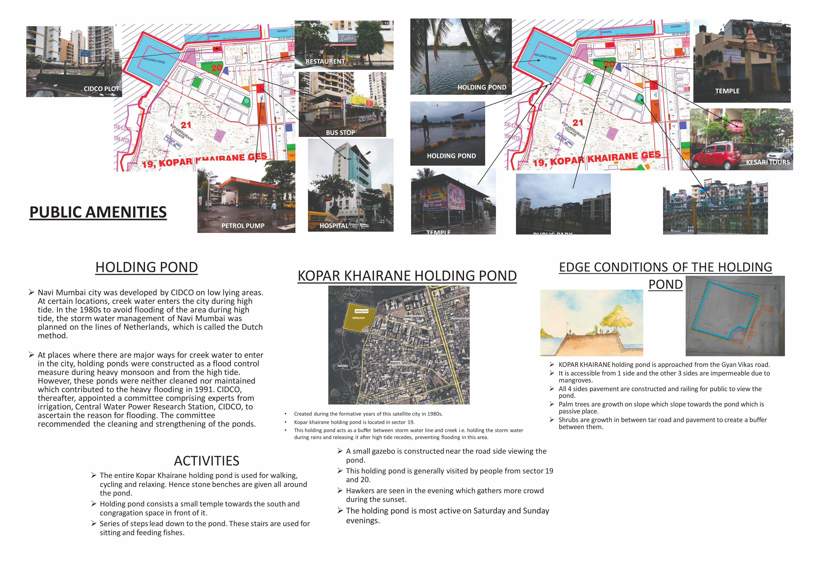
PUBLIC AMENITIES
CIDCO PLOT
CIDCO PLOT
PRIVATE PLOT
PETROL PUMP HOSPITAL
BUS STOP
RESTAURENT
HOLDING POND
HOLDING POND
TEMPLE PUBLIC PARK
TEMPLE
KESARI TOURS
HOLDING POND Navi Mumbai city was developed by CIDCO on low lying areas.
At certain locations, creek water enters the city during high tide. In the 1980s to avoid flooding of the area during high tide, the storm water management of Navi Mumbai was planned on the lines of Netherlands, which is called the Dutch method.
At places where there are major ways for creek water to enter in the city, holding ponds were constructed as a flood control measure during heavy monsoon and from the high tide. However, these ponds were neither cleaned nor maintained which contributed to the heavy flooding in 1991. CIDCO, thereafter, appointed a committee comprising experts from irrigation, Central Water Power Research Station, CIDCO, to ascertain the reason for flooding. The committee recommended the cleaning and strengthening of the ponds.
KOPAR KHAIRANE HOLDING POND
• Created during the formative years of this satellite city in 1980s.• Kopar khairane holding pond is located in sector 19.• This holding pond acts as a buffer between storm water line and creek i.e. holding the storm water
during rains and releasing it after high tide recedes, preventing flooding in this area.
EDGE CONDITIONS OF THE HOLDING POND
KOPAR KHAIRANE holding pond is approached from the Gyan Vikas road. It is accessible from 1 side and the other 3 sides are impermeable due to
mangroves. All 4 sides pavement are constructed and railing for public to view the
pond. Palm trees are growth on slope which slope towards the pond which is
passive place. Shrubs are growth in between tar road and pavement to create a buffer
between them.
ACTIVITIES The entire Kopar Khairane holding pond is used for walking,
cycling and relaxing. Hence stone benches are given all around the pond.
Holding pond consists a small temple towards the south and congragation space in front of it.
Series of steps lead down to the pond. These stairs are used for sitting and feeding fishes.
A small gazebo is constructed near the road side viewing the pond.
This holding pond is generally visited by people from sector 19 and 20.
Hawkers are seen in the evening which gathers more crowd during the sunset.
The holding pond is most active on Saturday and Sunday evenings.
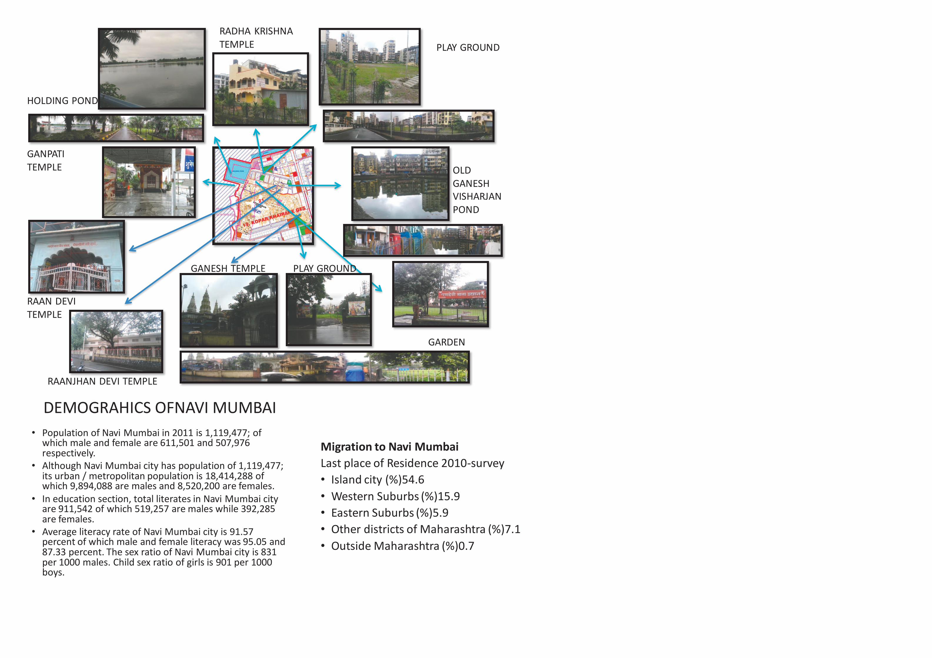
DEMOGRAHICS OFNAVI MUMBAI• Population of Navi Mumbai in 2011 is 1,119,477; of
which male and female are 611,501 and 507,976 respectively.
• Although Navi Mumbai city has population of 1,119,477; its urban / metropolitan population is 18,414,288 of which 9,894,088 are males and 8,520,200 are females.
• In education section, total literates in Navi Mumbai city are 911,542 of which 519,257 are males while 392,285 are females.
• Average literacy rate of Navi Mumbai city is 91.57 percent of which male and female literacy was 95.05 and 87.33 percent. The sex ratio of Navi Mumbai city is 831 per 1000 males. Child sex ratio of girls is 901 per 1000 boys.
Migration to Navi MumbaiLast place of Residence 2010-survey• Island city (%)54.6• Western Suburbs (%)15.9• Eastern Suburbs (%)5.9• Other districts of Maharashtra (%)7.1• Outside Maharashtra (%)0.7
HOLDING POND
RAAN DEVI TEMPLE
GANPATI TEMPLE
RADHA KRISHNA TEMPLE PLAY GROUND
OLDGANESH VISHARJAN POND
GARDEN
RAANJHAN DEVI TEMPLE
PLAY GROUNDGANESH TEMPLE