Embed Size (px)
Citation preview

Irish Hills Ranch Specific Plan Area
Prepared For:
California Polytechnic State UniversityCity and Regional Planning Department
Supervisor:Vicente Del Rio
Authors:
Justin FrentzelAnthony PetrilloPriit KasklaTanya RamirezMike Gibbons

2
Chapter 1: Existing Site and Analysis
1.1 - Site History and Regulation 1.2 - SWOT Analysis 1.3 - Site Analysis and Context
Chapter 2: Guiding Principles
2.1 - Design Principles 2.2 - Precedent Studies
Chapter 3: Design Proposal
3.1 - Vision and Goals 3.2 - Land Use 3.3 - Circulation 3.4 - Neighborhood Form 3.5 - Parks and Open Space 3.6 - Infrastructure and Public Facilities 3.7 - Implementation
References
Table of Contents
3 - 18
4 - 910 - 1718
19 - 25
20 - 2223 - 25
26 - 54
2728 - 3031 - 3637 - 4950 - 515253 - 54
55

Chapter 1 | Existing Site and Analysis
1.1 | Site History and Regulation
1.2 | SWOT Analysis
1.3 | Site Analysis and Context
3
4
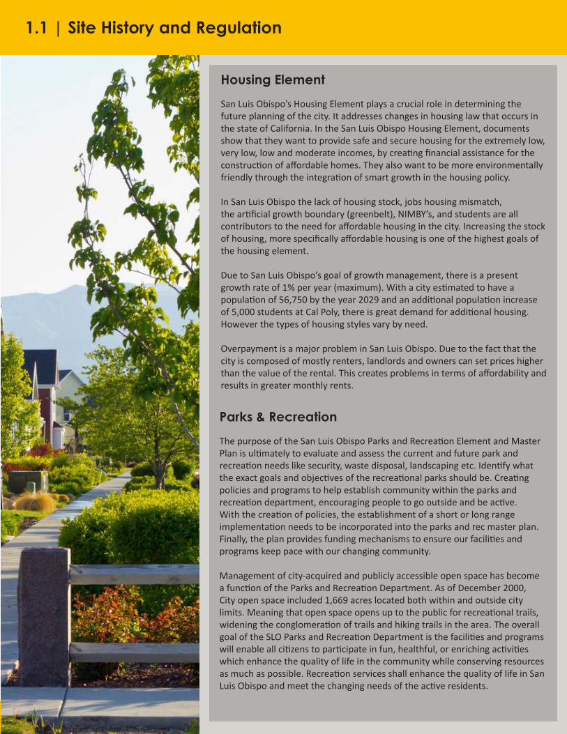
Housing Element
San Luis Obispo’s Housing Element plays a crucial role in determining the future planning of the city. It addresses changes in housing law that occurs in the state of California. In the San Luis Obispo Housing Element, documents show that they want to provide safe and secure housing for the extremely low, very low, low and moderate incomes, by creating financial assistance for the construction of affordable homes. They also want to be more environmentally friendly through the integration of smart growth in the housing policy.
In San Luis Obispo the lack of housing stock, jobs housing mismatch, the artificial growth boundary (greenbelt), NIMBY’s, and students are all contributors to the need for affordable housing in the city. Increasing the stock of housing, more specifically affordable housing is one of the highest goals of the housing element.
Due to San Luis Obispo’s goal of growth management, there is a present growth rate of 1% per year (maximum). With a city estimated to have a population of 56,750 by the year 2029 and an additional population increase of 5,000 students at Cal Poly, there is great demand for additional housing. However the types of housing styles vary by need.
Overpayment is a major problem in San Luis Obispo. Due to the fact that the city is composed of mostly renters, landlords and owners can set prices higher than the value of the rental. This creates problems in terms of affordability and results in greater monthly rents.
Parks & Recreation
The purpose of the San Luis Obispo Parks and Recreation Element and Master Plan is ultimately to evaluate and assess the current and future park and recreation needs like security, waste disposal, landscaping etc. Identify what the exact goals and objectives of the recreational parks should be. Creating policies and programs to help establish community within the parks and recreation department, encouraging people to go outside and be active. With the creation of policies, the establishment of a short or long range implementation needs to be incorporated into the parks and rec master plan. Finally, the plan provides funding mechanisms to ensure our facilities and programs keep pace with our changing community.
Management of city-acquired and publicly accessible open space has become a function of the Parks and Recreation Department. As of December 2000, City open space included 1,669 acres located both within and outside city limits. Meaning that open space opens up to the public for recreational trails, widening the conglomeration of trails and hiking trails in the area. The overall goal of the SLO Parks and Recreation Department is the facilities and programs will enable all citizens to participate in fun, healthful, or enriching activities which enhance the quality of life in the community while conserving resources as much as possible. Recreation services shall enhance the quality of life in San Luis Obispo and meet the changing needs of the active residents.
1.1 | Site History and Regulation

5
Land Use Element
The Urban Reserve Line of San Luis Obispo is a boundary separating urban development from suburban development rural land. This boundary is a reflection of the values of the San Luis Obispo community, which include the importance of protecting open space and maintaining a separation between developed and undeveloped land. There are numerous policies in the Land Use Element of the SLO General Plan which supplement the Urban Reserve Line and support the separation of developed and undeveloped land.
To be consistent with these policies, any proposed development, including the Madonna on LOVR Specific Plan should essentially preserve any currently undeveloped land outside of the Urban Reserve Line. Some appropriate uses within the greenbelt include agriculture, parks and outdoor recreation, and some rural residential development.
The City of San Luis Obispo will manage the growth of the city’s housing supply so that it does not exceed one percent per year, excluding dwelling units affordable to residents with low incomes as defined by the Housing Element. This rate of growth may continue as long as the City’s basic service capacity is assured. Approved specific plan areas may develop in accordance with the phasing schedule adopted by each specific plan provided thresholds established are not exceeded.
The relevant requirements for commercial buildings include that they be developed in areas where the slope of the land is less than 10%, and that they have access from collector and arterial streets. The area may also be suitable for regional attractions including tourism and related facilities (hotels, etc.)
Subdivision Regulations
General Development:- Generally, side lot lines will be perpendicular to the street, unless it is on a curved portion of a street, resulting in the side lot lines being radial. Lot lines need to be appropriately designed around topographical features (top/bottom of slopes, creek banks, etc.). - Lots with a depth-to-width ratio of greater than three are not permitted.- The city discourages multiple frontages single family lots, unless the residence is on a corner- The city may require dedication and improvement of alleys to serve as rear access to parcels in industrial, commercial, and residential subdivisions.
Hillside Development- Keep a low profile and conform to the natural slopes;- Minimize grading on individual lots; generally, locate houses close to the street; minimize the grading of visible driveways;- Include planting which is compatible with native hillside vegetation and which provides a visual transition from developed to open areas;- The grading plan shall ensure that development near or on portions of a hill or mountain do not cause, or make worse, natural hazards (such as erosion, sedimentation, fire, or water quality concerns);
1.1 | Site History and Regulation

6
Subdivision Regulations Cont.
Creekside Development- Creeks and their corridors are to be preserved as open space, and creek corridors are to be maintained in essentially a natural state to protect the community’s water quality, wildlife diversity, and aesthetic value.- Developments along creeks should include public access across the development site to the creek and along the creek; provided, that wildlife habitat, public safety, and reasonable privacy and security of the development can be maintained.- Sensitive habitat, creek corridors and creek setback areas should be protected by preserving such resource areas and associated habitat buffers through easements.
- Solar access should be preserved through the creation of easements preventing development. Easements will be required under the following situations: 1. A plan for building construction and landscaping is approved in conjunction with the subdivision approval, and the plan will provide an acceptable level of solar exposure, as provided in the energy element of the general plan 2. The size and shape of the parcels together with the yard and height restrictions of the zoning regulations will allow subsequent development of each parcel in a way which will not eliminate acceptable solar exposure for neighboring parcels within the subdivision 3. The subdivision is a condominium conversion
Bike Plan
Until San Luis Obispo’s first revision of the Bicycle Transportation plan in 1993, the city did not have any bicycle parking standards. Since then, the city has encouraged bicycle transportation by implementing short and long-term bicycle parking and facilities, “whenever a new structure is erected or enlarged or whenever a new use is established which requires a total of 10 or more vehicle parking spaces.” The cities plan for short-term bicycle parking mainly involves the installment of bike racks/lockers.
In response to this plan, the site of Los Osos and Madonna will have to plan on installing these bike racks at every commercial building parking area. The site will have two city approved rack options to choose from after the amount of bike parking spots is estimated. There are only two city approved bike racks that meet the design guidelines outlined in the Bicycle Transportation plan.
Bikelane Classifications-- Class I Bikeway (Bike Path): “The minimum paved width for a two-way bike path shall be 8 feet...”-- Class II Bikeway (Bike Lane): “... if no gutter exists, the minimum bike lane width shall be 4 feet. With a normal 2-foot gutter, the minimum bike lane width shall be 5 feet.-- Class III Bikeway (Bike Route): minimum widths are not presented in the HDM. The County BAC recommends a minimum 1.5’ paved shoulder beyond the edge of traveled way.
1.1 | Site History and Regulation

7
History
The native people of the area are the Chumash Native Americans, whose tribe dates over 9000 years ago. There aren’t any indications the site has direct ties to the tribe, though considerations should be taken throughout the development process in the case such ties are found.
The Spanish Colonization and Mission Period occurred between 1772-1834, symbolized by the construction of Mission San Luis Obispo in 1772. The development of the mission brought many cattle ranchers to the area. Once Mexico gained independence from Spain in 1821, many land grants were given to cattle ranchers in the area. The treaty of Guadalupe Hidalgo in 1848 granted U.S. citizenship to the Mexican ranchers. These ranchers held much of the land in the area and would sell off their land over the years.
Mr. L. Nelson would acquire over 500 acres including the land which encompasses our site. In 1890 John Froom leased this land to run a dairy. He ended up marrying Mrs. Froom who inherited the land in 1904. One of their sons, Bill Froom, would continue to operate the dairy until 1977 when he sold the land to Alex Madonna, ending the 150+ year run of the working ranch. After acquiring the land, Alex Madonna envisioned 80 acres to be developed into a business park, restaurants, motels, and an auto dealership. His vision would be denied by the city only to have land directly north of his developed for these same purposes.
The main street around our site, Los Osos Valley Road, has connected Los Osos to San Luis Obispo since at least 1877. Highway 101 brings the vast amount of people through the area and lies just south of the site.
Conservation of Open Space
Open SpaceThe goal behind open space is to preserve and protect “valuable natural and agricultural resources” with an emphasis on creeks, grasslands, wetlands, habitats and corridors, prime agricultural land, rock outcroppings, and unique plant and animal communities. Open space must have significant and “wildlife compatible” buffers and setbacks between the open space and activity areas particularly with sensitive habitats or species. Non-vehicular public access is allowed on some open space; however, allowing access must not harm the resources or communities in the area.
Air and Energy The general plan promotes walking, biking, and public transit as well as implementing programs to reduce single occupant gas vehicle trips. For new developments that general plan says land use design should be utilized in order to help reduce single occupant gas vehicle trips. Finally, new technologies should be used that produce the least amount of air pollutants. In efforts to minimize energy usage, buildings should be orientated to utilize natural lighting and cooling. Buildings should also be orientated for solar panel use.
1.1 | Site History and Regulation

8
Conservation of Open Space Cont.
WaterDevelopment on the Madonna at LOVR site introduces risks of pollution to both surface water and groundwater due to an increase of impervious surfaces, like concrete and asphalt. The general plan calls for altering existing drainage patterns and incorporating water holding areas into urban landscape for groundwater retention. Permeable surfaces should be used as hardscape. Community design should be compact, mixed use, walkable, and transit oriented so that automobile generated urban runoff pollutants are minimized and open lands that preserve water are maximized.
Natural CommunitiesNatural communities onsite, habitats and corridors especially for any species listed under the Endangered Species Act must be preserved and protected. Corridors connecting habitats must also be connected without disruption by humans. Fifty percent of the site must be devoted to open space. The plan should look to include areas with natural ecotone and significant trees to be preserved as part of the open space designation. Landscaping on the site shall include the appropriate native plants and replace any non-native, invasive species in the area.
Market Trends
Currently political control for the site remains with the county but a specific plan for low-density family housing has been made by the City of San Luis Obispo. When development begins on site, political control will be transferred over to the City of San Luis Obispo.
Property is in demand due to reduced inventory, as there are more potential buyers and sellers, which make for a soft seller’s market. Due to the high demand, property is often sold for above the listed price. Currently, however, there is a large supply of low to medium income residential housing but the demand for more is so high that the site should continue this trend. Infrastructure on and off the site is so strong that there will be a minimum cost for linkages.
Large markets trends include housing for students, senior living, middle-income families, and tourism.
In general, San Luis Obispo’s population has decreased 3.8 percent from last year due to the higher cost of living in town compared to the surrounding municipalities. Having a cost of living of about $51,000 it is still 22.5 percent lower than the state average. The average home price is almost $660,000, which forces many people to commute into town. With people commuting to and from San Luis Obispo, it has an unemployment rate of 4.9 percent, which is 1.2 percent lower than the state’s level. Affordable residential units for some of the workers of the area would be optimal. To optimize residential and commercial uses, mixed use buildings would be efficient and appropriate to the area.
1.1 | Site History and Regulation

9
Circulation
The city aims to continue and develop policies and programs regarding traffic reduction objectives. The city encourages businesses to work with commuters and work schedules to reduce the number of trips they generate and improve peak hour level of service. These programs are mostly incentivized, and focus of ridesharing and alternative forms of transportation.
San Luis Obispo requires streets be designed as complete, comfortable, safe and convenient for all modes of transportation, and strive for the highest levels of service for each. However, the plan recognizes different locations of the city demand different priorities be placed on certain modes of transportation.The city has invested mainly in the development of a high functioning bus system focused on convenience, cost effective, and speed. The city aims to coordinate with the regional bus line to increase long-range ridership, provide transit stops with ¼ a mile of all businesses and residence, and incentivize development of businesses or medium-high residential uses within 1/8th of a mile of transit services.
The city attempts to create complete pedestrian network connections between residential areas and activity centers/trails to open space. The city also asks the most investment goes into areas where pedestrian activity is likely and would optimize use
The city requires the Access and Parking Management Plan be updated every five years, and consider best practices, such as, unbundled parking, smart parking technologies and cash out programs. The city defines the standards for parking spaces, and provides appropriate data before making parking related requirements/developments (Parking Garages).
1.1 | Site History and Regulation

1.2 | SWOT Analysis
Strengths
Unique topographical conditions and Irish Hills as a backdrop provide uniqueness and visual attractiveness. Beautiful out-views from site.
City’s General Plan discourages beyond development beyond the 150-foot elevation. Large portions of site have inclines larger that 20%.
Topographic conditions provide easy natural drainage.
Natural features provide great potential for recreation and connections to Irish Hills trails and beyond.
Weaknesses
A significant portion of site is within a flood zone.
Site conditions limits ingress/egress opportunities from all sides but from north at LOVR.
Limited on-site vegetation facilitates development but limits its attractiveness and biodiversity.
Site conditions are such that there is excellent sun exposure most of the day. Closer to the western edge Irish Hills generate more intense afternoon shading.
Existing creek provides attractive resource but limits development and adds risk of flooding during rainy seasons.
Geotechnical and soil conditions have yet to be investigated.
Natural Resources
10

Opportunities
Excellent potential for future connections to SLO Bike Network and the Bob Jones Bike trail.
Traffic impact along LOVR and the challenges for transposing HW 101.
Mediterranean climate contributes to quality weather
Nearby Public Golf Course and Laguna Lake Park and open Space.
Threats
Climate and natural conditions may increase risk of wildfires.
Site receives plenty of prevailing cool winds from the Pacific through valley.
11

Strengths Weaknesses
Remaining on-site building structures represent local history/culture but have been very modified along time and are in very poor structural conditions.
Former uses and site history provide potential to incorporate agricultural element to design, but may have negative impacts on type of development.
Cultural Resources
1.2 | SWOT Analysis
12

Opportunities
Central Coast wine industry and tourism is potential for commercial development and design inspiration.
Threats
Proximity of historic California Mission and General Plan suggest architectural consistency with Californian-Spanish style. Although popular, there is a risk of limiting architectural creativity in the development.
Nearby institutions (Cal Poly, PAC, downtown, Sunset Drive-in, etc) and facilities provide some but limited cultural opportunities.
13

Strengths
Site outside Urban Reserve Line adds additional regulatory hurdles for plan approval and development
Easy possibility to hook-up to existing city utility networks.
Weaknesses
No on-site infrastructure
Remaining on-site building structures represent local history/culture but have been very modified along time and are in very poor structural conditions.
Former uses and site history provide potential to incorporate agricultural element to design, but may have negative impacts on type of development.
Infrastructure
1.2 | SWOT Analysis
14
Opportunities
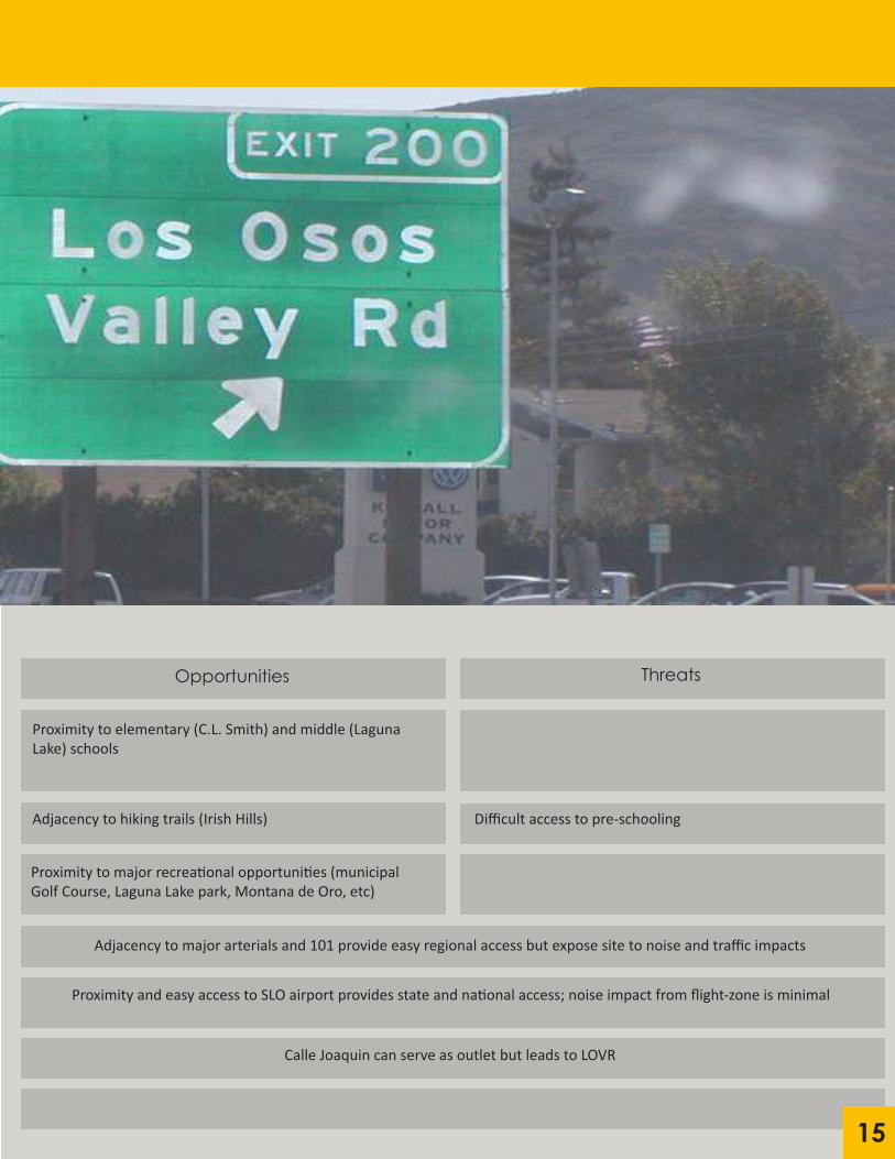
Proximity to elementary (C.L. Smith) and middle (Laguna Lake) schools
Adjacency to hiking trails (Irish Hills)
Proximity to major recreational opportunities (municipal Golf Course, Laguna Lake park, Montana de Oro, etc)
Threats
Difficult access to pre-schooling
Adjacency to major arterials and 101 provide easy regional access but expose site to noise and traffic impacts
Proximity and easy access to SLO airport provides state and national access; noise impact from flight-zone is minimal
Calle Joaquin can serve as outlet but leads to LOVR
15

Strengths
Existing trails and dirt roads through the site Existing barns are old and culturally significant but deteriorated beyond repair and lost most original historical features.
Existing farmhouse is historic and culturally significant.
Existing bio swales helps manage storm water
Weaknesses
Limited site access from the surroundings
Former agricultural use may have contaminated soil
The site is a greenfield / undeveloped parcel
Man-Made Resources
1.2 | SWOT Analysis
16

Opportunities
Easily accessible surrounding groceries, restaurants, hotels, and other commercial facilities.
Existing commercial uses limits types of commercial development on the site.
Threats
Surrounding commercial uses present increased risk for traffic impacts
Adjacency to LOVR and proximity to major arterials provides easy regional access but increase risk of traffic impacts.
Downtown, Cal Poly, near-by office/industrial park provides easy access to jobs, services and commerce, but may restrict possible commercial land-uses on the site.
Proximity to SLO County Airport provides access to state/nation but may generate environmental impacts (noise, safety).
Proximity and easy access to HW 101 and access ramps is a plus but site may be affected by traffic and noise impacts. 17

18
1.3 | Site Analysis and Context

Chapter 2 | Guiding Principles
2.1 | Urban Design Principles
2.2 | Precedent Studies
19

20
Human Scale
Human scale refers to the relation between humans and the built environment. Building details, building height, pavement texture, street trees, and street furniture are all physical elements that contribute to human scale. It is essential that the building widths should be in proportion with buildings heights. Distance also plays a role in human scale. For example at 1,000-1,800 ft humans can identify other people as humans instead of objects. From 80-360 ft individual characteristics and body language can be observed. At less than 25 meters, people enter a “social” field of vision where richness of detail and communication intensify dramatically meter by meter. Playing off of these human qualities, the built environment can ensure human comfort as visitors move from space to space.
Key Features:
- Proportionality between structural base and height- Integrated architectural features across building facades- Established relationship between public and private spaces- Intentional design for visitor comfort and ease- “Cool with a K” - Vicente Del Rio
Multi-Modal Transit and Complete Streets
Improving the physical circulation system of the city can include implementing sidewalks, streets, paths, urban trails, bicycle routes, bridges and highways that are legible and easy for the city’s inhabitants to navigate through. Utilizing street signs that are easily understandable by all people is also one of the important things that should be considered. Effective signage provides a visual linkage between areas and eases wayfinding to landmarks and transit. This allows residents and visitors to move about the city, community, or neighborhood more comfortably and efficiently. For example, Charlotte’s population growth increased its overall need for a higher transportation capacity. Construction of well-integrated road systems, paths, and transit routes, that encourage and allow for different modes of movement in and around the city, will allow air quality and mode choice to improve. Implementation of this principle on the project site will create a well designed and efficient circulation system that enhances the vibrancy of the city.
Key Features:
- Signaled crosswalks- ADA accessible sidewalks- Mid-block pedestrian crossings- Clear separation of right-of-way- Bike lanes- Strong-wayfinding
2.1 | Urban Design Principles

21
Conservation of Natural Resources and Open Space
Well designed places need to balance hardscaped urban areas with softer, natural landscapes. Open spaces in and around cities “provide access, light, air and the setting for buildings” (Planning Guidance). Nature and open spaces also aid in improving the well-being of a city’s citizen, another key urban design principle. Socially, and physical health wise, open spaces provide places for interaction and activity that can serve as a reprieve from the mundane, car-centric society planners are trying to move away from. In many cities, such as Salt Lake City and St. Paul, planners are looking toward opportunities to reclaim natural features that were once dominated by industrial and heavier urban uses (Brown, pp. 110).
Key Features:
- Conservation of natural spaces- Nature restoration- Public access
Variety
The mixing of uses is key to the development of active streetfronts and connected communities. As variety of form and use increases, other key urban design principles like Kevin Lynch’s access, fit, efficiency, etc. are naturally emphasized as the built environment denisifies to bring land uses together. When commercial, residential, open spaces, and public facilities are located in close proximity to one another a functioning urban core is formed from increased social and economic activity. Mixing land uses in urban centers measurably increases property values, general societal happiness, further redevelopment potential, a sense of place and community, and greater environmental and economic resiliency. Alternatively when land uses are isolated, automobile dependency skyrockets and social interaction between residents drops off as rising utility costs disincentives trip formation.
Key Features:
- Differentiation of uses- Increased density- Multimodal optionality- Architectural diversity- Strong private-public connections- Jobs-Housing balance
2.1 | Urban Design Principles

22
Interactiveness
The ultimate reason why planning is important is to create great cities and places that enhance the lives of those that live in them. There are many ways in which the built environment directly affects the live happiness and well-being of the people that live in them. For example, a Swedish study found that people who commute longer than 45 minutes were 40% more likely to divorce. One of the most important things to human beings is their social networks and interactions that keep them connected with others. Certain forms of the city can be conducive to these types of interactions while others can discourage or otherwise hinder them. Any design features of the proposed project should ensure that the happiness and well-being of those that live in the community will be maintained or enhanced.
Key Features:
- Activated streetfronts- Social interaction- Widened sidewalks- Mixed uses
2.1 | Urban Design Principles

23
Case Study: Village Homes
Designed and planned well before the smart growth and new urbanist movements, Village Homes was meant to create a unique sense of community, as well as maintain a sustainable environment for those that live in it. The goals of Village Homes were to “design a neighborhood which would reduce the amount of energy required to carry out the family’s daily activities, and establish a sense of community” (Francis, 26).
The central focus in the design of the layout of Village Homes is open space, around which a residential area is organized. There are a variety of open spaces in the community including private gardens, common areas, agricultural lands, turf areas for sports, and landscaped areas. The pedestrian and bicycle circulation system is separate from the vehicle circulation system, and was laid out first. This system makes it easier to walk or bike throughout the community than to drive, and the greatest travel time from one point within the community to another is five minutes.
Location: Davis, CaliforniaSize: 60 acresPopulation: 650 ResidentsDesigned by: Michael CorbettPlanning: 1973–1975Construction: 1975-1982Land Use: 242 housing units; Commercial Office space: 4,000 sq. ft.; Agricultural uses: 12,000 sq. ft.; 12 acres of common agricultural land
Case Study: Mizner Park
The project is two city blocks on both sides of a grand central public park/open space. Conceived as a neo traditional downtown, the project involves four main mixed-use buildings facing each other across the park and public space to create a visually uninterrupted ambiance. No single-use, stand- alone buildings were planned on this development; any use that can be placed on an upper floor such as offices, housing, or cinemas have been located there; all ground-floor space is used either for retail or for entrances.
Two-thirds of the Mizner Park site is devoted to public areas, such as the amphitheater, broad arcade walkways, and the park/village green, which is dotted with gazebos, benches, and fountains. There are also outdoor dining plazas and apartment balconies overlooking activities below.
Location: Boca Raton, Florida Size: Mizner Park is 27.8 acresArchitect: Cooper Carry & AssociatesYear: 1987-1996 Total Development Cost: $59,544,044 Land Use: 156,000 sq ft of retail space, 136,000 sq ft of residential space (136 dwelling units), 106,000 sq ft of office space, and 1,456 total parking spaces
2.2 | Precedent Studies

24
Case Study: University Village
University Village at Thousand Oaks is a comprehensive retirement community located in Thousand Oaks California, adjacent to the California Lutheran University campus. About 500 residents live on the 65 acre campus, which features a variety of facilities to cater to the community. These facilities include dining rooms, a library, fitness center, theater, computer room, pool, tennis court, bank, and recreational open spaces.
Residents of University Village are given long-term care and support services, which include medical care, house cleaning, laundry service, maintenance, security protection, and the arrangement of appointments and activities.
Location: Thousand Oaks, CaliforniaSize: 65+ acresPopulation: ~500Architects: Perkins EastmanYear: 2000Land Use: variety of senior housing, including villas, garden terrace residences and apartment homes, resident and community facilities (dining, lounge, library, recreation, theater, garden, fitness)
Case Study: Celebration, FL
Originally conceived by the Walt Disney Company as a community just outside of their Walt Disney World Resort in Florida, Celebration was very much rooted in New Urbanist ideals. Land uses in the downtown district were mixed to encourage alternate transportation. Bicycle and walking trails are strung throughout the city to facilitate active lifestyles. Open space was preserved, particularly on the outer rim of the city, to give Celebration a natural buffer to the highway running on the north side of town. Lastly, housing uses were varied to accommodate all sorts of homeowners.
Unfortunately, Celebration has flopped in providing an affordable and desirable place to live. Stringent regulatory measures are in place to discourage long-term rental units. Moreover, the downtown has lost many of its retailers, leaving a good number of storefronts empty.
Location: 22 miles southwest of Orlando, FloridaSize: ~10 square milesFounded: 1994Estimated Cost: 2.5 Billion US DollarsPlanning/Construction: 1990-1996Land Uses: ~4,100 Housing Units, ~60 acre Hospital/Medical Center, Education, Office, and Assorted Retail
2.2 | Precedent Studies

25
Case Study: Santana Row
Located only 3.5 miles from downtown San Jose, Santana Row stands as a prime example of a high density mixed use planned community project. The one billion dollar project was a result of San Joses 2020 General Plan that emphasizes further economic development and to generate a more robust and stable tax base.
The main point of the development was to create a unique mix of shopping, dining, entertainment and living designed to enhance the individual experience. The backbone of the project is a 1,500-foot Mediterranean main street with curbside landscaping, wide sidewalks and intimate seating areas. Urban lofts with ground floor retail line the main street and green spaces and high-quality landscaping are woven into the pedestrian streetscape.
Location: San Jose, CaliforniaSize: 43 AcresPopulation: 1,200 Luxury Rental UnitsDesigned by: SB Architects Year: 2002Land Uses: 1,200 apartments, 680,000 sq retail space, 214 room boutique hotel, 5,200 parking spaces
Case Study: Orenco Station
The Orenco Station is a community in Hillsboro, Oregon, that is centered around a light-rail station served by the Portland METRO system. The community is primarily mixed-use in the center of the community, with more residential uses on the periphery. The developer and the planners of the city of Hillsboro worked to turn the former commercial nursery into a high-density TOD community. The plans called for much narrower streets (20 feet) to promote walking as a primary form of everyday transportation. Additionally, many residential lots have a maximum setback to increase residential densities, up to 18 units-per-acre.
Location: Neighborhood in east-central Hillsboro, ORSize: 209 acresPopulation: ~2600Designed by: Capacity Commercial GroupYear: 1993Land Uses: ~1,800 housing units, town center, transit stop, mixed-use buildings, parks, restaurants, and other retail uses
2.2 | Precedent Studies

Chapter 3 | Design Proposal
3.1 | Vision and Goals
3.2 | Land Use
3.2 | Circulation
3.4 | Neighborhood Form
3.5 | Parks and Open Space
3.6 | Infrastructure
3.7 | Implementation
26

27
Vision StatementThe Irish Hills Ranch will complete the developed Los Osos Valley Road corridor with attractive retail shops, provide much needed housing for the San Luis Obispo community, as well as create a base for outdoor recreational activities within the Irish Hills Natural Preserve. The Specific Plan will utilize surrounding infrastructure and commercial development to create a more attractive and welcoming neighborhood for both residents and the greater San Luis Obispo community to enjoy.
- Consider the Urban Reserve Boundary and limit the spread of new development into the surrounding open space.- Respect the existing environment, including landforms and wildlife, when siting buildings and infrastructure.- Provide a mixture of uses and building sizes where appropriate.
Goal: Land Use
- Provide access to and from the site for multiple modes of transportation.- Establish strong connections between the existing trail system and new development.- Provide access to the site from multiple access points.
Goal: Circulation
- New development should maintain San Luis Obispo’s small town character and identity.- Provide a variety of housing options for all socio-economic statuses.- Maintain consistency with the surrounding architectural style, as well as existing regulations and neighborhood sentiments.
Goal: Neighborhood Form
- Improve landscaping and encourage variety and quality of public spaces.- Restore and incorporate existing historical structures into quality public amenities.- Maintain the visual character and quality of the natural environment on the site.
Goal: Parks and Open space
- Provide infrastructure to protect new development from natural disasters.- Create a hub for recreational activities on site.- Utilize the highest quality, most sustainable infrastructure to minimize any environmental impacts.
Goal: Infrastructure and Public Facilities
3.1 | Visions and Goals

28
3.2| Land Use
Intent The Land Use Chapter of the Irish Hills Ranch Specific Plan presents the Land Use Plan and describes and illustrates the desired form, character, and uses of the Plan Area. The illustrations and examples in this Chapter represent the vision for a complete neighborhood form connected by an open space network. The entire site is City’s greenbelt, but within the City’s sphere of influence and identified for future development. As proposed, the land uses and densities are consistent with the City of San Luis Obispo General Plan Land Use Element, configured to meet the goals and objectives of the Irish Hills Ranch Specific Plan. These goals and objectives also work within the existing land use constraints, including agricultural preservation, the airport, wetlands, wildlife, and floodplain. This chapter also outlines the general policies and objectives for Irish Hills Ranch as established in the City’s Land Use Element.
Objective 1: Consider the Urban Reserve Boundary and limit the spread of development into surrounding open spaces.
Policy 1.1: A minimum of 50% of the site must be reserved as open space. Policy 1.2: No development shall occur past Froom Creek. Policy 1.3: Any development outside of the Urban Reserve Boundary shall be fully compliant with the City of San Luis Obispo’s General Plan requirements.
Objective 2: Respect the environment, including landforms and wildlife, when siting buildings and infrastructure.
Policy 2.1: Froom Creek’s existing creekbed shall be restored and reinforced to protect against future floods while still providing a natural habitat for native species. Policy 2.2: The bio-swale adjacent to Los Osos Valley Road shall be continued along the edge of the site. Policy 2.3: Existing trees shall be either preserved on site or moved to another appropriate location.
Objective 3: Provide a mixture of uses and building sizes where appropriate.
Policy 3.1: A dense, mixed-use core shall be established to provide amenities for both residents of the site and incoming shoppers. Policy 3.2: Residential densities shall decrease from high density to low density moving south through the site from the mixed-use core. Policy 3.3: Commercial uses shall be located in close proximity to existing commercial uses adjacent to the site.
Land Use Categories:
Conservation/Open Space: The C/OS zone will be applied to areas most suitable for open space uses because of topography, geology, vegetation, soils, wildlife habitat, scenic prominence, agricultural value or flood hazard. The C/OS zone is intended to prevent exposure or urban development to unacceptable risks posed by natural hazards and to protect natural resources from disruptive alterations. To these ends, it is further intended to prevent the subdivision of such lands. Commercial: The C-R zone is intended to provide for a wide range of retail sales, business, personal and professional services, as well as recreation, entertainment, transient lodging and some residential uses. The land uses allowed in this zone will serve the entire community and the region, as well as tourists and travelers. The C-R zone implements and is consistent with the general retail land use category of the general plan, and is intended to be applied primarily to areas with more public exposure on arterial streets than those reserved for manufacturing.

29
High Density Residential: The R-4 zone is intended to provide housing opportunities for smaller households desiring little private open space and to provide various types of group housing. It is further intended to allow for the provision of housing in close proximity to concentrations of employment and college enrollment, in areas largely designated R-4.
Medium-High Density Residential: The R-3 zone is intended primarily to provide housing opportunities for smaller households desiring little private open space and to provide various types of group housing. These areas are generally close to commercial and public facilities serving the whole community and generally committed to this type of development.
Low Density Residential: The R-1 zone is intended primarily to provide housing opportunities for people who want a private open space associated with individual dwellings. It is intended to preserve existing single-family neighborhoods, provide for compatible infill development in such areas, and prescribe the overall character of newly subdivided low-density areas.
Public Facility: The P-F zone is intended to provide for the wide range of public uses likely to be located on public property. Public uses are those conducted by governmental or nonprofit agencies. However, this zone will also provide for complementary private and commercial uses which, within the overall guidance of the general plan, provide a public benefit. The zone is further intended to protect neighboring private uses from potentially incompatible public uses.
Mixed-Use: The M-U overlay zone, in combination with any other zone, requires a mix of residential and nonresidential uses on the same site, where mixed use development would otherwise be optional. The primary purpose of the MU overlay is to provide a means for the city to identify areas where the public health, safety, and welfare will be enhanced by requiring that all allowed development be in the form of mixed use projects, where ground floor street frontages are occupied by retail, business or personal services uses with residential uses above, or to the rear of a site. The MU overlay is intended to promote a compact city, to provide additional housing opportunities (including affordable housing opportunities), which is the first priority, and to reduce auto travel by providing services, jobs, and housing in proximity. The city desires the safety provided by having residential components in commercial areas.
Housing Solution:
In order to comply with the City of San Luis Obispo’s Regional Housing Needs Assessment (RHNA) while maintaining the small town feel of the City, development within the plan area shall represent a wide range of housing typologies, consistent with the zoning designations above. Residential density on the site should increase with increased proximity to the proposed mixed use core, while gradually phasing to lower densities toward the Highway 101 corridor. This is to ensure a wide range of housing sizes, pricing, and visual flow through the site.
3.2 | Land Use

30
Consolidated Land Use Matrix
3.2 | Land Use
31
3.3 | Circulation
Intent
This particular chapter of the Specific Plan describes the program of transportation improvements that support circulation throughout the mixed use core and residential neighborhood. The main objective for plan is to make the development easily accessible by all forms of transportation and provide a safe, convenient, and walkable experience for pedestrians.
The following three objectives and related policies describe the transportation improvements and implementations that will contribute to the emergence of Irish Hills Ranch as a vital mixed use community.
Objective 1: Provide access to and from the site for multiple modes of transportation.
Policy 1.1: Implement complete streets throughout the development to ensure that both vehicles, bicyclists, and pedestrian have safe and convenient access to and from the site. Policy 1.2: Create a bus stop at the intersection of Creekside Terrace and Auto Park Way Policy 1.3: All sidewalks on site shall be no less than five feet in width.
Objective 2: Establish strong connections between the existing trail system and new development.
Policy 2.1: Create a trail head adjacent to Palo Verde Loop and provide street parking for hikers and walkers. Policy 2.2: Configure current trails on site so that they converge at the recreational hub. Policy 2.3: Implement complete streets throughout the development to ensure that new streets act as an extension of the existing trails on site.
Objective 3: Provide access to the site from multiple access points.
Policy 3.1: Create intersection at Calle Joaquin that connect to Creekside Terrace. Policy 3.2: Extend Auto Park Way into the site, creating an intersection at LOVR and Auto Park Way. Policy 3.3: Create a connection to Creekside Terrace that connects to the current parking lots located to the North of the site.
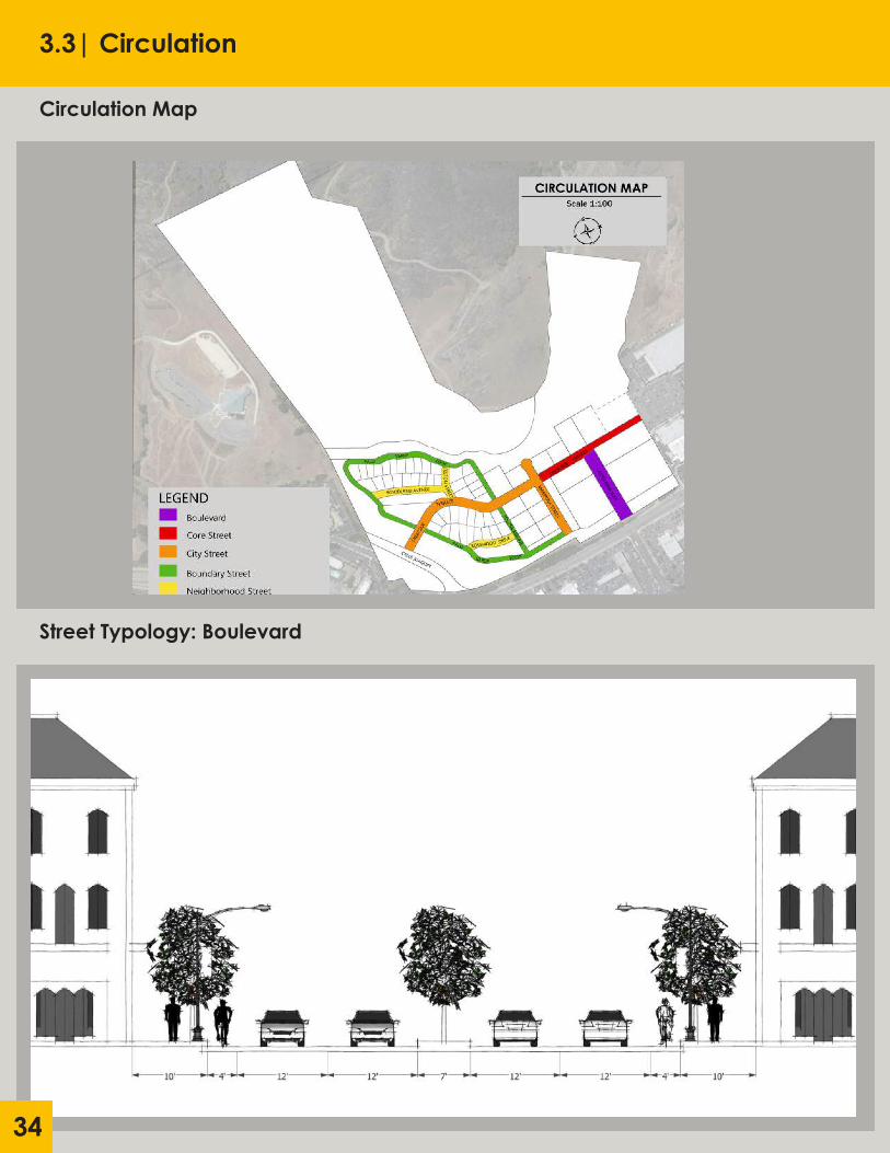
Circulation Typology and Standards:
The Irish Hills Ranch development is located adjacent to U.S. Highway 101 and Los Osos Valley Road—a main corridor through San Luis Obispo. The development has been designed and laid out to ensure that the needs of pedestrians and drivers are met. Within the site are designated parking lots, parking spaces, and a two level parking garage. Bicyclists are provided with safe and convenient travel within the site due to the bicycle oriented complete streets. Irish Hills Ranch also provides residents and patrons alike with safe and walkable streets. All the streets on site have sidewalks that range from 5-12 feet in width. Additionally, new trail heads will be created that connect to the current trails on the property. Street types have been determined based on the location of the street and the role it is expected to play in the developments circulation and formation of public space. The street types envisioned for the site are described below:
1) Boulevards
Boulevards will provide a safe, convenient, and visual pleasing connection to the site.
Standards a. The right-of-way provided for the Boulevard shall be no less than 84 feet in width. b. A landscaped median shall be provided with a single row of large deciduous trees planted at a maximum spacing of 30 feet.
32
c. A single species of medium deciduous trees shall be planted in parking lanes in wells with trees planted at a maximum of spacing of 50 feet. d. Pedestrian-scale decorative street lighting shall be placed within the sidewalk at a max spacing of 70 feet.
2) Core Street
Core Streets will provide comfortable and safe connectivity within the retail and entertainment heart of Irish Hills Ranch.
Standards a. The right-of-way provided for the Core Street shall be no less than 58 feet in width b. A single species of medium deciduous trees shall be planted in parking lanes in wells with trees planted at a maximum of spacing of 50 feet. C. Pedestrian-scale street lighting shall be placed within the sidewalk at a maximum spacing of 70 feet.
3) City Street
City Streets will provide attractive and comfortable, yet versatile connections within the urban fabric.
Standards a. The right-of-way provided for the Core Street shall be no less than 58 feet in width b. A single species of medium deciduous trees shall be planted in parking lanes in wells with trees planted at a maximum of spacing of 45 feet. C. Pedestrian-scale street lighting shall be placed within the sidewalk at a maximum spacing of 80 feet.
4) Boundary Street
Boundary Streets will provide passages that supply critical linkages in the neighborhood area on a narrow right-of-way. Standards a. The right-of-way provided for the Boundary Street shall be no less than 30 feet in width. b. A single species of medium deciduous trees shall be planted in parking lanes in wells with trees planted at a maximum of spacing of 45 feet. C. Pedestrian-scale street lighting shall be placed within the sidewalk at a maximum spacing of 80 feet.
5) Neighborhood Street
Neighborhood Street will provide safe, functional, and attractive connections to the surrounding public right-of-way.
Standards a. The right-of-way provided for the Neighborhood Street shall be no less than 56 feet in width. b. A landscaped median shall be provided with two rows of large deciduous trees planted at a maximum spacing of 30’ with a single pedestrian sidewalk in between them. c. A single species of medium deciduous trees shall be planted in parking lanes in wells with trees planted at a maximum of spacing of 45 feet. d. Pedestrian-scale street lighting shall be placed within the sidewalk at a maximum spacing of 80 feet.
3.3 | Circulation

33
Parking
Parking requirements for development parcels shall remain consistent with the San Luis Obispo General Plan and Municipal Code, and the individual land use designations designated within.
Public Transit, Pedestrian, and Bicycle Facilities
In order to promote non-vehicular transit, the site shall incorporate extension of the SLO transit bus route 4 along boulevard, core, and city street typologies. Pedestrian and bicycle infrastructure shall be provided in the form of sidewalks and bicycle lanes along all streets in the plan area, in a manner consistent with the above street typology designations.
3.3 | Circulation
3.3| Circulation
Circulation Map
Street Typology: Boulevard
34

3.3| Circulation
Street Typology: Core Street
Street Typology: City Street
35

3.3| Circulation
Street Typology: Neighborhood Street
Street Typology: Boundary Street
36

37
3.4 | Neighborhood Form
Intent The Neighborhood Form section of the Irish Hills Ranch Specific Plan is designed to provide guidelines for the visual form of future development within the plan area. The goal of this section is to provide the user an understanding of the design elements required to keep new development consistent with the urban context of San Luis Obispo while enhancing the built environment to better comply with the urban design principles laid out in chapter 2 of this document.
Objective 1: New development should maintain San Luis Obispo’s small town character and identity.
Policy 1.1: All new development must comply with existing land use regulations underneath the San Luis Obispo General Plan. Policy 1.2: Adjacent parcels shall not shall not exceed twice another adjacent parcel’s FAR without a change in land use designation. Policy 1.3: Multi-storied buildings must preserve view corridors irregardless of maximum allowable height.
Objective 2: Provide a variety of housing options for all socio-economic statuses.
Policy 2.1: All residential development within the plan area shall comply with minimum and maximum densities laid out herein according to their individual land uses. Policy 2.2: New housing developments on-site shall offer a diverse selection of housing styles, including variation in size, number of bedrooms, bathrooms, and amenities. Policy 2.3: New development projects within the plan area shall provide a variety of housing prices.
Objective 3: Maintain consistency with surrounding architectural styles, as well as regulatory and neighborhood sentiments.
Policy 3.1: Adjacent parcels with similar uses shall maintain a consistent visual theme. Policy 3.2: Architectural and decorative elements should embrace local artistry by utilizing materials and furnishings from regional suppliers. Policy 3.3: Development within the plan area must consider neighborhood sentiment by making project plans available for public comment prior to submittal for architectural review.
Development Standards by Land Use Designation:
1) Commercial
Commercial structures are key to the effective operation of any City. By conveniently providing access to essential goods and services, activating street fronts, and providing opportunity for social interaction commercial uses make up the backbone of the regional economy and enhance the urban environment.
Standards a. Commercial structures shall be street facing, unless deemed allowable by vote of the Planning Commission. b. Commercial parcels shall encourage varied facades, irregardless of number of tenants.
2) Low Density Residential
Low Density Residential uses serve as a buffer region from the surrounding neighborhoods into the urban core of the plan area. They are important for creating diversity in population makeup and diversity in housing options.
Standards

38
3.4 | Neighborhood Form
a. Adjacent housing units shall have a consistent visual theme, which shall be consistent with following architectural and design guidelines. b. Housing developments shall incorporate a mixture of 2, 3, and 4 bedroom homes to encourage diversity.
3) Medium Density Residential
Medium density housing serves to further diversity in housing options and typology while again acting as a visual transition from lower-density uses to the plan-area’s central core.
Standards a. Medium density residential designations shall have attached dwelling units that are street facing. b. Housing units shall have ground floor parking spaces available for resident use. c. Medium density developments shall create visual tiering between adjacent uses with varying built heights.
4) High Density Residential
High density residential uses serve to activate the urban core areas by congregating residents. These zones create vibrant neighborhoods and help San Luis Obispo achieve job-housing balance.
Standards a. High-density residential designations shall include a variety of studio, 1, and 2 bedroom housing units b. High-density residential uses shall include access to open and community spaces.
5) Mixed Use
Mixed-Uses are the core of the plan area. These varied uses serve jointly as commercial-retail, office, and residential uses and help to create a pleasant and active downtown core.
Standards a. Ground floor of any mixed use designations shall consist of either commercial-retail or office uses. b. Similarly to commercial designations, mixed use structures shall have varied facades irregardless of tenants. c. Upper floors of any mixed use structure shall consist of office and/or residential uses.
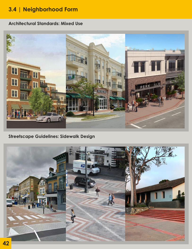
Streetscape Guidelines:
Sidewalk Design Guidelines Sidewalk and pavement design is essential for making pedestrian friendly streets. Developments within the plan area should seek to create pavements that clearly delineate automobile right of ways from those of pedestrian and bike right of ways. Contrasting a warmer-colored concrete base with cooler or even decorative slate to depict areas of transition in semi-public plazas or at key intersections increase overall legibility and safety. Development is encouraged to combine these visual tactics with raised crossings within the plan’s urban core area to help create a consistent and walkable ‘downtown’ neighborhood.
Street Light Design Guidelines Light is a defining feature for comfortable design, and without proper consideration public spaces quickly lose nighttime safety and walkability. In order to avoid this loss and promote a charming, small town yet contemporary feeling for the site staff recommends several design guidelines. In order to promote walkability along pathways and shared pedestrian-automobile roadways, streetscapes should feature well-spaced, lighted

39
bollards. Furthermore, lamp-style overhead lighting is needed to generally distribute bulk lighting while avoiding the inhuman feel of traditional “L-shaped” overhang lighting.
Street Furniture Design Guidelines The most successful activated streetscapes utilize street furniture as a tool for creating pleasant outdoor spaces. A good mixture of fixed and movable chairs/benches, tables for eating, receptacles for garbage and recycling, etc. extend the usefulness of our public spaces, and should be carefully considered as part of any development within the site.
Street Tree Design Guidelines
Trees are not only visually appealing, but are useful for making outdoor public spaces more livable through the shade they provide. This plan seeks developments to utilize street trees with high clear heights placed alongside roadways to create consistent visual themes and increase overall walkability on the site.
Landscaping Design Guidelines
Good landscaping is key for breaking apart hardscapes and improving the visual environment. Landscaping should be utilized within the plan area to enhance paths, street furniture, and plazas.
Public Art Design Guidelines
High quality public art is key for creating a place’s unique identity. Public art should be placed at key intersections, within public plazas, and in parks to enforce the plan area’s legibility. Developers within the site area are encouraged to embrace local artistry as a part of any semi-public spaces, with a particular emphasis on interactive or water based features that create a playful decorum around their placement.
Signage Design Guidelines
Signage and wayfinding are incredibly important for creating walkable and familiar designs. Signage within the site area should avoid traditional ‘lollipop” style signs and instead embrace signs with a unique, yet consistent visual language.
All development within the Specific Plan area must maintain visual consistency with the above design guidelines. Although these guidelines may be interpreted differently depending on future context, this plan generally means to encourage the inclusion of regional art and materials, consistent design features, and overall safety/walkability. The following pages are dedicated to assisting in visualization of these themes and furnishings consistent with the vision of this specific plan.
3.4 | Neighborhood Form

3.4 | Neighborhood Form
Architectural Standards: Commercial
Architectural Standards: Low Density Residential
40

3.4 | Neighborhood Form
Architectural Standards: Medium Density Residential
Architectural Standards: High Density Residential
41
3.4 | Neighborhood Form
Architectural Standards: Mixed Use
Streetscape Guidelines: Sidewalk Design
42

3.4 | Neighborhood Form
Streetscape Guidelines: Sidewalk Street Lights
Streetscape Guidelines: Street Furniture
43

3.4 | Neighborhood Form
Streetscape Guidelines: Trees
Streetscape Guidelines: Landscaping
44

3.4 | Neighborhood Form
Streetscape Guidelines: Public Art
Streetscape Guidelines: Signage
45
3.4 | Neighborhood Form
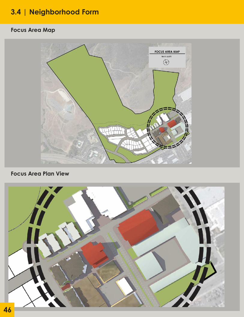
Focus Area Map
Focus Area Plan View
46

3.4 | Neighborhood Form
Focus Area Perspective #1
Focus Area Perspective #2
47

3.4 | Neighborhood Form
Focus Area Perspective #3
Focus Area Perspective #4
48
3.4 | Neighborhood Form
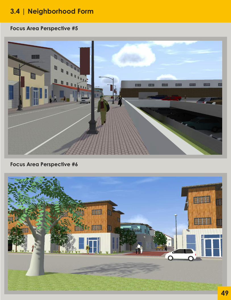
Focus Area Perspective #5
Focus Area Perspective #6
49

50
Intent With half of the site set aside for conservation, open space, and parks, Irish Hills Ranch takes an integrated, comprehensive approach to planning open and recreational spaces for both residents and visitors to the site. The design focuses on connecting open spaces throughout the neighborhood, expanding the City’s network of parks and paths, protecting natural resources, preserving the City’s agricultural character, and contributing to a sustainable future. An objective of the City’s Parks and Recreation Element is to ensure that new developments provide needed parkland for new residents. The Irish Hills Ranch Specific Plan enhances the City’s open space by introducing new amenities, including adding key links between the Neil Havlik Way, Froom Creek Trail, and active linear parks. This chapter also outlines the general policies and objectives for Irish Hills Ranch as established in the City’s Parks and Recreation Element. This chapter also illustrates the overall open space concept for Irish Hills Ranch.
Objective 1: Improve landscaping and encourage variety and quality of public spaces.
Policy 1.1: New trails shall be established throughout the reserved open space of the site, connecting to the existing trail system. Policy 1.2: A large park shall be created near the historical structures featuring a variety of sports fields and other recreational spaces for both residents and visitors. Policy 1.3: The restored creekbed shall feature bicycle and pedestrian paths along it’s course through the site.
Objective 2: Restore and incorporate existing historical structures into quality public amenities.
Policy 2.1: The existing historical structures shall be restored and transformed into public facilities that function as a base for outdoor recreation. Policy 2.2: The new, expanded trail system shall connect to the restored historical structures. Policy 2.3: Any new structures built in association with the existing historical structures shall be consistent with the visual qualities and design of those historical structures.
Objective 3: Maintain the visual character and quality of the natural environment on the site.
Policy 3.1: A minimum of 50% of the site shall be reserved as open space. Policy 3.2: Buildings shall be no taller than 50’ to protect the viewshed of the surrounding hills. Policy 3.3: Buildings must comply with architectural guidelines and maintain consistency with the visual character of surrounding buildings.
Conservation Principles:
Balance: Development must balance hardscaped areas with natural landscapes to improve the well-being of a city’s citizen.
Variety: The mixing of land uses is key to the development of active street fronts and connected communities. Mixing land uses in urban centers measurably increases property values, general societal happiness, further redevelopment potential, a sense of place and and community, and greater environmental and economic resiliency.
Human Scale: Human scale refers to the relation between humans and the built environment. The scale, design, and visual character of the built environment should be comfortable and comprehensible to the people interacting in these spaces.
3.5| Parks and Open Space

51
3.5| Parks and Open Space
Trails and Open Space Map
Multi-modal Transit and Complete Streets: The circulation network of the city should include accommodation for all modes of transportation. Paths of circulation should be well connected to allow efficient travel for people to and from their destinations.

52
Intent Servicing new development within the plan area requires significant expansion of existing infrastructure. Policies within this section will help to guide infrastructure development to better comply with City and State mandates, as well as protect the natural environment.
Objective 1: Provide infrastructure to protect new development from natural disasters.
Policy 1.1: Protect future development through the use of previous pavement on public right of ways. Policy 1.2: Reinforce and restore Froom Creek’s creek bed for better floodwater protection. Policy 1.3: Create redundancy within road-network to allow for quick and safe evacuation if needed.
Objective 2: Create a hub for recreational activities on site.
Policy 2.1: Designate land for community center alongside the Southern edge of the site. Policy 2.2: Restore historic structures on-site to service existing and newly formed trails. Policy 2.3: Expand the existing trail network through the Irish Hills to connect with activity centers within the plan area.
Objective 3: Utilize the high quality, sustainable infrastructure to minimize any environmental impacts.
Policy 3.1: Expand existing LOVR corridor bio-swale to offset chemical run off from adjacent roadways. Policy 3.2: Institute gray-water collection systems that feed maintenance of public landscaping. Policy 3.3: Minimize encroachment on wetland areas through boundary streets along residential corridors.
3.6 | Infrastructure and Public Facilities

53
Intent This section is dedicated to guiding the development of the Irish Hills Specific Plan Area. It will identify the three tiered system for plan adoption and implementation beginning with the development of the Downtown Core district, followed shortly by a joint development phase made up of the first stage of residential development in conjunction with a recreational hub, finished with the second phase of residential development. Each phase brings with it is own benefits, and this section will give the user an idea of the forecasted time frame and benefits from each stage of the development.
Phasing Map
3.7 | Implementation

54
Timeline Vesus Benefit Matrix
3.7 | Implementation
55
References
City of San Luis Obispo General Plan: http://www.slocity.org/government/department-directory/community- development/planning-zoning/general-plan
City of San Luis Obispo Municipal Code: http://www.codepublishing.com/ca/sanluisobispo/
Orenco Station Project: http://www.terrain.org/unsprawl/10/
Santana Row Project: http://www.bizjournals.com/sanjose/news/2014/03/21/the-santana- row-conundrum-is-san-joses-future.html
http://www.santanarow.com/files/Santana_Row_10_Year_Anniversary. pdf
http://www.federalrealty.com/properties/santanarow/
Celebration Florida Project: http://www.celebration.fl.us http://gizmodo.com/celebration-florida-the-utopian-town-that-america- jus-1564479405
http://celebrationtowncenter.com
Base Maps: RRM Architecture, Google Inc.
Environmental Assistance: Adrienne Greve
Transportation Assistance: Cornelius Norwusoo
General Assistance: Vicente Del Rio, Kai Lordfarmer
Site Images: Vicente Del Rio