Embed Size (px)
Citation preview

Geohistory-Géohistoire Canada:
Developing a partnership for
historical GIS and mapping in
Canada
October 20, 2016 NACIS conference
Byron MoldofskyGIS and Cartography Office, Department of Geography
Project Manager
With contributions from
Marcel Fortin
Map and Data Library
Prinicipal Investigator
University of Toronto
Kevin Roy, RA, University of Toronto
Haydi Wong, RA, University of Toronto
James Clifford, collaborator, University of Saskatchewan
Glenn Brauen, collaborator, University of Toronto at Scarborough

Why a Canadian Historical GIS Partnership?
INFRASTRUCTURE, COMMUNITY, COLLABORATION
Especially for Historians, Librarians, Private researchers
without access to or a lot of expertise in GIS
• Work to establish research infrastructure
• Work to enable research collaboration
• Work to enable research communication
(between researchers and with the public)
• Work to share Canadian HGIS resources
(avoid duplication / “re-digitizing the wheel”)

Examples of Other National HGIS Agencies or
Projects

Share Data discovery tools – possibly tying in
existing systems (also meta-data, standards …)
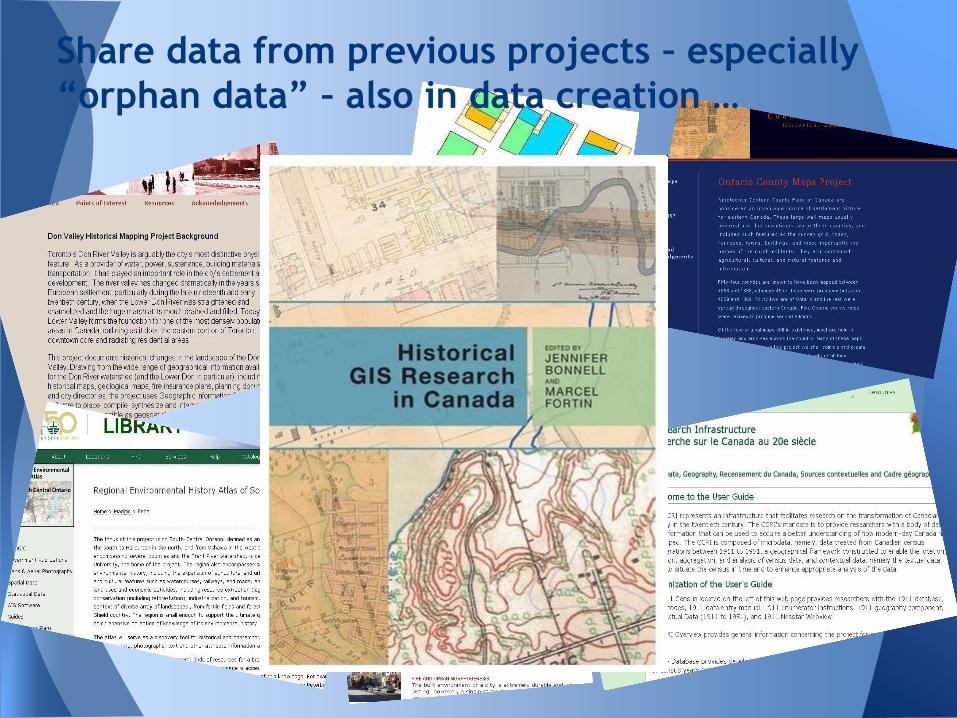
Share data from previous projects – especially
“orphan data” – also in data creation …
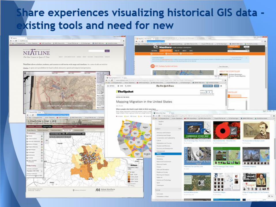
Share experiences visualizing historical GIS data -
existing tools and need for new

Submitted November 2014
Canadian Historical Geographic Information Systems
Partnership
Development grant – so only modest funding, for
building the partnership and pilot projects
Partners and Collaborators from across the country and
across disciplines
Results of competition announced Aug 2015 –
2-yr Time frame to September 2017
SSHRC Partnership Development Grant
Proposal

The Canadian HGIS Partnership will work towards its goals
by achieving the following objectives over the course of
a two year period:
1. Build and expand a network of Canadian researchers and
community members engaged in Historical GIS (Year 1)
2. Produce and disseminate a series of White Papers on HGIS
methods (Year 1)
3. Develop HGIS-specific implementation standards for Geospatial
data structure and for Research Data
4. Build a pilot version of an open, accessible
Historical GIS data portal.
5. Build a pilot version of an open, accessible interactive mapping
website.
Mid-project conference was June 20, 2016 to share results AND
gather feedback and input for next year’s development
Objectives of proposed project

The Canadian HGIS Partnership - Year 1: White Papers
1. Evolution of Historical GIS development in Canada
2. Survey/inventory/catalogue of Canadian HGIS datasets
3. Standards for historical Geospatial data, focusing on
those for Research Data Management and Preservation
4. Historical GIS visualization methods: Existing and
emerging, concentrating on web-mapping
5. Historical GIS Geoportal Development
6. Historical GIS Educational Impacts: HGIS in the
Community and Classroom
White Papers on Historical GIS methods (Year 1)

1. Brief overview of HGIS web-geovisualization landscape.Brief review of literature, discussion of best practices, few selected
example websites
2. Classification of current web geo-visualization technologies
Types of technologies, and which are more or less suitable to different
HGIS needs
3. Evaluation of selected technologies through three methods:
a) Standardized descriptive comparison of different methods
b) Competitive analysis study rating different technologies for
functionality and ease of use
c) Users needs assessment survey made available online for HGIS web-
mapping users, designers and developers
4. Results of Canadian Historical Web-mapping User Needs Survey
5. Developing principles of practice for Canadian HGIS web-mapping
activities, and plan to implement these in our Partnership
development pilot
Whitepaper: Historical GIS visualization/web-mapping

Conceptual model: Figure 3. Roth's re-working of MacEachren’s “Cartography cube” (Roth 2013)
2. Classification of web geo-visualization technologiesTypes of technologies, and which are more or less suitable to different
HGIS needs
Primarily
presentation
Primarily
interaction
Roth, R. E. (2013). Interactive maps: What we know and what we need to know. Journal of Spatial Information Science, (6), 59-115.

Draft version
Classification
of web
geo-visualization
technologies more
or less suitable
for HGIS
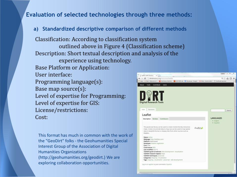
a) Standardized descriptive comparison of different methods
Evaluation of selected technologies through three methods:
Classification: According to classification system outlined above in Figure 4 (Classification scheme)
Description: Short textual description and analysis of the experience using technology.
Base Platform or Application:User interface:Programming language(s):Base map source(s):Level of expertise for Programming:Level of expertise for GIS:License/restrictions:Cost:
This format has much in common with the work of the "GeoDirt" folks - the Geohumanities Special Interest Group of the Association of Digital Humanities Organizations (http://geohumanities.org/geodirt.) We are exploring collaboration opportunities.

b) Competitive analysis study rating different technologies for functionality
and ease of use
Evaluation of selected technologies through three methods:
Roth et al. 2014REPRESENTATION and INTERACTION techniques
Results of Rating of each technique for each candidate technology
Effective visual representation? Still useful as model?
Developed adapted version of this for Historical GIS web-mapping; Currently on hold
Roth, R.; Donohue, R.; Sack, C.; Wallace, T.; & Buckingham, T. (2014). A process for keeping pace with evolving web mapping technologies. Cartographic Perspectives, 78, 25-52.

List of candidate
web-mapping
technologies
included in
User Needs
Assessment Survey
Classification
of web
geo-visualization
technologies more
or less suitable
for HGIS
Data-Visualization Linked to Map
Quadrigram www.quadrigram.com
Palladio hdlab.stanford.edu/projects/palladio
Tableau tableau.com
Viewshare viewshare.org
Dynamic Map-Centered Presentations
ESRI Storymaps storymaps.arcgis.com
StoryMapJS storymap.knightlab.com
Kartograph www.kartograph.org
Time-Enabled Map-Mounting Services
Mapstory mapstory.org
Google Earth API (Timeslider) developers.google.com/earth/documentation/time (deprecated) replaced by developers.google.com/kml/documentation/time
TimeMapper timemapper.okfnlabs.org
Timemap.js code.google.com/p/timemap (Google map version of Simile timeline http://www.simile-widgets.org/timeline/
Neatline neatline.org
Heurist heuristnetwork.org/
APIs: Exposing a Subset of Functionality for Web Map Mashups (generally built on open libraries)
Google Maps API developers.google.com/maps
Bing Maps API www.bingmapsportal.com
Open Libraries: Supporting Client-Side Map Rendering
Openlayers openlayers.org
Leaflet leafletjs.com
D3 d3js.org
Frameworks: Providing a full stack of Client- and Server-Side Technologies
MapBox www.mapbox.com
Boundless (OpenGeo) boundlessgeo.com
CartoDB cartodb.com
MapServer mapserver.org
Geomoose geomoose.org
ESRI ArcGIS Online www.arcgis.com/home
Technology category Web-mapping technology URL

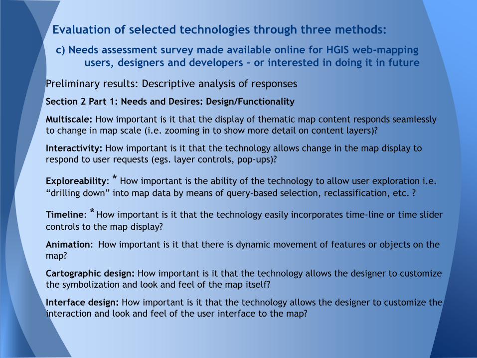
c) Needs assessment survey made available online for HGIS web-mapping
users, designers and developers – or interested in doing it in future
(Survey mounted online on May 2, 2016, and closed to responses on June 15, 2016)
Evaluation of selected technologies through three methods:
Survey adapted from:Roth, R.; Donohue, R.; Sack, C.; Wallace, T.; & Buckingham, T. (2014). A process for keeping pace with evolving web mapping technologies. Cartographic Perspectives, 78, 25-52.

c) Needs assessment survey made available online for HGIS web-mapping
users, designers and developers – or interested in doing it in future
Evaluation of selected technologies through three methods:
c) Needs assessment survey made available online for HGIS web-mapping
users, designers and developers – or interested in doing it in future
Evaluation of selected technologies through three methods:
Preliminary results: Descriptive analysis of responses
Section 2 Part 1: Needs and Desires: Design/Functionality
Multiscale: How important is it that the display of thematic map content responds seamlessly
to change in map scale (i.e. zooming in to show more detail on content layers)?
Interactivity: How important is it that the technology allows change in the map display to
respond to user requests (egs. layer controls, pop-ups)?
Exploreability: * How important is the ability of the technology to allow user exploration i.e.
“drilling down” into map data by means of query-based selection, reclassification, etc. ?
Timeline: * How important is it that the technology easily incorporates time-line or time slider
controls to the map display?
Animation: How important is it that there is dynamic movement of features or objects on the
map?
Cartographic design: How important is it that the technology allows the designer to customize
the symbolization and look and feel of the map itself?
Interface design: How important is it that the technology allows the designer to customize the
interaction and look and feel of the user interface to the map?

c) Needs assessment survey made available online for HGIS web-mapping
users, designers and developers – or interested in doing it in future
Evaluation of selected technologies through three methods: N
um
ber
of
resp
ondents
Preliminary results: Descriptive analysis of responses, frequency distribution
Expectations: All “important”
Goal: Look at unexpected
“Not”s or “Extremely”s and
use them to help understand
our stakeholders
* *Rating of
Characteristic
*
n = 50
Professor/teacher (12)
Student (7)
Librarian (13)
Researcher/analyst (14)
Commercial (4)

c) Needs assessment survey made available online for HGIS web-mapping
users, designers and developers – or interested in doing it in future
Evaluation of selected technologies through three methods:
Preliminary results: Descriptive analysis of responses, categorized by user group
* **

c) Needs assessment survey made available online for HGIS web-mapping
users, designers and developers – or interested in doing it in future
Evaluation of selected technologies through three methods:
Preliminary results: Descriptive analysis of responses, frequency distribution
*

c) Needs assessment survey made available online for HGIS web-mapping
users, designers and developers – or interested in doing it in future
Evaluation of selected technologies through three methods:
Preliminary results: Descriptive analysis of responses, categorized by user group
*

c) Needs assessment survey made available online for HGIS web-mapping
users, designers and developers – or interested in doing it in future
Evaluation of selected technologies through three methods:
Preliminary results: Descriptive analysis of responses, frequencies
* *

c) Needs assessment survey made available online for HGIS web-mapping
users, designers and developers – or interested in doing it in future
Evaluation of selected technologies through three methods:
Preliminary results: Descriptive analysis of responses, categorized by user group
* *

c) Needs assessment survey made available online for HGIS web-mapping
users, designers and developers – or interested in doing it in future
Evaluation of selected technologies through three methods:

c) Needs assessment survey Section 3: Experience using web-mapping
technologies: Descriptive analysis of responses, sorted by level of engagement
**
*

c) Needs assessment survey Section 3: Experience using web-mapping technologies:
Descriptive analysis of responses, sorted by level of engagement AND user group
*
*
*

c) Needs assessment survey Section 4: Future considerations for
historical web-mapping
Analysis
(informal)
of optional,
open ended
textual
questions,
looking for
insights and
trends

c) Needs assessment survey Section 4: Future considerations for historical web-
mapping
Analysis (informal) of open ended textual questions, looking for insights and trends
Examples: Summary by K. Roy and H. Wong
We are considering creating a "Historical web-mapping technology profiles" section on our project website, where different technologies would be described and reviewed, and users would be able to comment based on their own experience and make recommendations about usefulness or suggestions for improvements. Is this something that would interest you and to which you might contribute based on your own experience?
Response Rate (30/50) Is this something that would interest you and to which you might contribute..? Most respondents said yes and would find it useful/insightful (25) Some said maybe or that they would read but not contribute. (4) One user said it was not necessary/appropriate for this project, more important to focus on specific technologies/tools (1)
Selected interesting comments "I believe so. It is often that I find that I have never heard of a technology/tool that would have made my work better and easier. Having a place where I can browse and read about existing mapping technologies sounds great!"
"This would be useful. It might also be interesting to backwards engineer existing websites. "How did they do that" kind of posts."
"It would be useful to have a compiled list of various web-mapping technologies available to better understand their applications."
*

5. Next steps: Developing principles of practice and for Canadian
HGIS web-mapping activities, and plan to implement these in
our Partnership development pilot website
(Proposed) Principles of practice for Canadian HGIS Partnership
web-mapping activities
1. Support long-term sustainability and sharing of data and mapping
2. Support of visualization for both presentation purposes and data
exploration and analysis
3. Support transparency of the web-mapping process, through good
meta-data and documentation
4. Support of multiple platforms, both technical (OS, browsers) and
mapping (including proprietary and FOSS4G technologies)
5. Working collaboratively to avoid duplication of effort and
competition among current collaborators and potential partners
Whitepaper: Historical GIS visualization/web-mapping
*

5. Next steps: Developing principles of practice and for Canadian
HGIS web-mapping activities, and plan to implement these in
our Partnership development pilot website
(Proposed) CHGIS Partnership development web-mapping pilot
website activities
a. Analytical evaluation framework: A set of questions to consider
and evaluate in deciding on historical web-mapping approach and
technology - a checklist that will constitute a "visualization needs
analysis" for a specific historical GIS data set and use scenario
b. Historical web-mapping technology profiles: Standardized
descriptive comparison of technologies, incorporating "reviews“
c. Comparative examples of web-mapping approaches: Examples of
historical web-mapping projects using the same data and citing the
same goals but using contrasting technologies
Whitepaper: Historical GIS visualization/web-mapping

Next steps: Developing principles of practice and for Canadian
HGIS web-mapping activities, and plan to implement these in
our Partnership development pilot website
a. Analytical evaluation framework: A set of questions to consider
and evaluate in deciding on historical web-mapping approach and
technology - a checklist that will constitute a "visualization needs
analysis" for a specific historical GIS data set
The questionnaire or checklist would try to ascertain the following:
1. What are the stated communication goals for the webmap?
2. What is the target audience for the webmap?
3. What are the range of interaction options required for the webmap?
4. Given the above, what are the appropriate data to include for the webmap?
5. Given the above, what is the range of representation options for the webmaps?
6. Given all these, what is the range of technological options for the webmaps?
7. Can we come up with a list of “recommended” technology options?
Whitepaper: Historical GIS visualization/web-mapping

Whitepaper: Historical GIS visualization/web-mapping
Next steps: Developing principles of practice and for Canadian
HGIS web-mapping activities, and plan to implement these in
our Partnership development pilot website
b. Historical web-mapping technology profiles: Standardized
descriptive comparison of technologies, incorporating "reviews”
• The “Standardized descriptive comparison” of web-mapping technologies used to generate a set of historical web-mapping technology profiles
• Collaborators and partners who have expertise in many of these technologies, will help in completing these descriptions
• We also suggest a “technologies review” section, where people could post reviews, or comment on others’ opinions about technologies.
• This format has much in common with the work of the "GeoDirt" folks - the Geohumanities Special Interest Group of the Association of Digital Humanities Organizations (http://geohumanities.org/geodirt.) We have been in contact with them recently to see what collaboration can be established, and what resources shared

Next steps: Developing principles of practice and for Canadian
HGIS web-mapping activities, and plan to implement these in
our Partnership development pilot website
c. Comparative examples of web-mapping approaches: Examples of
historical webmapping projects using the same data and citing the
same goals but using contrasting technologies
i.e. take some "typical" sample sets of historical GIS project data,
enunciate specific goals for each of these in terms of the web-
mapping priorities we learned about in our users' needs survey, run
these through the analytical evaluation framework outlined above
(by way of illustrating that process) and then develop web-maps
and mount them online using several different technologies which
have been identified as likely candidates
Whitepaper: Historical GIS visualization/web-mapping

c. Comparative examples of web-mapping approaches: Examples of
historical webmapping projects using the same data and citing the
same goals but using contrasting technologies
Whitepaper: Historical GIS visualization/web-mapping
eg: Historical Atlas of
Canada Online
Learning Project
Map of population
Density by CD,
Time-Series data,
Growth of population
Using (for eg.):
• ArcGIS Online
• CartoDB
• Openlayers
• Others?

END
Geohistory-Géohistoire Canada:
Developing a partnership for
historical GIS and mapping in
Canada
October 20, 2016 NACIS conference
Byron Moldofsky
http://geohist.ca