Embed Size (px)
Citation preview

www.nt.gov.au
Geophysical programs to
support exploration under the
CORE initiativeTania Dhu, Manager Geophysics and Remote
Sensing
Northern Territory Geological Survey
15 September 2015DEPARTMENT OF PRIMARY INDUSTRY AND RESOURCES

www.nt.gov.au
• Maximise opportunities for the exploration, discovery and development of new mineral and petroleum resources
• Targeting the greater McArthur Basin, Arnhem Province, Arunta Region and Amadeus Basin
NTGS Regional Geoscience Programs
greater McArthur Basin
Arnhem Province
Amadeus Basin
Arunta Region
greater McArthur Basin Amadeus Basin
Arunta Region
Arnhem Province Palaeo-Mesoproterozoic Orogens
Archaean
Palaeo-Mesoproterozoic Basins
Mesozoic-Cenozoic
Neoproterozoic-Palaeozoic

www.nt.gov.au
• Understand the outcropping and undercover extent of the McArthur Basin and its stratigraphic correlatives in the BirrinduduBasin and Tomkinson Province
• Investigate basin architecture and evolution, copper ± base metal and hydrocarbon systems
• Programs include:
– Characterisation and correlation of stratigraphy
– Systematic hydrocarbon source rock analysis
– Acquisition of regional-scale geophysical data
– Construction of 3D geological models
Palaeo-Mesoproterozoic greater McArthur Basin
Carpentaria BasinBirrindudu Basin
McArthur Basin
Tomkinson Province
greater McArthur Basin Amadeus Basin
Arunta Region
Arnhem Province Palaeo-Mesoproterozoic Orogens
Archaean
Palaeo-Mesoproterozoic Basins
Mesozoic-Cenozoic
Neoproterozoic-Palaeozoic

www.nt.gov.au
• Framework studies to understand stratigraphic, structural, metamorphic and magmatic evolution and potential correlations with the highly prospective Pine Creek Orogen
• Programs include:
– 1:100k 1st edition geological maps and explanatory notes
Arnhem Province
Pine Creek OrogenMcArthur Basin
Arnhem Province
CarpentariaBasin
greater McArthur Basin Amadeus Basin
Arunta Region
Arnhem Province Palaeo-Mesoproterozoic Orogens
Archaean
Palaeo-Mesoproterozoic Basins
Mesozoic-Cenozoic
Neoproterozoic-Palaeozoic

www.nt.gov.au
Jervois (Cu-Pb-Zn)
• Framework studies to understand stratigraphic, structural, metamorphic and magmatic evolution of the Arunta Region
• Investigate resource potential of the Palaeoproterozoic Aileron Province
• Programs include:
– Characterisation of Cu ± polymetallicmineral systems
– 1:100k 1st edition maps and explanatory notes
Arunta Region
Clark (Cu)
Mount Hardy (Cu-Zn-Pb)
Rock Hill (Cu)
Home of Bullion (Cu-Zn-Pb-Ag-Au)
Strangways VHMS
Jericho (W-Cu-Ag-Pb-Zn)
Bonya (Cu)
Molyhil (W-Mo)
greater McArthur Basin Amadeus Basin
Arunta Region
Arnhem Province Palaeo-Mesoproterozoic Orogens
Archaean
Palaeo-Mesoproterozoic Basins
Mesozoic-Cenozoic
Neoproterozoic-Palaeozoic

www.nt.gov.au
• Understand basin architecture, evolution and resource potential
• Programs include:
– Neoproterozoic stratigraphic characterisation and correlation
– 1:100k and 1:250k geological maps and explanatory notes
– New regional scale gravity data
– CSIRO COBRA project (construct 3D model from potential field data; integrate geochemistry, sedimentology, isotopic analysis, ASTER to undertake resource assessment of the basin)
Amadeus Basin
Warumpi Province Arunta Region
Aileron Province
Eromanga Basin
Amadeus Basin
Musgrave Province
IrindinaProvince
greater McArthur Basin Amadeus Basin
Arunta Region
Arnhem Province Palaeo-Mesoproterozoic Orogens
Archaean
Palaeo-Mesoproterozoic Basins
Mesozoic-Cenozoic
Neoproterozoic-Palaeozoic

www.nt.gov.au
• Range of geophysical and remote
sensing projects:
– Improving pre-competitive
geophysical and remote sensing
datasets
– Interpretation and modelling of
new and existing data
– Integration of data and
construction of 3D models
Geophysics and Remote Sensing

www.nt.gov.au
• Increasing ground gravity resolution to 4 km
spacing or better
• Regional spacing – suitable for interpreting
regional-scale geology and basin architecture
• Prior to 2013 approximately 45% of NT
mainland covered by modern 4 km ground
spaced gravity
Ground Gravity Pre 2013 NT wide Bouguer anomaly (historical 11 km spaced data shaded)

www.nt.gov.au
Bouguer anomaly images of new surveys (historical 11 km spaced data shaded, pre-existing modern data faded)
• Six ground gravity surveys completed and one
currently underway
• NTGS has acquired over 20,000 gravity
stations
• Another ~8500 infill stations acquired by
industry
• Approximately 80% of NT mainland now
covered
Ground Gravity
West Amadeus
North McArthur Basin
South McArthur Basin
South WisoBasin
Victoria Basin
North WisoBasin
Daly Basin

www.nt.gov.au
Bouguer Anomaly (Pre 2013)
Bouguer Anomaly (Post 2013)
Daly Waters ArchDaly Waters Arch
Mallapunyah FaultMallapunyah Fault
Improves definition of regional scale structures
Beetaloo Sub-basin
Beetaloo Sub-basin
BeetalooSub-basin

www.nt.gov.au
• Increasing airborne magnetic and radiometric resolution to 500 m line spacing or better
• Prior to 2013 over 90% of NT mainland covered at this resolution
Airborne Magnetics and Radiometrics
Pre 2013 NT wide TMI RTP (historical data shaded)

www.nt.gov.au
• Two airborne magnetic and radiometric
surveys completed (3 areas)
• Over 200,000 line km of 400 m spaced
magnetic and radiometric data acquired
• Approximately 98% of the NT mainland now
covered
Airborne Magnetics and Radiometrics
Dunmarra
Delamere and Spirit Hills
TMI RTP images of new surveys (historical data shaded, pre-existing modern data faded)

www.nt.gov.au
Total Magnetic Intensity Reduced to Pole
Ternary Radiometrics
Dunmarra
Spirit Hills
Delamere
Dunmarra
Spirit Hills
Delamere

www.nt.gov.au
• PGN Geoscience contracted to provide a regional geophysical interpretation of gravity and magnetic data (DIP015):
– Spatial distribution of main sedimentary packages
– Structural development of the basins
– Fault timing and kinematics
• Produced prior to the North McArthur, North Wiso, Victoria Basin and Daly Basin gravity surveys and Dunmarra, Delamere and Spirit Hills magnetic and radiometric surveys
Gravity and Magnetic Interpretation
Syn-Glydepackage fault systems

www.nt.gov.au
• Collaboration between NTGS and CSIRO focussed on basin
architecture, base metal mineral systems and fluid flow within the
greater McArthur Basin
• Studies draw on CSIRO expertise in deformation, fluid flow and
reactive transport modelling, geophysical modelling and inversion,
mineral systems and exploration through cover
• Includes 2 CSIRO post-doctoral researchers (Teagan Blaikie and
Marcus Kunzmann) embedded within NTGS for three years
CSIRO Collaboration
greater McArthur Basin

www.nt.gov.au
• Build on PGN Geoscience project
through:
– Structural interpretation
– 2.75D forward modelling
– 3D inversion
• Constrained by known geology,
structure and rock properties
Gravity and Magnetic Interpretation using new data
Low pass (15,000 m), 1st vertical derivative of reduced to pole total magnetic intensity (top). Tilt derivative of Bougueranomaly derived from new gravity surveys acquired under the CORE initiative, overlain on the first vertical derivative of low pass filtered (8000 m) historical Bouguer anomaly grid (bottom).
Area of Interest
Magnetic Image
Gravity Image

www.nt.gov.au
Modelling Kalkarindji flood basalts
• Shallow basalts dominate magnetic expression in the Dunmarra Magnetic and Radiometric Survey
• Modelling of holes in sheet provide estimates of depth of ~270 m and thickness ~265 m (Foss and Dhu, 2016)
• Modelling of similar anomalies ~200 km apart produced comparable results

www.nt.gov.au
• Can Airborne Electromagnetic (AEM) systems
map the Barney Creek Formation:
– In what areas?
– At what depths?
– What is the best survey/system design?
• Analysis and interpretation of industry submitted
AEM data in the Batten Fault Zone (Ley-Cooper
et al 2011)
Batten Fault Zone
Teena (Zn-Pb)
McArthur River (Zn-Pb-Ag)
Batten Fault Zone AEM

www.nt.gov.au
• Over 40,000 line km of data
acquired using 7 different AEM
systems
• Data has been assessed for
suitability for full inversion or
approximate transformation to
estimate conductivity at depth
Batten Fault Zone AEM
Area of Interest
www.nt.gov.au
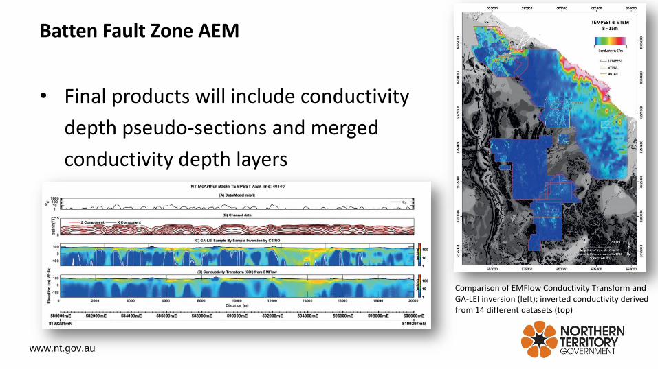
• Final products will include conductivity
depth pseudo-sections and merged
conductivity depth layers
Comparison of EMFlow Conductivity Transform and GA-LEI inversion (left); inverted conductivity derived from 14 different datasets (top)
Batten Fault Zone AEM

www.nt.gov.au
3D Modelling in the greater McArthur Basin
• Integrating disparate data in a 3D environment:
– Surface geology
– Geological cross-sections
– Balanced cross-sections
– Seismic interpretation
– Potential field interpretation
– Drillhole data
• Understanding the structural architecture, evolution and depth to prospective stratigraphy of the greater McArthur Basin at different scales
Large model extent
Higher resolution model extent

www.nt.gov.au
• Hyperspectral scanning of
drill core using the
HyLoggerTM instrument
• Rock property
measurements taken at
semi-regular intervals on
drill core
Hyperspectral

www.nt.gov.au
• Over 350 drillholes scanned, more than 100 km of drill core
• Summary reports for over 50 drillholes provided as Hylogger Data Packages (HDP)
Using HyLogger Data

www.nt.gov.au
• The Geophysics and Drilling Collaborations program has been running since 2008 providing co-funding assistance for drilling and geophysical projects
• A range of semi-regional or innovative surveys have been undertaken across the Northern Territory including
– ~54,000 ground gravity stations
– ~30,000 line km of airborne electromagnetic data
– ~1150 line km of sub-audio magnetic data
– ~400 audio magnetotelluric stations
– ~24,000 line km of airborne magnetic and radiometric data
– ~22 line km of seismic surveying
Geophysics and Drilling Collaborations

www.nt.gov.au
MagneticsGravity Radiometrics
Territory-wide geophysical products
www.nt.gov.au
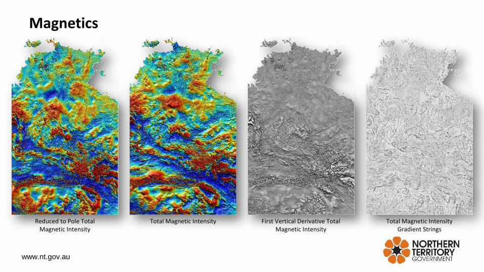
Magnetics
Reduced to Pole Total Magnetic Intensity
Total Magnetic Intensity First Vertical Derivative Total Magnetic Intensity
Total Magnetic Intensity Gradient Strings

www.nt.gov.au
• Geoscience Exploration and Mining Information System (GEMIS): http://geoscience.nt.gov.au/gemis– Digital Information Packages
• 3D Model (DIP012)
• Rock Properties (DIP013)
• PGN Geophysical Interpretation (DIP015)
• COBRA Project (DIP016)
– HyLogger Data Packages
– Geophysical Data – NT Wide Stitches, Individual Survey Data
– Industry submitted geophysical data (including GDC)
• STRIKE Tenure and Geoscience Information: http://strike.nt.gov.au– Spatial datasets
• Geophysical Image Web Server: http://geoscience.nt.gov.au/giws– Geophysical images
• Geophysical Archive Data Delivery System (GADDS): http://www.ga.gov.au/gadds– Geophysical data
Data Delivery

www.nt.gov.au
Thank you
References• Foss and Dhu, 2016. The bark without a dog – Magnetic Anomalies over Holes in a Volcanic Sheet in the greater McArthur
Basin, NT: in ‘Proceedings of the 25th Geophysical Conference.’ ASEG-PESA-AIG, Australia, Adelaide.• Ley-Cooper AY, Munday T, Ibrahimi T and Cahill K. Analysis and reinterpretation of historical AEM data sets: McArthur
Basin, NT: in Annual Geoscience Exploration Seminar (AGES) Proceedings, Alice Springs, Northern Territory 15-16 March 2016. Northern Territory Geological Survey, Darwin, 21-26.