Embed Size (px)
Citation preview
Preliminary Report on Possible Design Scenarios for Urban Agriculture and Food System Related Elements on San
Francisco Public Utilities Commission Land Within City Limits
Prepared by: Kevin Bayuk and Fred Bove, Instructors UC Berkeley Extension and Class Participants for Summer 2011
“Designing Sustainable Urban Food Systems” at UC Berkeley Extension
Prepared for: Francesca Vietor, President San Francisco Public Utilities Commission
SummaryIn early summer 2011 Kevin Bayuk attended two meetings with Francesca Vietor and staff at SF Public Utilities Commission (PUC), along with other representatives from the San Francisco Urban Agriculture Alliance (SFUAA), to solicit feedback from PUC on SFUAA's draft policy platform. In these meetings, SFUAA learned of SFPUC's intent to develop a Policy Framework for Community Benefits and Land Access regarding potential uses of PUC controlled public lands (what types of access are possible? what uses are possible? who gets access? Etc.) and the intent to develop a “pilot project” regarding urban agricultural use of PUC land. Kevin offered to support PUC in development of the Policy Framework by having his students at UC Berkeley Extension develop scenario planning for PUC sites already identified on the land audit completed by PUC pursuant to former Mayor Gavin Newsome's 2009 Executive Directive on Healthy and Sustainable Food. This report shares a summary of the scenario planning developed by the students of the UC Berkeley Extension Summer 2011 “Designing Sustainable Urban Food Systems” class in order to help assist PUC in developing an informed Policy Framework by describing feasible urban agriculture and food system uses of the following sites:
1. College Hill Reservoir
2. Sunset Reservoir
3. Sutro Reservoir
4. University Mound Reservoir
5. Central Pump Station/Merced Manor
6. Lake Merced Tract
7. Richmond Transport
8. Laguna Honda Reservoir
9. Stanford Heights Reservoir
10. Shafter and Fitch
These scenarios are not meant to be recommendations for use, but rather to inspire and inform land access policies about the potential uses. Should public access be considered for these sites, these scenarios could be used as starting points for collaborative design planning with local community groups, residents, SF PUC and other stakeholders. These site assessments and design scenarios are student work and are presented “as is”. Please forgive any formatting or grammar errors. High resolution images are available for any embedded image.
Contact for more information:Kevin [email protected]
Table of ContentsSummary....................................................................................................................................................2College Hill Reservoir...............................................................................................................................4
Assessment............................................................................................................................................4Scenarios...............................................................................................................................................8
Sunset Reservoir......................................................................................................................................12Assessment..........................................................................................................................................12Scenarios.............................................................................................................................................14
Sutro Reservoir........................................................................................................................................18Assessment..........................................................................................................................................18Scenarios.............................................................................................................................................21
University Mound Reservoir....................................................................................................................26Assessment..........................................................................................................................................26Scenarios.............................................................................................................................................27
Central Pump Station / Merced Manor....................................................................................................29Assessment..........................................................................................................................................29Scenarios.............................................................................................................................................30
Lake Merced Tract...................................................................................................................................34Assessment..........................................................................................................................................34Scenarios.............................................................................................................................................42
Richmond Transport.................................................................................................................................60Assessment .........................................................................................................................................60Scenarios.............................................................................................................................................62
Laguna Honda Reservoir.........................................................................................................................67Assessment..........................................................................................................................................67Scenarios.............................................................................................................................................68
Stanford Heights Reservoir......................................................................................................................70Assessment .........................................................................................................................................70Scenarios.............................................................................................................................................72
Shafter and Fitch......................................................................................................................................76Assessment..........................................................................................................................................76Scenarios.............................................................................................................................................77
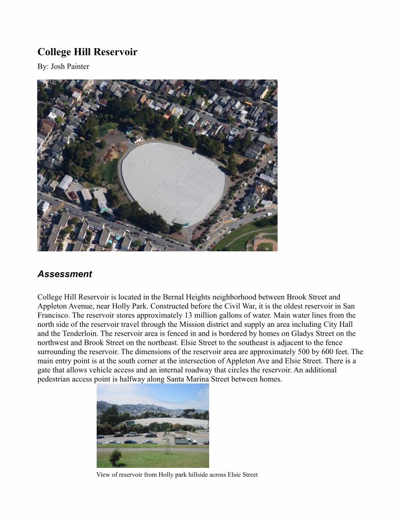
College Hill ReservoirBy: Josh Painter
Assessment
College Hill Reservoir is located in the Bernal Heights neighborhood between Brook Street and Appleton Avenue, near Holly Park. Constructed before the Civil War, it is the oldest reservoir in San Francisco. The reservoir stores approximately 13 million gallons of water. Main water lines from the north side of the reservoir travel through the Mission district and supply an area including City Hall and the Tenderloin. The reservoir area is fenced in and is bordered by homes on Gladys Street on the northwest and Brook Street on the northeast. Elsie Street to the southeast is adjacent to the fence surrounding the reservoir. The dimensions of the reservoir area are approximately 500 by 600 feet. The main entry point is at the south corner at the intersection of Appleton Ave and Elsie Street. There is a gate that allows vehicle access and an internal roadway that circles the reservoir. An additional pedestrian access point is halfway along Santa Marina Street between homes.
View of reservoir from Holly park hillside across Elsie Street
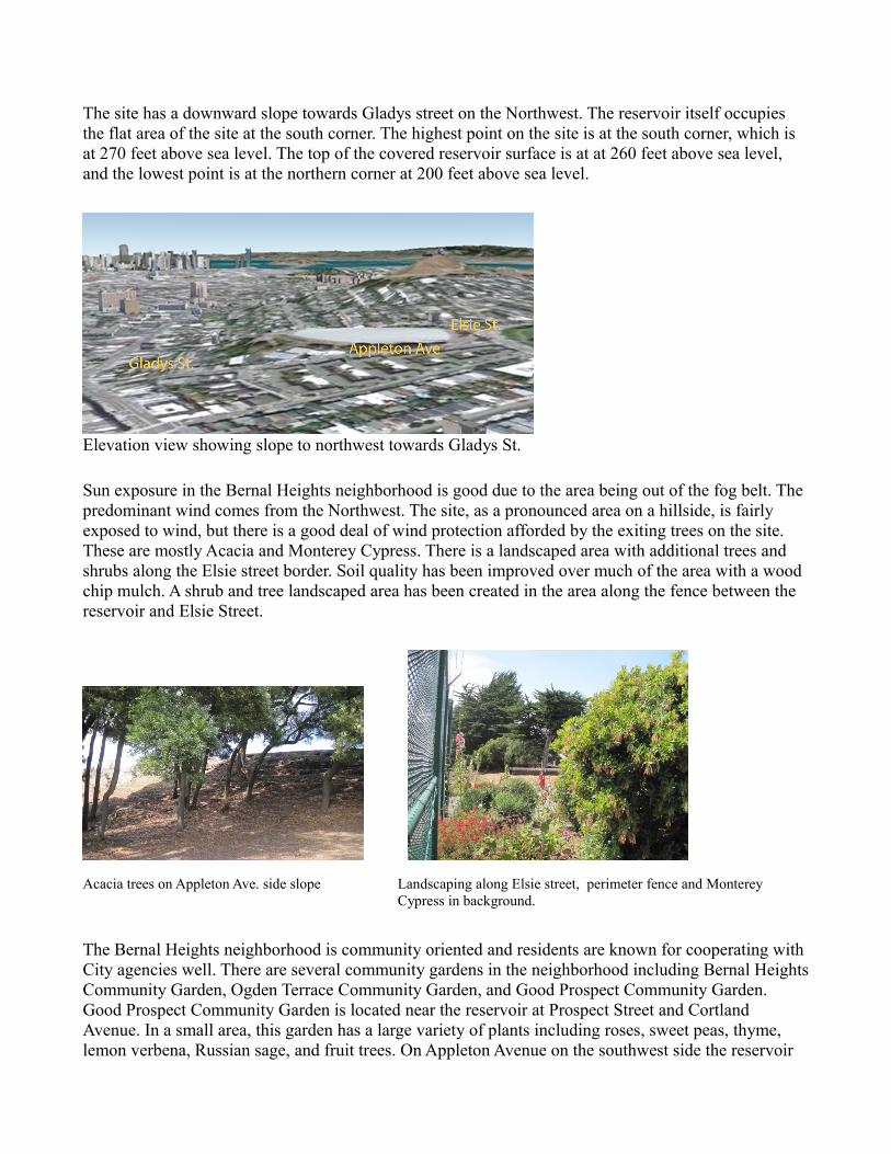
The site has a downward slope towards Gladys street on the Northwest. The reservoir itself occupies the flat area of the site at the south corner. The highest point on the site is at the south corner, which is at 270 feet above sea level. The top of the covered reservoir surface is at at 260 feet above sea level, and the lowest point is at the northern corner at 200 feet above sea level.
Elevation view showing slope to northwest towards Gladys St.
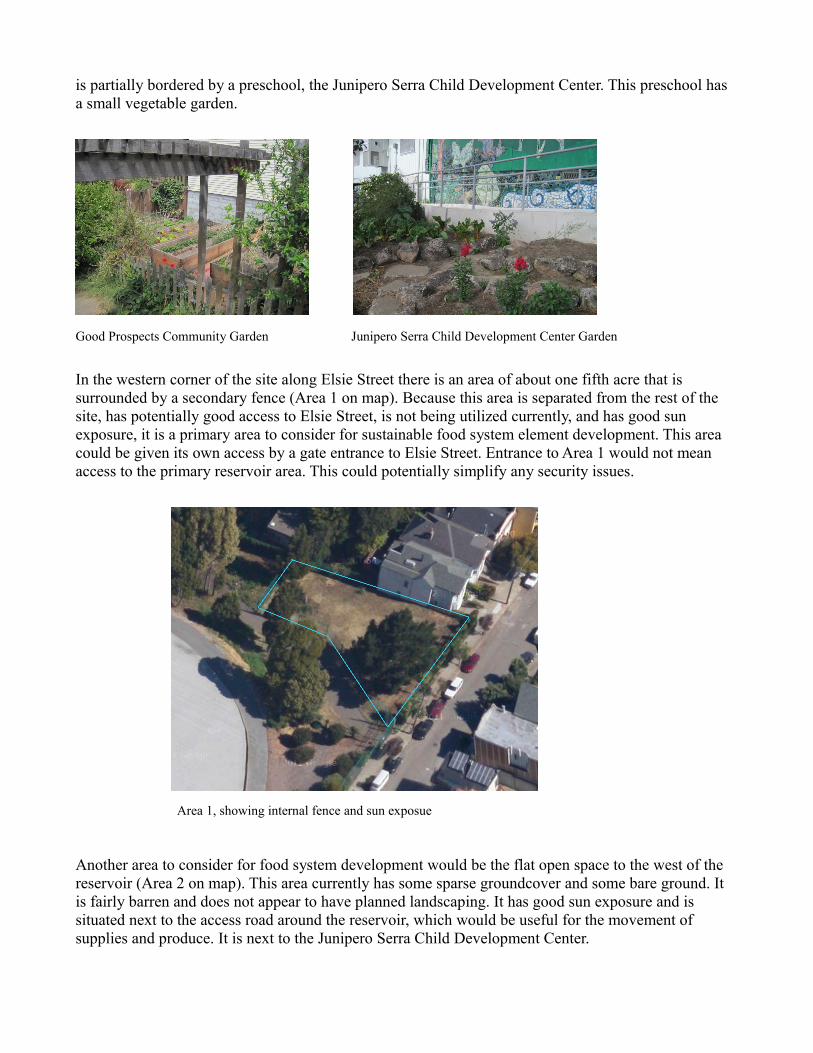
Sun exposure in the Bernal Heights neighborhood is good due to the area being out of the fog belt. The predominant wind comes from the Northwest. The site, as a pronounced area on a hillside, is fairly exposed to wind, but there is a good deal of wind protection afforded by the exiting trees on the site. These are mostly Acacia and Monterey Cypress. There is a landscaped area with additional trees and shrubs along the Elsie street border. Soil quality has been improved over much of the area with a wood chip mulch. A shrub and tree landscaped area has been created in the area along the fence between the reservoir and Elsie Street.
Acacia trees on Appleton Ave. side slope Landscaping along Elsie street, perimeter fence and Monterey
Cypress in background.
The Bernal Heights neighborhood is community oriented and residents are known for cooperating with City agencies well. There are several community gardens in the neighborhood including Bernal Heights Community Garden, Ogden Terrace Community Garden, and Good Prospect Community Garden. Good Prospect Community Garden is located near the reservoir at Prospect Street and Cortland Avenue. In a small area, this garden has a large variety of plants including roses, sweet peas, thyme, lemon verbena, Russian sage, and fruit trees. On Appleton Avenue on the southwest side the reservoir
is partially bordered by a preschool, the Junipero Serra Child Development Center. This preschool has a small vegetable garden.
Good Prospects Community Garden Junipero Serra Child Development Center Garden
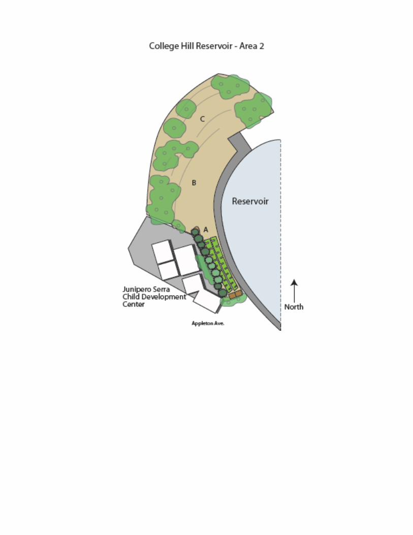
In the western corner of the site along Elsie Street there is an area of about one fifth acre that is surrounded by a secondary fence (Area 1 on map). Because this area is separated from the rest of the site, has potentially good access to Elsie Street, is not being utilized currently, and has good sun exposure, it is a primary area to consider for sustainable food system element development. This area could be given its own access by a gate entrance to Elsie Street. Entrance to Area 1 would not mean access to the primary reservoir area. This could potentially simplify any security issues.
Area 1, showing internal fence and sun exposue
Another area to consider for food system development would be the flat open space to the west of the reservoir (Area 2 on map). This area currently has some sparse groundcover and some bare ground. It is fairly barren and does not appear to have planned landscaping. It has good sun exposure and is situated next to the access road around the reservoir, which would be useful for the movement of supplies and produce. It is next to the Junipero Serra Child Development Center.
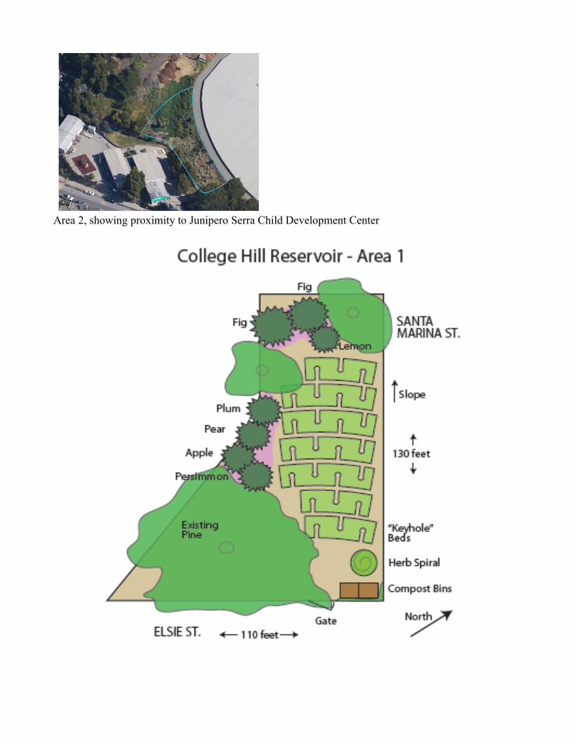
Area 2, showing proximity to Junipero Serra Child Development Center
ScenariosScenario 1: College Hill Reservoir Area 1: Community GardenThe internal fence that borders Area 1 would make it possible to give this area a separate gate and make access less restricted for users than would be for the main College Hill Reservoir area. It may be possible to have an unlocked gate. Because of its’ separation and its proximity to the Good Prospects Community Garden, it’s most natural role might be as a part of the neighborhood’s community garden system. The food produced by this garden could be distributed to the neighborhood, sold at a farmer’s market, or donated to a food bank.
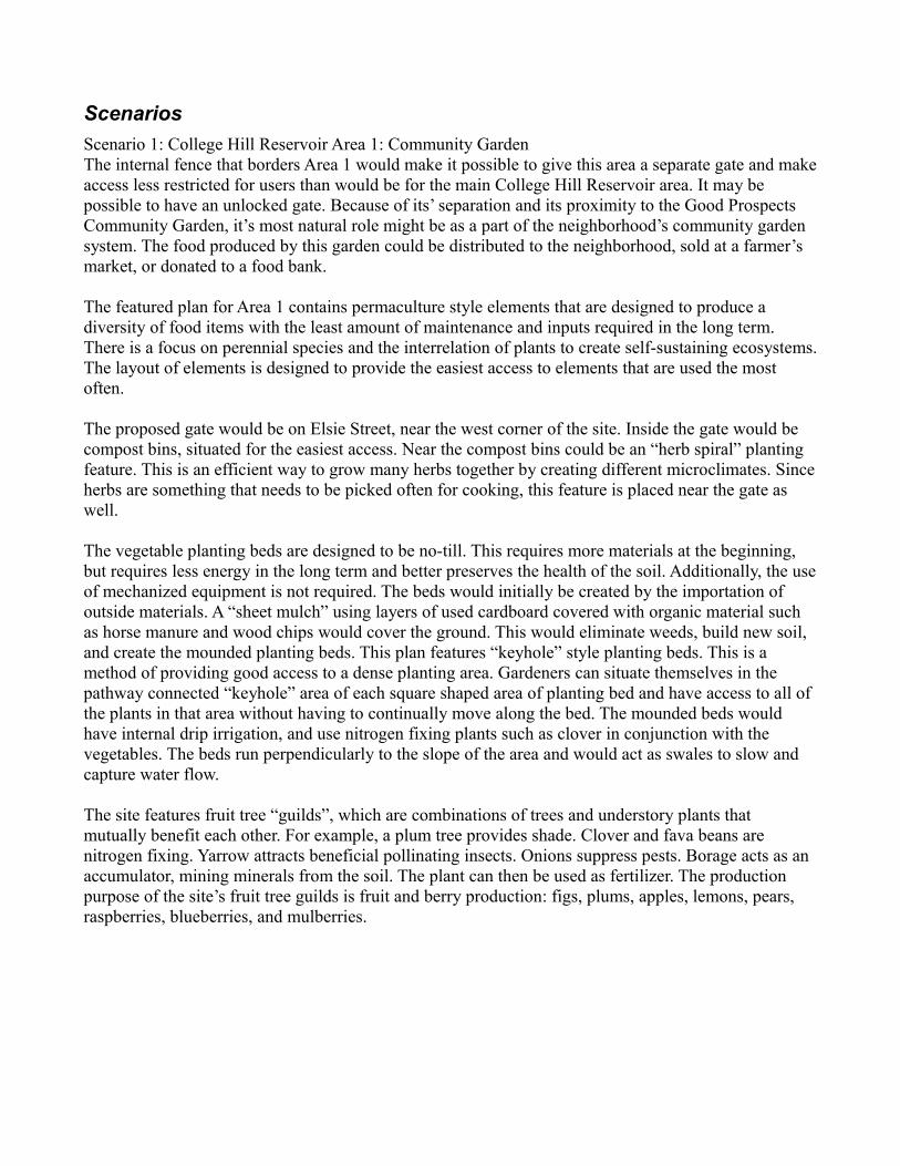
The featured plan for Area 1 contains permaculture style elements that are designed to produce a diversity of food items with the least amount of maintenance and inputs required in the long term. There is a focus on perennial species and the interrelation of plants to create self-sustaining ecosystems. The layout of elements is designed to provide the easiest access to elements that are used the most often.
The proposed gate would be on Elsie Street, near the west corner of the site. Inside the gate would be compost bins, situated for the easiest access. Near the compost bins could be an “herb spiral” planting feature. This is an efficient way to grow many herbs together by creating different microclimates. Since herbs are something that needs to be picked often for cooking, this feature is placed near the gate as well.
The vegetable planting beds are designed to be no-till. This requires more materials at the beginning, but requires less energy in the long term and better preserves the health of the soil. Additionally, the use of mechanized equipment is not required. The beds would initially be created by the importation of outside materials. A “sheet mulch” using layers of used cardboard covered with organic material such as horse manure and wood chips would cover the ground. This would eliminate weeds, build new soil, and create the mounded planting beds. This plan features “keyhole” style planting beds. This is a method of providing good access to a dense planting area. Gardeners can situate themselves in the pathway connected “keyhole” area of each square shaped area of planting bed and have access to all of the plants in that area without having to continually move along the bed. The mounded beds would have internal drip irrigation, and use nitrogen fixing plants such as clover in conjunction with the vegetables. The beds run perpendicularly to the slope of the area and would act as swales to slow and capture water flow.
The site features fruit tree “guilds”, which are combinations of trees and understory plants that mutually benefit each other. For example, a plum tree provides shade. Clover and fava beans are nitrogen fixing. Yarrow attracts beneficial pollinating insects. Onions suppress pests. Borage acts as an accumulator, mining minerals from the soil. The plant can then be used as fertilizer. The production purpose of the site’s fruit tree guilds is fruit and berry production: figs, plums, apples, lemons, pears, raspberries, blueberries, and mulberries.
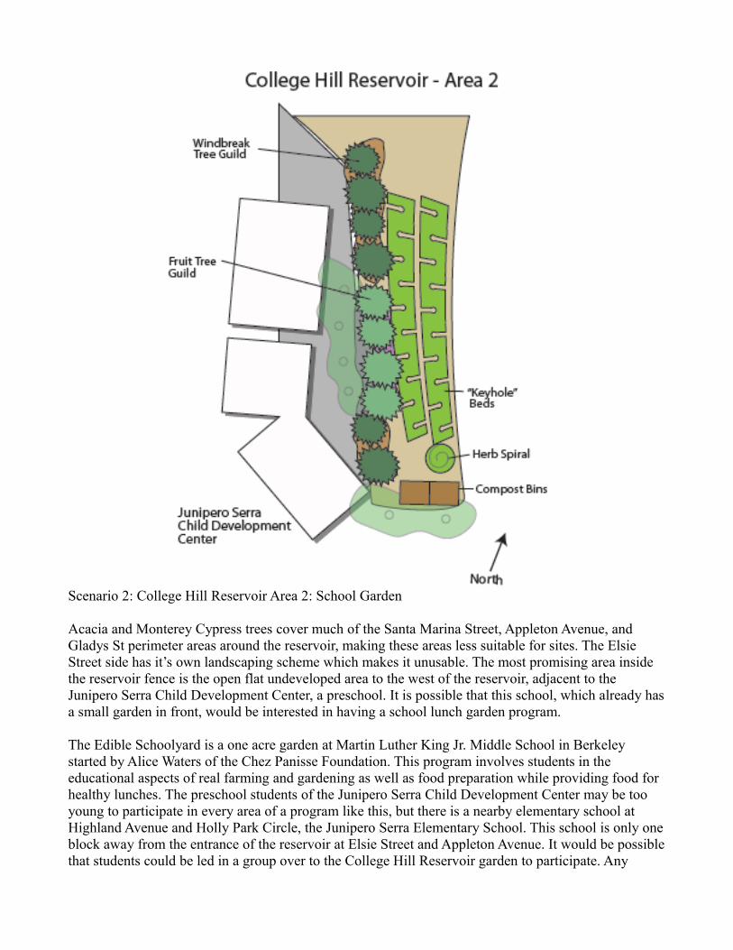
Scenario 2: College Hill Reservoir Area 2: School Garden
Acacia and Monterey Cypress trees cover much of the Santa Marina Street, Appleton Avenue, and Gladys St perimeter areas around the reservoir, making these areas less suitable for sites. The Elsie Street side has it’s own landscaping scheme which makes it unusable. The most promising area inside the reservoir fence is the open flat undeveloped area to the west of the reservoir, adjacent to the Junipero Serra Child Development Center, a preschool. It is possible that this school, which already has a small garden in front, would be interested in having a school lunch garden program.
The Edible Schoolyard is a one acre garden at Martin Luther King Jr. Middle School in Berkeley started by Alice Waters of the Chez Panisse Foundation. This program involves students in the educational aspects of real farming and gardening as well as food preparation while providing food for healthy lunches. The preschool students of the Junipero Serra Child Development Center may be too young to participate in every area of a program like this, but there is a nearby elementary school at Highland Avenue and Holly Park Circle, the Junipero Serra Elementary School. This school is only one block away from the entrance of the reservoir at Elsie Street and Appleton Avenue. It would be possible that students could be led in a group over to the College Hill Reservoir garden to participate. Any
potential security issues around the use of a garden area inside the reservoir perimeter fence could be made easier by the use of official school groups. Additionally, a secondary inside fence could be created to prevent users of the garden from entering the main reservoir area.
The plan proposes the development of the garden at the southern end of Area 2 (marked ‘A’ on the first map), due to its proximity to the school. Possibly a gate could be created for special school group use only. The flat area labeled ‘B’ is also promising as a potential extension to the initial area. The area labeled ‘C’ sloping and contains some trees, but may be suitable for a terraced orchard development.
The plan for Area 2 features most of the same elements as Area 1, but adds the element of a wind breaking tree guild, or hedgerow. The flat topography and top of the hill location indicate that this area would sustain a lot of wind. The hedgerow would protect the intensive annual beds from wind coming from the northwest. The space-efficient “keyhole” planting bed style is shown in the plan, but may not be needed due to the amount of space that is available in the northern direction of the site.
Aside from the use by the neighborhood school, other possible uses of this area as a sustainable food production site may include small scale local “market garden” commercial farming use community food center use.
Conclusion
Located in the center of a residential area that shows interest in community gardening, College Hill Reservoir has strong potential to become part of the production side of a local sustainable food system. Community connections can be made in this area to make the use of this site as a sustainable food production area a practical reality today.
Sunset ReservoirBy: Luke Suchy
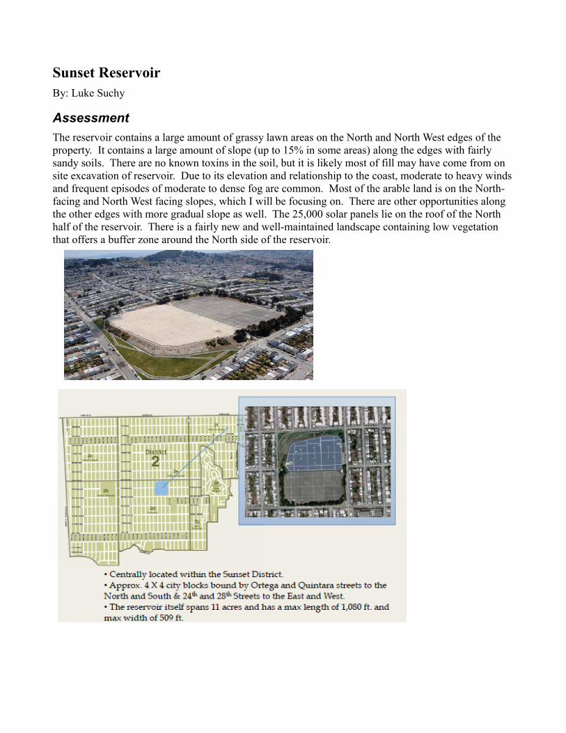
AssessmentThe reservoir contains a large amount of grassy lawn areas on the North and North West edges of the property. It contains a large amount of slope (up to 15% in some areas) along the edges with fairly sandy soils. There are no known toxins in the soil, but it is likely most of fill may have come from on site excavation of reservoir. Due to its elevation and relationship to the coast, moderate to heavy winds and frequent episodes of moderate to dense fog are common. Most of the arable land is on the North-facing and North West facing slopes, which I will be focusing on. There are other opportunities along the other edges with more gradual slope as well. The 25,000 solar panels lie on the roof of the North half of the reservoir. There is a fairly new and well-maintained landscape containing low vegetation that offers a buffer zone around the North side of the reservoir.
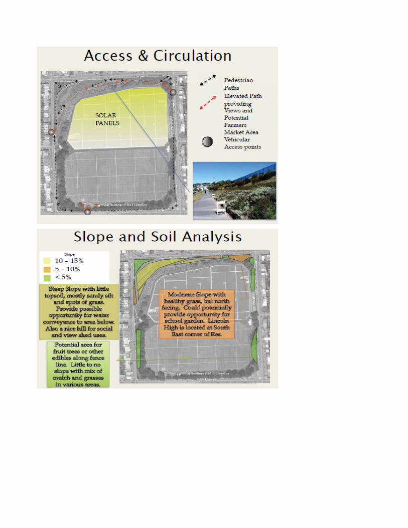
Scenarios
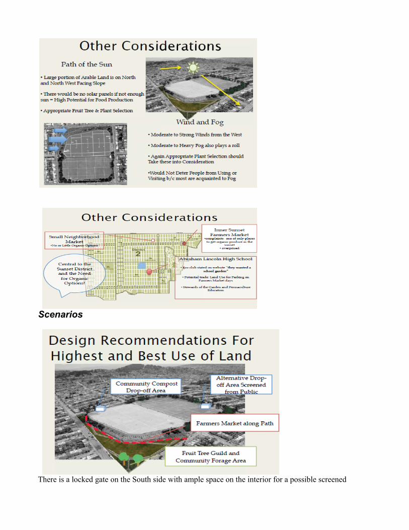
There is a locked gate on the South side with ample space on the interior for a possible screened
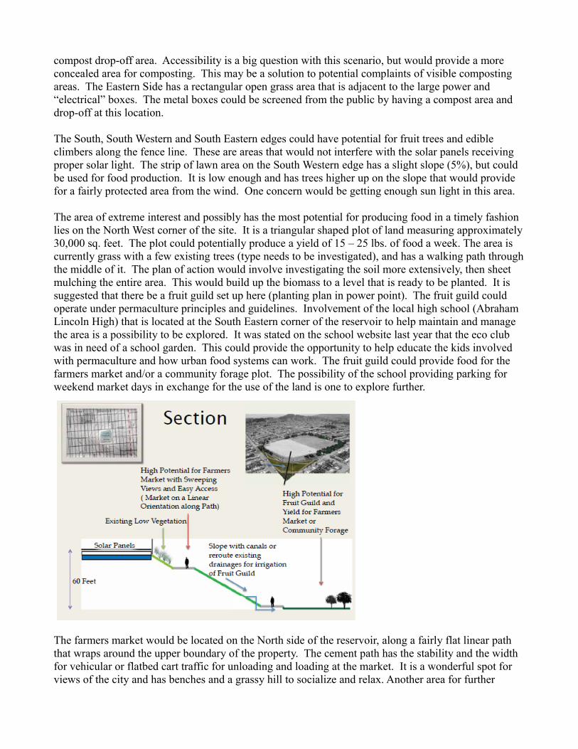
compost drop-off area. Accessibility is a big question with this scenario, but would provide a more concealed area for composting. This may be a solution to potential complaints of visible composting areas. The Eastern Side has a rectangular open grass area that is adjacent to the large power and “electrical” boxes. The metal boxes could be screened from the public by having a compost area and drop-off at this location.
The South, South Western and South Eastern edges could have potential for fruit trees and edible climbers along the fence line. These are areas that would not interfere with the solar panels receiving proper solar light. The strip of lawn area on the South Western edge has a slight slope (5%), but could be used for food production. It is low enough and has trees higher up on the slope that would provide for a fairly protected area from the wind. One concern would be getting enough sun light in this area.
The area of extreme interest and possibly has the most potential for producing food in a timely fashion lies on the North West corner of the site. It is a triangular shaped plot of land measuring approximately 30,000 sq. feet. The plot could potentially produce a yield of 15 – 25 lbs. of food a week. The area is currently grass with a few existing trees (type needs to be investigated), and has a walking path through the middle of it. The plan of action would involve investigating the soil more extensively, then sheet mulching the entire area. This would build up the biomass to a level that is ready to be planted. It is suggested that there be a fruit guild set up here (planting plan in power point). The fruit guild could operate under permaculture principles and guidelines. Involvement of the local high school (Abraham Lincoln High) that is located at the South Eastern corner of the reservoir to help maintain and manage the area is a possibility to be explored. It was stated on the school website last year that the eco club was in need of a school garden. This could provide the opportunity to help educate the kids involved with permaculture and how urban food systems can work. The fruit guild could provide food for the farmers market and/or a community forage plot. The possibility of the school providing parking for weekend market days in exchange for the use of the land is one to explore further.
The farmers market would be located on the North side of the reservoir, along a fairly flat linear path that wraps around the upper boundary of the property. The cement path has the stability and the width for vehicular or flatbed cart traffic for unloading and loading at the market. It is a wonderful spot for views of the city and has benches and a grassy hill to socialize and relax. Another area for further
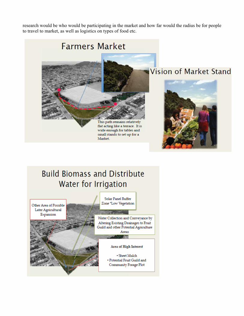
research would be who would be participating in the market and how far would the radius be for people to travel to market, as well as logistics on types of food etc.
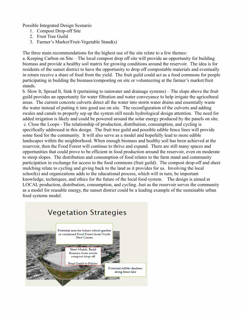
Possible Integrated Design Scenario 1. Compost Drop-off Site2. Fruit Tree Guild3. Farmer’s Market/Fruit-Vegetable Stand(s)
The three main recommendations for the highest use of the site relate to a few themes:a. Keeping Carbon on Site – The local compost drop off site will provide an opportunity for building biomass and provide a healthy soil matrix for growing conditions around the reservoir. The idea is for residents of the sunset district to have the opportunity to drop off compostable materials and eventually in return receive a share of food from the yield. The fruit guild could act as a food commons for people participating in building the biomass/composting on site or volunteering at the farmer’s market/fruit stands.b. Slow It, Spread It, Sink It (pertaining to rainwater and drainage systems) – The slope above the fruit guild provides an opportunity for water filtration and water conveyance to help irrigate the agricultural areas. The current concrete culverts direct all the water into storm water drains and essentially waste the water instead of putting it into good use on site. The reconfiguration of the culverts and adding swales and canals to properly sep up the system still needs hydrological design attention. The need for added irrigation is likely and could be powered around the solar energy produced by the panels on site. c. Close the Loops - The relationship of production, distribution, consumption, and cycling is specifically addressed in this design. The fruit tree guild and possible edible fence lines will provide some food for the community. It will also serve as a model and hopefully lead to more edible landscapes within the neighborhood. When enough biomass and healthy soil has been achieved at the reservoir, then the Food Forest will continue to thrive and expand. There are still many spaces and opportunities that could prove to be efficient in food production around the reservoir, even on moderate to steep slopes. The distribution and consumption of food relates to the farm stand and community participation in exchange for access to the food commons (fruit guild). The compost drop-off and sheet mulching relate to cycling and giving back to the land as it provides for us. Involving the local school(s) and organizations adds to the educational process, which will in turn, be important knowledge, techniques, and ethics for the future of the local food system. The design is aimed at LOCAL production, distribution, consumption, and cycling. Just as the reservoir serves the community as a model for reusable energy, the sunset district could be a leading example of the sustainable urban food systems model.
Sutro ReservoirBy: Natalie Forsyth
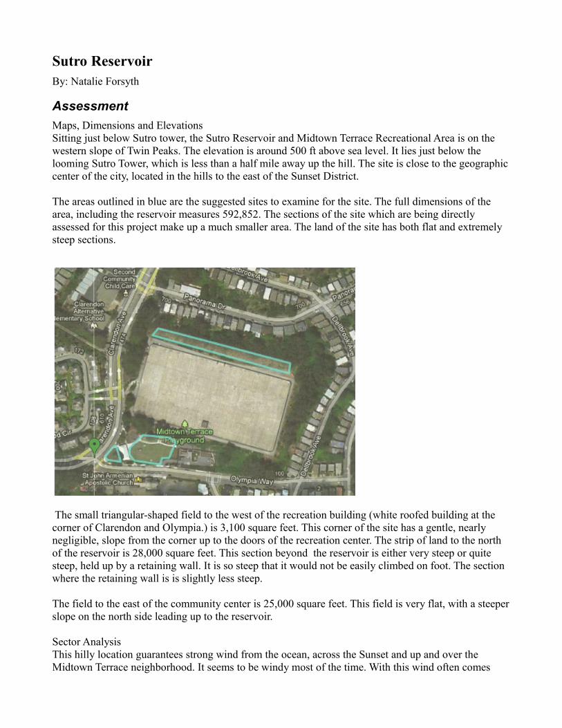
AssessmentMaps, Dimensions and ElevationsSitting just below Sutro tower, the Sutro Reservoir and Midtown Terrace Recreational Area is on the western slope of Twin Peaks. The elevation is around 500 ft above sea level. It lies just below the looming Sutro Tower, which is less than a half mile away up the hill. The site is close to the geographic center of the city, located in the hills to the east of the Sunset District.
The areas outlined in blue are the suggested sites to examine for the site. The full dimensions of the area, including the reservoir measures 592,852. The sections of the site which are being directly assessed for this project make up a much smaller area. The land of the site has both flat and extremely steep sections.
The small triangular-shaped field to the west of the recreation building (white roofed building at the corner of Clarendon and Olympia.) is 3,100 square feet. This corner of the site has a gentle, nearly negligible, slope from the corner up to the doors of the recreation center. The strip of land to the north of the reservoir is 28,000 square feet. This section beyond the reservoir is either very steep or quite steep, held up by a retaining wall. It is so steep that it would not be easily climbed on foot. The section where the retaining wall is is slightly less steep.
The field to the east of the community center is 25,000 square feet. This field is very flat, with a steeper slope on the north side leading up to the reservoir.
Sector AnalysisThis hilly location guarantees strong wind from the ocean, across the Sunset and up and over the Midtown Terrace neighborhood. It seems to be windy most of the time. With this wind often comes
fog. The fog, which roles around Sutro tower, is also constantly rolling over this site. During site visits throughout the summer months, the sun was never witnessed. The sun must emerge at times, but fog and wind are the predominant weather characteristics of the area.
People frequently interact with this land. Throughout the site visits, it became apparent how active this site is in the community, and how important it is for community purposes. It seems to be a place of recreation, with people playing with their children, their dogs and doing exercise. There are sections that are clearly not accessible to humans, such as the top of the reservoir, and the steep hills around the reservoir. These are clearly marked with fences and signage. Otherwise, the park is an open space for the community to engage with how they see fit.
Site History and Current Uses
The Sutro Reservoir was built in 1952 and holds 32 million gallons of water. It is a large space with around 300,000 square feet of rooftop covering the reservoir. The top of the reservoir used to be covered with tennis and basketball courts. When the top of the reservoir was redone (for siesmic stabilization) in 2006, they intended to put the courts back on top, but due to some design issue, has not yet been completed. Many community members miss this space. (Historical information gathered from
http://www.sutrotower.org/)
The Midtown Terrace Neighborhood Association The Midtown Terrace neighborhood was designed as a planned community in 1957. Characteristics of note about the neighborhood include the following:●All Midtown Terrace homes are separated and detached.●There are no homes built directly behind one another. All Midtown Terrace homes are separated by a strip of land called a green belt.●All telephone lines, power lines and utilities are located underground.●The 817 homes located in Midtown Terrace neighborhood are represented by a homeowners association dedicated to fostering better homes and better community life.(Statistics from Midtown Terrace Homeowner’s Association: http://www.midtownterrace.net/community.html)
The Sutro Reservoir site is a cornerstone of the community where people are consistently engaging with the space for many different purposes, including but not limited to:-All ages of children playing at the recently replaced park structure-Soccer and other children’s sport practice and general playing in the field to the east of the community center.-People walking their dogs around periphery of the park and using the paved walkways along the north and south sides of the reservoir to throw balls for their dogs to fetch.-Picnics on the field to the East of the Recreational Center.-Small children walking the stairs and pathways around the playground for exploring and going on adventures.-After school program as well as summer camp program at the Recreational Center.-Birthday parties at the Recreational Center, on the playground and on the field. Birthday parties often bring large inflatable “jumpy” houses, even pony rides.-Other social occasions when the community center is rented out, such as office parties.-Senior classes at the Recreational Center.-Basketball on the basketball courts.-Stretching and exercising around the reservoir. -Storing and preparing food for parties, camps, etc in the small kitchen in the Recreational Center.
Site AccessibilityThere are two roads which intersect at the suth-west corner of the site: Clarendon Avenue and Olympia Way. Clarendon Avenue is the main thoroughfare connecting Laguna Honda Blvd and the rest of the Sunset in the west to Cole Valley, the Upper Haight and the Panhandle of the city to the east. Clarendon Avenue is a steep and winding two to four lane road. This road seems to be traveled mostly by personal cars. No bicycles were observed. There is a bus line that goes through Midtown Terrace. It operates about every 20 minutes. It is the 36-Teresita (Forest Hill Station) line. Midtown Terrace is near the geographic center of the city, so it’s accessibility to all parts of the city is theoretically great, if somewhat car-bound. The site itself is readily accessible to foot traffic. Many people were observed walking from inside their neighborhoods to the site. Many people were also observed parking outside the recreation center, and then using the services of the recreation center and the park. There is a pedestrian bridge that crosses Clarendon Avenue just north of the site. It clearly connects the school (on the west side of Clarendon) with the site (on the east side of Clarendon.) This is important to note because of the in-place infrastructure that will continue to support this site as a community hub.
Once on the site itself, it is not readily accessible to vehicular traffic. There are no obvious roads on the site, and might require some infrastructural shift if it was necessary to bring in any sort of equipment to do work.
Nearby Neighborhood Groups and OrganizationsMidtown Terrace Homeowner’s AssociationBrian McDermottP.O. Box 31097San Francisco, CA 94131415.675.5864Email: [email protected] Group:http://groups.yahoo.com/group/midtownterrace
Clarendon Alternative Elementary School500 Clarendon AvenueSan Francisco, CA 94131-1113(415) 759-2796
Second Community Child CareCooperatively-run preschool with parents directly involved in the community.500 Clarendon AvenueSan Francisco, CA 94131-1113(415) 759-1897www.secondcommunity.org/
St. John Armenian Apostolic Church275 Olympia WaySan Francisco, CA 94131-1136(415) 661-1142stjohnarmenianchurch.com
Laguna Honda Hospital and Rehabilitation Center
375 Laguna HondaSan Francisco, CA 94127(415) 759-3333 (volunteers line)lagunahondavolunteers.org
San Francisco Fire Department StationOn Olympia at Clarendon.
ScenariosScenario: Community and Educational Garden:Community and Educational gardens are an important component to any sustainable urban food system. It engages the community with the food growing process. When children work in gardens, they learn where their food grows, how to care for the earth, and how to make the most responsible environmental decisions. Since the site is so heavily used by children, creating an educational garden is on obvious addition to the site. The garden could be placed on the field to the east of the Recreational Center. As the field is quite large (25,000 sq. ft), it could take up the far eastern section perhaps taking up as much as 5,000 ft. Reducing the current play area by 1/5th. This garden could have individual plots for people in the community to garden as they see fit. There could be 50 garden beds measuring 10 by 3 feet, taking up a total of 1,500 square feet in planting space, plus space needed for paths, etc. People could plant fog tolerant vegetables and flowers, artichokes and tree collards for example. As the area is so foggy, windy and cold, a green house would be a necessary part of the community garden. A comprehensive composting system would also be part of a well functioning garden space.
Yields:- education of community on gardening, cooking and food preservation.- individual yields of the community plots- 1,500 square feet of gardening space- 50 families gardening who would not be otherwise- increased community involvement and connection- increased awareness around food production
Questions:-What is current irrigation infrastructure?-Who would be the organizing group?-Could netting or other barrier (fruit trees?) be put up between the play field and the garden? (So that balls would not constantly go into the garden.)-What would be the best material for the green house? (for warmth, as well as strength- in case of errant balls)-Would it be worth using the space for this in terms of sunlight-fog ratio?
Scenario: Farmer’s Market
Farmer’s markets allow neighborhoods to shop for nutritious whole food close to home. They allow farmer’s to sell their food in a consistent way. Relationships develop between farmers and community members. The farmer’s market becomes a gathering place for the community.
A small scale farmer’s market with about 10 vendors would be appropriate for this site- including vendors who sell vitamin and mineral rich perishable fruits and vegetables, eggs, dairy and meat, as
well as other food items such as bread, grains and nuts. On this site, the market would work well as an afternoon week day market. Many people already frequent the area making use of the playground, after school programs and sports practices. It could become a consistent part of the communities routine, supplying them with fresh, nutritious food and enriching community life. The market could be on the far southwest triangular corner of the site, where Clarendon and Olympia Way meet. As this would be only one afternoon a week, the area would be free for usual uses for most of the week.
Yields:-ability for community to buy nutritious, whole food within neighborhood (there are currently no grocery stores within the neighborhood.-greater opportunity for community development-greater percentage of communities money going to local food sources, rather than large super market chains-education of children and community members about the importance of a local, decentralized food system-income for farms participating in market-more time for community members to be with family, not shopping farther from home
Questions:-What sort of community outreach would need to happen to make a farmer’s market successful?
Scenario: Demonstration Fog Collection Area
Technology on fog collection is currently advancing with some real success stories throughout arid regions of the world. These systems work by placing “fog fences” in the path of the fog. The fog then condenses on the fences and drips down into a collection barrel. “Larger fog collectors of approximately 40 square meters, which can produce 200 liters per day, can be set up for $1000 to $1500 each. The system is completely passive, requires no energy inputs, and can last ten years provided it’s taken care of.” Summer in San Francisco is notoriously foggy. The summer months are also generally rain-free. The ability for the San Francisco peninsula to accumulate water during the dry,but foggy, months would be a great step in being water-independent. The western slope of Twin Peaks, which is often totally socked in with fog, would be a perfect location for a test demonstration site of fog collection. With the large and constant circulation of community members around the site, it is a great opportunity to not only collect water, but also to educate the community members on water conservation and collection. The best location on the site for fog collectors is perhaps on the back retaining wall on the far north side of the site. Could also perhaps be on top of the reservoir, or on the far east side of the reservoir. Could also be placed on the eastern edge of the community garden, allowing the immediate utilization of the water collection as irrigation in the garden.
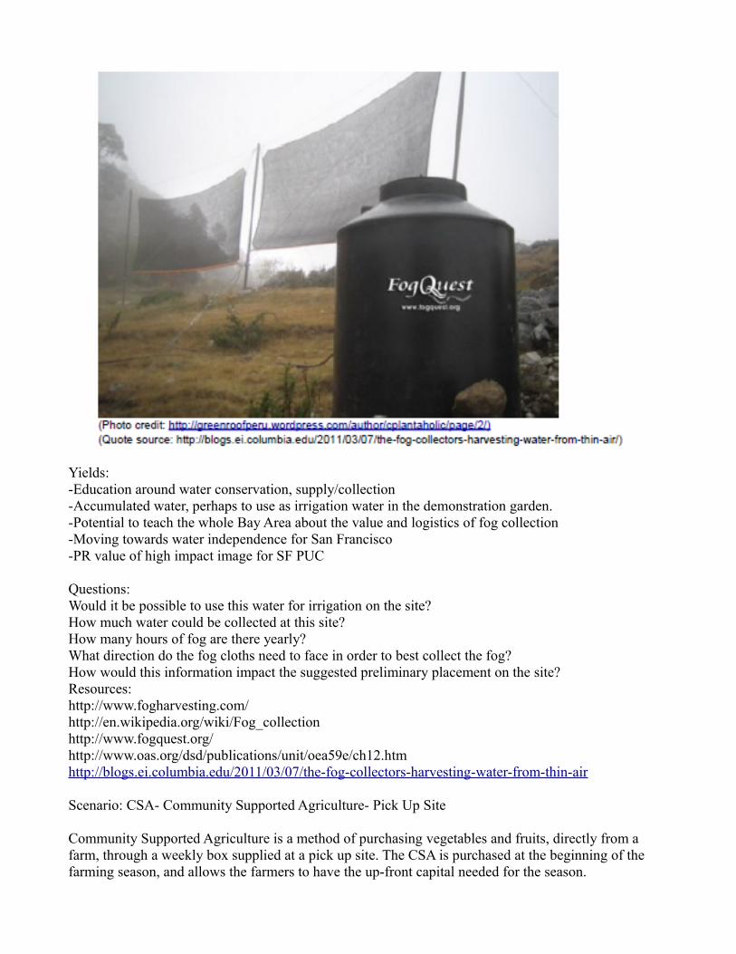
Yields:-Education around water conservation, supply/collection-Accumulated water, perhaps to use as irrigation water in the demonstration garden.-Potential to teach the whole Bay Area about the value and logistics of fog collection-Moving towards water independence for San Francisco-PR value of high impact image for SF PUC
Questions:Would it be possible to use this water for irrigation on the site?How much water could be collected at this site?How many hours of fog are there yearly?What direction do the fog cloths need to face in order to best collect the fog?How would this information impact the suggested preliminary placement on the site?Resources:http://www.fogharvesting.com/http://en.wikipedia.org/wiki/Fog_collectionhttp://www.fogquest.org/http://www.oas.org/dsd/publications/unit/oea59e/ch12.htmhttp://blogs.ei.columbia.edu/2011/03/07/the-fog-collectors-harvesting-water-from-thin-air
Scenario: CSA- Community Supported Agriculture- Pick Up Site
Community Supported Agriculture is a method of purchasing vegetables and fruits, directly from a farm, through a weekly box supplied at a pick up site. The CSA is purchased at the beginning of the farming season, and allows the farmers to have the up-front capital needed for the season.
If one farm could supply the community of Midtown Terrace with a CSA delivered to the site, then dozens of homes would receive all the vegetables and most of the fruit that the families would need for the week by simply dropping by the neighborhood playground. Having a farm in the peri-urban that the neighborhood supported would create more community connection.
Yields:-Healthy nutritious food reaching the community on a weekly basis without having to travel out of the neighborhood-Greater community involvement, a whole neighborhood supporting one farm
Resources:http://www.wilson.edu/about-wilson-college/fulton/robyn-van-en-center/index.aspxhttp://www.csafarms.org/csafarms0656231.asphttp://www.ecovian.com/s/sanfrancisco/csahttp://nuttyfig.com/2011/03/starting-a-successful-csa-tips-from-the-calif-small-farm-conference/
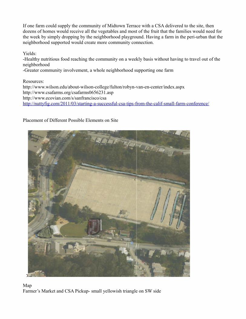
Placement of Different Possible Elements on Site
MapFarmer’s Market and CSA Pickup- small yellowish triangle on SW side
Community and Demonstration Garden- small red section in the fieldFog collectors- blue lines on far north side and on reservoir itself.
Possible Integrated Vision for the Site
The primary goal for using this site as a component of the San Francisco sustainable food system will be to bring greater awareness and action around the food system to the Midtown Terrace community, including over 800 homes. This site is already at the center of the neighborhood, with community members using the site daily. With a shift in the focus of the land purpose and use, the whole neighborhood can become more empowered and enlivened to engage with a sustainable food system directly inside their own community.
Production Elements:-Educational garden, including community plots and greenhouse, chickens and geese-Hardy fruit trees planted throughout area on gentle slopes-Hands-on educational programming on gardening, from seed saving to food production
Distribution Elements:-Micro Farmer’s Market, including fresh fruits and veggies, grains, nuts and seeds, eggs, dairy and meat-CSA pick-up site, possibly an egg CSA from the chickens on the site-Educational opportunities at Farmer’s Market about why local, decentralized food systems are important
Consumption Elements:-Snacks for after school program provided by garden and orchard trees, when possible-After school program food also supplied by micro-farmer’s market, or perhaps CSA-Community garden plot yields consumed in private homes-Hands-on educational programming on cooking, food preservation and nutrition in commercial kitchen in the recreation center
Cycling Elements:-Composting system, possibly vermiculture, taking all compostables from garden and from recreation center, near greenhouse, taking advantage of thermal and wind block-Grey-water and black-water recycling in the recreation center, used as fertilizers-Fog collection site, used to irrigate garden and educate community-Educational programming on water conservation, purification and composting
By incorporating different elements from each of the stages of the food system, this design for the site at Midtown Terrace, guarantees an expanding positive interaction between the community and the food system. Emphasizing community involvement throughout the design is necessary for this site, as it is already hugely utilized by the community. There are already many students and children who use the site daily. By shifting land use, the children will still be learning and playing, with the food system at the center of their activities. Children are an essential element in helping their parents make transitions.Through the stacking of functions, as well as maximizing the input and output to each of the elements, this design has the potential to create a comprehensive plan that will be able to serve the community through education, community growth, food production and distribution.
University Mound ReservoirBy: Tim Ryan
Assessment1. Orientation - The site is rectangular in shape, the longest side(s) is parallel to a
south/southeast-north/ northwest axis2. Street Boarder(s) - University St. (west-side), Felton St. (north-side), Bowdoin St. (east-side)
and Woosley St. (south-side). Bacon St. bisects the property on an east/northeast- west/southwest axis, (currently it is closed to the public but scheduled to reopen)
3. Elevation changes - The roof of each reservoir is the highest & flattest area on the site, the planted area(s) descend at different slopes from the reservoir toward the street(s). The greatest change in elevation is on the Southeast corner.
4. Wind/Surrounding Terrain - the Northern side is the most exposed to winds, as it is located near the break in the mountains running north along the peninsula (I-280 runs through this corridor). The rest of the site is somewhat protected by hills rising to an elevation of nearly 500’ which wrap around the Southwest corner. This elevated feature is important also to the drainage around the site. The southwest corner of the site is located near the base of a valley which funnels rainwater run-off toward the reservoir.
5. Area with Existing Plantings - The majority is located on the southern & eastern edge(s) of the rectangle with a small strip on the northern side of the property.
6. Existing Trees - Within the property are mostly Cupressa macrocarpa- “Monterey Cypress” and along the street Arbutus marina “Strawberry Tree”
7. Structures/Paved areas - The reservoir(s) occupy the majority of the site. In the north section are maintenance sheds & storage, a pumping station and parking lot. In the south section are several small maintenance sheds. There is a two-story house on the corner of University & Bacon St. with a small garden enclosed by the fence, which also surround the reservoir.
8. Access - An area on the northern side is the only section that is not fenced off. There is a staircase located near the pumping station on Felton St. This area is terraced with two retaining walls.
9. Fencing - most of the property is surrounded by a +10’ high chain-link fence.
Surrounding Neighborhood(s)1. Parks
a. John McLaren Park, specifically the Louis Sutter Playground, is adjacent to the property of the southwest corner.
b. Palega-Portola Recreation Center is one block east on Felton St.2. Schools within a 5-10min walk
a. St. Elizabeth’sb. Edward R Taylor Elementaryc. Martin Luther King Middled. Phillip & Sala Burton Academic Highe. Hillcrest Elementaryf. Cornerstone Academy (2 locations)
3. Other Organizations a. University Mound Ladies Homes is an assisted living center adjacent to the property
at University St. & Bacon St.4. Unused/ Abandon Property
a. Greenhouse adjacent to the property at Bowdoin St. & Woolsey St.Questions about the site
1. Granting access to fenced areas (excluding the roof of the reservoirs)a. Could student groups be allowed to farm the site under the guidance of teachers
during designated hours?2. Is the house on the corner of University and Bacon St. used/owned by the PUC or is it a
private residence. Could it be used as to store gardening tools, distribution of food, as a teaching center and/or a residence for an on-site care taker(s)?
3. Would the PUC be will (in the future) to re-position the fence surrounding the southern reservoir to allow access to the planted area?
Scenarios1. Immediate use of the north side to create a teaching garden for local schools
a. Create a wind break using fruiting trees which will eventually replace aging Cypress and Eucalyptus trees
b. Use those trees (as they are removed) for construction timbers and/or mulch on or off-site. Timber could also be sold to local artisans as a raw material.
c. Create smaller terraces to make plant-able areas easier to access2. Begin outreach to local schools, the Rec. center and the University Mound Ladies Home for
participants as wells Non-profit organizations focusing on a. Grant students, supervised by teachers/ instructors, scheduled access to southern section
to begin farming existing soils.b. Students may use time on site toward community service hoursc. Programs matching students with the elderly
3. Fences as support for climbing edible plants a. Structures are already in placeb. Use of several varieties of climbersc. Plants will a an aesthetic quality to the site, softening the harsh feel and look of the
chain-link4. Installation of Solar Panels, based on results of the Sunset Reservoir Solar project
a. This site is larger and more than likely experiences more sun exposure than the Sunset location
5. Rainwater collection-Based on the surrounding topography a. Construct rain gardens where the street(s) meets the curb edge to capture and clean
street run-off. These would be best located on the south and west sides of the site. (this system can daylight the historic location of a creek that flowed toward the Yosemite slough)AND/OR
b. Construct rain gardens at the edges of the reservoirs to collect and clean reservoir run-off. These would be best located on the south and north sides of the site
c. These rain gardens could catch the “1st flush” and allow the overflow to collect in basins to provide irrigation to the on-site gardens.
6. Create an orchard a. The southern section of the site can support a large number of trees.b. Fruiting trees could begin to replace existing/aging trees, c. An orchard would need less daily maintenance than a vegetable garden requiring fewer
visits to fenced/ secured areas on the sited. Trees selected for the orchard should bear fruit/nuts during various times of the year to
spread the yield and work load.7. An education center/ Teaching Kitchen
a. The yellow house on University & Bacon could be used to prepare meals using food grown on site
b. If there is an existing kitchen small groups of students could attend classes on preparation methods and nutrition related to the foods grown on site.
8. Transformation of Bowdoin St. a. This street could be easily closed on a temporary basis or permanently to host a farmers’
market or small festivalb. Food from the site’s garden as well as off site farms could be sold here.c. This street could also become an extension of plant-able space by building soil on top of
existing road surface.d. As the area is unfenced, admission would require a lower level of supervision.
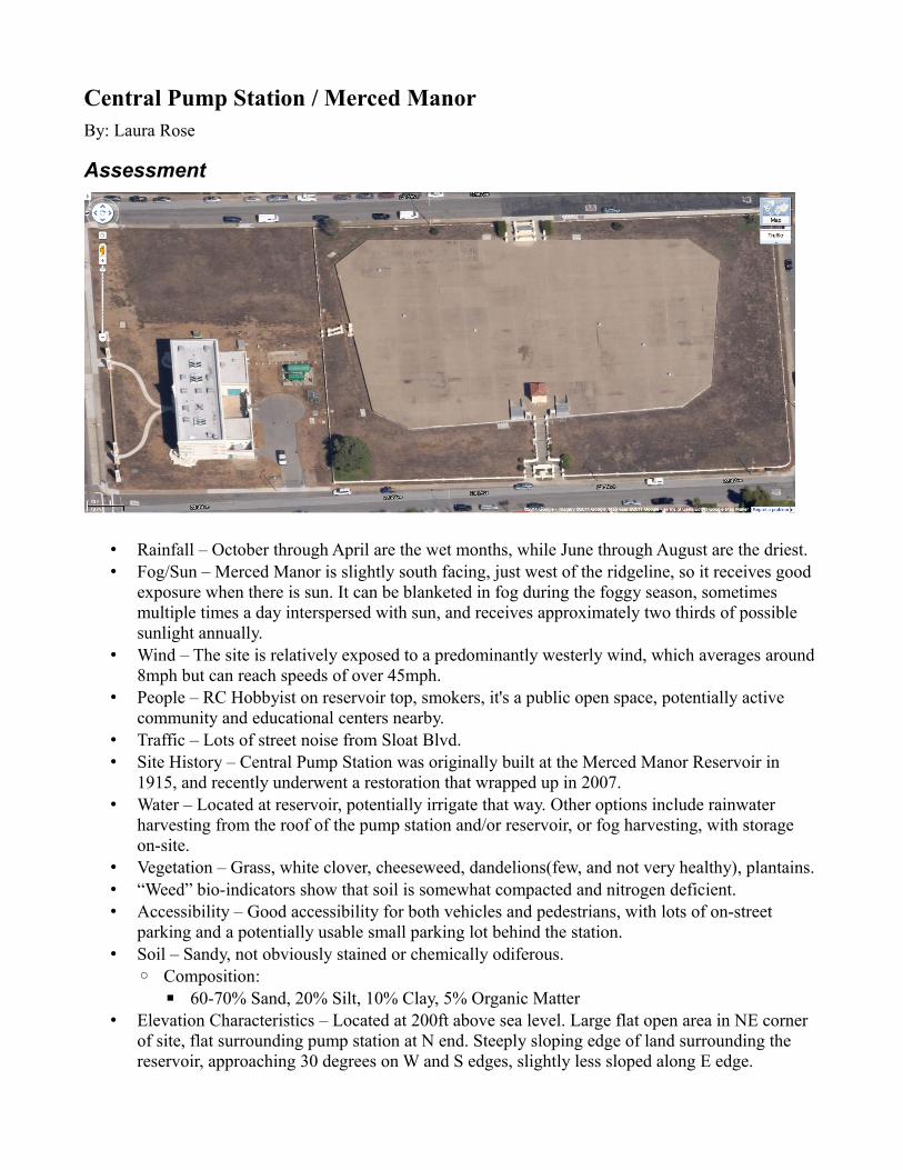
Central Pump Station / Merced ManorBy: Laura Rose
Assessment
• Rainfall – October through April are the wet months, while June through August are the driest.• Fog/Sun – Merced Manor is slightly south facing, just west of the ridgeline, so it receives good
exposure when there is sun. It can be blanketed in fog during the foggy season, sometimes multiple times a day interspersed with sun, and receives approximately two thirds of possible sunlight annually.
• Wind – The site is relatively exposed to a predominantly westerly wind, which averages around 8mph but can reach speeds of over 45mph.
• People – RC Hobbyist on reservoir top, smokers, it's a public open space, potentially active community and educational centers nearby.
• Traffic – Lots of street noise from Sloat Blvd.• Site History – Central Pump Station was originally built at the Merced Manor Reservoir in
1915, and recently underwent a restoration that wrapped up in 2007.• Water – Located at reservoir, potentially irrigate that way. Other options include rainwater
harvesting from the roof of the pump station and/or reservoir, or fog harvesting, with storage on-site.
• Vegetation – Grass, white clover, cheeseweed, dandelions(few, and not very healthy), plantains.• “Weed” bio-indicators show that soil is somewhat compacted and nitrogen deficient.• Accessibility – Good accessibility for both vehicles and pedestrians, with lots of on-street
parking and a potentially usable small parking lot behind the station.• Soil – Sandy, not obviously stained or chemically odiferous.
◦ Composition:▪ 60-70% Sand, 20% Silt, 10% Clay, 5% Organic Matter
• Elevation Characteristics – Located at 200ft above sea level. Large flat open area in NE corner of site, flat surrounding pump station at N end. Steeply sloping edge of land surrounding the reservoir, approaching 30 degrees on W and S edges, slightly less sloped along E edge.
Local/Community Organizations of Interest• San Francisco State University (Sustainability Committee or Friends of the Greenhouse?)• Lowell High School• Lakeshore Alternative Elementary• The Urban Farmer Store (not a community organization, but close by and may be interested in
involvement)
Risks/Unknowns• Water access for irrigation• Security concerns regarding reservoir• Community involvement• Costs
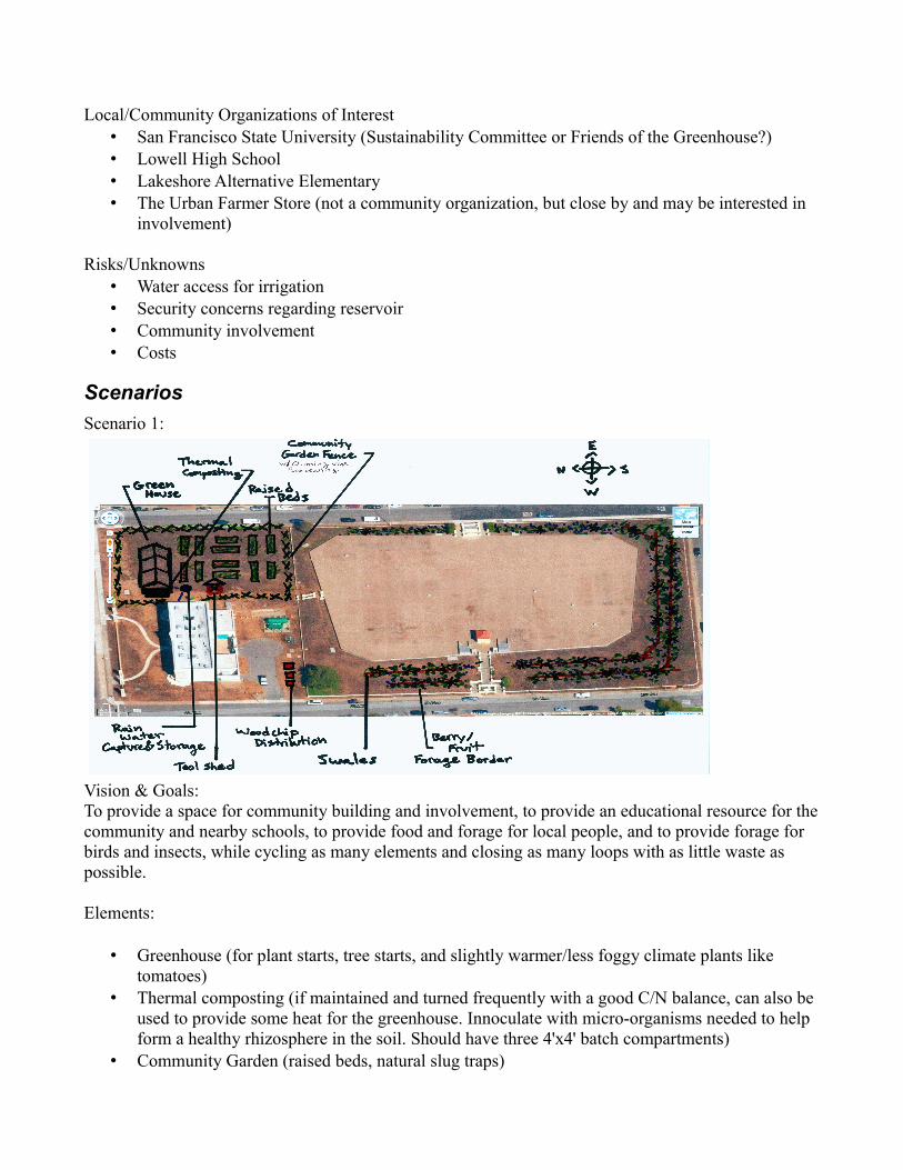
ScenariosScenario 1:
Vision & Goals:To provide a space for community building and involvement, to provide an educational resource for the community and nearby schools, to provide food and forage for local people, and to provide forage for birds and insects, while cycling as many elements and closing as many loops with as little waste as possible.
Elements:
• Greenhouse (for plant starts, tree starts, and slightly warmer/less foggy climate plants like tomatoes)
• Thermal composting (if maintained and turned frequently with a good C/N balance, can also be used to provide some heat for the greenhouse. Innoculate with micro-organisms needed to help form a healthy rhizosphere in the soil. Should have three 4'x4' batch compartments)
• Community Garden (raised beds, natural slug traps)
• Tool shed• Berry/Fruit polycultural forage border (interplanted apple, plum, linden, blackberry, comfrey,
fava beans, olallieberry, nasturtium, mint, etc, planted on slopes wrapping around reservoir, possibly on a couple of swales on contour dug/piled in)
• Woodchip Distribution node • Rainwater Harvesting & Storage (from the roof of the central pump station building, and
possibly the greenhouse roof)
Estimated Yields:• Increased community awareness of issues surrounding urban food systems and healthy and
complete human nutrition.• Increased community access to educational and material resources related to a sustainable food
system.• Mulch, compost inputs, and finished compost• Thousands of pounds of fruits & vegetables per year, depending on community garden crops.• Bird & insect forage
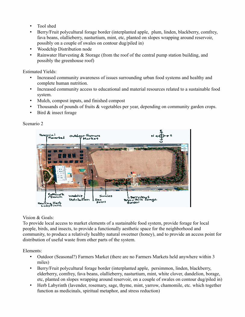
Scenario 2
Vision & Goals:To provide local access to market elements of a sustainable food system, provide forage for local people, birds, and insects, to provide a functionally aesthetic space for the neighborhood and community, to produce a relatively healthy natural sweetner (honey), and to provide an access point for distribution of useful waste from other parts of the system.
Elements:• Outdoor (Seasonal?) Farmers Market (there are no Farmers Markets held anywhere within 3
miles)• Berry/Fruit polycultural forage border (interplanted apple, persimmon, linden, blackberry,
elderberry, comfrey, fava beans, olallieberry, nasturtium, mint, white clover, dandelion, borage, etc, planted on slopes wrapping around reservoir, on a couple of swales on contour dug/piled in)
• Herb Labyrinth (lavender, rosemary, sage, thyme, mint, yarrow, chamomile, etc. which together function as medicinals, spiritual metaphor, and stress reduction)
• Perennial Flowerbeds• Earthworks or benches• Woodchip Distribution node (waste woodchips to be upcycled in kitchen gardens, mulch, etc.)
Estimated Yields:• More and better convenient local access to local, organic food• Honey• Calming space and Medicinal Herbs• Bird and insect forage, human forage (thousands of pounds of fruit, other forage, annually)• Mulch (chop and drop it in the forage border)
Possible Integrated Vision
To create a context in which people positively interact with and influence their community towards active participation in more sustainable models of urban food production, better human health and nutrition, and education on the principles and specificity involved in those goals. This context will be created by a diverse array of elements that interact in a complex system of mutual feedback that mimics an ecosystem in order to derive most of its overall nourishment from within, and implements various permaculture strategies to educate both participants and observers by their demonstration.
The elements that will be involved in this system are:• A greenhouse, for plant and tree starts as well as growing a limited number of less frost and fog
tolerant crops, such as tomatoes.• Next to the greenhouse, and rigged to heat and circulate water through the greenhouse from its
active compartment(s) is set of three thermal composting containers, each 4'x4', and teeming with appropriate microbial life, such as mychorhizal fungi and aerobic bacteria. This will serve as a method to replenish the soil in the garden and beginning food forest.
• Also next to the greenhouse, rigged to capture water from the greenhouse roof and the central pump station roof is a cistern for storing rainwater.
• Arrayed down the eastern side of the reservoir is a series of shade-cloth fog-condensers, each with a smaller cistern on the lower leg/support to catch the condensed fog runoff.
• Wrapping around the south and west edges of the reservoir is a food forest with two polyculture guilds, an apple tree guild and a coastal live oak tree guild.
• Bee boxes would be stacked along the northern edge of the reservoir, with a woodchip distribution pickup spot near the small parking lot directly behind the pump station, to distribute for kitchen garden/mulch upcycling.
• In front of the Central Pump Station are two perennial flowerbeds to either side of the paths, with a healing herb labyrinth and earthwork benches between them.
• Back around in the flat open space near the green house is a tool shed, more earthworks or benches, and a raised bed vegetable garden. The area around the greenhouse, shed, garden, and compost and water systems is fenced, with chayote squash growing on the fence.
The greenhouse will provide some plant and tree starts for the garden and food forest, which could provide organic matter for the compost which will heat and nourish the greenhouse, and nourish the garden. The rain and fog capture/storage systems will provide water for all of these elements, and the flower and herb gardens, and a demonstration of the potential of the techniques employed to help localize water use along with food production and consumption. The food forest will provide bird,
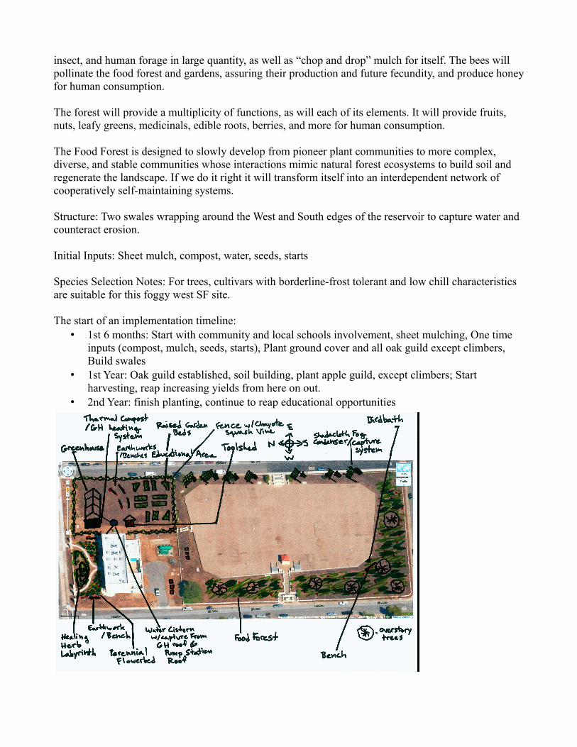
insect, and human forage in large quantity, as well as “chop and drop” mulch for itself. The bees will pollinate the food forest and gardens, assuring their production and future fecundity, and produce honey for human consumption.
The forest will provide a multiplicity of functions, as will each of its elements. It will provide fruits, nuts, leafy greens, medicinals, edible roots, berries, and more for human consumption.
The Food Forest is designed to slowly develop from pioneer plant communities to more complex, diverse, and stable communities whose interactions mimic natural forest ecosystems to build soil and regenerate the landscape. If we do it right it will transform itself into an interdependent network of cooperatively self-maintaining systems.
Structure: Two swales wrapping around the West and South edges of the reservoir to capture water and counteract erosion.
Initial Inputs: Sheet mulch, compost, water, seeds, starts
Species Selection Notes: For trees, cultivars with borderline-frost tolerant and low chill characteristics are suitable for this foggy west SF site.
The start of an implementation timeline:• 1st 6 months: Start with community and local schools involvement, sheet mulching, One time
inputs (compost, mulch, seeds, starts), Plant ground cover and all oak guild except climbers, Build swales
• 1st Year: Oak guild established, soil building, plant apple guild, except climbers; Start harvesting, reap increasing yields from here on out.
• 2nd Year: finish planting, continue to reap educational opportunities
Lake Merced TractBy: Lisa Barret
This report explains the context of the three PUC sites at Lake Merced – including both current land use and features and historical land use and features—analyzes the unique features of each site, and proposes ten permaculture design ideas to develop local components of a sustainable food system. The proposal also highlights relevant issues, such as the presence of pesticides, and addresses community concerns and groups that need to be part of any design considerations. Finally, the proposal presents a coherent long-term vision for use of the PUC sites that integrates elements of the ten individual design ideas. The integrated vision outlines how the three PUC sites can be designed to recover lost energy, cycle energy toward food production, grow food sustainably, and ensure that lake visitors, local residents, and area establishments directly benefit from both food production and food education at the three sites.
While many local conversations need to follow this proposal and precede design implementation, the potential to implement a sustainable program that aligns with the goals of Lake Merced advocates and supports the long-term health of lake ecosystems is both exciting and tangible.
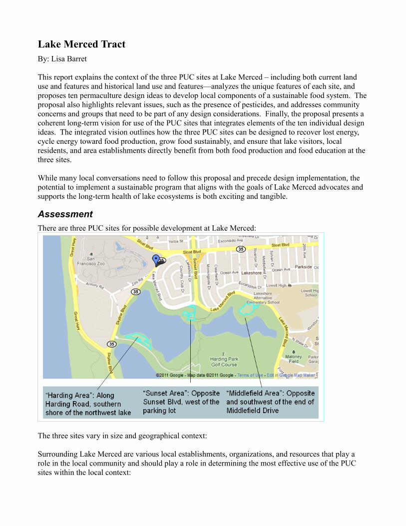
AssessmentThere are three PUC sites for possible development at Lake Merced:
The three sites vary in size and geographical context:
Surrounding Lake Merced are various local establishments, organizations, and resources that play a role in the local community and should play a role in determining the most effective use of the PUC sites within the local context:
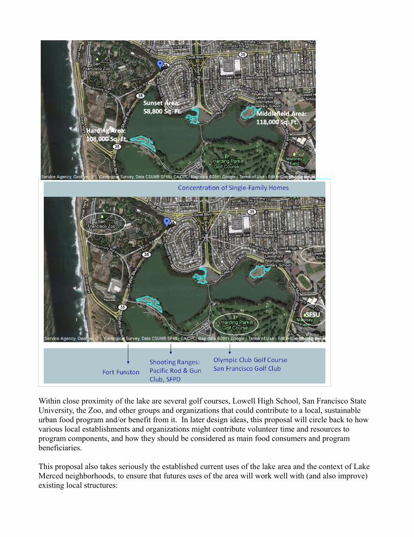
Within close proximity of the lake are several golf courses, Lowell High School, San Francisco State University, the Zoo, and other groups and organizations that could contribute to a local, sustainable urban food program and/or benefit from it. In later design ideas, this proposal will circle back to how various local establishments and organizations might contribute volunteer time and resources to program components, and how they should be considered as main food consumers and program beneficiaries.
This proposal also takes seriously the established current uses of the lake area and the context of Lake Merced neighborhoods, to ensure that futures uses of the area will work well with (and also improve) existing local structures:
Current uses and usage features: *• Biking/walking path around the lake– Thin but steady stream of walkers, runners, bikers, dog walkers– Walking paths give access to the lake and are used by walkers, student groups, and fishermen• Three Golf Courses• Several restaurants, including banquets, weddings, golf tournaments, and regular diners held at Harding Park
* Based on observations over two days, 7/2011
Current neighborhood: *• Mostly single family homes, denser on the north and west sides• Traffic on Skyline Blvd. on the west side of the lake is fast (45+ mph)– Almost no stop signs/intersections– Likely a high number of commuters– Relatively loud (both car and airplane noise)• Traffic on Lake Merced Blvd. on the east side is relatively slower (three5 mph)– More stops, traffic lights, residential off-shoot streets– Likely more residential traffic
* Based on observation over two days, 7/2011
An effective design will put local residents and lake users at its center, viewing them as the primary local consumers of, volunteers for, and contributors to the various program components. For example, residents may really appreciate a new local farmers’ market to buy good produce, but they may be more likely to go if it is in a highly visible location with easy access and attractive signage. Additionally, an effective design should complement current lake uses and goals to ensure community support and program success.
An effective permaculture design must also consider and work within the context of the area’s history, including changes to the lake area ecology and human impact over time, and Lake Merced has undergone significant changes in the past 200 years. In the late 1700s, the lake area was covered in sand dunes with minimal human usage, and the lake had an outlet to the sea. Today Lake Merced functions as a city park with many human uses and includes a range of micro-ecosystems around the lake that vary in soil quality, flora, and fauna. Today there are also numerous, well-established non-native species of plants and animals that co-exist with the remaining native species in and around the lake. The following is a brief history of Lake Merced and its uses.
Brief historical timeline:
• Before 1774:– Dune landscape and ecology– Lake had an outlet to the sea– Inhabited by Ohlone Indians who used the lake for fish• 1774 – 1868:
– Passed from the Spanish to the Mexicans, used for limited but increasing agriculture– Increased grazing led to decreased grasses, increased brush• 1868 – 1890– Sea outlet disappeared– Spring Valley Water Company purchased water rights and exercised near-monopoly on city water, holding the city hostage for drinking water and fire fighting needs– City of SF built Hetch-Hetchy to ensure stable water source• 1890-1950– Without a monopoly SVWC sold off land pieces, housing/development began to soar– Fort Funston was activated for military use in WWI and WWII• 1960 – present– Citizens established concern over water levels and loss of flora/natural habitat – PUC acquired water rights, charged with ensuring potable water supply and keeping water levels from dropping– Water levels and health of the fishery have fluctuated
Given both this historical context and the importance of contextualizing permaculture designs in local priorities, it is worth noting the priorities established by a 1998 report commissioned by the SFPUC for the purposes of establishing baseline information on the existing ecology of Lake Merced and setting goals for future management:
• The report stated that the number one priority of area management should be the use of Lake Merced as an emergency water source for San Francisco.
• The report also listed three goals for a suggested Natural Resources and Education Program:1. Enhance biodiversity.2. Minimize human impact.
3. Educate the public about natural resources and restoration.
These three priorities inform the design ideas outlined later in this proposal and the differentiated approach suggested for the three (very different) PUC areas.
Analysis of the Three Sites
The following analyses are based on site observations over two days in July 2011.
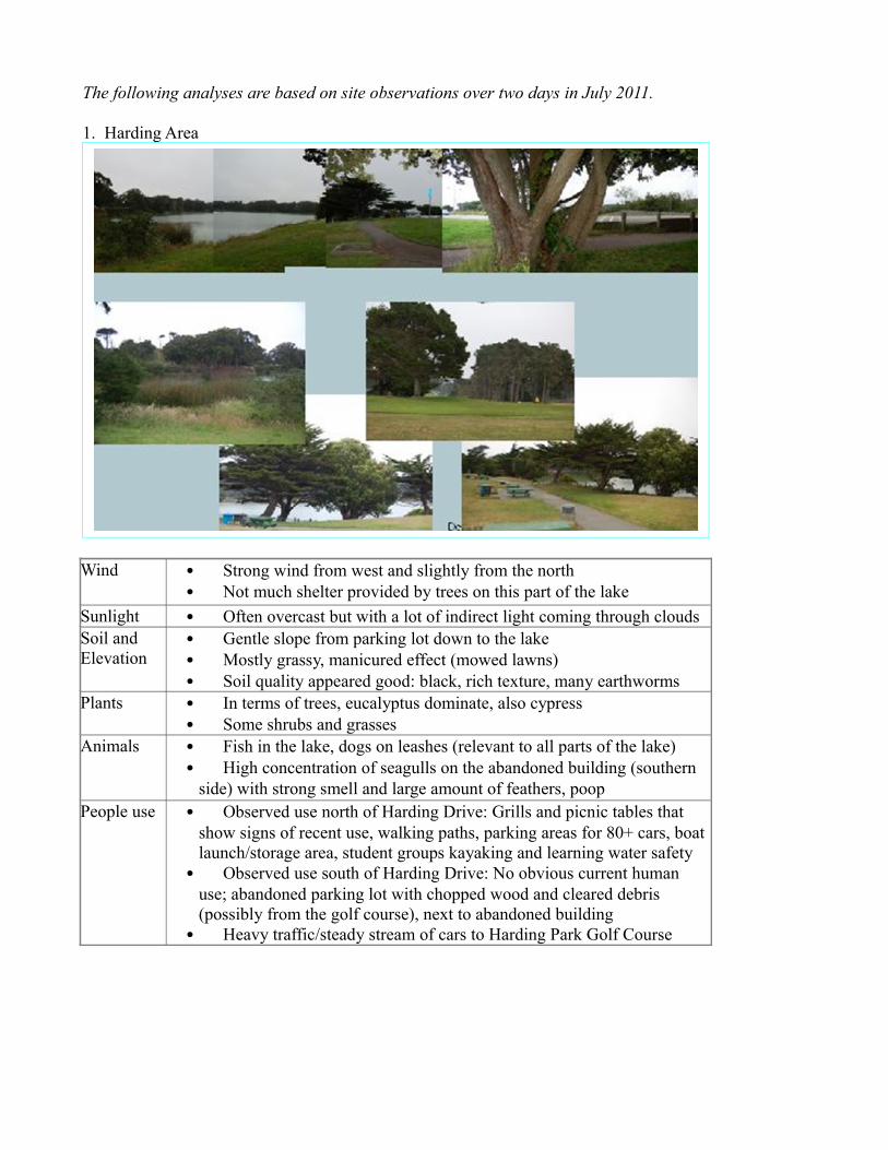
1. Harding Area
Wind • Strong wind from west and slightly from the north• Not much shelter provided by trees on this part of the lake
Sunlight • Often overcast but with a lot of indirect light coming through cloudsSoil and Elevation
• Gentle slope from parking lot down to the lake• Mostly grassy, manicured effect (mowed lawns)• Soil quality appeared good: black, rich texture, many earthworms
Plants • In terms of trees, eucalyptus dominate, also cypress• Some shrubs and grasses
Animals • Fish in the lake, dogs on leashes (relevant to all parts of the lake)• High concentration of seagulls on the abandoned building (southern
side) with strong smell and large amount of feathers, poopPeople use • Observed use north of Harding Drive: Grills and picnic tables that
show signs of recent use, walking paths, parking areas for 80+ cars, boat launch/storage area, student groups kayaking and learning water safety
• Observed use south of Harding Drive: No obvious current human use; abandoned parking lot with chopped wood and cleared debris (possibly from the golf course), next to abandoned building
• Heavy traffic/steady stream of cars to Harding Park Golf Course
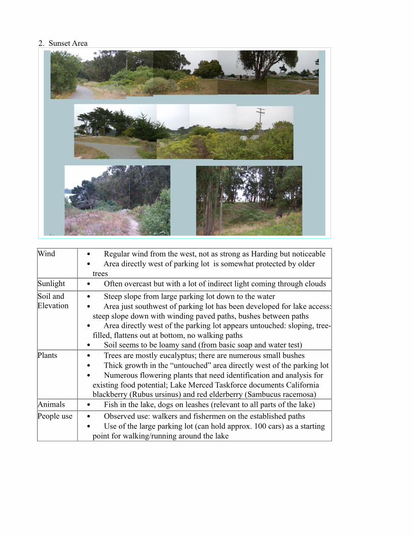
2. Sunset Area
Wind • Regular wind from the west, not as strong as Harding but noticeable• Area directly west of parking lot is somewhat protected by older
treesSunlight • Often overcast but with a lot of indirect light coming through cloudsSoil and Elevation
• Steep slope from large parking lot down to the water• Area just southwest of parking lot has been developed for lake access:
steep slope down with winding paved paths, bushes between paths• Area directly west of the parking lot appears untouched: sloping, tree-
filled, flattens out at bottom, no walking paths• Soil seems to be loamy sand (from basic soap and water test)
Plants • Trees are mostly eucalyptus; there are numerous small bushes• Thick growth in the “untouched” area directly west of the parking lot • Numerous flowering plants that need identification and analysis for
existing food potential; Lake Merced Taskforce documents California blackberry (Rubus ursinus) and red elderberry (Sambucus racemosa)
Animals • Fish in the lake, dogs on leashes (relevant to all parts of the lake)People use • Observed use: walkers and fishermen on the established paths
• Use of the large parking lot (can hold approx. 100 cars) as a starting point for walking/running around the lake
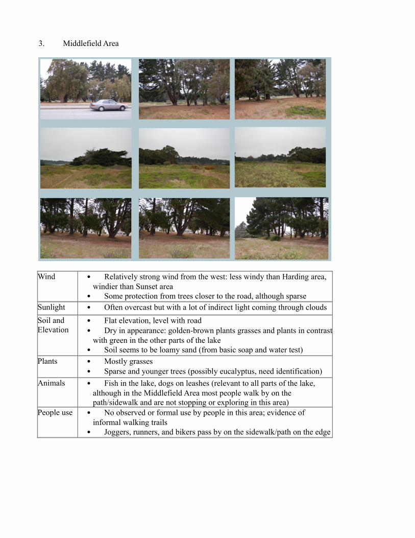
3. Middlefield Area
Wind • Relatively strong wind from the west: less windy than Harding area, windier than Sunset area
• Some protection from trees closer to the road, although sparseSunlight • Often overcast but with a lot of indirect light coming through cloudsSoil and Elevation
• Flat elevation, level with road• Dry in appearance: golden-brown plants grasses and plants in contrast
with green in the other parts of the lake• Soil seems to be loamy sand (from basic soap and water test)
Plants • Mostly grasses • Sparse and younger trees (possibly eucalyptus, need identification)
Animals • Fish in the lake, dogs on leashes (relevant to all parts of the lake, although in the Middlefield Area most people walk by on the path/sidewalk and are not stopping or exploring in this area)
People use • No observed or formal use by people in this area; evidence of informal walking trails
• Joggers, runners, and bikers pass by on the sidewalk/path on the edge
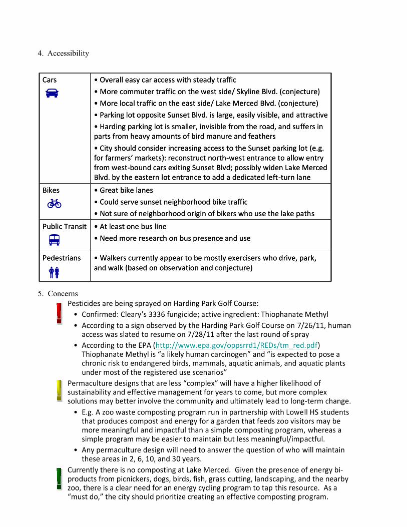
4. Accessibility
5. Concerns
• Great bike lanes• Could serve sunset neighborhood bike traffic• Not sure of neighborhood origin of bikers who use the lake paths
Bikes
• Walkers currently appear to be mostly exercisers who drive, park, and walk (based on observation and conjecture)
Pedestrians
• At least one bus line • Need more research on bus presence and use
Public Transit
• Overall easy car access with steady traffic• More commuter traffic on the west side/ Skyline Blvd. (conjecture)• More local traffic on the east side/ Lake Merced Blvd. (conjecture)• Parking lot opposite Sunset Blvd. is large, easily visible, and attractive• Harding parking lot is smaller, invisible from the road, and suffers in parts from heavy amounts of bird manure and feathers• City should consider increasing access to the Sunset parking lot (e.g. for farmers’ markets): reconstruct north-west entrance to allow entry from west-bound cars exiting Sunset Blvd; possibly widen Lake Merced Blvd. by the eastern lot entrance to add a dedicated left-turn lane
Cars
– Pesticides are being sprayed on Harding Park Golf Course: • Confirmed: Cleary’s 3336 fungicide; active ingredient: Thiophanate Methyl• According to a sign observed by the Harding Park Golf Course on 7/26/11, human
access was slated to resume on 7/28/11 after the last round of spray • According to the EPA (http://www.epa.gov/oppsrrd1/REDs/tm_red.pdf)
Thiophanate Methyl is “a likely human carcinogen” and “is expected to pose a chronic risk to endangered birds, mammals, aquatic animals, and aquatic plants under most of the registered use scenarios”
– Permaculture designs that are less “complex” will have a higher likelihood of sustainability and effective management for years to come, but more complex solutions may better involve the community and ultimately lead to long-term change.
• E.g. A zoo waste composting program run in partnership with Lowell HS students that produces compost and energy for a garden that feeds zoo visitors may be more meaningful and impactful than a simple composting program, whereas a simple program may be easier to maintain but less meaningful/impactful.
• Any permaculture design will need to answer the question of who will maintain these areas in 2, 6, 10, and 30 years.
– Currently there is no composting at Lake Merced. Given the presence of energy bi-products from picnickers, dogs, birds, fish, grass cutting, landscaping, and the nearby zoo, there is a clear need for an energy cycling program to tap this resource. As a “must do,” the city should prioritize creating an effective composting program.
Outstanding Questions
Many questions came up in researching design ideas to turn the PUC sites at Lake Merced into working parts of a sustainable urban food program. These questions should be fleshed out in the next phase of design and in ongoing discussions of appropriate, effective uses of these sites:
?? What pollutants are affecting the water quality of Lake Merced? What are possible permaculture solutions?
?? How can Harding Park Golf Course use non-chemical pesticides? How can the city enforce eco-friendly practices? Is there a local permaculture solution?
?? Does the zoo currently have an animal waste compost program? Does it compost/recycle all of its manure? How is energy regained from dead animals?
?? What existing relationships at Lowell High School and/or SFSU can facilitate management of urban food program structures at Lake Merced? Based on relationships to date, what is the assessment of effort it would require vs. impact it would have to leverage Lowell/SFSU to manage such structures?
?? What consumer markets can be tapped by food production at Lake Merced, e.g. Harding Park Golf Course (tournaments, dining, banquets, weddings, and normal users), SFSU community, shooting range visitors, local residents?
?? How sustainable is the fishery? Is it possible to run a sustainable fishing program in the lake, i.e. no restocking? Are there bi-products of the fishery that can be utilized for the energy cycle in an overall urban food program?
?? Is there a way to manage seagull manure to result in energy benefits and minimize annoyance (smell, appearance) for lake visitors?
?? What material are the clay pigeons used by the shooting ranges? Is there a good permaculture re-use for bi-products? Are there sustainable clay pigeon material options that can benefit an urban food program (a la rock dust)?
?? Should biogas also be explored as a possible use of zoo animal waste?
ScenariosThe following permaculture designs are potential ideas to maximize resources available at the Lake Merced sites, while considering the context of the Lake Merced ecology and local community resources.
Each design idea includes subjective “effort” and “impact” ratings of high, medium, or low, where “effort” means the amount of human time and resources required to start and maintain this design, and “impact” refers to how great of an impact this design can have on overall sustainable food production in SF.
These ideas are not mutually exclusive and ideally should be synthesized and integrated into an overall long-term vision. An integrated design proposal for the best use of the Lake Merced PUC sites follows the individual design ideas.
Design Scenario #1: Composting Program
Rationale: Compost recaptures energy and diverts materials that would otherwise end up in the waste stream. Good compost also means high food yield and has many potential uses.
Details:• Lowest level of effort: Create composting program in the Harding Area to capture energy from dog and picnickers’ compostable waste around the lake • Build enclosed compost bins that meet city regulations• Establish Lowell HS program to manage compost • Medium effort: Add on composting program to recover all grass and landscaping bi-products from Harding Park Golf Course• Enforce SF regulations for eco-friendly golf course management, potentially leveraging Friends of Lake Merced and Lake Merced Taskforce• Remove toxins through compost process• Medium effort: Add on composting component to recover lost energy from seagull guano and/or fish emulsion (high in N, P, K)• Create a fish-cleaning station to encourage fishermen to clean fish on-site and compost bi-products in special containers; manage emulsion process through designated, trained staff or volunteers• Collect seagull feathers and waste for compost, or design nesting areas that will concentrate waste for increased compost collection• Highest level of effort: Add on zoo bi-product composting program at the Middlefield site to recover massive amounts of available (unused) energy• Collect animal waste and dead animals• Compost through non-odorous processes (well-managed compost piles and black fly larvae programs)• Sell or offer top-quality soil for urban gardens, turning this area into a compost pick-up site• Could create green-collar jobs for SF residents
Design Scenario #2: Food Forest
Rationale: A food forest, once established, takes care of itself and complements lake goals to preserve natural species, beauty, and habitats.
Details:• Lowest level of effort: Preserving the current “wild” feel of the area directly west of the Sunset Blvd. parking lot, cultivate native food plants• Analyze existing plants for food potential• Create materials to teach what is available and how to cook with it, including posting signs to indicate what is ripe and not (and/or)• Teach local restaurants what is available and how to cook with it to reduce food miles for Lake Merced establishments• Low-medium effort: Cultivate additional fruits (e.g. berries) and vegetables that can grow in sandier soil
• Cultivate new food plants near existing walking paths, or construct limited additional walking paths from local, abundant materials• Bring in native food-producing plants that can also tackle erosion• Higher level of effort: • Cultivate native plants (more research needed) that can out-compete non-native plants (e.g. Eucalyptus); potentially sheet mulch specific areas• With invasive species under control, diversify with local plants in phase II
Design Scenario #3: Orchard
Rationale: The trees currently dominating the Harding and Middlefield Areas are invasive, non-native, and non-food producing. Orchards, once established, take little effort to maintain and bring joy to those who benefit.
Details:• Medium effort: Bring in appropriate local, fruiting frees to the Harding Area• Establish a wind break on the west side, near Skyline Blvd., which will cut noise and wind and allow for an orchard on the edge of the picnic area• Create a healthy guild with multiple nitrogen fixers, insectaries, etc. and with trees with varying harvesting seasons and that can prevent erosion• High effort: Create a fruit orchard in the Middlefield Area, which currently is largely unused and generally lacks native plant species• Designate an intensive composting and mulching area, leveraging available nutrient-rich sources (dog poop, zoo animal waste, picnickers)• After 1-2 years of intensive mulching, plants windbreaks, nitrogen fixers, appropriate keystones, climbers, insectaries, etc. in designated part• Manage harvesting with help from Lowell HS students or green collar city workers, posting signs to inform the community whether fruit is ripe/ready• Medium effort: Establish chicken flock at the base of the orchard, complemented by a black fly larvae compost program to feed them
Design Scenario #4: Small-scale food gardens
Rationale: Reduce food miles for local restaurants and consumers. Create a model that can be replicated in many local backyards.
Details:• Medium effort: Turn the unused south side of the Harding Area into garden plots with several potential uses:• Green collar city workers could receive training to manage the garden and sell or offer crops to local restaurants and residents• Local restaurants could lease space to grow food and reduce food miles• SFSU or Lowell HS students could lease or manage plots• Community members could lease or manage plots• Medium to high effort: Create a learning center in the Harding Area in the unused building or the newly developed food gardens
• Increase wind breaks to increase diversity of potential cultivars • Create a model garden with species and cultivar labels where city residents can come learn, pick a garden to replicate, and start a garden in their own backyards• Provide education about edible plants, mushrooms, nuts, etc.
Design Scenario #5: Farmers Market in Sunset Blvd. Parking Lot
Rationale: The closest farmers’ markets are currently at 8th & Irving and Stonestown. The Sunset Blvd. parking lot is large and highly visible to lake visitors and local traffic patterns.
Details:• High effort: Redesign parking lot entrances and traffic lanes and redraw parking spots to increase accessibility and maximize space• Add left turn lane and parking entrance for drivers exiting Sunset Blvd. and heading west on Lake Merced Blvd.• Add dedicated left turn lane into the parking lot for drivers heading north on Lake Merced Blvd. from the east side of the lake• Add additional pedestrian crosswalks in the vicinity• Add attractive, hand-painted signs on all approaching streets• Medium effort: Run monthly or weekly farmers’ markets (start slow to gauge interest) • Manage through green collar city workers, SFSU students, or residents, depending on their readiness and goals of the market• Low effort: Set up roadside stands for seasonally grown produce• Self-managed booths, requiring minimal city oversight
Design Scenario #6: Food distribution center
Rationale: Significant energy is currently spent on packaging and refrigerating perishable foods. The cool climate of the lake creates the conditions for a green storage and distribution facility with “natural air conditioning.”
Details:• High effort: Revamp the abandoned building in the Harding Area to create a storage and distribution facility• Use root cellars and manage natural air circulation to regulate conditions year-round• Store tubers, squash, melons, etc. which can be stored and sold over several weekends of Farmers’ Markets• Use re-usable packaging and crates (wooden, cardboard)• High effort: Install egg vending machines to reduce food miles and support local, decentralized food exchange; if successful, expand to other products• Use cool climate (not electricity) to regulate temperature• Depends on local egg production/farmers to put eggs in the machine• Best location is Sunset Blvd. parking lot for accessibility; aesthetic design would be key
• Numerous preconditions (health regulations, physical design) for success
Design Scenario #7: High-Water-Usage Crop Cultivation
Rationale: Use lake water irrigation to cultivate crops that require high amounts of water. Create a specialty for lake food production. Reduce water use in other parts of the city.
Details:• High effort: Design gardens in the Harding area for high-water-need crops• Use multi-layered worm/compost bins to filter lake water, digest possible toxins in the water, and cycle water into simple, sub-soil drip irrigation system• Plant melons, cucumbers, and/or other high-water-need plants• Adjust light and wind (reflective light, natural wind breaks, etc.)• Create guilds with plants that match possible toxins, i.e. analyze toxins in the soil and water and introduce appropriate plants that can absorb or break down toxins to keep them out of food production• High effort: Replace invasive eucalyptus trees, which use a ton of water• Designate pieces of the Harding area to remove eucalyptus, sheet mulch, “restart” the soil, and envision new guilds of food-producing trees• Include a significant number of trees to break wind• Determine which trees can thrive in a relatively harsh, cold climate• Consider phasing in high-water-need trees and plants in designated plots of the Middlefield area, with years of soil-enrichment work/mulching
Design Scenario #8: Consumer Focus
Rationale: Focusing on the perspective of existing users can produce a simple, streamlined design approach, with the goal of complementing existing practices with sustainable designs.
Details:• Cyclists: Create a water re-fill station for cyclists with treated lake-water• Design attractive educational boards to promote sustainable practices• Explore using a root system to filter water (similar to using watercress to filter fish waste out of water in closed-loop aquaponic systems)• Zoo visitors: Sell sustainably-grown food to the zoo café/restaurant• Capitalize on visitors’ inherent interest in nature and the environment• Use zoo waste to grow plants to feed zoo visitors; highlight this cycle to zoo restaurant visitors to increase consumer interest and spread good practices• Zoo animals: Raise plants at the lake to feed zoo animals, reduce food miles• Walkers: Create a seasonal juice stand using fruit/berries grown at the lake• Address the fact that beverage consumption practices are particularly wasteful (packaging waste, many food miles, refrigeration energy)• Fishermen: Create a designated baiting and fish-cleaning area• Develop a worm/grub harvest program using dedicated plots/bins• Post attractive educational materials with sustainable practices/ regulations
• Provide an area to clean fish on site and recover “waste” for energy cycling
Design Scenario #9: Packaging
Rationale: There is a huge need for sustainable food packaging made from local, abundant sources. Willows and other weaving plants can grow in the lake climate.
Details:• Low effort: Analyze existing lake-side plants for weaving potential (for packaging production), and increase the abundance of plants that can be used for weaving material• Integrate planting of new plants with lake beautification goals, which should include planting more trees to reduce wind, reduce sound, and absorb pollutants• Establish Lowell HS program to appropriately harvest plants for weaving• Sell or provide raw packaging materials to local individuals who can produce sustainable packaging• Medium effort: Explore low-city-investment options for packaging production, e.g. hire or appoint community members or SFSU art students to develop a weaving program• Medium-high effort: Establish formalized, commercial packaging program• Invest in branding• Invest in tools or machinery, as well as location
Design Sceanrio #10: Seagull Management
Rationale: Although seagull management alone is not necessary for urban food production, if integrated with sustainable agriculture practices at Lake Merced it will recover energy (scat) for nutrient cycling, improve the appeal of the lake to visitors and potential food buyers, and address possible disease transmission.
Details:• Low effort: Introduce closed compost, recycling, and garbage containers around the lake to remove unintended seagull food sources• Include effective educational signs on the importance of proper waste disposal and proper trash separation• As part of regular park clean-up activities, collect feathers and poop from Harding Area and deposit into the compost area on site• Medium effort: Design structures that will attract gulls to roost, in order to manage and concentrate the population and recover waste products/energy• On land: Add an aesthetically attractive and gull-friendly rooftop design to the abandoned building in the Harding Area; use materials that will catch feathers and are easy to clean• Over water: Design a floating island with a mesh bottom to attract seagulls to roost and return feathers and poop to the water for energy cycling• Explore introducing a managed food scrap program, to manage human desire to feed the birds, e.g. mechanism to deposit crumbs on the island
Possible Integrated Design Scenario
Context:
An effective overall design for the Lake Merced PUC sites, to support the larger city goals of designing and promoting sustainable urban food programs across San Francisco, needs to integrate the various design ideas above into a comprehensive long-term vision. Then in order for the vision to move forward, the process must involve local stakeholders and community groups for the purposes of incorporating local input, aligning goals, and determining community commitments. This plan cannot be successful without the support and commitment of local groups (see Next Steps).
As alluded to previously, the goals of many Lake Merced advocates include preserving natural habitats and native species in and around the lake. Effective permaculture designs also depend on replicating and developing healthy, balanced ecosystems. Therefore the integrated design proposed here differentiates its approach to each PUC area, to consider the unique natural features of each:• Harding: The Harding Area presents a manicured setting with a traditional park feel (grass, picnic tables, paths, parking, outdoor activities). Therefore proposed design features are “hands-on,” bringing in sustainable human activities such as gardening and composting to complement existing uses.• Sunset: The Sunset Area is composed of a well-accessed, highly-used and paved area of human activity right alongside a largely untouched tract of trees, shrubs, and other plants. To complement these features, the proposed design preserves human and natural boundaries.• Middlefield: The Middlefield Area is a more unused (by humans), dry, sandy area with numerous invasive species. The presence of invasive species and the changes to this area over time suggest that appropriate management should preserve some of the existing features but requires significant human intervention to address current imbalances in the micro- ecosystem. The proposed design features therefore strive to achieve a middle ground between preservation and re-envisioning of this area.
This proposal also makes assumptions about the human resources necessary to set up and then manage ongoing Lake Merced design components and includes some ideas for human resourcing in the text below in italics. The assumptions need to be scrutinized and refined before finalizing the program design. To manage all aspects of the proposed program, a paid site-manager position could be a full-time, city-funded, green-collar job that conceivably pays for itself or is subsidized through the successful sale of crops, food products, and high-quality soil from the program. However, to determine the most effective management and staffing structure, a detailed analysis will need to be undertaken to confirm true costs and projected profits/outcomes of the program, as well as available community resource to help sustain it.
Rationale:
The integrated design proposal naturally combines the individual design elements by weighing the benefits of any component or strategy against the effort it will take to implement that component, in order to ensure the overall plan is not only effective but efficient. The integrated design proposal also continues to focus on local context: how to ensure benefits to local users
and expand the impact into local establishments, backyards, and routines.
More specifically, the integrated design proposal stems directly from the larger permaculture goal to maximize use of the PUC sites to support sustainable food practices in San Francisco. Therefore, the integrated design proposal• Pulls out individual design ideas that are high impact, in order to maximize use of the available land (e.g. composting is a central feature, seagull management is not) and focuses on implementation of these ideas.• Selects lower-effort means of achieving high-impact results (e.g. creating a compost program in the Harding Area with existing lake waste products) to work most efficiently and also take advantage of “low-hanging fruit.”• Only selects higher-effort strategies with significant positive impacts (e.g. a zoo animal waste composting program is a big operation but benefits a significant numerous city residents in multiple ways, from increasing soil quality in the PUC sites to helping farmers throughout the city fertilize new gardens to reducing landfill quantities to increasing food production).• Includes a diverse range of program components in order to broaden the impact of this work by affecting multiple users (e.g. restaurants, fishermen, local households and shoppers, etc.).• Offers multiple entry points for long-term impact opportunities, including through educational materials and training sessions (e.g. food foraging can become a high-impact activity if sustainable practices are replicated by visitors in their own backyards or replace previously-practiced non-sustainable approaches).• Thinks both short- and long-term by• Ensuring that immediate, tangible results (“quick wins”) will build immediate community support (e.g. food production in gardens and food forest), and• Putting in place design components that will help local residents internalize and implement permaculture practices (e.g. through model gardens, food foraging, local egg production, etc.) for years to come.• Increases in complexity year over year to ensure incremental success (e.g. starts with gardens only in the Harding Area – the natural choice –but builds soil quality in the Middlefield Area to eventually implement a well-managed guild there, expands the Harding Area gardens to increase impact and scope, etc.).• Addresses issues that are obstacles to success (including the presence of toxins and harsh wind which will affect human use and enjoyment of the area no matter what, in addition to permaculture success).
Long-Term Vision:
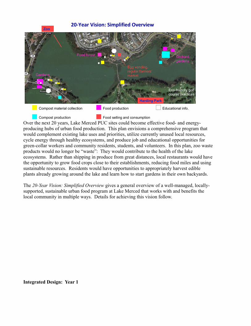
Over the next 20 years, Lake Merced PUC sites could become effective food- and energy-producing hubs of urban food production. This plan envisions a comprehensive program that would complement existing lake uses and priorities, utilize currently unused local resources, cycle energy through healthy ecosystems, and produce job and educational opportunities for green-collar workers and community residents, students, and volunteers. In this plan, zoo waste products would no longer be “waste”: They would contribute to the health of the lake ecosystems. Rather than shipping in produce from great distances, local restaurants would have the opportunity to grow food crops close to their establishments, reducing food miles and using sustainable resources. Residents would have opportunities to appropriately harvest edible plants already growing around the lake and learn how to start gardens in their own backyards.
The 20-Year Vision: Simplified Overview gives a general overview of a well-managed, locally-supported, sustainable urban food program at Lake Merced that works with and benefits the local community in multiple ways. Details for achieving this vision follow.
Integrated Design: Year 1
20-Year Vision: Simplified Overview
Compost material collection
Compost production
Eco-friendly golf course practices
Food forest
Food production
Food selling and consumption
Egg vending, regular farmers’market
Zoo
Harding Park
Gardens
Orchard, gardens
Educational info.
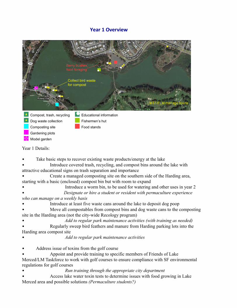
Year 1 Details:
• Take basic steps to recover existing waste products/energy at the lake• Introduce covered trash, recycling, and compost bins around the lake with attractive educational signs on trash separation and importance• Create a managed composting site on the southern side of the Harding area, starting with a basic (enclosed) compost bin but with room to expand• Introduce a worm bin, to be used for watering and other uses in year 2• Designate or hire a student or resident with permaculture experience who can manage on a weekly basis• Introduce at least five waste cans around the lake to deposit dog poop• Move all compostables from compost bins and dog waste cans to the composting site in the Harding area (not the city-wide Recology program)• Add to regular park maintenance activities (with training as needed)• Regularly sweep bird feathers and manure from Harding parking lots into the Harding area compost site • Add to regular park maintenance activities
• Address issue of toxins from the golf course• Appoint and provide training to specific members of Friends of Lake Merced/LM Taskforce to work with golf courses to ensure compliance with SF environmental regulations for golf courses• Run training through the appropriate city department• Access lake water toxin tests to determine issues with food growing in Lake Merced area and possible solutions (Permaculture students?)
Year 1 Overview
Compost, trash, recycling
Composting site
Dog waste collection
Collect bird waste for compost
LMTF/FLM manage toxins
Berry bushes, food foraging
Gardening plots
Fishermen’s hut
Food stands
Educational information
Model garden
• Recover all landscape bi-produces (tree branches, etc.) and grass clippings from golf courses to the new Harding Area composting site• Golf course employees, with training from park staff
• Lay the groundwork for foraging/a food forest approach in Sunset Blvd. Area• Catalogue existing edible cultivars around the Sunset Blvd. parking lot • Develop educational materials on culinary uses and preparation• Plant and cultivate additional berry bushes near existing walkways• Enlist permaculture-trained students, residents, and professionals to catalogue existing plants, create materials, and cultivate new plants
• Designate and begin to plant model gardens/guilds in the Harding Area• Work with the Lake Merced taskforce to establish and address known toxins• Mark off plots in the northwestern section of Harding where soil quality appears high and human usage is minimal• Plant appropriate fruiting trees• Design guilds with heavy windbreak and a number of nitrogen fixers, dynamic accumulators, pest suppressors, insectaries, etc.• Monitor soil quality and, as needed, add good mulch from the new managed compost bins in the Harding area• Plan with birds in mind: Consider plants that will attract birds and collect waste/fertilize the soil, and plants that will be eaten by local birds• Train green collar workers and Lowell HS volunteers to manage model gardens and mark plant species for community education
• Establish a simple fishermen’s hut by the lake, near Sunset Blvd. parking lot: wooden table with wooden roof covering, open air• Introduce a black fly larvae compost bin or emulsion program for fish guts• Larvae that are ready to hatch will travel up a tube and drop down into the lake to be eaten by fish• Explore a bin design solution to be able to also use fly larvae for bait• Introduce a worm bin for bait, building off of the Harding compost site• Establish fish-gutting and cleaning area and gut deposit• Establish well-posted rules for sustainable fishing and lake usage• Enlist permaculture-trained students, residents, and/or professionals to set up and manage this area• Train Lowell HS volunteers to assist with maintenance
• Establish several small food stands by the lake to act as simple, informal “pop-up” farmers’ markets for lake visitors (requiring no city management)
Integrated Design Proposal: Year 2
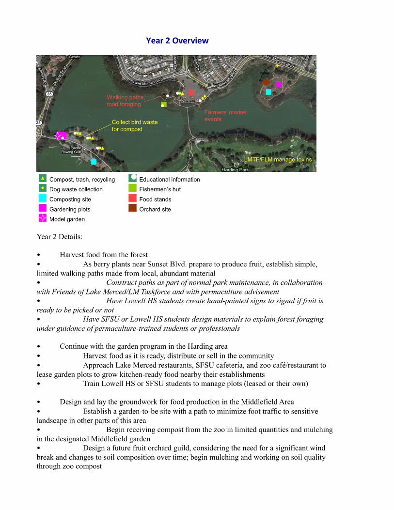
Year 2 Details:
• Harvest food from the forest• As berry plants near Sunset Blvd. prepare to produce fruit, establish simple, limited walking paths made from local, abundant material• Construct paths as part of normal park maintenance, in collaboration with Friends of Lake Merced/LM Taskforce and with permaculture advisement• Have Lowell HS students create hand-painted signs to signal if fruit is ready to be picked or not• Have SFSU or Lowell HS students design materials to explain forest foraging under guidance of permaculture-trained students or professionals
• Continue with the garden program in the Harding area• Harvest food as it is ready, distribute or sell in the community• Approach Lake Merced restaurants, SFSU cafeteria, and zoo café/restaurant to lease garden plots to grow kitchen-ready food nearby their establishments• Train Lowell HS or SFSU students to manage plots (leased or their own)
• Design and lay the groundwork for food production in the Middlefield Area• Establish a garden-to-be site with a path to minimize foot traffic to sensitive landscape in other parts of this area• Begin receiving compost from the zoo in limited quantities and mulching in the designated Middlefield garden • Design a future fruit orchard guild, considering the need for a significant wind break and changes to soil composition over time; begin mulching and working on soil quality through zoo compost
Year 2 Overview
Compost, trash, recycling
Composting site
Dog waste collection
Collect bird waste for compost
LMTF/FLM manage toxins
Walking paths, food foraging
Gardening plots
Fishermen’s hut
Food stands
Orchard site
Farmers’ market events
Educational information
Model garden
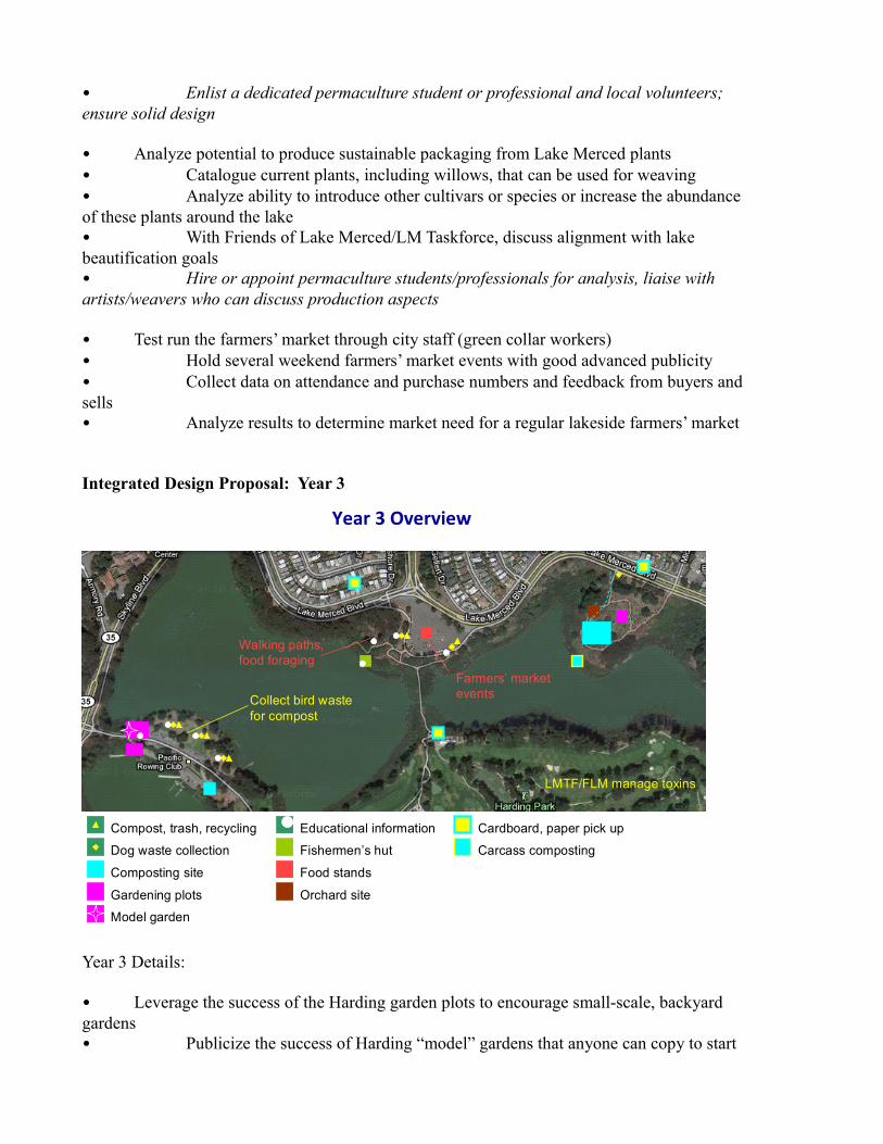
• Enlist a dedicated permaculture student or professional and local volunteers; ensure solid design
• Analyze potential to produce sustainable packaging from Lake Merced plants• Catalogue current plants, including willows, that can be used for weaving• Analyze ability to introduce other cultivars or species or increase the abundance of these plants around the lake• With Friends of Lake Merced/LM Taskforce, discuss alignment with lake beautification goals• Hire or appoint permaculture students/professionals for analysis, liaise with artists/weavers who can discuss production aspects
• Test run the farmers’ market through city staff (green collar workers)• Hold several weekend farmers’ market events with good advanced publicity• Collect data on attendance and purchase numbers and feedback from buyers and sells• Analyze results to determine market need for a regular lakeside farmers’ market
Integrated Design Proposal: Year 3
Year 3 Details:
• Leverage the success of the Harding garden plots to encourage small-scale, backyard gardens• Publicize the success of Harding “model” gardens that anyone can copy to start
Year 3 Overview
Compost, trash, recycling
Composting site
Dog waste collection
Collect bird waste for compost
LMTF/FLM manage toxins
Walking paths, food foraging
Gardening plots
Fishermen’s hut
Food stands
Orchard site
Farmers’ market events
Educational information Cardboard, paper pick up
Carcass composting
Model garden
their own guilds• Label every cultivar in the model gardens with attractive, informative labels• Leverage permaculture-trained students or professionals to hold regular, well-publicized weekend sessions to teach local residents in the community how to copy the model gardens in their backyards (where soil, sun, wind conditions are ostensibly the same)• Lease additional plots in the Harding area to local restaurants
• Build off of the limited compost program in year 2 to scale up the composting of zoo animal waste and establish a high-quality soil production program in compost bins in the back part of the Middlefield area (run by SF green-collar workers)• Compost as much zoo animal waste as possible while managing odors• Set up a paper, cardboard, and other carbon-collection program in the neighborhood for compost use, to balance the manure• Establish a minimal dirt drop off lane for zoo/compost access only• Maintain the existing tree cover by the road to minimize changes in appearance and manage neighborhood perceptions• Sell or distribute high-quality compost for other gardens• Begin energy cycling component to process animal carcasses (Middlefield)• Use black fly larvae process to break down carcasses and return energy to the lake via larvae dropping into the water and being eaten by fish• Train green collar city workers or zoo workers to manage
• Continue other programs already in place• Continue to manage local composting program, use compost soil for Harding and Middlefield gardens, oversee food production in the gardens, keep an eye on golf course practices, and cycle back golf course waste• Upkeep food forest and fishing hut programs and educational signs
Integrated Design: Year 4
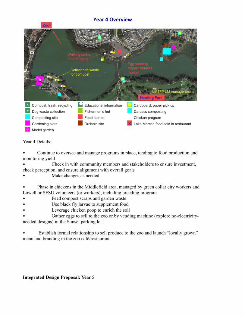
Year 4 Details:
• Continue to oversee and manage programs in place, tending to food production and monitoring yield• Check in with community members and stakeholders to ensure investment, check perception, and ensure alignment with overall goals• Make changes as needed
• Phase in chickens in the Middlefield area, managed by green collar city workers and Lowell or SFSU volunteers (or workers), including breeding program• Feed compost scraps and garden waste• Use black fly larvae to supplement food • Leverage chicken poop to enrich the soil• Gather eggs to sell to the zoo or by vending machine (explore no-electricity-needed designs) in the Sunset parking lot
• Establish formal relationship to sell produce to the zoo and launch “locally grown” menu and branding in the zoo café/restaurant
Integrated Design Proposal: Year 5
Year 4 Overview
Compost, trash, recycling
Composting site
Dog waste collection
Collect bird waste for compost
LMTF/FLM manage toxins
Walking paths, food foraging
Gardening plots
Fishermen’s hut
Food stands
Orchard site
Egg vending, regular farmers’market
Educational information Cardboard, paper pick up
Carcass composting
Chicken programx Lake Merced food sold in restaurant
Zoo
Harding Park
Model garden
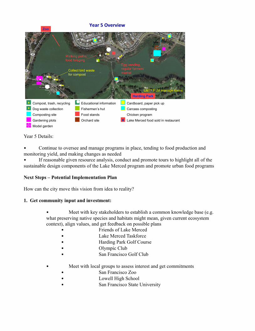
Year 5 Details:
• Continue to oversee and manage programs in place, tending to food production and monitoring yield, and making changes as needed• If reasonable given resource analysis, conduct and promote tours to highlight all of the sustainable design components of the Lake Merced program and promote urban food programs
Next Steps – Potential Implementation Plan
How can the city move this vision from idea to reality?
1. Get community input and investment:
• Meet with key stakeholders to establish a common knowledge base (e.g. what preserving native species and habitats might mean, given current ecosystem context), align values, and get feedback on possible plans
• Friends of Lake Merced• Lake Merced Taskforce• Harding Park Golf Course• Olympic Club• San Francisco Golf Club
• Meet with local groups to assess interest and get commitments• San Francisco Zoo• Lowell High School• San Francisco State University
Year 5 Overview
Compost, trash, recycling
Composting site
Dog waste collection
Collect bird waste for compost
LMTF/FLM manage toxins
Walking paths, food foraging
Gardening plots
Fishermen’s hut
Food stands
Orchard site
Egg vending, regular farmers’market
Educational information Cardboard, paper pick up
Carcass composting
Chicken programx Lake Merced food sold in restaurant
Zoo
Harding Park
Model garden
2. Establish goals:
• Contextualize Lake Merced goals within city and local food needs and goals
• Determine which groups should be primary beneficiaries of food production (e.g. should garden food be given away, or is it right to focus on getting restaurants to use local food to reduce their food miles?)
• Publicize goals to ensure shared understanding and accountability.
3. Revise and implement the plan.
San Francisco once again has the opportunity to be a national pace-setter. Across the country we have unsustainable, unhealthy food programs that we believe are efficient (because they are centralized) and effective (because we can eat whatever we want whenever we want it). But as more and more people are paying attention to the long-term consequences of industrial food production, now is the time to make change. A Lake Merced program can become one of many SF models of sustainable, healthy food practices in this city. And once residents see the many benefits of this work, they will get behind it.
Sources
“Conservation Projects Overview.” http://www.sfzoo.com/openrosters/ViewOrgPageLink.asp?LinkKey=14942&orgkey=1858. San Francisco Zoological Society, 2007. Web. 06 Aug. 2011.
http://www.harding-park.com/sites/courses/layout9.asp?id=1017&page=58531. TPC Harding Park, n.d. Web. 06 Aug. 2011.
“How do you Make Homemade Fish/Seaweed Emulsion?” Garden Web http://faq.gardenweb.com/faq/lists/organic/2002080041031662.html. iVillage Home and Garden Network, n.d. Web. 06 Aug. 2011.
“Lake Merced.” www.goldengateaudubon.org/conservation/make-the-city-safe-for-wildlife/lake-merced/. Golden Gate Audubon Society, 2009-2011. Web. 06 Aug. 2011.
“Lake Merced, San Francisco, California.” Yelp.com, n.d. Web. 30 Jul. 2011
“Lake Merced Watershed.” Guide to San Francisco Bay Area Creeks http://museumca.org/creeks/1700-RescMerced.html. Oakland Museum of California, n.d. Web. 06 Aug. 2011.
“Large Quantities of Guano.” Garden Web http://forums2.gardenweb.com/forums/load/organic/msg0215584615429.html. iVillage Home and Garden Network, 3 Feb. 2006. Web. 06 Aug. 2011.
www.lmtf.org. Lake Merced Task Force: An Organization of Lake Stewards and Advoocates, n.d. Web. 30 Jul. 2011.
“Reregistration Eligibility Decision: Thiophanate-Methyl.” Prevention, Pesticides and Toxic Substances http://www.epa.gov/oppsrrd1/REDs/tm_red.pdf. United States Environmental Protection Agency, Oct. 2005. Web. 06 Aug. 2011.
“Seagull Population Management.” http://www.fbiltd.co.uk/seagulls.htm Web. 05 Aug 2011. Flybird Installations Ltd., 2008. Web. 05 Aug. 2011.
SFSU Master Plan. http://www.sfsumasterplan.org/analysis_08.html. San Francisco State University, n.d. Web. 30 Jul. 2011.
Turner, Grahame. “The Best Practice Guide to Urban Bird Management.” Network Bird www.networkbird.net/pdf/think-bird-guide.pdf. P + L Systems, n.d. Web. 3 Aug. 2011.
Van Houton, Tom. “A short history of Lake Merced.” www.outsidelands.org. Western Neighborhoods Project, 6 Oct. 2004. Web. 30 Jul. 2011.
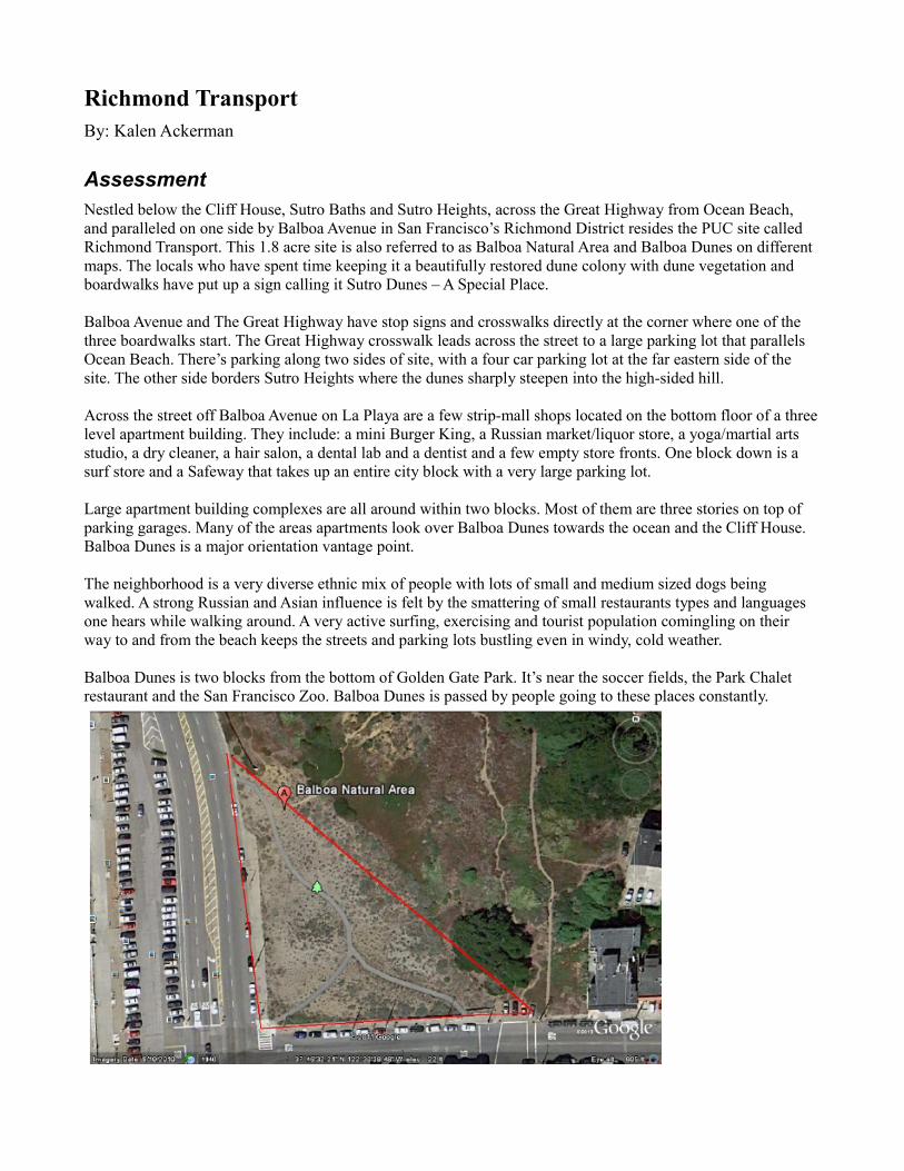
Richmond TransportBy: Kalen Ackerman
Assessment Nestled below the Cliff House, Sutro Baths and Sutro Heights, across the Great Highway from Ocean Beach, and paralleled on one side by Balboa Avenue in San Francisco’s Richmond District resides the PUC site called Richmond Transport. This 1.8 acre site is also referred to as Balboa Natural Area and Balboa Dunes on different maps. The locals who have spent time keeping it a beautifully restored dune colony with dune vegetation and boardwalks have put up a sign calling it Sutro Dunes – A Special Place.
Balboa Avenue and The Great Highway have stop signs and crosswalks directly at the corner where one of the three boardwalks start. The Great Highway crosswalk leads across the street to a large parking lot that parallels Ocean Beach. There’s parking along two sides of site, with a four car parking lot at the far eastern side of the site. The other side borders Sutro Heights where the dunes sharply steepen into the high-sided hill.
Across the street off Balboa Avenue on La Playa are a few strip-mall shops located on the bottom floor of a three level apartment building. They include: a mini Burger King, a Russian market/liquor store, a yoga/martial arts studio, a dry cleaner, a hair salon, a dental lab and a dentist and a few empty store fronts. One block down is a surf store and a Safeway that takes up an entire city block with a very large parking lot.
Large apartment building complexes are all around within two blocks. Most of them are three stories on top of parking garages. Many of the areas apartments look over Balboa Dunes towards the ocean and the Cliff House. Balboa Dunes is a major orientation vantage point.
The neighborhood is a very diverse ethnic mix of people with lots of small and medium sized dogs being walked. A strong Russian and Asian influence is felt by the smattering of small restaurants types and languages one hears while walking around. A very active surfing, exercising and tourist population comingling on their way to and from the beach keeps the streets and parking lots bustling even in windy, cold weather.
Balboa Dunes is two blocks from the bottom of Golden Gate Park. It’s near the soccer fields, the Park Chalet restaurant and the San Francisco Zoo. Balboa Dunes is passed by people going to these places constantly.
*Detailed maps are available in the Ocean Beach Master Plan
Dimensions: The space is 1.8 acres. Shaped like a wedge the perimeters are approximately 462ft (hillside) X 311ft (along Balboa) X 323ft (along the Great Highway).
Elevation Characteristics: Mostly level, but rolling-dune topography getting higher towards the back as it rises up to meet Sutro Dunes. The lot is wedge/triangle shaped and approximately 25ft above sea level depending on the tides. As the ocean is directly across the street the tide is important and the site will be greatly affected by rising sea levels due to climate change.
Sector Analysis (Wind, Sun, People, animals): Animals: Pelicans, gulls, plovers, dogs, seals, shorebirds . . . Weather: Windy, damp, cool, fog. Temperatures range between 36 to 75, on average, with some higher temps in the summer and early fall. People: Surfers, tourists, dog walkers, people riding bikes on the bike path, cars and buses
Accessibility (vehicular and personal): Major Muni hub one block away, bicycle paths, parking everywhere
Nearby neighborhood groups and organizations related to food system: Integral to helping with any project in the area would be PAR - Planning Association of the Richmond - http://www.sfpar.org/site/about-par.html - PAR is San Francisco's largest membership-based neighborhood organization. Established in 1970, PAR has a dues-paying membership of about 1,400 Richmond District households and businesses. ii
PAR’s mission includes: To develop and implement policies and recommendations for that maintain and enhance the physical and social dimensions of life in the Richmond District. To stimulate formation of neighborhood organizations in the areas of the Richmond District currently unserved. To support individual associations in pursuing issues relating to planning and the physical and social environment.iii
Other organizations: Local Harvest: http://www.localharvest.org/ SF Planning & Urban Research: http://www.spur.org/ San Francisco Recreation and Park Department: http://sfrecpark.org/Rec-CommunityServices.aspx San Francisco Unified School District: http://www.sfusd.edu/ San Francisco Urban Agriculture Food Alliance: http://www.sfuaa.org/ Urban Permaculture Institute: http://www.upisf.com/ 3
Site history/ current/ past uses: Balboa Natural Area/Balboa Dunes/Balboaiv Location: Balboa Street & The Great Highway Established: 2002 Size: 1.8 acres Park Type: Dune History Playland at the Beach occupied this site from the 1920s until 1972. Before the site was restored back to dunes in 2002 it was used for construction staging for the Richmond Transport Project two blocks away. Sand from the construction site of the new de Young Museum was used to create dune mounds. Foredune vegetation was planted by Golden Gate National Recreation Area/Natural Areas Program staff and volunteers in 2003, 2004 and 2005.v
Natural History Until recently, most of western San Francisco was covered by a patchwork of wind-blown sand dunes, patches of flowering shrubs, and occasional oases of ponds edged by willow, wax myrtle and oak.vi
Natural to the The Balboa Dunes would be sand verbena, silver beach bur and coast strawberry.vii
Risks/Unknowns that are relevant (historical use, toxicity concerns, etc.): How much water could be created by fog catchment alone? How will rising sea levels and increasingly severe and frequent storms affect the dunes and the site due to its proximity to the ocean? How toxic is the soil? Will a glass greenhouse be strong enough to withstand the salt air and the strong winds? Will there be people who want to bring these ideas to fruition and will there be enough interest to keep the ideas going? Shared risk of CSAs – will the clients get frustrated if they don’t get the goods they think they should be getting?
ScenariosWhen choosing strategies for the PUC Richmond Transport site I wanted to do accomplish two goals. I wanted to bring in elements that brought the community together in a nice gathering space and I wanted to bring fresh foods and food education to the neighborhood. To do this I chose to incorporate a Greenhouse for plant propagation and plant education, a mobile Farmstand for a CSA drop-off point and food education, fog catchment screens for water collection and Belgian/espalier fencing to surround the site and make it more secure while adding a small amount of food.
Green house/farm stand: The introduction of a greenhouse and a farm stand will be used for Belgian fence tending, propagating of dune plants and Belgian fence plants, dispersal of foods, education/classes/workshops and community gathering. Dune vegetation will be important as storms get more severe and sea levels rise. Propagation of dune vegetation will make sure that threatened species will have back-up if they need to be replanted. The farm stand and greenhouse may even inspire the neighbors to create their own kitchen gardens. 4
CSA drop-off : Drop-off point for CSA boxes, clients can collect boxes and chat with farmers. Community Supported Agriculture (CSA) are a way for the consumer to buy local, seasonal food directly from a farmer. Here are the basics: a farmer offers a certain number of "shares" to the public. Typically the share consists of a box of vegetables, but other farm products may be included. Interested consumers purchase a share (aka a "membership" or a "subscription") and in return receive a box (bag, basket) of seasonal produce each week throughout the farming season. viii
CSA locations gathered from OM Organics website as of 8.20.11 that deliver to SF: http://www.omorganics.org/page.php?pageid=107&contentid=90 Covelo Organic - Farm: Fruit, mixed vegetables Farm Fresh to You - Most from Capay Farm: Fruit, mixed vegetables, nuts Full Belly Farm - Farm: Fruit, mixed vegetables, nuts Good Humus - Farm: Fruit, mixed vegetables, flowers, herbs Green Hearts Family Farm - Farm: Fruit, mixed vegetables; pastured eggs and chickens and grass fed beef and pork Happy Child CSA (Frog Hollow Farm) - Farm: Fruit Herbert Family Organic Farm - Eating With the Seasons - Farm: Fruit, mixed vegetables High Ground Organics (along with Mariquita Farm) - 2 small farms: Fruit, mixed vegetables, flowers (if requested) Marin Sun Farms - Meat - Farm: Steaks, roasts, ground beef, lamb, goat, pork, veal, poultry Mariquita Farm (along with High Ground Organics)- 2 small farms: Fruit, mixed vegetables, flowers (if requested) Shooting Star CSA - Farm: Mixed vegetables, melons Soul Food Farm - Meat Terra Firma Farm Farm: Fruits, mixed vegetables, nuts Winter Creek Gardens Farm: Fruit, mixed vegetables
Belgian Fence : Create a beautiful, edible barrier between the heavily populated roads and the site. Protect kids, dogs and creates a place to gather. A Belgian fence is a type of espalier, composed of living tree, which is both attractive and useful. Using fruit trees for a Belgian fence provides a harvest as well as a barrier. Creating a Belgian fence is a long process, starting with young saplings called whips that are trained in a criss-cross lattice pattern.x
Plant selection: For the Belgian fence I chose plants that did well in zone 17 (mild, wet, frostless winters and cool summers with frequent fog or wind). For the base tree I chose the Brush Cherry and to intertwine between the branches I chose Marionberry and Blueberry. For the understory I chose cabbage, artichoke and cauliflower. Brush Cherry (Syzvgium panicultum) – Can be sheared into formal shapes and hedges, making a common background or screen plant. Oblong, 1/2 –3-in.-long leaves come in rich glossy green, often tinged with bronze; new growth is reddish bronze. Small, creamy white summer flowers have conspicuous tufts of stamens that look like little brushes. Blossoms are followed by showy, edible, 3/4-in., rosy purple fruit that is … good in jellies. xi
Marionberry : Cross of Chehalem x Olallie berries, this is a trailing, midseason berry whose rich, flavorful fruit sets the standard. Thorny canes can grow 10 ft. in a season, but are commonly controlled by pruning and trellising. Roots are perennial, but canes are biennial: they grow to full length the first season. The second season they bear clusters of white flowers followed by fruit.xii
Blueberry (rabbiteye): Handsome shrubs suitable for hedges or shrub borders. Leaves, to 3 in. long, are bronze when new, maturing to dark green, turning scarlet or yellow in fall. Tiny, urn-shaped spring flowers are white or pinkish.xiii
Understory/vegetables: Cabbage, cauliflower, artichoke:
Fog water catchment: use runoff for greenhouse and to water Belgian fence and understory plants The fog water catchment concept would be placed towards the back of the site as the site gets steep and human access is limited. This design is being used with ever increasing success in many parts of the world.
Here’s how they worked it out in Peru: Fog collection works not by condensation, which is what happens when water vapor hits a cold surface and transforms into a liquid. In fact, the water in fog is already in liquid form—it's just in very, very small drops.xiv
The collectors . . . started with what look like giant volleyball nets, 13 feet (4 meters) tall and 26 feet (8 meters) wide. The nets, perpendicular to the prevailing wind, stretch between pairs of wooden poles. The top of each net is 18 feet (5.5 meters) above the ground. As wind blows the heavy fog through, tiny droplets stick to the coarse woven mesh, made of a kind of plastic netting that is designed to shade young fruit trees. As more and more tiny droplets stick to the net, they clump together and form drops, and eventually gravity pulls the drops down into a gutter. From there, the water flows through tubes into two brick tanks and a pool . . . on a good day, a single net in Bellavista can collect an impressive amount of water—more than 150 gallons (568 liters).xv
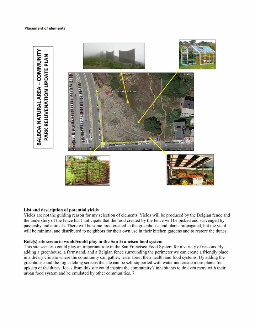
List and description of potential yields Yields are not the guiding reason for my selection of elements. Yields will be produced by the Belgian fence and the understory of the fence but I anticipate that the food created by the fence will be picked and scavenged by passersby and animals. There will be some food created in the greenhouse and plants propagated, but the yield will be minimal and distributed to neighbors for their own use in their kitchen gardens and to restore the dunes.
Role(s) site scenario would/could play in the San Francisco food system This site scenario could play an important role in the San Francisco Food System for a variety of reasons. By adding a greenhouse, a farmstand, and a Belgian fence surrounding the perimeter we can create a friendly place in a dreary climate where the community can gather, learn about their health and food systems. By adding the greenhouse and the fog catching screens the site can be self-supported with water and create more plants for upkeep of the dunes. Ideas from this site could inspire the community’s inhabitants to do even more with their urban food system and be emulated by other communities. 7
Possible Integrated Design Vision:The highest use for the site is the addition of a greenhouse and mobile farmstand with a CSA drop-off site.
Elements Greenhouse: Plant propagation – dune plants and Belgian fence plants Attractive design adds an element of beauty to a sparse landscape A place for people to gather and learn. A place for city dwellers to get in touch with nature and how the food system works. A point of pride for the neighborhood.
Farmstand: CSA drop-off point Education for kitchen gardens Foods procured at the farmstand can be eaten and composted in kitchen gardens Community gathering place, sharing common goals and meeting your neighbors Mobile so it can be moved and adapted as needs of community change Quirky design will attract interest and a give a splash of country charm to the city
CSA drop-off point: Organic, healthy foods for city dwellers Seasonal eating Bringing the foods closer to the consumer, taking the need to buy foods from neighboring Safeway that are not sustainable Connection to the land and farmers Place to talk to the farmer’s and learn Inspiration for community to get more involved – community gardens, farmer’s markets . . . A place for neighbor’s to meet each other and share experiences
Goals To create a beautiful and inspiring place out of a wedge of sand To bring healthy foods and the country to the city To bring people together and create a community To educate and excite people so they want to be more involved in their city and its food system To create alliances of people who want to take their community to the next level. For instance, create community gardens in their apartment complexes, in their medians, on their roofs. Diverse ethnic populations will want a diverse product assortment and introduce new foods to the community Freshen-up, brighten-up, liven-up, community action-up the Richmond District.
Justification/summary: My justification for the greenhouse, farmstand and CSA drop-off is two-fold – community and healthy food. The Richmond District is a bustling community but disjointed. Tight, insular ethnic communities, egocentric surfers and tourists create the bustle, but they don’t create a sense of community. The area is very cool, windy, damp and dreary. By adding a beautiful focal point (greenhouse) and an interesting and attention grabbing farmstand and stocking it with delicious foods (CSA) I believe the people will gather and come together. Neighbors meeting neighbors. Neighbors inspiring neighbors. 8
i http://www.goldengateparkpreservation.org
ii http://www.sfpar.org/site/about-par.html iii http://www.sfpar.org/site/about-par.html iv http://sfnap.org/n_area/parks/na_bal.html v http://sfnap.org/n_area/parks/na_bal.html vi http://sfnap.org/n_area/parks/na_bal.html vii http://sfnap.org/n_area/parks/na_bal.html viii http://www.localharvest.org/csa/ ix http://www.localharvest.org/csa/
x http://www.sas.upenn.edu/~dailey/pixs/espalier/espaliers.jpeg xi http://plantfinder.sunset.com/sunset/plant-home.jsp
xii http://plantfinder.sunset.com/sunset/plant-home.jsp xiii http://plantfinder.sunset.com/sunset/plant-home.jsp
xiv http://news.nationalgeographic.com/news/2009/07/090709-fog-catchers-peru-water-missions/ xv http://news.nationalgeographic.com/news/2009/07/090709-fog-catchers-peru-water-missions/
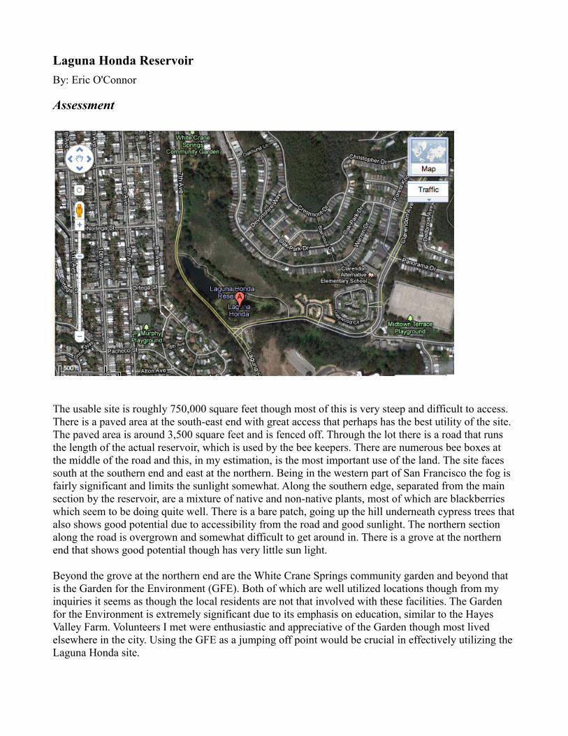
Laguna Honda ReservoirBy: Eric O'Connor
Assessment
The usable site is roughly 750,000 square feet though most of this is very steep and difficult to access. There is a paved area at the south-east end with great access that perhaps has the best utility of the site. The paved area is around 3,500 square feet and is fenced off. Through the lot there is a road that runs the length of the actual reservoir, which is used by the bee keepers. There are numerous bee boxes at the middle of the road and this, in my estimation, is the most important use of the land. The site faces south at the southern end and east at the northern. Being in the western part of San Francisco the fog is fairly significant and limits the sunlight somewhat. Along the southern edge, separated from the main section by the reservoir, are a mixture of native and non-native plants, most of which are blackberries which seem to be doing quite well. There is a bare patch, going up the hill underneath cypress trees that also shows good potential due to accessibility from the road and good sunlight. The northern section along the road is overgrown and somewhat difficult to get around in. There is a grove at the northern end that shows good potential though has very little sun light.
Beyond the grove at the northern end are the White Crane Springs community garden and beyond that is the Garden for the Environment (GFE). Both of which are well utilized locations though from my inquiries it seems as though the local residents are not that involved with these facilities. The Garden for the Environment is extremely significant due to its emphasis on education, similar to the Hayes Valley Farm. Volunteers I met were enthusiastic and appreciative of the Garden though most lived elsewhere in the city. Using the GFE as a jumping off point would be crucial in effectively utilizing the Laguna Honda site.
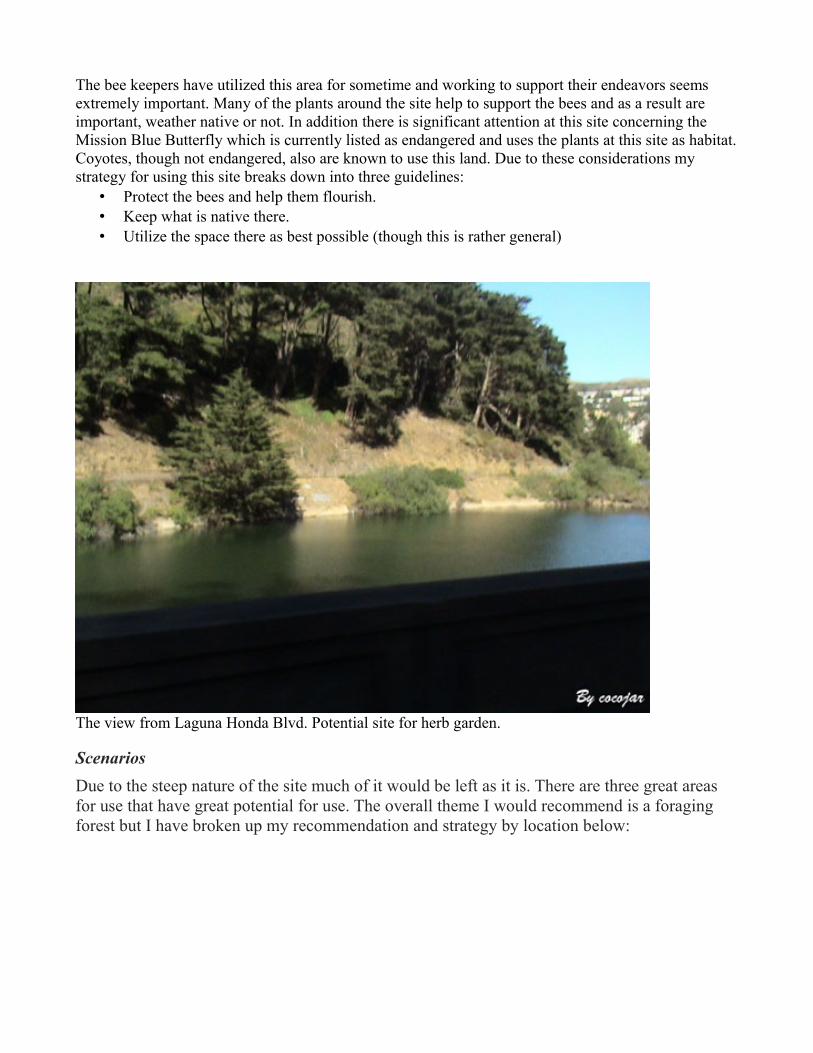
The bee keepers have utilized this area for sometime and working to support their endeavors seems extremely important. Many of the plants around the site help to support the bees and as a result are important, weather native or not. In addition there is significant attention at this site concerning the Mission Blue Butterfly which is currently listed as endangered and uses the plants at this site as habitat. Coyotes, though not endangered, also are known to use this land. Due to these considerations my strategy for using this site breaks down into three guidelines:
• Protect the bees and help them flourish.• Keep what is native there.• Utilize the space there as best possible (though this is rather general)
The view from Laguna Honda Blvd. Potential site for herb garden.
ScenariosDue to the steep nature of the site much of it would be left as it is. There are three great areas for use that have great potential for use. The overall theme I would recommend is a foraging forest but I have broken up my recommendation and strategy by location below:
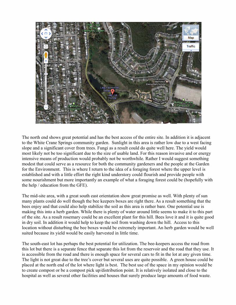
The north end shows great potential and has the best access of the entire site. In addition it is adjacent to the White Crane Springs community garden. Sunlight in this area is rather low due to a west facing slope and a significant cover from trees. Fungi as a result could do quite well here. The yield would most likely not be too significant due to the size of usable land. For this reason invasive and or energy intensive means of production would probably not be worthwhile. Rather I would suggest something modest that could serve as a resource for both the community gardeners and the people at the Garden for the Environment. This is where I return to the idea of a foraging forest where the upper level is established and with a little effort the right kind understory could flourish and provide people with some nourishment but more importantly an example of what a foraging forest could be (hopefully with the help / education from the GFE).
The mid-site area, with a great south east orientation show great promise as well. With plenty of sun many plants could do well though the bee keepers boxes are right there. As a result something that the bees enjoy and that could also help stabilize the soil as this area is rather bare. One potential use is making this into a herb garden. While there is plenty of water around little seems to make it to this part of the site. As a result rosemary could be an excellent plant for this hill. Bees love it and it is quite good in dry soil. In addition it would help to keep the soil from washing down the hill. Access to this location without disturbing the bee boxes would be extremely important. An herb garden would be well suited because its yield would be easily harvested in little time.
The south-east lot has perhaps the best potential for utilization. The bee-keepers access the road from this lot but there is a separate fence that separate this lot from the reservoir and the road that they use. It is accessible from the road and there is enough space for several cars to fit in the lot at any given time. The light is not great due to the tree’s cover but several uses are quite possible. A green house could be placed at the north end of the lot where light is best. The best use of the space in my opinion would be to create compost or be a compost pick up/distribution point. It is relatively isolated and close to the hospital as well as several other facilities and houses that surely produce large amounts of food waste.
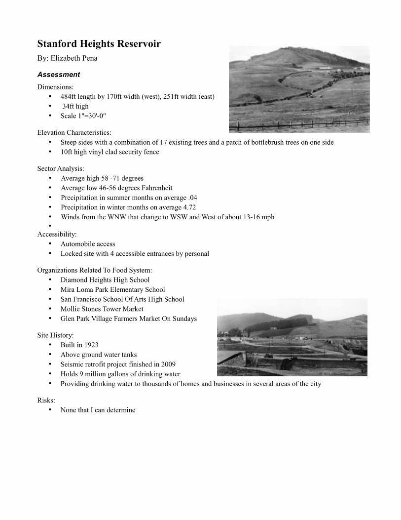
Stanford Heights ReservoirBy: Elizabeth Pena
Assessment Dimensions:
• 484ft length by 170ft width (west), 251ft width (east) • 34ft high• Scale 1"=30'-0"
Elevation Characteristics:• Steep sides with a combination of 17 existing trees and a patch of bottlebrush trees on one side• 10ft high vinyl clad security fence
Sector Analysis:• Average high 58 -71 degrees• Average low 46-56 degrees Fahrenheit • Precipitation in summer months on average .04• Precipitation in winter months on average 4.72 • Winds from the WNW that change to WSW and West of about 13-16 mph•
Accessibility:• Automobile access• Locked site with 4 accessible entrances by personal
Organizations Related To Food System:• Diamond Heights High School• Mira Loma Park Elementary School• San Francisco School Of Arts High School• Mollie Stones Tower Market• Glen Park Village Farmers Market On Sundays
Site History:• Built in 1923• Above ground water tanks• Seismic retrofit project finished in 2009• Holds 9 million gallons of drinking water• Providing drinking water to thousands of homes and businesses in several areas of the city
Risks:• None that I can determine
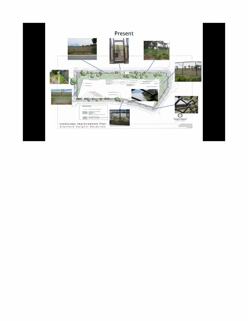
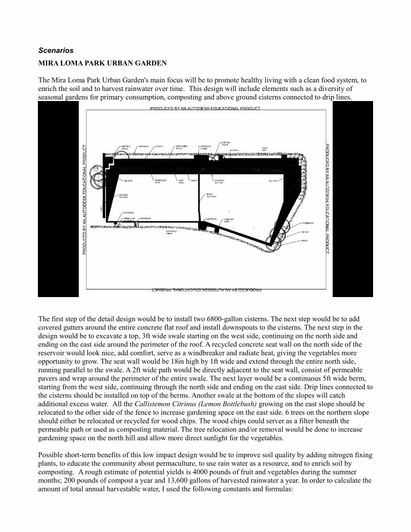
ScenariosMIRA LOMA PARK URBAN GARDEN
The Mira Loma Park Urban Garden's main focus will be to promote healthy living with a clean food system, to enrich the soil and to harvest rainwater over time. This design will include elements such as a diversity of seasonal gardens for primary consumption, composting and above ground cisterns connected to drip lines.
The first step of the detail design would be to install two 6800-gallon cisterns. The next step would be to add covered gutters around the entire concrete flat roof and install downspouts to the cisterns. The next step in the design would be to excavate a top, 3ft wide swale starting on the west side, continuing on the north side and ending on the east side around the perimeter of the roof. A recycled concrete seat wall on the north side of the reservoir would look nice, add comfort, serve as a windbreaker and radiate heat, giving the vegetables more opportunity to grow. The seat wall would be 18in high by 1ft wide and extend through the entire north side, running parallel to the swale. A 2ft wide path would be directly adjacent to the seat wall, consist of permeable pavers and wrap around the perimeter of the entire swale. The next layer would be a continuous 5ft wide berm, starting from the west side, continuing through the north side and ending on the east side. Drip lines connected to the cisterns should be installed on top of the berms. Another swale at the bottom of the slopes will catch additional excess water. All the Callistemon Citrinus (Lemon Bottlebush) growing on the east slope should be relocated to the other side of the fence to increase gardening space on the east side. 6 trees on the northern slope should either be relocated or recycled for wood chips. The wood chips could server as a filter beneath the permeable path or used as composting material. The tree relocation and/or removal would be done to increase gardening space on the north hill and allow more direct sunlight for the vegetables.
Possible short-term benefits of this low impact design would be to improve soil quality by adding nitrogen fixing plants, to educate the community about permaculture, to use rain water as a resource, and to enrich soil by composting. A rough estimate of potential yields is 4000 pounds of fruit and vegetables during the summer months; 200 pounds of compost a year and 13,600 gallons of harvested rainwater a year. In order to calculate the amount of total annual harvestable water, I used the following constants and formulas:
Constants:
• 0.62 gallons of rainwater falls on 1 square foot on land when 1 inch of rain is measured3
• 19.70 inches of normal annual rain1
• % Runoff Efficiency + 95% for concrete, flat roof2
• Design calls for the use of two 6800 gallon cisterns
Formulas (sample calculation):
Total gallons of rainfall received annually by 1 square foot = 0.62 x Normal Annual Rainfall:
(12.214 gal/sq.ft = 0.62 gal/sq.ft.in x 19.70 in)
Total Harvestable Gallons = Rooftop Area (sq.ft) x Total Gallons of Annual Rainfall (gal/sq.ft) x % Runoff Efficiency2
(290,732 gal = (432ft x 58ft) x 12.214 gal/sq.ft x 95%2 this is the amount that could potentially be collected)*
*This design calls for two 6800-gallon cisterns (2 x 6800 gal = 13600 gal)
During the spring months, the seasonal garden would consist of herbs, root vegetables, stalk vegetables, leaf vegetables, inflorescent vegetables and apples. During the summer months, the seasonal garden would consist of bulb vegetables, leaf vegetables, fruit vegetables, legumes, herbs and oranges. During the fall/winter months the garden would consist of tuber vegetables, fruit vegetables, herbs, root vegetables and persimmons. The fruit trees have been selected for their various seasonal fruiting times: apples in the spring, oranges in the early summer and persimmons in the fall/early winter. On maturity, each tree would bear approximately a few hundred fruits each. The southern exposure was selected as the best location to receive sun year around, in order for the trees to bear that much fruit.
The success of this design will depend on community involvement. It is imperative that SFPUC sponsors workshops to teach volunteers composting techniques and how to maintain seasonal gardens. The Mira Loma Improvement Club is "dedicated to bringing community information and services to the neighborhood."4
Engaging the Mira Loma Improvement Club would ensure spreading awareness of the garden throughout the neighborhood. Ideally, after school programs from local schools will also play a vital role by engaging kids to participate in garden maintenance.
Seasonal gardening and composting would help San Francisco's food system by reducing the amount of energy needed to bring food into the city as well as reducing waste out to the city's landfill. SFPUC would also benefit by reducing the amount of water and energy costs it incurs by using swales and above ground cisterns to collect rainwater. The Swales would be used to sink the rainwater into aquifers while the cisterns would be attached to drip lines, which would supply the gardens’ water needs. This would reduce the usage of potable water otherwise used to maintain the gardens. The drip lines could be gravity pumped lines from the cisterns. It is assumed that the cisterns could efficiently harvest 13,600 gallons of annual water if the normal rainfall continues to be 19.70in annually. The site would need two cisterns to collect the runoff from rainwater.
Possible long-term benefits include a thriving urban community garden with low maintenance and continuous community volunteers, with a waiting list, to give everyone an opportunity to garden in the space. Nearby schools could participate in after school programs to take care of the gardens and learn about urban gardening. A long-term goal should be to maintain a seed library. Mira Loma Park is an upscale neighborhood with socially and environmentally conscience people. Once the garden’s yield has increased to surplus capacity, it could be donated to less privileged neighborhoods and non-profit organizations. A portion of the surplus could also be sold at the Glen Park Village Farmer’s Market. This could be a great way to brand and market this progressive
neighborhood as a more sustainable community. Looking at Mira Loma Park Urban Garden as a small solution for their neighborhood could encourage other neighborhoods in the area to start doing the same.
ELEMENTS FOR THE DESIGN
INPUTS OUTPUTS
Above Ground Cistern
Water Runoff Water From RoofSpace Possible Collection of 13600
gallonsCollecting area Inlet/Outlet LineAbove Ground Irrigation2 each/6800 gallon Cisterns Wind BreakProtection From: Sun, Wind, Debris, Contamination
Habitat
Screen/Line Filter Cooling Effect/Thermal MassDistribution/Drip Lines Compost TeaOverflow Design: swales, valve release
Gravity Energy To Work Drip Lines
Accessibility Fresh Drinking Water ?Low MaintenanceSlow It, Spread It, Sink It
Compost Area
Water Reservoir Carbon On SiteSpace Enrich SoilDouble Cedar Container: 2 each 36”H by 68”L by 36”W, Natural Pest Repellant
Heat
Collecting Area Food For PlantsMaterials From Scraps, Cardboard etc.
Compost Tea
Sun/Heat Wind BreakTools/Labor/Oxygen Instant GardensTime No WasteProtection From: Contamination
Distribution
Screen Low MaintenanceAccessibility Production of 200 pounds
Urban Garden Water Reservoir Enrich SoilSpace Diversified High Intensity
CropsCompost Habitat For WildlifeCompost Tea EducationLabor Healthy LivingSeed Bank Slow It, Spread It, Sink ItLow Maintenance AccessibilityCommunity Volunteers Compost
INPUTS OUTPUTS
Berms Surplus DistributionProtection From: Natural Pest Control
4000 Pounds of Fresh Fruits/Vegetables
Intensive GardeningMixed Fruit TreesNitrogen Fixers
Resources:• www.weather.com1, www.harvesth2o.com, www.virtualsecrets.com3, www.miralomapark.org4
• www.sfwater.org
Plant Legend
Nitrogen Fixers/Ground Cover• Lupinus sp. Lupine• Ceanothus sp.• White Clover• Crimson Clover• Scarlet Bean Runner
Fruit Vegetables• Chayote• Eggplant• Bell Pepper• Cucumber• Squashes
Keystone Species• Citrus sp. Lane Late Navel Orange• Malus sp. Honey Crisp Apple• Diospyros – Ichikikei Jiro
Tuber Vegetables• Cassava• Potato• Yam
Wind Breakers• Lupinus sp. – Lupine• Rosmarinus Officianalis sp. Rosemary
• Ceanothus sp.
Legumes• Sweet Peas• Lupine• Scarlet Runner
Bulb Vegetables• Chive• Scallion• Leek• Garlic• Onion• Shallot
Root Vegetables• Beet• Turnip• Parsnip• Carrot• Celeriac• Black Radish• Radish• Daikon• Salsifi
Shafter and FitchBy: Debra Singer
AssessmentMap; Dimensions; Elevation CharacteristicsSector Analysis (Wind, Sun, People/animals)WIND: Some parts of the site (north/western) are windy and cold; some parts are more protected and warmer. The area in general gets a lot of sunlight. Parts are bordered by large asphalt lots, streetscapes and big warehouses, e.g., heat island effect and smells transmitted from local industriesMostly bare wasteland, with a lot of trash, few street trees and a few residential pockets in theimmediate vicinity
SUN: People living in the studios in Hunter’s Point claim this area has the best climate in all of SanFrancisco. A local garden in Hunter’s Point art studio area indicates that sunflowers, tomatoes andother sun-loving plants can thrive.
PEOPLE: Industry- heavy and light. Auto traffic. Industrial / light manufacturing area. Visiblegarbage in waterways and streets includes rusting metal auto bodies, machinery, litter, trash.Invisible garbage in water includes heavy industrial wastes (See Naval Shipyard assessment)
WATER: unknown quality See contaminant assessment below.
Animals: Rats? DogsWildlife that could be in the area: king birds, blue birds, meadowlarks, shrikes, red-tailed hawks,kestrels. Mammals: meadow voles, beechy ground squirrels, foxes.
Reptiles: California king snakes, gopher snakes, and fence lizards.
Special status species inhabiting the general vicinity: California tiger salamanders, red-legged frogs,western burrowing owls
Accessibility (vehicular and personal)Buses? Mass transit not good to this area. Access by auto to Shafter Avenue, then on Fitch Street.Near HWY 280/101. Could be accessible via water once its cleaned up and if fencing is taken down.Yosemite Slough could be a beautiful water way for canoes/kayaks if was cleaned up.
The PUC site borders the Hunter’s Point Naval Shipyard, a former Dept. of Defense military zone, nowa designated Superfund site with >100 brownfields. The site was created from landfill fromneighboring hills in the 1940’s and zones were used during WWII for ship repair, radiological testing,nerve gas and weapons storage, landfill and chemical storage, among the things we know about.
Risks/Unknowns that are relevant (historical use, toxicity concerns, etc.) There needs to be much more detailed assessment and testing of chemicals and metals in particulates in soil, air and water quality in multiple sites, and done over time. Radioactive testing is needed. Much more detailed testing of the Navy’s mitigation efforts. More transparent reporting of data.
The Shafter/Fitch site is heavily affected by what is in the water, air and land nearby and therefore
inextricably linked to conditions and developments for remediation at the Hunter’s Point Naval Shipyard
Scenarios
1. DEMONSTRATION CENTER FOR VARIOUS METHODS OF BIOREMEDIATION AND WETLAND RESTORATION – based on assessment of chemical/toxic contaminants in water, air and land. A laboratory could be built for mycoremediation where mushrooms would be grown and their uses and effects on clearing chemicals, hydrocarbons, sewage, etc. would be measured and reported so protocols could be established to be used in other disaster scenarios, such as another Gulf Oil Spill.
If something like this had been in place before the Gulf Oil Spill, perhaps …..San Francisco could become a nationwide center coordinating best practices for wetland restoration and toxic bioremediation. We can work with other cities actively pursuing regeneration of disturbed, polluted waterfront areas and pursuing habitat restoration, such as New York, Chattanooga and share best practices. Friendly competition between cities can motivate other cities to participate in filtering their water and cut pesticide and chemical use. There is a great movement nationally among municipal water agencies for low impact design. Wetlands restoration is a missing link needed for systemic regeneration of water tables and to bring back natural environmental filtration processes.
2. ORNAMENTAL PLANT GARDEN: Native plants, grasses, rushes selected for their function in water and pollutant filtration would be grown in ponds and a series of constructed wetlands. The plants selected would serve a double function in bioremediation and for their ornamental and aesthetic sculptural qualities. The garden could provide a business opportunity and training for local community members and schools – after safety for exposure is validated. It would provide a much needed aesthetic natural area and could evolve into a sculpture garden, with art created by many of the local artists having studios in the Hunter’s Point Shipyard and other interesting industrial craftspeople nearby and the local community members. A sculpture garden like the one at Recology could be aesthetic and interesting. Elements could be sited from Recology and kept out of landfill. Willows and other trees good for riparian ecosystem are also good for ornamental bouquets, to be sold at community markets. Fibrous grasses and rushes can be harvested for basketry and mats. This area would serve as a site for cultivation of non-edible basketry materials, grasses for tying packages, and big leaves for wrapping produce. Until the site is deemed safe for daily use by all members of the community (including those most vulnerable to toxics – children and the elderly – the site should be considered more of a zone 4 kind of place, where one visits infrequently to check on processes
3. MUSEUM OF ‘WASTE’ , ‘DIRT’ and ‘WEEDS’: Considering that this area has been used as a junk heap for detritus and toxic wastes for decades – by the federal government, the military, and by local and state agencies and developers – in a tremendously unjust way for the people living nearby – this is an opportunity to make the full ramifications and ongoing lifecycle of dumping practices transparent. There can be exhibits and imagery delineating the history of the area, what is in the landfill, and what constitutes a healthy soil web. One exhibit area should target the history of the Naval Shipyard and what is believed to be in the underwater zone and
dangerous things the military and the EPA have done to try to cap the toxics, e.g. injecting more chemicals into the zone. The most developed exhibit should focus on what the early wetlands looked like and how marshlands function to filter water in the bay so we have an impetus and are attracted to reclaim wetlands.
4. CLIMATE CHANGE DEMONSTRATION CENTER: Variation of the above. Wetland restoration gardens with outdoor exhibits on the various scenarios expected with increased C02 & methane emissions. Exhibits would provide information on what San Francisco and state agencies are planning for climate change mitigation. It would show where sea level was when SF was first settled and over time, with projections for the future, given different temperatures and different possible human behaviour scenarios. This would include a CENTER FOR DAYLIGHTING SAN FRANCISCO BAY CREEKS and information about hydrology.
5. COMPOST CENTER: The site could be used as a collection and demonstration center for various types of composting. It could accept compostable materials from local restaurants, the projects and residences in Hunter’s Point, the live/work studios and light industrial businesses. Classes could be held to teach the types of composting methods: Berkeley, vermiculture etc. and benefits of each. Since this area is near Recology’s Waste Transfer Station, perhaps part of the site on the existing gravel road could be used to store discarded building materials: wood, doors, etc. People from the community could take these things for free, and it would stay out of the landfill. This use is only possible after constructed wetlands and mycoremediation help make the land safe for public exposure.
POTENTIAL YIELDS: Education about the real dangers of the way we have disposed of ‘wastes’Education about the health effects from long-term exposure to chemicals A place for an underserved low –economic level community to participate in creation of a beautiful wetland park.
Beauty is typically in short supply in the poorer urban areas. Trees are typically only for the rich. Why is that? Studies show that crime rates go down as tree cover goes up, and air quality goes up. Quality of life goes up with more access to nature and beauty.
A place for older gardeners of varying cultural backgrounds to share how they grow things and how they re-purpose and use things
Production of beautiful and interesting ornamental plants for sale and display, on the edge of the site, after succession of plants that filter out toxins. The actual markets should be sited at other urban ag sites until this site is deemed safe for daily contact.
Production of native American food plants, berries, nuts
Habitat for birds, bees, butterflies and other insects and wildlife and cleaner underwater habitat for whatever is left in the SF Bay.
Healthier watershed and cleaner air.
Cleaner environment leading to better health and daily quality of life.
Cultural awareness of the importance of the watershed and estuaries, marshlands, grasses, and what we have referred to as ‘weeds’